


Author: Georgia Silvera Seamans
Urban Ecology Research of New York City Parks
| There is a lot of research happening in New York City’s parks! I’m putting together a permit application on behalf of WSP Eco Projects and have been reviewing Research Permit Reports[pdf] and NYC Urban Field Station Progress Reports [pdf]. The proposed research project for Washington Square Park is an extension of the one day wildlife data collection pilot we coordinated with SciStarter for the 2015 World Science Festival. Fingers crossed for our application! Now, let me tell you about those other research projects. |
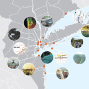
In a nutshell, the NYC Department of Parks & Recreation Forestry, Horticulture, and Natural Resources Division granted 93 research permits in 2015. Of these, 33 were renewals of existing projects. Applicant affiliations spanned the private, public, and nonprofit sectors, with the majority of applications from universities. Also, projects are occurring in all five boroughs as well as citywide and across parkland types. The borough with the most research permits issued is Manhattan and the park with the most permits issued is Central Park. City-wide/multiple borough research projects account for 32% of research permits issued.
In terms of research topic, over 35 permits have been issued for plant research followed by over 25 permits for soil and close to 25 permits for arthropods. Research projects about amphibians/reptiles and worms each have below 5 permits.
The oldest ongoing research project is the Breeding Bird Survey of New York City by Susan Elbin of NYC Audubon. The permit was first granted in 1982. The next oldest project is Melissa Cohen’s Electrofishing Fisheries Surveys. This NYS Department of Environmental Conservation project was started in 1996. See page 5 of the Research Permits Report 2015 Annual Report for permits issued between 2011 and 2014. I am excited about the Avian Acoustic Ecology Project by NYU graduate student Joseph Doumet and professor Tae Hong Park. The project is based in Washington Square Park! Check out Tae Hong Park’s Citygram, an “interactive environmental-sensing project.” Two recently permitted projects use “barcode” in the title: Urban Barcode: Worms in Cunningham and Francis Lewis Parks by Christopher Ades at St. Francis Preparatory School and Urban Barcode Project: Sunset Park by Megan Wallner at Sunset Park High School. Do you know about the Billion Oyster Project, to restore one billion live oysters to New York Harbor plus engage K-12 students in STEM? Kimberly Schwab of the Speyer Legacy School received a permit for Billion Oyster Project/ water quality monitoring. I’ll also mention Ronald Sarno’s, based at Hofstra University, Selective behavior by rodents in the built environment: A pilot. There are 55 other new and fascinating projects. For all the permits issued in 2015 see pages 6 and 7 of the Research Permits Report 2015 Annual Report.
 |
| Image: Screenshot of Figure 1: 2014 Science Plan Research Themes, page 1, New York City Urban Field Station 2014 Annual Progress Report |
So that was just one set of research in NYC parks. The other portfolio of research comes out of the NYC Urban Field Station, a collaboration between the USDA Forest Service Northern Research Station, the NYC Department of Parks & Recreation, and as of 2013, the Natural Areas Conservancy. Eight research buckets were summarized in field station progress report published in 2014. They are Tree and Vegetation Health, Disturbance and Recovery, Stewardship and Civic Engagement, Ecosystem Services and Health, Wildlife and Habitat, Inventory and Monitoring, Management Evaluation, and Ecological and Social Assessments.

Within each category are one to eight projects. One that I am particularly interested in following is Trees Flooded by Hurricane Sandy by Rich Hallett, Nancy Sonti, Ross Whitehead (Rutgers intern), and Michelle Johnson. After the hurricane I began thinking about how severe disturbances, especially to urban areas, affect people’s sense of place and collecting stories about tree elegies. My dissertation was about the transition of the role of the street tree from one of beautification to environmental service provision in the policy and planning arenas and the actors, institutions, and mechanisms that mainstreamed the ecological view of the street tree in California cities. Because of this experience, I am very curious about Lindsay Campbell’s project City of Forests, City of Farms in which she examined policy and planning documents and their implementation between 2007 and 2011 to theorize “how urban nature [was] constructed in New York City”. There are two bird projects. One, Lifetrack Egret, co-led by Erika Svendsen, Susan Stanley, Susan Elbin (NYC Audubon), and John Brzorad (Lenior-Rhyne University), tracks egrets using GPS and cell phone technology and each egret’s data is sent to a specific classroom to inform curriculum. The other is the Harbor Herons nest surveys by Susan Stanley and Susan Elbin. In addition to research, the Urban Field Station engages communities of interest through various science outreach and communication programs. The field station has dedicated staff but also supports, scholars-in-residence, fellows, interns, and fellows.
If you could, what kind of research project would you conduct in a NYC park, or in a park in your community?
Lead Image: Screenshot of Figure: Locations: Borough and Park, page 2, Research Permits Report 2015 Annual Report

5 Resiliency Lessons from NYC Stormwater Projects
| Exactly eight months ago, HUD Secretary and Chair of the Sandy Rebuilding Task Force Shaun Donovan announced the Rebuild by Design competition, an “innovation and resilient design in Sandy rebuilding” collaborative with the Rockefeller Foundation and the NYU Institute for Public Knowledge. Secretary Donovan remarked that the catalyst for the competition was the recognition that the federal government “cannot fill every need.” Ideas and additional funding are expected of other institutions and that universities, community leaders, nonprofit organizations, and citizens are essential to creating solutions that work across scales and interconnected systems. |

Image credit: rebuildbydesign.org
The clock for the competition started on June 20 with the request for qualifications due July 19. The competition, which has multiple phases, will announce its finalists next month. Selected ideas will be implemented with Community Development Block Grant Disaster Recovery money and funding from other public as well as private partners. Each team must have multi-disciplinary expertise and have active collaborations with local and regional institutions. The competition organizers and jury are seeking buildable solutions in four categories: small to mid-size coastal communities; high density urban environments; ecological and waterbody networks; and “outside the box” proposals.
Rebuild by Design was announced eight months after Superstorm Sandy made landfall in the region. However, immediately after, and in some cases well before the storm, various actors in New York City implemented and proposed best management practices for stormwater management. Stormwater here is broadly defined as upland or coastal flooding from ocean surge and surface runoff. Government, community-based organizations, nonprofits, and citizens have engaged in activities to reduce individual, community, and city-wide exposure and vulnerability to flooding and surge events. Risk reduction activities range from new and continuing landscape construction projects to recovery policies and plans by federal, state and municipal actors to design proposals by landscape architects and other allied professionals. Innovation is a hallmark of design competitions but in addition to reinventing the wheel thinking, it is worthwhile to glean not only design, but cultural, lessons from ongoing green-blue infrastructure efforts.

Image credit: rebuildbydesign.org
In the rest of this essay, lessons from five storm-water management projects will be presented. The cases are the dune restoration in Long Beach, NY; the Sunset Park segment of the Brooklyn Waterfront Greenway; wet meadow restoration and rainwater catchment in Brook Park in the Bronx; the Nashville Boulevard and 116th Avenue Greenstreet in Queens; and SCAPE’s Oyster-tecture proposal for the 2010 MoMA Rising Currents exhibition. These lessons should be useful to those engaged in the Rebuild by Design competition, as well as others engaged in stormwater management efforts.
Dune restoration in Long Beach, NY
One direct landscape intervention is the dune restoration in Long Beach, NY. In this community, approximately half a million cubic yards of sand were washed away during the storm. The diminished sand dunes make the community vulnerable to even the mildest of storm events.
Dune grasses require “a significant accumulation of sand” so residents proposed to city officials that discarded Christmas trees be placed on the beach to capture blowing sand. The New York Times also reported that other Sandy-affected communities as well as storm-prone communities elsewhere (Carolinas, Louisiana, and California) have repaired dunes with this method.
The dune restoration project in Long Beach offers two lessons. First, in the aftermath of disasters, citizens are often the “first responders” according to Erika Svendsen, a social science researcher with the U.S. Forest Service. Secondly, Keith G. Tidball and colleagues argue that the restoration response is not simply one of reducing exposure and physical vulnerability, but also of developing “social-ecological resilience”, i.e. post-disaster greening activities that beget community engagement and ecological learning.
Rebuild by Design teams should develop systems that (continue to) enable communities to respond effectively to disasters. Furthermore, proposals could be designed as living documents to easily accommodate ongoing learning as well as changes in a community’s demographics and geological form.
 |
| Image: Belltown P-Patch, Seattle |
Sunset Park segment of the Brooklyn Waterfront Greenway
Cultural perceptions of nature are another key lesson from ongoing water hazard reduction activities. According to the Brooklyn Greenway Initiative (BGI), a planning and long-term stewardship non-profit, the 14-mile, 23-segment Brooklyn Waterfront Greenway will incorporate green infrastructure strategies along much of its length.
Although BGI is the lead nonprofit for the greenway, a conceptual plan for the Sunset Park segment was commissioned by United Puerto Rican Organization of Sunset Park (UPROSE), a community-based environment, sustainable development and youth justice organization. Since culturally-appropriate design is identified as one of seven planning principles in the Conceptual Plan for a Sunset Park Greenway, “local stakeholders should be involved in the aesthetic design process for physical greenway elements so that the final product communicates a sense of identity and ownership.”
Although nature values are not specifically mentioned, given the nature of the UPROSE’s campaigns, it is likely that cultural ideas about what constitutes ecological design are embedded in its conceptual plan for the greenway. This call for culturally appropriate design mirrors Julian Agyeman’s concept of “culturally inclusive spaces” in which cultural aesthetic and use values of nature are honored while simultaneously stewarding ecological health and function.
The “look” of green infrastructure components for the Brooklyn Waterfront Greenway might be different than the traditionally linear bioswale as shown in typical design schematics. Anja Claus of the Center for Humans & Nature suggests that a swale could be “a string of landscape depressions of varying shapes representing some cultural story.” Furthermore, the swale could be vegetated with plant species that provide both cultural meaning and ecological function.
 |
| Image: Future site of wet meadow, Brook Park, Bronx |

Wet meadow restoration and rainwater catchment in the Bronx
The Friends of Brook Park has undertaken a restoration plan for a wet meadow and rain water catchment system along a section of the historic Mill Brook. The planning for the restoration project began long before Hurricane Sandy but claims about the project’s ability to reduce upland flooding and reduce contributions to downstream CSOs align it not only with the city’s pre-storm sustainability and green infrastructure plans but also with the post-storm rebuilding and resiliency plan.
The Brook Park project exemplifies the creative grassroots and capacity building of the Friends. When former Mayor Giuliani proposed to sell the city’s community gardens, South Bronx community groups coalesced around open space preservation. The park was created when its founders cut the fence around a local vacant lot and started an after-school program for with funding from the Mid-Atlantic Arts Foundation.
The restoration plan was initiated when a neighbor showed the Friends group maps of the historic creek in 2005. The park received a grant from the U.S. Forest Service Living Memorials Project to plant trees. Currently, the restoration project is in the design and implementation phase.
Although navigating the city’s green infrastructure bureaucracy has been challenging, this step-wise process has meant that the park’s stewards have been, borrowing from Marcia McNally, caring for and feeding their own grassroots. Grassroots does not imply lack of sophistication. The design for the stormwater capture wetland system is elegant. (Although the original Brook Creek flows under the site, it will not be daylighted in the traditional sense. An impermeable layer will separate the constructed wetland and the original creek flow.)
The wetland in conceived of as three separate ponds that will be fed by precipitation that falls on the site. The other source of water for the ponds will be rainwater harvested from the roofs of 28 adjacent townhouses. Runoff from a different set of five townhouses will be used for gravity-fed irrigation. The estimated combined total rainfall from townhouse roofs and the park is 39,281 gallons during a 1” rain event and 1,571,250 gallons annually.
 |
| Image: Furmanville Avenue Greenstreet, Queens |
Nashville Boulevard and 116th Avenue Greenstreet in Queens
At the Waterproofing New York symposium in March 2013, Jeannette Compton, director of the Green Infrastructure Unit of the Department of Parks and Recreation, described some of the city’s Greenstreets as “hyperfunctioning,” meaning that they perform beyond their footprint. The city’s Greenstreets program was initiated in 1996 with the Department of Transportation; the original objectives of the program were to “beautify neighborhoods, improve air quality, reduce air temperatures, and calm traffic” by vegetating impervious, unused road areas.
In 2010, the program evolved into the Green Infrastructure Unit and partnered with the Department of Environmental Protection to manage runoff and meet sewershed and water quality goals. The new Greenstreets are overdesigned to “absorb runoff from an area 10 or more times their size”.
This was illustrated at the Nashville Boulevard and 116th Avenue Greenstreet in Queens during Superstorm Sandy. Compton reported that the greenstreet received 1,200-1,300 gallons of direct rainfall and 39,000 gallons of runoff flowed into the system (surrounding storm drains were clogged with storm-generated debris).An approximate total of 40,000 gallons of water was handled by the greenstreet over the course of two to three days. Most of the water was held in the top layers soil and there was no water in the catchment basin which means the system had capacity to handle more water. The new portfolio of Greenstreets can handle routine 1” rain events as well as hurricane-level precipitation.
![]()
Image via Wikimedia
Oyster-tecture by SCAPE
Also, it is okay to be radical. Kate Orff, who heads the landscape architecture firm SCAPE, submitted Oyster-tecture, “a living reef” of oysters, mussels and eelgrass, to the MoMA Rising Currents exhibition in 2010 (one year before Hurricane Irene and two years before Superstorm Sandy). At the time, the concept of oyster-tecture was fairly radical. Although oysters were known to attenuate wave action, designing green infrastructure with oysters was not a mainstream strategy in New York in 2010, though the times have changed. Oyster reefs have even been listed as a strategy for coastal protection in the NYC Special Initiative for Rebuilding and Resiliency report released in June 2013.
Five lessons
There are five lessons from the case studies outlined above.
- One, plans to reduce risk in coastal and upland areas should acknowledge the critical first responder role played by residents.
- Two, design solutions should function in typical and beyond anticipated storm scenarios. However, these hyper-functioning solutions should not be supersized; they should match the scale of the neighborhood.
- Three, competition participants should take inspiration from Oyster-tecture and follow their outside-the-box concepts.
- Four, community members should also pursue their creative solutions; wetlands in the Bronx are not uncanny.
- And five, don’t ignore local strategies and community planning in the push for regional solutions and master planning; the sustainability of Rebuild by Design proposals will require that local visions of nature are meaningfully incorporated into projects.
Lead Image: Current Rebuild by Design proposals via Rebuild by Design (source)
Follow Rebuild by Design at http://www.rebuildbydesign.org.
Additional photographs of Brook Park are available at Nature Park – Brook Park.
Originally published on Thursday, February 6, 2014 as “5 Lessons for Rebuild by Design from existing NYC stormwater projects” on local ecologist.