


Author: Nathan Polanski

Green Stormwater Infrastructure & Streetscapes
Integrating Green Stormwater Infrastructure into the Streetscape
Across the country, local governments are integrating green stormwater infrastructure (GSI) into the streetscape to manage urban stormwater runoff. More frequently implemented to reduce combined sewer overflows (CSOs), streetside GSI also treats polluted runoff that includes oil, heavy metals, and carcinogens to help protect the quality of local water bodies. Often overlooked, however, is the vital role that GSI can play in creating a thriving, pedestrian-friendly streetscape by providing physical buffers, reducing imperviousness, increasing opportunities for tree canopy, mitigating heat island effect, and promoting traffic calming.

Left: Department of Environmental Protection, Montgomery County, MD
Right: image and design by MIG, Inc.
With so many co-benefits, it’s curious that current design manuals offer little guidance for how to integrate GSI into the streetscape. Nor do they discuss how design details of facilities such as bioretention cells impact users of the street. The Green Book—the nationwide “Bible” for right of way engineers, published by the American Association of State Highway and Transportation Officials (AASHTO)—states that streets should “serve as a catalyst to environmental improvement” and that landscaping should “mitigate the many nuisances associated with urban traffic” and “make streets better neighbors.” But the Green Book does not discuss how emerging practices such as GSI might improve the public realm for pedestrians, bicyclists, and the built environment.
In the absence of such national standards, a body of best practices is emerging from applied experience.
First, consider the context. When designing a bioretention cell or other GSI facility for the public streetscape, think about where the facility sits in the neighborhood and along the street. Some typical contextual factors to consider include:
- Land-Use and Streetscape Character: Who are the typical users along the street (i.e. age, ability, and type) and how might the proposed GSI facility impact those users? Were the surrounding parcels recently rezoned? If so, how will those new buildings be used? Also, what is the look and feel of the streetscape and how might design elements like side slopes or vertical walls, length of a GSI facility, edge treatment, and plant selection enhance the streetscape?
- Access: How will the placement of GSI facilities impact non-motorized and vehicular access along the street? How will pedestrians navigate across the GSI facility to the public sidewalk? Will bicyclists who use the curb zone to pause along the street be impacted by GSI facilities? What about intersection visibility?
- On-street Parking: How will GSI facilities work with adjacent on-street parking needs and patterns? How will retrofitting GSI into a new curb bulb or curb extension impact parking supply and availability?
- Existing Utilities: What kind of impact will GSI facilities have on existing utility mains, structures, services, and easements along the street? Is tree planting limited due to overhead power lines? Do underground utilities prevent infiltration?
We can see how different design decisions and details incorporated into a GSI facility affect pedestrian access by examining pictures of constructed GSI facilities from across the country. The following images show four different configurations for integrating a stormwater planter (i.e. bioretention facility with a vertical edge) into the streetscape.
 Top left: Milwaukee, WI – image: Robert Kuehn; Top right: Portland, OR – image: SvR Design Company; Bottom left: Milwaukee, WI – image: City of Milwaukee; Bottom right: Portland, OR – image: SvR Design Company
Important design details for each installation include the following:
- Access/egress zone for on-street parking: Is parking allowed on the street? Is a dedicated zone for opening car doors and getting into and out of vehicles in the parking lane provided? What is an appropriate dimension for this space and what materials should be provided for surfacing?
- Edge condition at vertical drop: Is a barrier or buffer provided between pedestrian access areas and vertical grade changes to reduce tripping hazards for pedestrians? What are impacts for users unloading from or backing out of the car when no barrier or buffer is provided?
- Length of GSI facility: How does the length of the facility limit or direct access to/from on-street parking and the sidewalk?
Second, deeper is not always better. The depth of a bioretention facility is often driven by stormwater goals (i.e. maximum temporary ponding depths) and existing site characteristics (e.g. longitudinal street slope). But designers should also understand how the GSI location works within its context and adjust the GSI facility design accordingly. Stormwater manuals provide technical guidance for designing a functioning stormwater facility but they cannot tell you how to design for a gracious streetscape. As a pedestrian, what depth feels comfortable to walk next to? While building codes allow an up to 30-inch vertical grade change before requiring a guardrail, this guidance may not be appropriate for GSI within the public right of way; for vertical drops, maximum depths of 18-inches or less should be considered. Also, how might the planting design– size, selection and spacing of plants–impact public perceptions of the facility depth?
 Seattle, WA
image: SvR Design Company
Integrating traffic concerns. Beyond dimensional details of GSI facilities, traffic related elements must also be considered such as street signage or markers. The Green Book discusses fixed objects along the roadside and the need for signage to alert drivers of potential safety hazards for items like curb extensions. However, as curb bulbs and curb extensions become a common element of street design considerations should be made for how signage and pavement markings impact the aesthetic and neighborhood character. The images below show a variety of ways to mark or delineate GSI facilities in the streetscape that appear as effective as the striped object marker. The designer should review what level of intervention is appropriate. For example, are there opportunities for a design approach that allows for flexibility based on the context rather than a blanket approach derived from past roadway design manuals? Designers should understand the intent of the manual being applied and consider whether an alternate approach to achieve the same goal is appropriate.

Hoboken, NJ
image: City of Hoboken
Regardless of the local climate, rainfall patterns, and soil conditions (each important in the specific design of a GSI facility) the items discussed above highlight the need for a comprehensive guide to support the emerging practice of integrating GSI into the streetscape. Applying the standard details of another agency or the design of a successful project will not necessarily translate to success for your project. Our cities’ rights of way are increasingly contentious spaces, seeking to accommodate the demands of a variety of uses and users. It is important that GSI facilities are designed with consideration for all of these uses and users, as well as future operations and maintenance.
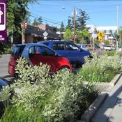
Lead image: Winslow Way streetscape, Bainbridge Island, WA | design and photo by SvR Design Company
The above article was written by Professional Engineer Nathan Polanski, nathanp@svrdesign.com of SvR Design Company. It was based on a presentation Nathan gave to the Landscape and Environmental Design Committee of the Transportation Research Board at that organization’s Annual Meeting in Washington, DC this January. This post first appeared on The Field.