Author: Pamela Hartford
Four Leading Landscape Architecture Firms Selected to Tackle DC’s First Elevated Park
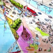
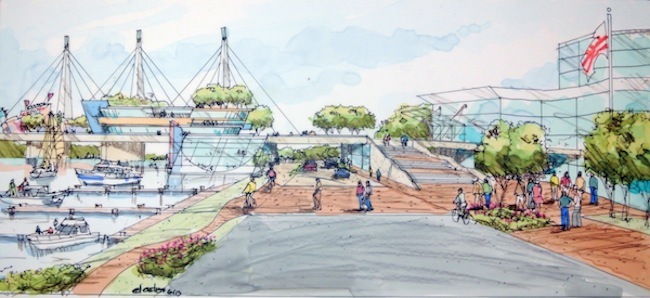
Washington D.C.’s 11th Street Bridge Project Jury recently selected four outstanding design teams to develop designs for the city’s first elevated park. With some of the top landscape architecture firms at the helm, these teams will develop a concept to creatively reclaim an unused bridge spanning the Anacostia River between the Capitol Hill and Anacostia neighborhoods.
The four teams, which are made up of landscape architects, architects and structural engineers, each received $25,000 to create full renderings and plans to be delivered by September. The teams are:
• Balmori Associates / Cooper, Robertson & Partners / Guy Nordenson Associates
• OLIN / OMA / Arup
• Stoss Landscape Urbanism / Höweler + Yoon Architecture / Robert Silman Associates
• Wallace Roberts & Todd (WRT) / NEXT Architects / Magnusson Klemencic Associates
The District government and a local nonprofit organization, Building Bridges Across the River at Town Hall Education Arts Recreation Campus (THEARC), hope to transform the bridge into the city’s first elevated park, and reap the myriad benefits that have come to be known as “the High Line Effect.”
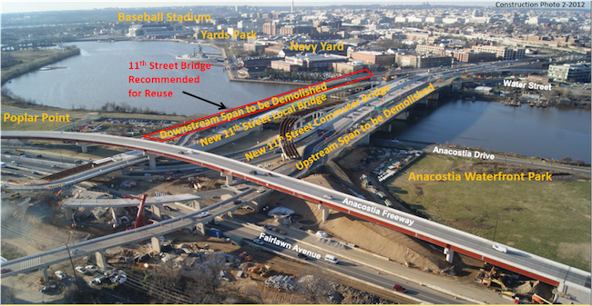
Previously, the unused span was due to be demolished as part of a District Department of Transportation (DDOT) plan until the 11th Street Bridge adaptive reuse project was proposed as an alternative. The new space aims to offer a park unlike any other in DC and will offer healthy recreation, environmental education and space for the public arts.
Although inspired by the High Line, the 11th Street Bridge Project differs significantly in size, scope and approach from NYC’s acclaimed 2009 park. Whereas the High Line is a reclaimed rail line that snakes through the posh and dense Chelsea district, DC’s proposed elevated park straddles a major river and would connect the economic and racial divide between the wealthier Navy Yard and the poor Anacostia neighborhoods.
(SEE ALSO: NYC’s High Line Park Celebrates 5th Anniversary)
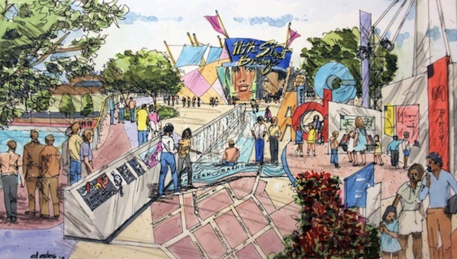
Instead of working within a narrow linear footprint, the 11th Street Bridge will cover the equivalent of three football fields and include the area along the river underneath the new connector ramps. This will give the designers and the community the opportunity to include more active space for programs such as urban agriculture and performance. The width of the bridge could even accommodate a future streetcar.
A major physical challenge will be figuring out how to entice and bring residents from the Anacostia neighborhood over to the bridge. The connector ramps are currently located along the Anacostia side of the river and there is a quarter of a mile gap between the neighborhood and the waterfront.
Unlike The Friends of the High Line, the District government and the THEARC have taken a different approach in preparing for D.C.’s first elevated park. Whereas Friends of the High Line first selected a winner in a design competition before working on the design, THEARC sought input ahead of the design competition by holding nearly 200 meetings with constituents from neighborhood stakeholders and public agencies to non-profits that represented sectors such as recreation, health care, and social services.
These community meetings then developed goals that indicate big social and cultural agendas as well as economic and environmental objectives:
- Unify DC by reconnecting the neighborhoods on both sides of the river;
- Establish a safe place for residents to exercise and play;
- Re-engage the community with the Anacostia River;
- Generate new jobs and economic activity
With a wish list that already includes neighborhood ‘wants’ such as outdoor performance space, environmental education classrooms and even river access with kayaks and paddleboats, the designers will be challenged to create a civic space for Washington DC that has both wide and long lasting appeal.
Renderings by Ed Estes, courtesy of DC Office of Planning
Construction image courtesy 11th Street Bridge Park
10 Inspiring Landscape Architecture Reclamation Projects
Adapt Reuse Reclaim: 10 Landscape Design Projects That Turned Damaged, Neglected Places into Healthy, Beautiful Environments
Landscape architects frequently work to transform areas that contain industrial and toxic waste, infrastructure no longer in use, or land affected by war, natural disaster or disuse. These neglected places, while often having a negative impact on the environment and surrounding community, are simultaneously part of our cultural heritage. To highlight the significance of these spaces, and the potential that they hold to become something more than a blight, I showcase a range of projects that illuminate how designers use unlikely opportunities to transform landscapes into spectacular spaces—all while preserving their historic and cultural meaning. These 10 case studies showcase the creative approaches city governments, preservationists, developers and designers have taken to transform marginalized places into healthy and meaningful environments for everyone to enjoy.
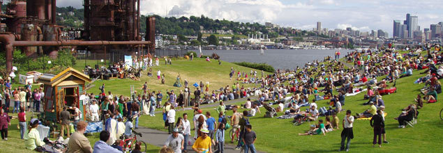
Photo courtesy Gas Works Park Wikimedia
Reuse & Reclamation: Abandoned Industrial Site
Gas Works Park in Seattle, Washington
Designer: Richard Haag
In 1965, the design for Gas Works Park transformed a former coal gasification plant into an enormously popular public park. A central feature, the boiler house, was converted into a picnic shelter complete with tables and fire grills, while a former exhauster-compressor building was turned into an open-air play barn that houses a maze of brightly painted machinery for children. This groundbreaking project has been celebrated for its ability to garner local support and shift public perceptions of post-industrial landscapes. It is considered revolutionary for its reclamation of polluted soils using the natural processes of bioremediation, while uniting aesthetics with sound ecology.
Duisburg-Nord Industrial Landscape Park ©DZT/Landschaftspark Duisburg-NordGmbH (Mark Wohlrab)
Reuse & Reclamation: Post-Industrial Factory Landscape
Landscape Park Duisburg Nord in Duisburg, Germany
Designer: Latz + Partners
Working on a 570-acre site of a former steel plant, Latz + Partners’s approached their reuse and reclamation project with optimism. Rather than looking at the site’s disturbed and complex conditions as nuisances that should be erased or camouflaged, they worked carefully to mine them for their creative potential. The transformed site creatively repurposes existing structures, and throws in a number of amenities that promote recreation and community, including a deep diving pool, a rock climbing wall, picnicking areas, hiking trails, and multiple performance spaces—all woven together to create tapestry of memorable places. The aim was to change the industrial landscape with minimal intervention, recycling and visually renewing decaying architectural objects into poetic places that pay homage to the site’s past.
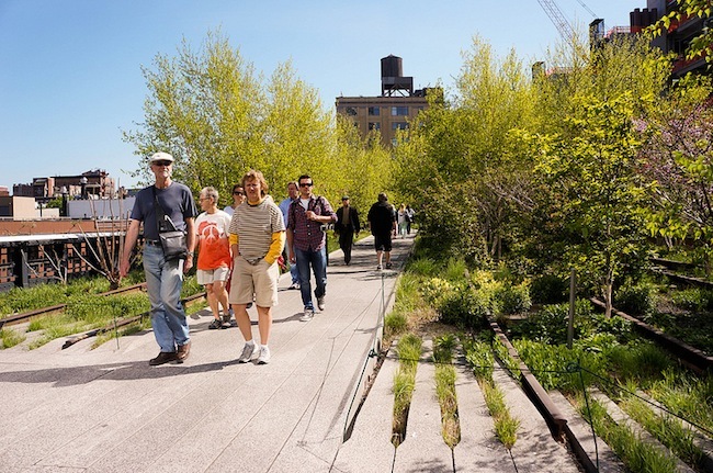
Courtesy Landscape Voice
Reuse: Abandoned Transportation Infrastructure
The High Line in New York City
Designers: James Corner Field Operations, Diller Scofidio + Renfro, and Piet Oudolf
The High Line is a one mile stretch of abandoned elevated railroad on New York’s West Side, which was under threat of demolition. After years of public advocacy, it has been resurrected as a park that’s become one of the city’s most popular destinations. The park’s attractions include naturalized plantings that are inspired by the self-seeded landscape that grew on the disused tracks, unexpected views of the city and the Hudson River, and cultural attractions that are thoughtfully integrated into the architecture and plant life. The project cost substantially less than it would have been to wholly demolish and redevelop the area. Preservation and innovation come together through the adaptive reuse of the existing structure as a new, compelling, one-of-a kind recreational amenity and public promenade.
Remediation: Brownfield into Greenfield
Alumnae Valley, Wellesley College, Wellesley MA
Designer: Michael Van Valkenburgh Associates
Michael Van Valkenburgh Associates worked with Wellesley College to revitalize the toxic brownfield of Alumnae Valley, an area that previously hosted the college’s power plant, industrialized natural gas pumping stations, and a 175-space parking lot. Managing the corrupted soil involved several strategies: removing the most toxic soil, capping and collecting the mildly contaminated soil, and then finding a way to reuse it as part of the landscape. The site was originally shaped by Ice Age glaciers. The mounds along the paths mimic the original sculpting of the land while storing remediated soil. The integration of topography, hydrology, and campus life brings Alumnae Valley back into harmony with its surroundings.
Courtesy James Corner Field Operations
Reclamation: Wetlands from Wasteland
Fresh Kills Park in Staten Island, NY
Designer: James Corner Operations
Fresh Kills Landfill has become a model for landfill reclamation around the world, having been transformed into a vast green space full of wildlife. The site is large enough to support many sports and programs that are unusual in the city, including activities and features such as horseback riding, mountain biking, nature trails, kayaking, and large-scale public art. Demonstrating the role of wetland buffers in battling rising waters, Fresh Kills absorbed a critical part of the storm surge during Hurricane Sandy. With the help of advanced landfill gas collection infrastructure throughout the area, methane is actively harvested from the decomposing waste, providing enough gas to heat 22,000 homes. The transformation of what was formerly the world’s largest landfill into a productive and beautiful cultural destination demonstrates how landscape architecture can restore balance to the land.
 Photo by Kongjian Yu, Cao Yang courtesy ASLA
Reclamation: Waterfront Revitalization
The Red Ribbon in Tanghe River Park, Qinhuangdao City, Hebei Province, China
Designer: Beijing Turen Design Institute and Peking University Graduate School of Landscape Architecture
Much of the original site, located at the edge of a largely inaccessible beach, was used as a garbage dump and included deserted slums and irrigation facilities. The goal of the Tanghe River Park project was to preserve as much of the natural river corridor as possible, promoting the lush, diverse, natural vegetation. Instead of paving over the riverfront with hard pavement and planting ornamental flower beds, the design employs a “red ribbon” steel structure stretching 500 meters along the riverbank. This feature provides access for jogging, fishing, and swimming, with minimal impact on the landscape. The red ribbon snakes along a boardwalk that provides walking access throughout the park. Many of the park visitors are former farmers and “newly urbanized.” The park gives visitors an environmental connection with rural China.
Rendering by Mossop + Michaels
Disaster Response: Sustainable Farming
Viet Village Urban Farm in New Orleans, Louisiana
Designer: Mossop + Michaels
Viet Village Urban Farm is an urban farming project located in New Orleans East, an area hard hit by Hurricane Katrina. Before the devastation of the hurricane, there were over 30 acres of community-farmed land growing traditional Vietnamese fruits and vegetables. Mossop + Michaels‘ new design for a 28-acre farm will sit in the middle of a dense urban environment, continuing the tradition of urban farming that Vietnamese immigrants started there in the 1970s.The design will employ sustainable irrigation techniques that require little or no electricity to pump and filter water used in the fields. And the organic crops produced on site will be sold at a new on-site farmer’s market estimated to accommodate the 3,000 Saturday shoppers who had previously bought foods these community farms before Katrina hit.
Photo by Sam Rosenhotlz © Boston Architectural College
Recharging: Permeable Paving
The Green Alley at Boston Architectural College in Boston, Massachusetts
Designer: Halvorson Design Partnership
Boston’s Back Bay neighborhood, built on landfill in the 1880s, features rows of elegant brownstones along tree-lined streets with public alleys running behind the buildings providing service areas for deliveries, trash storage, and parking. The Green Alley, located on the Boston Architectural Campus (BAC) in Public Alley 444, lies between the college’s 951 Boylston Street building and 320 Newbury Street building. It has been redesigned to recharge the groundwater by filtering stormwater from alley surfaces and two BAC rooftops through permeable asphalt and paver systems and substrate. Below ground, geothermal wells serve the college’s core buildings and lead BAC towards their net-zero campus energy goal. A vertical steel grid rises up two sides of the Boylston building for greenery to help reduce the heat effect in this narrow urban canyon. As a design school promoting practice-based design, BAC’s commitment to sustainable approaches in urban design and collaborative processes is fully demonstrated through this replicable approach to the Boston Back Bay alleys.
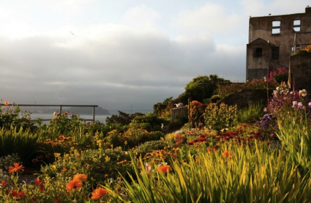
Photo by Elizabeth Byers, 2011
Rehabilitation: Public Gardens
The Gardens of Alcatraz in San Francisco Bay
The Garden Conservancy, National Park Service, and National Parks Association
During the military and federal prison periods, staff and prisoners transformed much of the Alcatraz Island’s landscape into intensively maintained gardens. The gardens served as refuges from the harsh surroundings, becoming an important part of everyday life for officers, families, and prisoners confined to the island. With the closure of the federal prison in 1963, the gardens were abandoned. After extensive planning, removal of overgrowth, planting, and repair of deteriorated structures, the gardens are blooming once again for the thousands that visit the island daily.
Rendering by Stoss Landscape Urbanism
Re-imagining: Memorializing Battlefields
Herinneringspar in Westhoek, Flanders, Belgium
Designer: Stoss Landscape Urbanism
Scheduled to open in 2014 on the 100th anniversary of the outbreak of World War I, Herinneringspar park is a joint venture between the Flemish state government and the Belgian federal government. The war and its aftermath have had significant physical and ecological impacts on the Westhoek landscape—from the flatlands to the deforested and bombarded fields to the agricultural farmlands. This project will create a regional remembrance park along the front lines of the war, memorializing key battlefields through a series of ephemeral plantings and atmospheric effects within the agricultural fields. The design pays tribute to the area’s military past, while also acknowledging the agricultural present and suggesting a resonant future.
Lead image via Duisburg-Nord Industrial Landscape Park ©DZT/Landschaftspark Duisburg-NordGmbH (Mark Wohlrab)
About Pamela Hartford:
Since earning a BA in architecture, Pamela Hartford has put her design education to use in both editorial and landscape design projects. Moving to Salem, Massachusetts and working in a historic district piqued her interest in landscape history and preservation, inspiring her to pursue a certificate in Landscape Design History from the Landscape Institute. She is researching the work of landscape architect Warren Manning, a disciple of Frederick Law Olmsted, for the Library of American Landscape History, and unearthing the horticultural history of Salem in the archives of the Peabody Essex Museum. She is interested in how cultivated (productive) landscapes have shaped our aesthetic and emotional response to landscape.


