Author: Vectorworks, Inc.
Designing Sustainable Rooftop Ecosystems: PWP Landscape Architecture
Sponsored Post
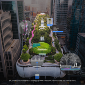
The Salesforce Transit Center rooftop park is a marvelous ecosystem resulting from years of forethought and planning. Spanning four city blocks and 5.4 acres, the rooftop park eases into several distinct sections, including feature gardens suited to San Francisco’s climate. Additionally, a water jet system shoots upwards whenever a bus passes underneath, allowing viewers to track its speed.
Let’s meet the firm responsible for this project’s landscape architecture.
Get to Know PWP Landscape Architecture
PWP Landscape Architecture has been a leader in the field of landscape architecture for decades. Established in 1983, this world-renowned firm has a pedigree that includes dozens of iconic projects from around the globe ranging from urban parks to corporate landscapes and ecological restorations.
They’ve won countless awards and accolades. Notably, they’re credited with the design of the National September 11 Memorial in New York City, which stands as a powerful symbol of remembrance and healing. Whether it’s restoring an old garden or creating something entirely new, PWP has time and time again demonstrated the ability to bring beauty to a space and craft unforgettable spaces for people to enjoy.
PWP firm members discuss their extraordinary history of designing to scale in this video. Following the video, you’ll find a closer look into some of the remarkable design decisions made by PWP for the Salesforce project.
Design Concept: Making a Dense Urban Area Greener
The Salesforce Transit Center project site in downtown San Francisco is surrounded by skyscrapers and blended in with the dense urban landscape. However, the expansive rooftop was transformed into a semi-isolated ecosystem that sequesters carbon and creates a better environment for the community.
The project challenges the importance of buildings over nature and invites visitors to consider nature’s essential role through informational signage about plantings and wildlife present in the micro-ecosystem.
The project incorporates several sustainable solutions such as collecting and treating storm and sink water for reuse in restrooms. PWP’s efforts led to a change in San Francisco code to allow greywater reuse in commercial applications.
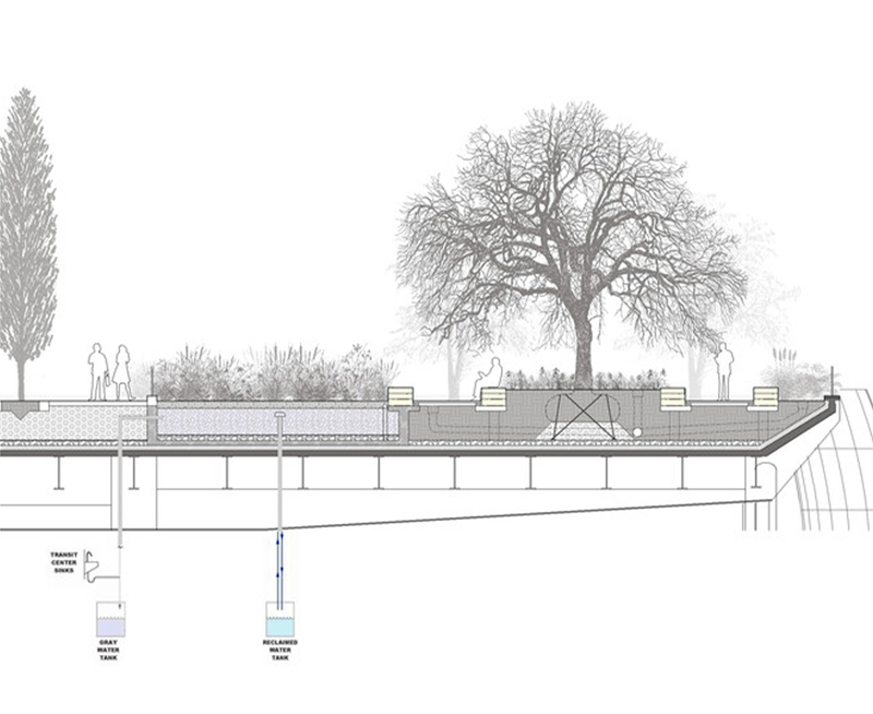
Image: PWP Landscape Architecture
The center’s plantings also absorb bus exhaust and supports a biodiverse ecosystem with over 50 species of trees and 230 species of plants. Though non-native plants were included, those chosen provide ecological support to native animals drawn to the site.
Design Process: Taking Advantage of Design & BIM Software for Iteration & Collaboration
Collaborating with engineers, ecologists, and architects is crucial to designing a lush greenspace above ground level with structural integrity. Vectorworks Landmark aided PWP in incorporating the knowledge of these consultants into their landscape architecture process. The software’s flexibility allowed for the creation of instant, scalable graphics, and the exploration of multiple design options.
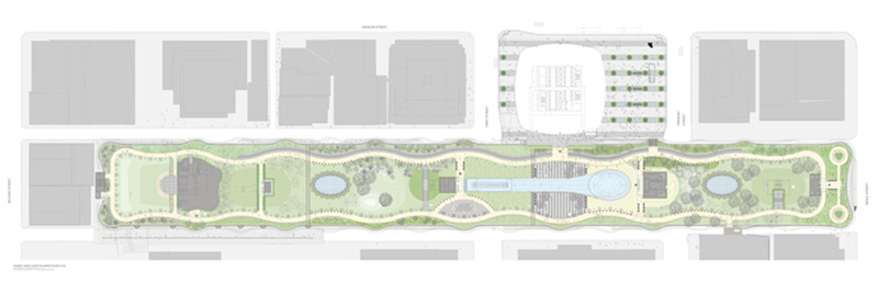
Image: PWP Landscape Architecture
“The advantage of the software is that you’re able to create good graphics instantly and at scale,” said Cornelia Roppel, senior associate and one of PWP’s lead designers for the Salesforce project. “Sometimes we end up with eight to ten different design options in one file, which we study and narrow down to two or three. Studying these options graphically and discussing design opportunities is what we do using the flexibility of Vectorworks.”
Learn more about the PWP’s landscape architecture process for the Salesforce Transit Center rooftop project by reading the full article here!
Landscape Architecture Firm Discusses “Most Compatible” Design Software
Sponsored Post
Landscape architects are always on the lookout for the design software that caters to their specific needs. However, selecting the right software can be an arduous task as there are many options available in the market. With each software boasting a unique set of features and tools, it can be challenging to determine which one is the best fit.
The story of Surface 678 from Durham, North Carolina encapsulates a journey familiar to many landscape architects. The firm started using AutoCAD for their projects and eventually found that the program doesn’t quite have enough capabilities dedicated to landscape architecture.
Enter Vectorworks Landmark. The firm tested the software for their workflow and discovered amazing results. They’re able to manage a project from hand drawings through to rendered presentation packages. They’re a prime case study in how a landscape-specific software brings loads of benefits to a landscape architecture practice.
Hear from Surface 678 team members about adopting Vectorworks Landmark:
Artistic Drawings Ease Communication
The range of Surface 678 projects in the video showcases one of the defining aspects of the firm’s work: incredibly illustrative drawings.

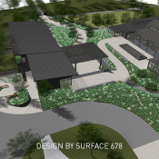
Courtesy of Surface 678.
Not only are these drawings graphically pleasing, but they’re also detailed and full of important context. These drawings serve the major purpose of communicating design intent with the client, and the firm can produce them in a personalized graphic style.
“A lot of clients don’t understand how to interpret construction drawings,” said Kyle Gename, landscape designer at Surface 678. “Being able to do something that looks more like a digitally rendered drawing is really helpful in terms of communication.”
Landscape-Specific Tools Enable Smarter Workflows
With Vectorworks Landmark, landscape architects have access to a variety of tools built specifically for their trade. Site modifier tools, for example, allow site designers to accurately grade the site and easily perform cut/fill calculations.
One of the benefits of Landmark, according to Gename, is the ability to automate repetitive tasks. Getting an accurate plant count for the site is crucial, but it’s a tedious process to count the plants individually. Landmark’s Plant tool and built in worksheets can generate plant schedules automatically for the landscape architect.
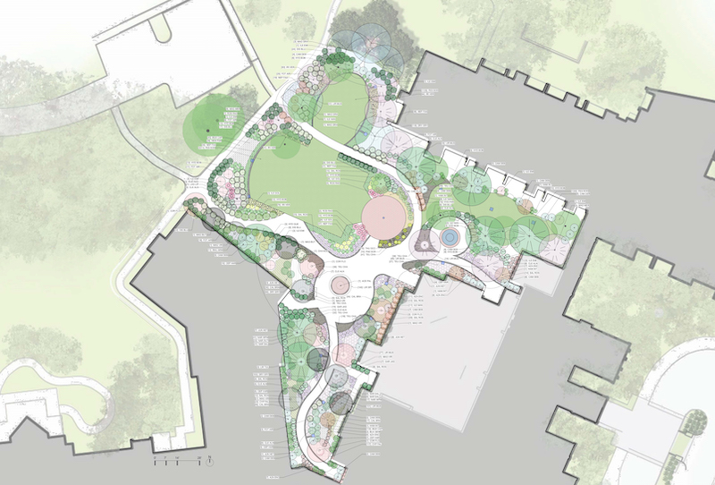
Courtesy of Surface 678.
The firm uses the tools in Landmark to create analysis diagrams for water use, sun patterns, and more.
Another draw to Landmark is its advanced data management capabilities. Should a collaborative project be undertaken with building information modeling (BIM), Landmark has everything the landscape architect needs to participate in the BIM process, such as collaboration via industry foundation classes (IFC) and connections to popular model coordination programs. Not to mention the ability to exchange files in common formats like DWG, RVT, and more.
Fluidity in the Design Process
Yaussy shared that the firm now only uses one to two software programs on their projects as opposed to the three or four they used before switching to Vectorworks. He used the word “fluid” to describe their workflows in the software.
And the firm is still able to start their projects how they like: with a pencil and paper. They import initial drawings into Landmark where they add “dimension and specificity” to the drawing.
With their previous workflow, they may have had to use one software for dimensioning the drawing, another for transforming it into 3D, and another for adding the graphical flair they’re known for. That’s a significant amount of time spent migrating files between programs that weren’t necessarily built to work together cohesively.
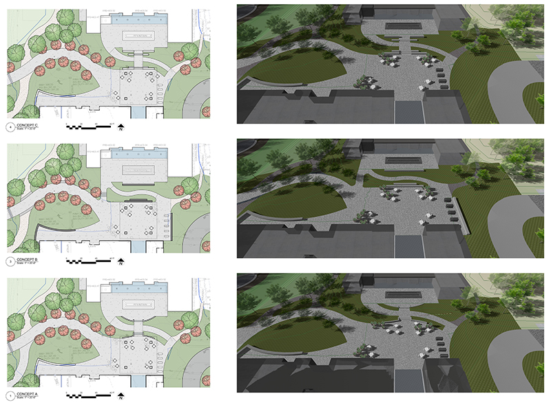
Courtesy of Surface 678.
“We use Landmark because it’s easy,” Gename said. “It has everything we need in one software.”
Curious what transitioning from AutoCAD to Vectorworks for landscape architecture looks like? You can find everything you need in this guide developed by Vectorworks Landmark experts.
How Vectorworks Landmark Saves Algarve Landscape Architects Money
João Rodrigues, co-founder of Portugal’s Algarve Landscape Architects, ALA, cites his Vectorworks Landmark experience as the backdrop for the shock he feels knowing many landscape architects aren’t demanding more from their design software.
Rodrigues, who used to use AutoCAD, decided he needed more back in 2009. “We could’ve gotten additional plug-ins to make the software do what we wanted,” he said, “but that’s like putting new paint on an old car. And we wanted a new car.”
ALA’s Pontal project, a masterplan handed over by the Portimão city council and various engineering teams, serves as a looking glass into a sophisticated landscape architecture workflow whose timelines would double or even triple without Landmark.
The Pontal Project — Showcasing Vectorworks Landmark’s All-in-One Workflows
The project was a carryover from the Portimão city council, who’d created 2D drawings for a parking plan, a connecting bridge, and a few areas for greenery.
The drawing ALA received from the council was a 2D plan that contained a red arrow indicating intentions for a ramp. Various other site elements were noted, such as tree symbols and lines to represent boundaries.
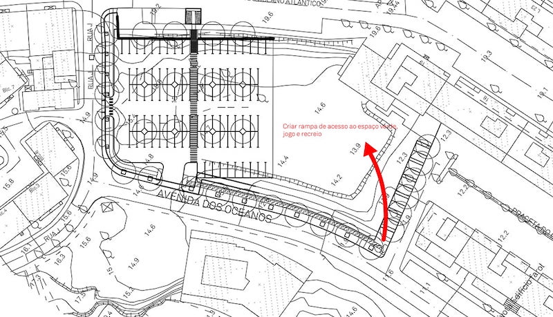
Image: Courtesy of Algarve Landscape Architects
Following receiving the concept from the council, ALA worked with the plans to help give them a broader vision of the result.
So ALA started by georeferencing the site into Vectorworks, making sure to indicate latitude, longitude, and Z direction on the drawing. This ensured that the project matched real-world coordinates and gave them a good baseline from which to design.
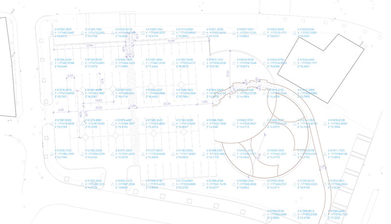
Image: Courtesy of Algarve Landscape Architects
With the georeferenced file established, the landscape architects could then work on surveying the site’s existing conditions. Using Landmark’s Existing Tree tool and the Import Tree Survey command, ALA were able to catalog the site’s existing trees and their data such as species, size, and maintenance needs.
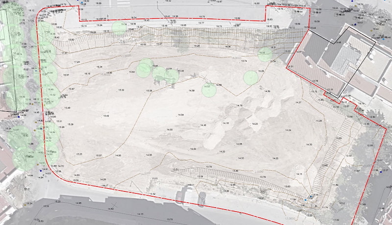
Image: Courtesy of Algarve Landscape Architects
A survey of 3D points and contours allowed ALA to generate a model for the existing site. They then used Data Visualization for analysis of slopes and water flow.

Image: Courtesy of Algarve Landscape Architects
Having an accurate 3D representation of pre-existing conditions gave ALA a reliable understanding of the site, so much so that they were even able to produce cut/fill calculations from a new grading plan.
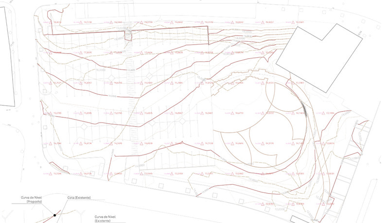
Image: Courtesy of Algarve Landscape Architects
At this point, a proposed planting plan was one of the major remaining needs. Rodrigues shared that he loves using the Plant tool in Vectorworks Landmark because it allows him to perform the entirety of his planting workflow in one program, from inserting massings to show intent all the way to data-rich, specified individual plant symbols.
Data Tags allowed ALA to quickly label their plants including information like botanical name, size, and quantity. Because these are linked to the plant symbols and documentation, any changes are automatically reflected.
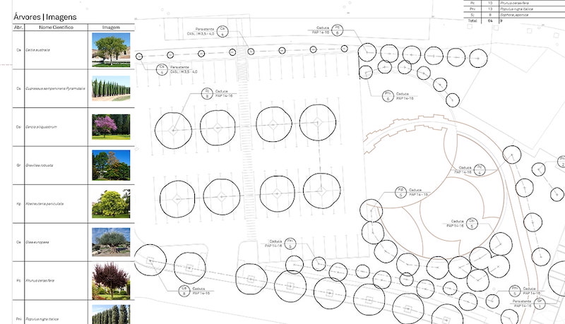
Image: Courtesy of Algarve Landscape Architects
“I’ve presented on this line of work twice,” Rodrigues said. “One of the big things I emphasize is our speed with Landmark. In Vectorworks, for tasks like inserting symbols for the site’s trees, it’s a matter of minutes.”
ALA’s process culminated in a detailed 3D model that contained all the information needed for implementation, including cost estimates.
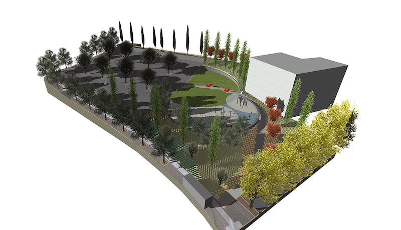
Image: Courtesy of Algarve Landscape Architects
One compelling aspect of Algarve’s process is how they 3D print both the pre-development site model and the proposed site model by exporting a .STL file. Rodrigues said this helped for further analysis, especially for eventually helping the client understand the site’s new grading.
“When I presented this to the client, they were very surprised,” Rodrigues said. “’Oh, what is this?!’ they said. And that’s the thing — you never see 3D-printed site models, but with Vectorworks, all the work is already done. This is just take-offs from the model.”
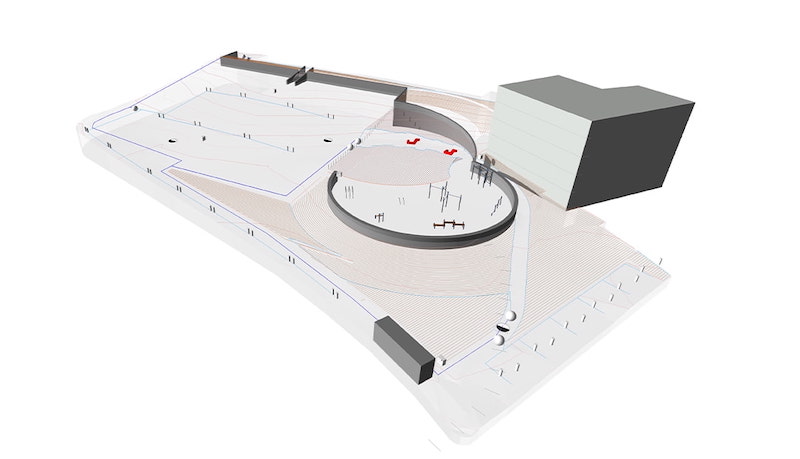
Image: Courtesy of Algarve Landscape Architects
With their concept detailed, the landscape architects were ready to send the proposal to the city council. They rendered the model in Twinmotion and included video animations of changing seasons so the council could understand how the site would look year-round.
Time Is Money
The above process took ALA two weeks, after which it went to the council for final review. When the council returned revisions, ALA fulfilled the final proposal in just three weeks.
This timeline, Rodrigues explained, is a complete overhaul of the firm’s past AutoCAD workflow. He demonstrated this by comparing timelines for creating fully developed planting plans.
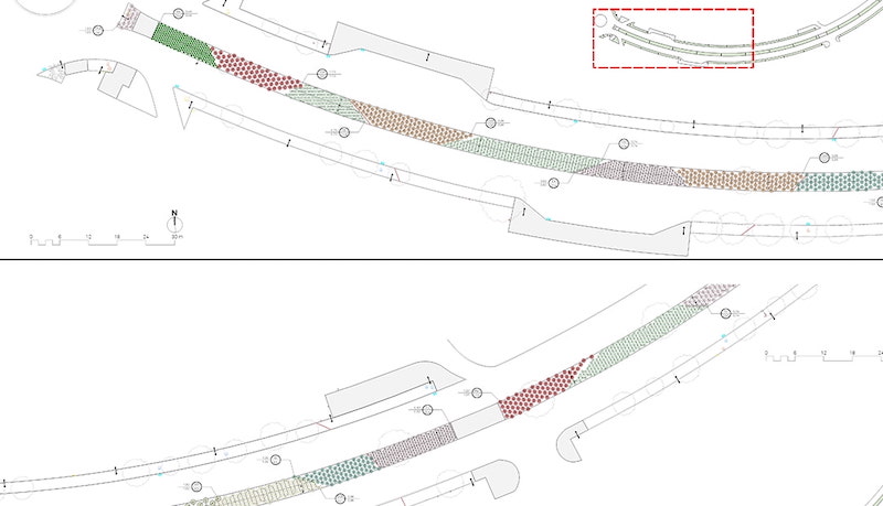
Image: Courtesy of Algarve Landscape Architects
The topmost section is a planting plan that Rodrigues worked on with 4 colleagues. He said it took three weeks to complete it. Below that is a planting plan done with Landmark — it’s a 3,000-plant scheme that ALA accomplished in just one workday with only two people.
“AutoCAD only lets you place, say, four plants per square meter,” Rodrigues said. “We need to design the planting scheme to appear exactly as we want it installed. Doing it in Vectorworks is just more realistic and so much faster. I don’t even know how to begin thinking about doing it in AutoCAD. It would just take so much time to get this detailed.”
“More Landscape Architects Need to Be Using Landmark.”
In Portugal, Rodrigues explained, government projects are often won by the firm who’s able to produce the quickest result for the least amount of money. This narrative is much of the reason why Algarve chose Vectorworks Landmark; it was imperative that they be able to produce high-quality work in a fraction of the time that they were able to do so with other software.
“We use Vectorworks because of the time savings and the tools that are designed specifically for landscape architecture,” Rodrigues said. “These things save us money because we can work on three projects at a time instead of one.”
It’s a point of wonder for Rodrigues that more landscape architects haven’t changed their workflows. He suspects that it’s because change can mean hardware, training, and constant workflow discovery.
Many collaborators — primarily architects and civil engineers — use AutoCAD and other CAD or BIM software, Rodrigues explained, and he suspects that that’s at least part of the reason why landscape architects do the same.
“We work with people using ArchiCAD, though,” he said. “All we have to do is share IFC information and there really isn’t any issue there.” Working with designers who use AutoCAD poses no challenge, either. Vectorworks can import, export, and reference DWG, DXF, and DWF files.
About Algarve Landscape Architects
Algarve Landscape Architects are a five-person team who tackle various site projects in the Algarve, Portugal region. The two members are João Rodrigues and João Marum, whose combined experience in professional landscape architecture is over 20 years. ALA offers landscape architecture, irrigation, and consulting services. João Rodrigues has presented on ALA’s use of Vectorworks to students as well as adopting firms across Portugal. “Accumulated experience, the use of native species, the optimized irrigation techniques, and the strategies adapted to the conditions of each place constitute our pillars of intervention,” reads ALA’s website.
—
Lead Image: Courtesy of Algarve Landscape Architects
Learn more about Algarve Landscape Architects
Learn more about Vectorworks Landmark
This is a sponsored article by Vectorworks.
3 Ways to Make BIM Work for You in a Landscape Project
Building information modeling (BIM) can appear complicated if you’re new to it. How is it possible to manage potentially vast amounts of site information while remaining true to the project’s vision? And, perhaps more importantly, without getting overwhelmed or questioning the team’s commitment?
Whether you’re approaching BIM confidently or with a bit of hesitation, this article is meant for you. We’ll concentrate on three proven strategies for staying on top of a BIM implementation.
Strategy #1 – Focus on the Incentives
What are the incentives?
Many firms find that BIM streamlines project delivery. When your model becomes a singular source of truth for all proposed site elements you’re responsible for, you save time and effort during documentation. Some tools, like Vectorworks Landmark, include object-reporting worksheets that avoid the need for a separate spreadsheet program. Plus, in a dedicated software solution, the model serves as the source for several outputs like plans, sections, elevations, perspectives, and more.
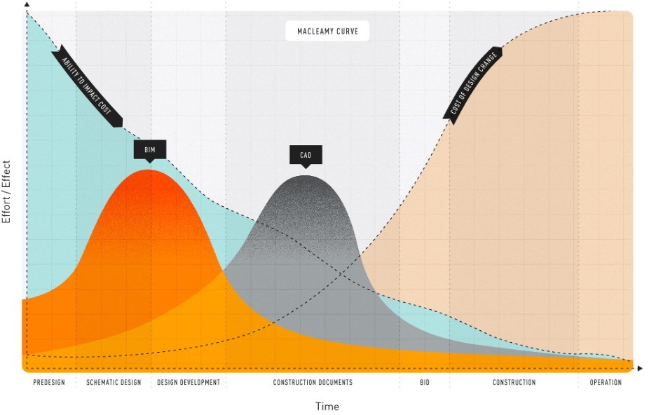
Image: Vectorworks
BIM by its very nature is a collaborative process — and another notable incentive for embracing it is working concurrently with architects, engineers, and other collaborators. By sharing files and data with each other, you can act upon conflicts early in the design process rather than later when revisions are more complicated and costly.
Strategy #2 – Have a Plan and Stick to It
Having a plan is half of the battle, as most transitioning firms can attest. An adopter himself, Roberto Ares of Ares Landscape Architecture shares that a BIM implementation plan is important — even necessary — to find success.
Many landscape architecture firms that have transitioned to BIM workflows did so because of a request by a collaborating architect or other planning partner. Part of your plan could include understanding the ins and outs of IFC and how collaborating architects work with it.
Whether you’re invited to participate in BIM by a project partner, mandated by local ordinances, or if you’re pursuing it yourself to advance your business, develop a plan that digs into your current design software usage, what you’re seeking from BIM, and even a timeline for implementation.
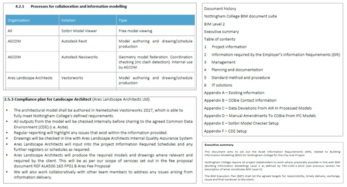
Image: Vectorworks
Strategy #3 – Practice on a Pilot Project
Contributors agree that it’s best not to aim to tackle everything at once when learning BIM. This can be overwhelming, especially if you’re working towards a tight deadline.
Instead, use your BIM Implementation Plan to identify a project whose delivery would benefit from BIM, and initiate the process there. You could do this with an already finished project where it’s just a matter of emulating the design work but incorporating new information modeling strategies.
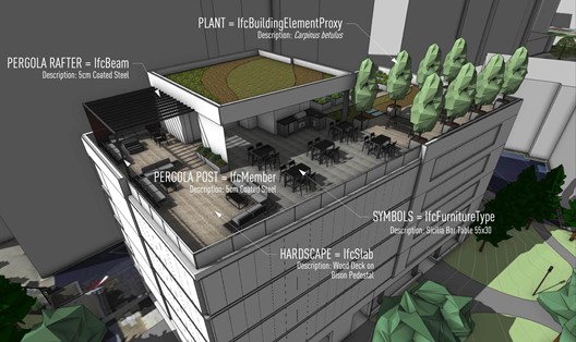
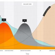
Image: Vectorworks
From there, you take what you learn on each subsequent project and implement it for the next. It’s a continuous learning process as technology develops and efficiency improves.
—
Vectorworks is a sponsor of Land8
Why Multidisciplinary Firm FPCR Chooses Vectorworks Landmark
Collaboration is important in any design discipline, and it’s especially true in landscape architecture, which often requires the input of architects, civil engineers, structural engineers, arboriculturists, ecologists, and more.
It’s not often that this collaboration is handled in-house. Most of the time you’ll see the landscape architecture firm working with external consultants for these design elements.
FPCR, a multidisciplinary UK-based firm, is an exception to this norm. By employing in-house arboriculturists, ecologists, architects, and survey teams, the firm can deliver projects more efficiently than if they were back-and-forth with external stakeholders.
The historically AutoCAD-based office has recently seen a surge in use of Vectorworks Landmark. The software transition is spearheaded in part by the landscape architecture team of 35.
Why Use Vectorworks Landmark for Landscape Architecture?
The FPCR landscape architecture team finds Vectorworks Landmark to be the best software for their workflow, which deals heavily with planting plans.

Masterplan view courtesy of FPCR.
As opposed to other general CAD applications that are best at solving engineering problems, Vectorworks Landmark is purpose-built for the landscape architect — with tools like the Landscape Area tool and the Plant tool, landscape professionals can create detailed, accurate plans much faster than with other software.
For their planting workflows, FPCR considered software options such as Keyscape and CS Artisan. These applications had large plant databases, but Vectorworks offered the team much more than just planting.
That’s the main draw to Vectorworks for FPCR — the all-in-one nature that allows them to take a project from concept to completion without the need to incorporate several additional software programs, which ends up being a huge boost to efficiency.
A direct connection between drawings and reports saves a lot of time in revising multiple documents. An update in one place reflects across all documentation, which is a valuable time-saver when developing a design.
How Do You Collaborate with Vectorworks?
It’s no stretch to say designers must work with a variety of different file formats to accomplish a project. For landscape architects, this will often mean importing and exporting files via AutoCAD, Revit, Civil3D, SketchUp, and more.

Housing layout courtesy of FPCR.
When the FPCR landscape architecture team receives the in-progress DWG files, they typically contain work completed by others. At this point, the site layout is set, and it’s on the landscape architecture team to build out the file with plants, softscapes, and various landscape elements.
Vectorworks Landmark can import a large range of file types (.dwg, Revit, IFC, and Shapefiles, to name a few), so FPCR’s workflow is fully supported in the software. It’s as easy as importing a .dwg file and designing over the top of it. Vectorworks also supports Shapefiles (.shp), enabling seamless importing of geospatial data to give the site an added aspect of real-world context.
Are Custom Workflows Possible in Vectorworks?
The short answer is “yes,” though FPCR have taken it one step further.
The flexibility of Vectorworks Landmark enables designers to work in the way that’s best for them. Intuitive 2D drawing, robust 3D modeling, and multifunctional dedicated landscape tools mean designers can customize their workflow to what works best for them and the project.
In developing their workflows FPCR found that Vectorworks’ Hedge tool couldn’t specify and measure mixed hedge rows properly.

2D mixed hedgerow courtesy of FPCR.
Working in-house, FPCR coded their own Hedge tool. Their custom tool can specify and measure mixed hedge rows by linear meter instead of by area, which is a much more accurate way to specify mixed planting rows. The tool is such an asset to professionals in the landscape trades that Vectorworks, Inc. is set to release the tool into Vectorworks Landmark in a service pack update to version 2022.

The interface for FPCR’s Hedge tool, which can specify mixed hedgerows by linear meter.
The firm has also worked with Vectorworks, Inc. to incorporate additional functionality to the Existing Tree tool, which they wanted to be able to import large groups of trees instead of individual ones, a crucial workflow for the survey and arboriculture teams which would allow them to switch from AutoCAD.
Time Is Money!
The adage certainly rings true in landscape architecture. Intuitively, the speed with which a firm can deliver a project correlates positively to the number of projects they can take on.
It’s why efficiency is such a popular topic, with designers searching for the fastest way to do their work while still maintaining quality standards. FPCR’s case demonstrates how a software built specifically for landscape architecture and design yields big efficiency gains.
—
Vectorworks is a sponsor of Land8.


