


Author: Land8: Landscape Architects Network


Potsdamer Platz in Berlin Becomes a Sustainable Ecofriendly Urban Square
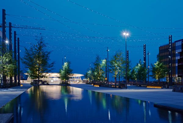
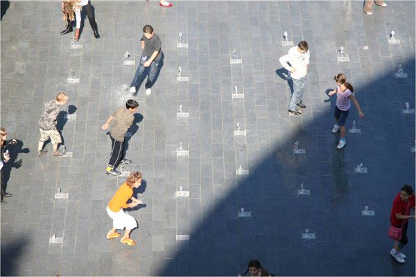
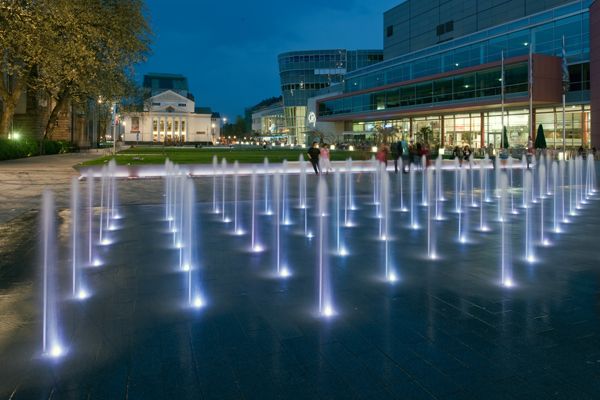
Potsdamer Platz, Berlin, Germany, by Atelier Dreiseitl. It sometimes seems that our contemporary planning is an unholy game of piling as much structure as possible in one spot. The urban spaces about which we brag are often merely the densest piles of bricks, stones or mortar with raised planting beds and seating being converted to mere showpieces. But, where in these heaps and stacks of masonry are the slightest considerations to restore ecological balance? Are the people for whom these are designed refreshed, inspired, and stimulated by their urban environment? Hardly, too often will be the answer for our times. Potsdamer Platz, Berlin, Germany designed by Atelier Dreiseitl is an award winning waterscape project where it combine sustainable water consumption and recreational areas in such a way that water environment issues become perceptible for the city’s citizens and visitors. In addition to the ecological benefits, the water system has cultural and artistic significance. This draws people to the plaza to relax and engage in the water in the realm of the highly dense commercial area.

Potsdamer Platz. Photo courtesy of Atelier Dreiseitl.
Potsdamer Platz
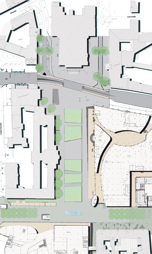
Potsdamer Platz had been an important square and intersection in Berlin since the 20th century. The Berlin wall which separated East and West Berlin and later came down in 1989 gave him the idea to plan an iconic plaza which can heal the old wounds left behind by the wall and can symbolize the reunion of the city. Functional and artistic Significance Today the witness to the history holds the headquarters for multinational corporations like Sony and Daimler Chrysler, along with theaters and a large mall. To keep up with the constricted downtown area, the design team could stipulate that they had to come up with something out of the box.

Potsdamer Platz. Photo courtesy of Atelier Dreiseitl.
- Beautiful Plaza Celebrates Canadian Landscape
- Perez Art Museum Embraces the Landscape Inside and Out
- Ceramic Museum and Mosaic Garden

Potsdamer Platz. Photo courtesy of Atelier Dreiseitl.

Potsdamer Platz. Photo courtesy of Atelier Dreiseitl.

Potsdamer Platz. Photo courtesy of Atelier Dreiseitl.

Potsdamer Platz. Image courtesy of Atelier Dreiseitl.
Scenic Values at Potsdamer Platz
Streams, water bodies are like punctuation marks in reading the landscape. Here, the water is brought out in shallow flow steps that create a shimmering surface of rhythmic waves. People can rest along the water edges or cross the banks on stepping stones over the expanse of water. The sounds of water evoke a sense of pleasure amidst the humdrum of the bustling commercial area.

Potsdamer Platz. Photo courtesy of Atelier Dreiseitl.

Potsdamer Platz. Photo courtesy of Atelier Dreiseitl.
- Urban Design by Alex Krieger
- The Urban Design Handbook: Techniques and Working Methods (Second Edition) by Urban Design Associates
Article by Farah Afza. Return to Homepage
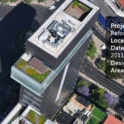

Terrazas Reforma 412 Forms Spectacular Terraces up to 130 Metres above Ground
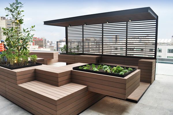
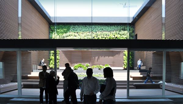
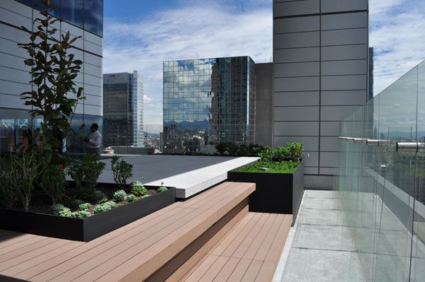
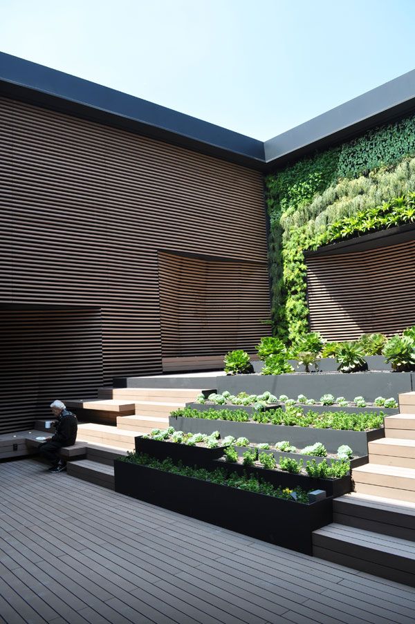
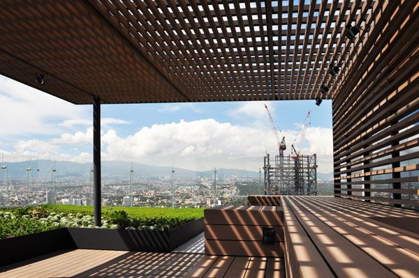
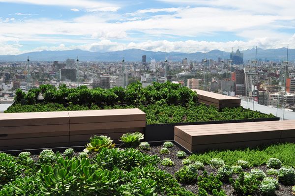
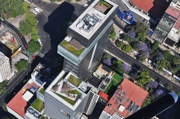
Terrazas Reforma 412, by dlc Architects, Mexico City, Mexico. The largest metropolitan area in the western hemisphere – in short: Mexico City – has grown many skyscrapers during past years. However, one special building called Tower Reforma Diana needs to be mentioned particularly. It was completed in 2013 and comes up with multiple, surprisingly stunning rooftop gardens that feature a marvellous use of composite wood and surfaces covered with greenery. Due to very specific requirements and three different height restrictions this avant-garde complex is formed out of three different cuboid bodies that appear to be moved from their original place. Within the conceptual each of those elements provides minimum one garden-terrace on top, which are: “created to be human” and designed to “live architectural spaces” as the architects say.

Terrazas Reforma 412 visualizations courtesy of dlc architects
Terrazas Reforma 412
Every terraces audacity manifests through intersecting volumes of bamboo-plastic-composite (BPC), a material which we know from previous projects of dlc architects. The various shapes and forms of the sustainable BPC at the multiple terraces of Reforma 412 range from shadow elements to bench-planter-combinations to remarkable wall surfaces. Those various components are decorating every terrace with unique design. Nowadays composite wood is still an underestimated material in Landscape Architecture.

Terrazas Reforma 412. Image courtesy of dlc architects
Terrazas Reforma 412. Image courtesy of dlc architects
Reforma 412. Image courtesy of dlc architects
Terrazas Reforma 412. Image courtesy of dlc architects
Terrazas Reforma 412. Image courtesy of dlc architects
Terrazas Reforma 412. Image courtesy of dlc architects
Terrazas Reforma 412. Image courtesy of dlc architects
Terrazas Reforma 412. Image courtesy of dlc architects
- Urban Design by Alex Krieger
- The Urban Design Handbook: Techniques and Working Methods (Second Edition) by Urban Design Associates
Article by Sophie Thiel. Return to Homepage


The Incredible Hyllie Plaza is Lit by a Digital Sky
Hyllie Plaza, by Thorbjörn Andersson with Sweco architects, Malmo, Sweden Hyllie is situated on the outskirts of Sweden’s third-largest city, Malmö. Because of the new bridge linking it with Copenhagen, some say Malmo is also the second-largest town in Denmark. In recent years, Malmö has taken advantage of the new connection with Denmark’s capital and has started to develop the infrastructure even further. Hyllie Plaza, a city square developed along the new expanded infrastructure, is designed as a minimalist urban beech forest. But how can this emblematic tree thrive in a concrete plaza? No fewer than 28 trees have been planted in 12 slits cut into granite and concrete.

Hyllie Plaza. Photo courtesy of Thorbjörn Andersson
Hyllie Plaza
First of all, what the designer aimed to create through this project was identity. In Skåne — Sweden’s southernmost province, of which Malmö is the capital — the beech (scientific name, Fagus) is an emblematic tree. But the real challenges come from the aesthetic and ecological requirements that can’t be met in an artificial context. A Planting Bed of Stones, Soil and Mulch to Support the Trees To provide the best conditions for the sensitive beech trees to thrive in an artificial environment, a gigantic planting bed has been designed under the square. The planting bed contains different layers of mulch, stones, and a mix of pumice and mycorrhiza soil. The mix of soil is characterized by a great capacity to retain water, because the pumice is a petrified lava ash and mycorrhiza is a mushroom that helps the trees absorb nutrients.

Hyllie Plaza. Photo courtesy of Thorbjörn Andersson
- How The Fish Market Plaza Revamped This Forgotten Site
- Sjövikstorget Square: Traditional Techniques in Modern Landscape Architecture
- Discover the Ancient Secrets of the Physic Garden
The planting bed is covered by what every visitor can see — a pedestrian granite floor measuring 12,000 square meters. To achieve the best results, the trees for this project were imported from Germany, the lava stone was brought in from Iceland, and elements from the water decoration were designed and created in Norway.

Hyllie Plaza. Photo credit: Nikl Ödmann

Hyllie Plaza. Photo credit: Kasper Dudzik

Hyllie Plaza. Photo courtesy of Thorbjörn Andersson

Hyllie Plaza. Photo credit: Åke Eson
- Urban Design by Alex Krieger
- The Urban Design Handbook: Techniques and Working Methods (Second Edition) by Urban Design Associates
Article by Diana Ispas Return to Homepage

How Umeå Campus Park is Closing the Gap Between Work and Nature
Umeå Campus Park, by Thorbjörn Andersson with Sweco architects, Umeå, Sweden. Umeå Campus is the focal center of Umeå University in Sweden. The majority of the university’s courses and programs are held in the buildings and facilities of this 23,000-square-meter campus near the coast, approximately 300 kilometers south of the Polar Circle. Umeå University was founded in 1965 and is Sweden’s fifth-oldest university. The campus has about 35,000 international and multicultural students, teachers, and researchers from all over the world.

Umeå Campus Park. Photo courtesy of Thorbjörn Andersson
Hyllie Plaza. Photo credit: Åke Eson
Umeå Campus Park
This project is the result of a competition held in 2007; it was completed in 2011. The new Umeå Campus Park takes place around an artificial lake, with sun decks, jetties, open lawns, walking trails, and terraces. Here, visitors and students can be part of the landscape, a natural space molded by the architects; the hills and the birch trees create a unique atmosphere that’s rarely common but yet very well designed.

Umeå Campus Park. Photo credit: Åke Eson

Umeå Campus Park. Photo courtesy of Thorbjörn Andersson

Umeå Campus Park. Photo courtesy of Thorbjörn Andersson

Umeå Campus Park. Photo credit: Åke Eson

Umeå Campus Park. Photo courtesy of Thorbjörn Andersson
- How The Fish Market Plaza Revamped This Forgotten Site
- Sjövikstorget Square: Traditional Techniques in Modern Landscape Architecture
- Discover the Ancient Secrets of the Physic Garden
There are no excuses to not bring nature into our common life, like the architects vision, our environment should be as natural as possible; “Natural” not only in the ambient way, but “Natural” also in the way users can feel comfortable, every activity or labor should work without efforts and every path or area should provide people a reason to stay a little bit longer. When I refer to “nature” I do not only mean green spaces, I also refer to clean, stylish and elegant places where we can feel free.

Umeå Campus Park. Photo courtesy of Thorbjörn Andersson

Umeå Campus Park. Photo courtesy of Thorbjörn Andersson
- Urban Design by Alex Krieger
- The Urban Design Handbook: Techniques and Working Methods (Second Edition) by Urban Design Associates
Article by Tahío Avila Return to Homepage

Baan Krung Thep Kritha Turns Flooded Area into Dynamic Landscape
Baan Krung Thep Kritha, by Landscape Architects 49 Limited, in Bangkok, Thailand. It takes an amazing talent and a generous amount of tenacity to take a flooded area and transform it into a beautiful landscape. The project in this case is Baan Krung Thep Kritha, and it is a clear demonstration of how talented the team from Landscape Architects 49 Limited actually is. Completed in 2006 and covering an area of 15 rai (24,000 square meters), this project transformed from a flooded area in Bang Kapi (Bangok, Thailand) to a space that is defined by elegance and perspective.

Baan Krung Thep Kritha. Photo credit: Landscape Architects 49 Limited
Baan Krung Thep Kritha
From Concept to Reality One of the most exciting parts of a landscape architecture project such as this one is taking the ideas one has on paper and transporting them into reality. The team at Landscape Architects 49 Limited managed to take their concept and make it even more spectacular in the real world. It all started with the idea that the internal level should be two meters higher than the surroundings; in doing that, the architects followed the requirements of the client, making the property look as if it was placed on a small hill.

Baan Krung Thep Kritha. Photo credit: Landscape Architects 49 Limited

Baan Krung Thep Kritha. Photo credit: Landscape Architects 49 Limited

Baan Krung Thep Kritha. Photo credit: Landscape Architects 49 Limited

Baan Krung Thep Kritha. Photo credit: Landscape Architects 49 Limited

Baan Krung Thep Kritha. Photo credit: Landscape Architects 49 Limited
The planting at Baan Krung Thep Kritha
The selection of plants is amazing, with the tropical rainforest serving as a source of inspiration. However, the plants and the trees that remind one of the tropical rainforest seem to have integrated very well within the climate of Thailand and this specific area in particular. Moreover, the plants have been chosen to ensure easy maintenance while delivering a natural feeling. The plants are spread throughout the entire property, blending in with other elements in the landscape in the most natural manner

Baan Krung Thep Kritha. Photo credit: Landscape Architects 49 Limited

Baan Krung Thep Kritha. Photo credit: Landscape Architects 49 Limited.

Baan Krung Thep Kritha. Photo credit: Landscape Architects 49 Limited

Baan Krung Thep Kritha. Photo credit: Landscape Architects 49 Limited

Baan Krung Thep Kritha. Photo credit: Landscape Architects 49 Limited
- Urban Design by Alex Krieger
- The Urban Design Handbook: Techniques and Working Methods (Second Edition) by Urban Design Associates
Article by Alexandra Antipa Return to Homepage

5 Slope Protection Hacks for Landscape Architects
Effective ways to deal with a potential slope disaster. Do you ever think about how difficult it is for a landscape architect to plan and design a really contoured site or landscape? Imagine the worst thing that can happen when a high number of steep slopes remain bare and unprotected: High-intensity erosion caused by rain or wind and the unbearable load of the structure above can cause a landslide at any time, destroying everything in its path. Preventing a landslide can be a bit of a challenge. Protecting the slopes would be the first idea for dealing with a situation like this. So, what can we do to protect a slope? Here are some slope protection hacks for you to use if you are facing a possible erosion problem. 1. Vetiver grass (Chrysopogon zizanioides) Chrysopogon zizanioides, well known as Vetiver grass, may be the biggest breakthrough in soil and water conservation in the past few years. The use of a Vetiver grass system can effectively — and at low cost — protect slopes, stop or significantly reduce the risk of slippage, and prevent downstream water contamination. This is because Vetiver grass roots have a high-tensile strength and because when planted on slopes, the grass reduces hydraulic pressure through the removal of water. WATCH: Vetiver: Green Tech for the 21st Century
The combination of slippage prevention (mass wastage of soil) and the grass’ sediment-filtering ability results in very clean water moving down the catchment. Vetiver grass as been applied in many places all over the world and is getting a good response. This system not only provides a solution to slope protection and soil conservation, but also provides significant economic, environmental, and social benefits by keeping a sustainable environment, as shown in the diagram below. 2. Geoweb A Geoweb system provides an economical solution to slope and surface stability problems while meeting a wide range of performance and aesthetic requirements. This system can provide a fully vegetated slope surface that otherwise could not support sustainable plant life. WATCH: Geoweb slope protection and perforations
The structure has a variety of infill options, including fertile and rich topsoil for vegetation, aggregates from sand, gravel or even larger size rock, and even using concrete of various strength and surface finishes. Geoweb structures can resist down-slope movement of embankment material and anticipate hydraulic flows, control erosion, and increase vegetation stability on slopes. Related Articles:
- Is Architectural Engineering Paving the Way for New Opportunities in Landscape Architecture?
- Metamorphous: The Constantly Changing Seawall Sculpture
- Lotus Lake Park Sets Precedent for Sustainable Urban Design in China
3. Gabion Old but gold: Gabion structures installation for slope protection may look conventional, but the ability to provide a surface to support plant life and good permeability is just too good to not get attention. Gabion structures have a good flexibility and durability to protect a steep slope.
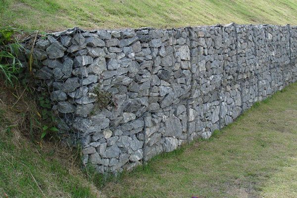
Gabion- corrosion resistant wire containers filled with stone used to build retaining walls, revetments, slope protection, channel linings and other engineering structures. Credit: Eurico Zimbres. Licensed under CC S A 2.5

Retaining wall covered in moss. Credit: CC BY-SA 3.0 , by Fred Hsu
This slurry is applied with pressure to the surface for seed germination and turf development. It gives you a quick, safe, cost-effective, easy-to-apply ground cover, turf, fern, or any other vegetation for your slope’s protection. Which ever way you to decide to adapt your slope, make sure it fits in with the overall scheme of the site, merging with the design, enviornment and long term purpose. For every situation there is a suitable solution. Recommended Reading:
- Principles and Practice of Engineering: Architectural Engineering Sample Questions and Solutions by Mark McAfee
- Standard Handbook of Architectural Engineering by Robert Brown Butler
Article by Harkyo Hutri Baskoro Return to Homepage

Pedreira do Campo Respects the Land and Achieves a Stunning Walkway
Pedreira do Campo by M-Arquitectos, in Vila do Porto, Ilha de Santa Maria. Do you know that one can find thirteen protected areas in Santa Maria, Portugal? Azores, or Açores in Portuguese, is a transcontinental archipelago composed by nine islands that constitute the basic management unit of the Regional Network of Protected Areas of the Azores, as reported by the Government of Azores. Azores is one of the two autonomous regions of Portugal, and it was divided in three geographical groups: the West Group composed by Corvo and Flores (Flowers) Islands, the Central Group that integrates Terceira, Graciosa, São Jorge and Pico and Faial Islands, and the Eastern Group, composed by São Miguel and Santa Maria. An Island With Only 550 People According to Azores Commune, Santa Maria is located in the parish of Vila do Porto and it is the third smallest island of the Azores with a population of only 550 people in approximately 97km² of surface area. Located in Vila do Porto, the Natural Park of Santa Maria was created in 2012, and it was established with no less than thirteen protected areas. One of them is the Natural Monument of Pedreira Campo, where M-Arquitectos implemented a landscape solution as part of an environmental rehabilitation project.

Pedreira do Campo. Photo credit: Artur Silva
Pedreira do Campo
In an unique scenario like the scenario of Açores, in which there is a geological context with extreme scientific importance, there is no doubt that the main challenge that M-Arquitectos encountered was designing a solution that seemed as natural as possible while integrating the intervention project and the island’s nature. Based on this idea, M-Arquitectos suggested a new catwalk, seamlessly integrated with the existing one, allowing visitors a unique view of the island and its natural beauty.

Pedreira do Campo. Photo credit: Artur Silva

Pedreira do Campo. Photo credit: Artur Silva

Pedreira do Campo Sections. Images courtesy of M-Arquitectos

Plan of Pedreira do Campo. Image courtesy of M-Arquitectos

Pedreira do Campo. Photo credit: Artur Silva

Pedreira do Campo. Photo credit: Artur Silva

Pedreira do Campo. Photo credit: Artur Silva
- Beautiful Plaza Celebrates Canadian Landscape
- Perez Art Museum Embraces the Landscape Inside and Out
- Ceramic Museum and Mosaic Garden
The last aspect, but not the least, that makes this solution special is the material used. The catwalk is made of solid wood, which is the perfect choice of material for the intervention. The characteristics of the woods such as color, texture, structure and water content guarantee integration with the surroundings, avoiding an imposed intervention in the natural monument.

Pedreira do Campo. Photo credit: Artur Silva

Pedreira do Campo. Photo credit: Artur Silva

Pedreira do Campo. Photo credit: Artur Silva
- Urban Design by Alex Krieger
- The Urban Design Handbook: Techniques and Working Methods (Second Edition) by Urban Design Associates
Article by Sarah Suassuna Return to Homepage


Designing the Sustainable Site | Book Review
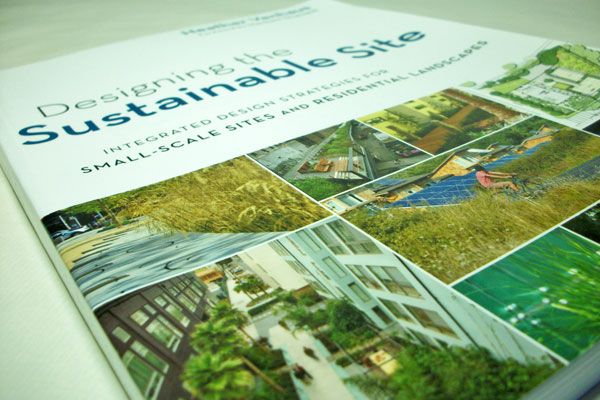
A book review on Designing the Sustainable Site: integrated design strategies for small-scale sites and residential landscapes, by Heather Venhaus; Matt McCaw. At this time, we want to introduce you to a complete, practical guide to facing the challenge of sustainable design beyond simply “doing no harm”. Through a holistic perspective, author Heather Venhaus draws attention to the landscape we are most exposed to: the outdoor small-scale sites we pass by every day. Her wide background working on multidisciplinary teams, always in search of better standards and strategies, was key in her writing of Designing the Sustainable Site. The book takes a look at sustainable design through the lens of experience, offering practical tips and methodology.

Front cover of Designing the Sustainable Site. Photo credit: Elisa
García Nieto
Designing the Sustainable Site
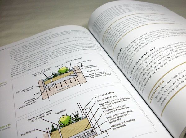
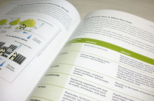
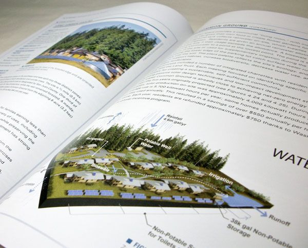
Clues After the First Impression The soft cover, just a bit smaller than A4 format and less than 0.8 inches thick, makes the book ideal for any personal library. There is much information condensed in its pages, however, and even at first sight, Designing the Sustainable Site looks like an easy-to-read piece of writing due to its clean composition and the nice balance between text and graphic elements. In that sense, it is coherent to the visual style that most designers naturally prefer. Just a little note: Although the pages are populated with representative photographs from different projects and the images are involved in the explanation of the ideas in a well-driven way, this is not the kind of book focused on showing a masterwork through graphic documents. You should not expect to find constructive details of alternative solutions. Get it Here! Beyond the Conventional Green One of the aspects really reinforced by Designing the Sustainable Site is the interconnection among different fields and characters involved in the development of sustainability. In fact, the book understands the phenomenon as a big picture, including information about maintenance guides, budget, health, and energy as part of this global point of view.
Inside Designing the Sustainable Site. Photo credit: Elisa
García Nieto
- Landscape and Urban Design for Health and Well-Being
- Digital Drawing for Landscape Architecture
- 10 Books to Read in Your Fourth Year of Landscape Architecture
The Structure One of the main features of this book is its practical orientation. The structure is clear and simple: After brief introductions to different subjects, the readers are soon addressed to design considerations and strategies, pieces of advice, and, finally, real projects that work as case studies.
Inside Designing the Sustainable Site. Photo credit: Elisa
García Nieto
Inside Designing the Sustainable Site. Photo credit: Elisa
García Nieto
Click HERE and pick up your copy of Designing the Sustainable Site. Photo credit: Elisa
García Nieto
Pick up your copy of Designing the Sustainable Site today!
Review by Elisa García Nieto Return to Homepage

The Magic of Foundation Jeantet Produces a Timeless Design
Foundation Jeantet by Agence Ter and Domino Architectes, in Genève, Switzerland. What can we consider as mastery in Landscape architecture? Would it be creating places that bring people together by introducing nature in the built environment, is it the most creative way to do that? Or is it the complexity of thought and creativity required by landscape architects to bridge the gap between the diversity and complexity of the built environment? Or to provide a variety of uses depending on the context? I would say an overlay of all the above is required to create a masterpiece of landscape design no matter the scale of intervention. The Jeantet foundation project is a great example of timeless design and mastery of the tools available to landscape architects. How did they achieve it and what was the challenge?

Plan and section of Foundation Jeantet. Credit: ©agenceter
Foundation Jeantet
The aim of the project was to provide a solution to link a newly constructed auditorium beneath an existing residential building to the neo renaissance style Villa Edelstein belonging to the Jeantet foundation. The renovation of the villa and its gardens were part of the call for AgenceTer and Domino Architects. The team of Agence Ter found a creative and inspiring way to connect the two buildings – through a surprising sunken garden hidden from the street view by a rough concrete wall. The first perspective one experiences after crossing the street gate is a bridge going down to what can be associated with the tranquility of a meditation garden. See More Articles Featuring Work from Agence Ter:
- Aqua Magica Park: The Dark Magic of Ephemeral Experience in Landscape Architecture
- Urban Jungle Created to Perfection by Agence TER
- König-Heinrich Platz Averdung Shows us All That Keeping it Simple is the Best Policy
The 15 by 15 meter garden is surrounded by 4 and a half meters of concrete walls made of thin blocks, providing access to the adjacent new auditorium located on that underground level but also to the renaissance villa on the ground level. Two narrow staircases give access from the Villa to the “horturs conclusus” or the enclosed garden, designed for only one person to be able to go down at a time.

Foundation Jeantet. Credit: ©agenceter

Foundation Jeantet. Credit: ©agenceter

Cherry trees at Foundation Jeantet. Credit: ©agenceter

Foundation Jeantet. Credit: ©agenceter
Foundation Jeantet, taking us from the ordinary to the timeless
The task to find an appropriate solution to link two extremely different entities in terms of architecture buildings was definitely a challenge. However the solution found integrates an ancient concept with a modern twist with sensitive attention to details revealing a new dimension of the space at every step and angle. This is what takes it from ordinary to timeless.

Cherry trees at Foundation Jeantet. Credit: ©agenceter
- Urban Design by Alex Krieger
- The Urban Design Handbook: Techniques and Working Methods (Second Edition) by Urban Design Associates
Article by Yuliya Georgieva Return to Homepage

König-Heinrich Platz Averdung Shows us All That Keeping it Simple is the Best Policy
König-Heinrich Platz Averdung, by Agence Ter, in Duisburg, Germany. In the heart of the city of Duisburg, Germany, lies a large, grassy, park space in front of the theater. The König-Heinrich square is a busy gathering place for the city’s residents, made even more popular by the addition of a shopping center, casino, and pedestrian street right next to Konigstraat. It became necessary to rethink this public space in light of the new uses, while maintaining its urban park appearance. Thus, the French landscape architecture firm Agence Ter proposed a project inspired by the existing green space, claiming that the development of a wide lawn would not be a hindrance in making the square a central site for the city. Instead, a simple lawn can provide a meeting place where everyone can settle as he wishes.

König-Heinrich Platz Averdung. ©agenceter
König-Heinrich Platz Averdung
In addition, the Ter team noted that having a vast green expanse in the heart of a post-industrial city as dense as Duisburg is currently a luxury. Indeed, this space will preserve open space in the city and offer benefits to insects, small animals and, of course, human visitors. For all these reasons, it was important to preserve this green and open space. A Simple But Effective Design Agence Ter has created a project with a wide expanse of grass on which people can relax. The project consists of a game between the mineral, vegetation (which covers a large part of the site) and water jets that animate the central space. Some crocuses were planted in the lawn to color the grass in spring.
König-Heinrich Platz Averdung. ©agenceter
König-Heinrich Platz Averdung. ©agenceter

König-Heinrich Platz Averdung. ©agenceter

König-Heinrich Platz Averdung. ©agenceter

König-Heinrich Platz Averdung. ©agenceter
- Aqua Magica Park: The Dark Magic of Ephemeral Experience in Landscape Architecture
- Urban Jungle Created to Perfection by Agence TER
The redesign maintained the function of the earlier basic green space while adding new points of interest and improving function. This project shows us once again that sometimes the simple things are the most popular.
König-Heinrich Platz Averdung. ©agenceter
- Urban Design by Alex Krieger
- The Urban Design Handbook: Techniques and Working Methods (Second Edition) by Urban Design Associates
Article by Alexandra Wilmet Return to Homepage

Getting Started with ArcGIS and Some Important Things a Landscape Architect Should Know
A beginners guide to ArcGIS and some important things a landscape architect should know about it. Geographical Information System (GIS) is a great aid to landscape architectural works, especially for meso- and macro-scale projects such as town and regional planning. GIS helps you capture, store, manipulate, analyze, manage, and present all types of spatial and geographical data in the landscape architectural work flow process. ArcGIS, developed by ERSI, is one of the popular GIS tools used worldwide. ArcGIS helps you when working with maps and geographical information. It is used for creating and using maps, compiling geographic data, analyzing mapped information, sharing and discovering geographic information, using maps and geographic information in a range of applications, and managing geographic information in a database., Its quick, effective, and accurate tools come in handy in many spatial analysis processes. WATCH: ArcGIS10 Basics 1 of 4 (Make a note of this video and watch it after reading the article and get started with the basics)
Getting Started with ArcGIS
ArcGIS is a really useful tool for a landscape architect, but sometimes it is really frustrating to use this software if you haven’t mastered it yet. But don’t worry: In this article, I want to share with you some tips to getting started with ArcGIS and a few important basics to know. Know the Formats There are lots of data formats used in ArcGIS. Each format is unique and has a specific use. Pay attention to maps, images, features, and any other data you use for your analysis and the format of the output data. You will get used to this after several times using ArcGIS and find the best data format for every work you do. Related Articles:
- Top 10 Hints & Tips For SketchUp
- Computer Aided Software for Landscape Architects: The Essential Guide
- 3D Modeling Software for Landscape Architects
Know the Shortcuts There are surely lots of tools and toolbars in ArcGIS. Shortcuts will save you time! Never hesitate to learn how to use shortcuts, as that will become really helpful later. You can look at list of shortcuts from ArcGIS or on the ESRI web, or you can get many other helpful time-saving tips on the forum on the Internet. Bonus Video: Basic Digitization in ArcGIS
Learn From Other People’s Work ESRI has compiled all GIS works, projects, and research from all over the world. Learn from it! It’s a free database you can use to look for research that can help you finish your project, so why not? Set Your Coordinates First! Make sure you have set all the maps to coordinate correctly before you start your work. It’s the key to starting a project, because the analysis tools and process won’t work if the data and maps you use aren’t configured correctly. Learn about the “Datum system” to know how to project your data and maps with a correct coordinate system and geographical information — you can find this information from many free sources on the Internet. Be Clean: Save Your file Briefly and Clearly The GIS process is about how you analyze, process, and compile various spatial information and serve it efficiently for your uses. It is very important to save all your input and output data briefly so that you can easily look for it when you need it later. Saving your data and work in a brief and specifically named file or folder will be really helpful for later uses of your work. The more informative the file and folder name, the more it will be helpful for you, your client, and anyone who references your work. Bonus Video: ArcGIS 10 – Calculate Area and Volume of a Reservoir
Recommended Reading:
- SketchUp 2014 For Dummies by Aidan Chopra
- The Complete Guide to Blender Graphics, Second Edition: Computer Modeling and Animation by John M. Blain
Article by Harkyo Hutri Baskoro Return to Homepage Featured image: “GvSIG – GIS” by Emilio Gómez Fernández – Own work. Licensed under CC BY 2.5 via Wikimedia Commons

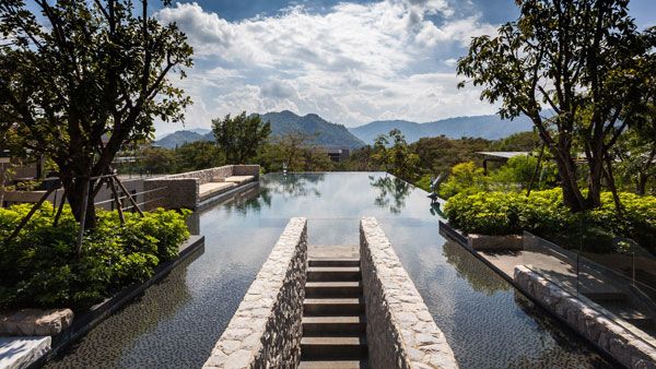
Botanica Khao Yai, an Amazing Blend Between Nature and Architecture
Botanica Khao Yai, by T.R.O.P: terrains+open space, in Khao Yai, Thailand. Nature has always served as inspiration for architectural projects and Botanica Khao Yai is the best example that can be offered. In creating this unique landscape, the architects working on the project have borrowed elements from nature, using Khao Yai, one of the largest rain forests in the entire Thailand, as inspiration. Architecture has the power of creating amazing things, with nature serving as a supreme source of inspiration. This project was based on the natural landscape surrounding the area, on the quality of sunlight and also on the elements of forest. In the end, the final result can be presented as a blend between nature and architecture, with residents enjoying its unique features.
Botanica Khao Yai. Photography credit: Spaceshift Studio Pirak Anurakyawachon, Aranyarat Prathomrat
Botanica Khao Yai
From Abandoned Land to Inspiring Creation From the start, it should be mentioned that Botanica Khao Yai is closely located to Khao Yai, a renowned Thai rain forest. The original site of the project was once an agricultural land, being abandoned with the passing of time. The site is bordered by a local road in the front part and by a small mountain in the back. The originality of the project is given by it being separated into two main plots; the front plot is the one closely located to the road, being designed for residential usage, while the back plot is the one next to the small mountain, being designed as a public park and an area that welcomes both residents and visitors.

Botanica Khao Yai. Photography credit: Spaceshift Studio Pirak Anurakyawachon, Aranyarat Prathomrat

Botanica Khao Yai. Photography credit: Spaceshift Studio Pirak Anurakyawachon, Aranyarat Prathomrat

Botanica Khao Yai. Photography credit: Spaceshift Studio Pirak Anurakyawachon, Aranyarat Prathomrat
- The Garden of Hilton Pattaya by TROP : terrains + open space
- Where Zen Garden Design Meets Enchanted Woodland: TROP’s Forest and Pool at Pyne
- Sky Pool Takes World Class Design to the Next Level

Botanica Khao Yai. Photography credit: Spaceshift Studio Pirak Anurakyawachon, Aranyarat Prathomrat

Botanica Khao Yai. Photography credit: Spaceshift Studio Pirak Anurakyawachon, Aranyarat Prathomrat

Botanica Khao Yai. Photography credit: Spaceshift Studio Pirak Anurakyawachon, Aranyarat Prathomrat

Botanica Khao Yai. Photography credit: Spaceshift Studio Pirak Anurakyawachon, Aranyarat Prathomrat

Botanica Khao Yai. Photography credit: Spaceshift Studio Pirak Anurakyawachon, Aranyarat Prathomrat
The Hidden Dining Pavilion at Botanica Khao Yai
Among the most interesting things that you will discover here, there is the Dining Pavilion, elegantly hidden by a beautiful bamboo forest. The surprises continue with the green hill that was easily integrated into a reflected pond and the two swimming pools. On the right side of the park, there is a jogging track that can be used by both residents and visitors. There is also an elevated jogging bridge, which guarantees more than one route option for those who use it.

Botanica Khao Yai. Photography credit: Spaceshift Studio Pirak Anurakyawachon, Aranyarat Prathomrat

Botanica Khao Yai. Photography credit: Spaceshift Studio Pirak Anurakyawachon, Aranyarat Prathomrat

Botanica Khao Yai. Photography credit: Spaceshift Studio Pirak Anurakyawachon, Aranyarat Prathomrat

Botanica Khao Yai. Photography credit: Spaceshift Studio Pirak Anurakyawachon, Aranyarat Prathomrat

Botanica Khao Yai. Photography credit: Spaceshift Studio Pirak Anurakyawachon, Aranyarat Prathomrat
- Urban Design by Alex Krieger
- The Urban Design Handbook: Techniques and Working Methods (Second Edition) by Urban Design Associates
Article by Alexandra Antipa Return to Homepage