It’s no secret that climate change is a hot topic right now. Due to recent megastorm events, climate change has become a central focus in many professional circles. Within the design realm, Hurricane Sandy’s destruction in 2012 spawned a focus on exhibits in New York City that predicted devastating repercussions if preemptive infrastructural measures were not considered, such as the Rising Currents at the MoMa in 2010. While the exhibits in New York helped spur more discourse about climate change in a design framework, equally vulnerable cities were left out of the discussion.
Enter four budding professionals from the Boston area-based design and planning firm Sasaki Associates. This small group of spirited, driven designers and planners developed a personal research passion into a well-publicized public exhibit. Over the course of the past year, Nina Chase, Ruth Siegel, Chris Merritt and Carey Walker have combined their shared interests concerning sea level rise to produce an exhibit at District Hall in the Seaport District of Boston. Prior to the installation of this exhibit, the group used their sea level rise research to lead the annual internship program at Sasaki, spearhead an important planning document for the city City of Boston, teach students at the Boston Architectural College, garner work for their firm’s urban design and planning studio, and host of series of lectures and discussions about this important topic. The following interview details how these motivated design professionals began a year-long process with a passionate idea in mind which resulted in a lot of far-reaching results…with more to come!

1. First, congratulations on designing, planning and showcasing a fantastic exhibit! Can you please explain how the exhibit work first began, and how it developed into such an elaborate and involved endeavor?
NC: The topic of sea level rise was of personal interest to all of us. After Hurricane Sandy hit, we realized there was a lot of discussion about climate change in the design community of New York, but not as much going on in Boston. But then in February 2013, TBHA (The Boston Harbor Association) put out their Preparing for the Rising Tides report, which was the first time that people could see where flooding was projected to occur in Boston and it sparked a whole series of mini conferences about the subject. We thought that it would be a good time to insert ourselves as leaders in that conversation.
RS: There were a lot of symposia and lectures that were mostly people from New York talking about Hurricane Sandy. We were attending a lot of these events because we were interested in the topic, then we started talking about how there was no local design firm leading the discussion about what’s happening in Boston with respect to designing for sea level rise. So we saw that as an opportunity.
NC: Next we started talking about the research opportunities about sea level rise at Sasaki and we pitched it as an in-house research project. Urban Fabric had happened a few years ago and that was something we wanted to emulate – the model of research in professional practice and bridging the gap between what we were doing in school and how we are practicing. Urban Fabric was really an inspiration – we used that model and pitched the idea of sea level rise as the topic and Boston specifically as the location.
RS: That was something that was exciting me about Sasaki as a potential employee. We were just starting as employees and wanted to do something important and meaningful, not just for ourselves, but for the firm. We are very lucky to have such supportive leadership who saw potential in this idea and encouraged us to pursue it.

2. On a side note, how has this research work parlayed into actual work for the firm?
NC: The crazy thing is that it’s been in tandem – at the same time that we have been doing the research for Sea Change, opportunities have been coming up for the firm through the Sea Change work like marketing the initial research we had done. We packaged it roughly and used the graphics, methodology and framework for what we submitted for Rebuild By Design competition this past August. We are also partnering with TBHA on their next report, which is focused on design strategies as they relate to sea level rise.

3. How did your successfully pitched research ideas about sea level rise transpire into the main topic for Sasaki’s internship program last summer?
CM: Typically the internship charette works with an existing or prospective client and a few in-house people lead a local studio-like project. There wasn’t an idea fully formed yet for that year’s program and we had started this research so it was perfect timing.
NC: Our research already had us thinking at a larger scale of Boston, so we thought the interns could zoom in even further to South Boston (#SummerofSLR), and the Boston Architectural College studio (#SemesterofSLR) in the fall could focus on East Boston. It was nice because our core team focused on the larger scale research and the interns and students focused on site-specific ideas. Coming from students, it was easier to be provocative, not being confined by clients’ expectations and financial limits. RS: We have hovered at a slightly abstract level of design because it’s a highly controversial topic. We as a firm, didn’t want to say “this is what we should do here” because there are a lot of ways you can design to address the problem.
CM: We also wanted to address the larger regional complex issue of sea level rise without diving into one site saying “this is what we have to do here”. We wanted to give a holistic approach or an idea about a strategy to approach sea level rise for the Boston metropolitan region.
.(Related Story: 5 Resiliency Lessons from NYC Stormwater Projects)

4. In order to reach a broad audience, and not just designers and planners, what were some of the graphic techniques that you found most helpful to use?
NC: We had a really amazing graphics team at Sasaki that worked with us to help us focus the storytelling and the brand to make it so that we could introduce huge concepts but bring them down to a level that could be easily understood. There was also a lot of writing involved, so we had to distill it down.
RS: There were word counts for every board. We wanted to make sure people would actually read it and not get lost in the text, so we had to edit, edit, edit.
CW: This meant that the graphics really had to stand on their own.
NC: One of the cool things about the branding strategy was that the title and key points were highlighted like a science textbook.
CM: It was huge to have the graphics team so that we would have someone on hand to think how someone experiences an exhibit and know about placement of images and takeaways.
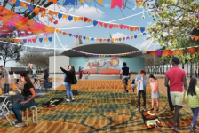
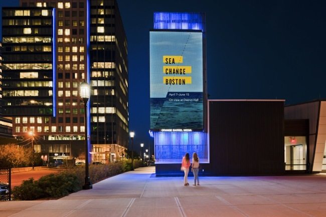
NC: The location of the exhibit was very important. District Hall in the Seaport District had never had hosted an exhibit before and the 4 of us had never done anything like this, so there was quite a learning curve. But since the venue attracts such a diverse audience beyond the design community, we saw it as a perfect venue for getting this work seen by the public. RS: We had to work with the graphics team because the space is not set up as a “proper” exhibit venue. District Hall is set up to be a flexible space, so that had to be built into our exhibit. It turned out to be a great design challenge for us which led to our free-standing “hubs” – we feel these vertical elements really populate the space and create a major presence for the exhibit.
CM: I think just being accessible to the public is the biggest thing. It could have been set up in a beautiful exhibit hall, but it wouldn’t reach as many people.
RS: We also have gotten walk-ins from people visiting the nearby cafe. People have been posting images of the exhibit on twitter and Instagram saying thingslike, “I came in for a cup of coffee and learned all about sea level rise! This is amazing!”
RS: District Hall is also in the flood plain, located in the Innovation District of Boston, which has a lot of development projects currently underway. The 2100 projection of sea level rise hits the second stair outside of the building This was a major opportunity for us to visualize the problem of sea level rise – we literally could say “high tide could be here in 2100 if nothing is done.” Our stair riser flood level graphic was reportedly one of the most powerful components of the exhibit. So simple, yet so effective.

5. What was the most helpful thing that you learned from partnering with other organizations in planning Sea Change events? How do you think these partnerships will benefit the project’s main initiatives? And furthermore, what advice do you have for landscape architects and planners who are interested in reaching a broad public audience with their design initiatives?
NC: The audience that we were able to reach by partnering with THBA and the city were totally different than who we would have reached just through Sasaki or the Boston Architectural College. For us, that was one of the fantastic outcomes – that we were able to reach a broader community.
RS: The variety of people able who were able to come to the opening and symposium was also amazing. There were so many people we didn’t recognize at these events – I kept asking people how they found out about the exhibit, and I got a range of answers, but they all seemed to connect back to the city or TBHA.
CW: Which was exactly what we wanted!
NC: The idea that “climate change is bigger than any one organization” was key. Partnering with a government organization and one of the largest non-profits in the city whose entire mission is about the harbor, and they started the sea level rise conversation initially. We brought a lot of people into Sasaki as part of the intern charette and met with people from the city and TBHA. From the beginning we have been plugging in different experts and that has coalesced into the exhibit and lecture series.
One of the ways we partnered with the city was the Greenovate program, which is about climate change preparedness and engaging with the community to get feedback. They have a question page, “What would you do if sea level rise happened in your neighborhood” which we link to in the exhibit. The addresses that people put in for the interactive feature are being collected so that the city can see the areas that people are worried about.
(Related Story: Landscape Architects Chosen as Finalists for Rebuild by Design Competition)

6. It seems like a lot of efforts in the United States is reactive. It’s not until a Hurricane Sandy happens that there is a response.
NC: That was something that came up at the symposium. Do we need a trigger or can we be proactive and invest proactively.
RS: And that was one of the goals of the exhibit, to wake people up. In this country, the “out of sight, out of mind” response tends to be more accepted than being proactive. But there have been three or four near misses in terms of major storms recently which could have caused substantial damages in Boston.

7. What future goals do you have for Sea Change? Will this be exhibited elsewhere? Published?
CW: I think it’s really important that it’s a continued thing. The problem is not solved and we are just starting this conversation. This exhibit is the first step in reaching the external audiences that need to be reached and the next step is actually doing something.
NC: The ultimate goal was to create a regional plan specific to sea level rise and that conversation has started.
CM: And it’s something that we didn’t even bring up as a marketing thing for Sasaki, it’s something that came up through doing the research, that every city needs to be thinking this way.
RS: It would be fantastic if a regional scale plan would come out of this, no matter who does it. In terms of the exhibit, we have been talking with other interested parties who want to take the exhibit “hubs” and put them elsewhere to be displayed. That is an unintended benefit of these free-standing display “hubs”, that they are transportable and not on a wall. We’d like to do a book, whether or not that’s digital or printed, or both. And we’re talking about the potential for the interactive map that was created to go on the road. As of very recently, our interactive map is now available on the internet and can be viewed on tablet devices.
NC: We’ve just had the interactive map reformatted so that there is a version that is displayed on the huge touch screen at District Hall, and also one that can be used on an iPad or computer.
RS: One final thing is that when we started this process we put a colon in the title with the idea of this could be done in other cities. For example, “Sea Change: Miami”.
CM: Even if we don’t take this and repurpose it and package it for another city, it’s something that can speak to the bigger picture and start an important conversation.
**The Sea Change: Boston exhibit will be on display at District Hall in Boston’s Innovation District until June 13.**
You can also see their full presentation on Slideshare here.
See these links for some of the groups related efforts and projects:
Sea Level Rise exhibit
http://www.sasaki.com/project/360/
Rebuild by Design Design Competition
http://www.sasaki.com/project/335/rebuild-by-design/
Interactive Map
http://seachange.sasaki.com/map/
Greenovate Boston
Sea Level Rise: Boston Sasaki Intern Design Charette
http://issuu.com/sasakiassociates/docs/master_book_executive_summary_for_i
Nina Chase as a panelist at the Boston Society of Architects Event, Troubled Waters: A Public Forum
http://www.architects.org/news/video-troubled-waters-public-forum
Twitter Hashtags:
Participating Groups:
The Boston Harbor Association (TBHA)

Published in Blog