Author: Jason Packenham
Gadget Review: Leica Disto D810 Touch
I was recently given the opportunity to test out the new Leica Disto D810 Touch – a hand held laser distance metre complete with a touch screen and on-board digital camera. Although I have previous experience with the older Leica Disto A5, it it was a good to get my hands on the new model.
Before I reflect on my own experience with the product and comment on its performance and design, let’s kick things off with a brief description of its features:
- As with most other laser metres, the Disto D810 Touch allows for the take-off of straight-line measurements and can generate a number of indirect calculations such as area, volume and hypotenuse.
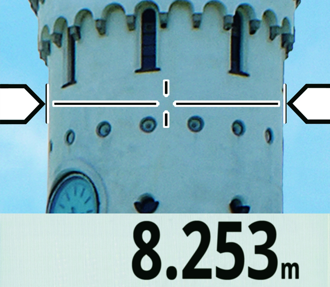
- The device is able to measure up to a distance of 660’ with accuracy of 1/16”, suitable for pretty much any landscape architect’s requirements.
- It also features an on-board camera that allows you to take a photo of an object and measure its dimensions using the touch screen on the device itself. This point and shoot functionality calculates the depth of field in an image and enables real world measurements to be taken from the photos you snap.
Measurements on the photo using the devices touch screen | Leica Geosystems
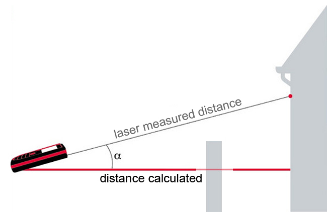
The device’s inclination tracking, Smart Horizontal, ensures the accuracy of indirect calculations and photo measuring. It also allows you to measure the distance of an object even when the perpendicular line of sight is obscured.
Horizontal distance measurement using Smart Horizontal TM
The touch screen is a world first for laser distance metres, and although it’s not quite as quick to navigate through as on a smartphone, it makes menu navigation much easier to use than on previous models.
Leica has also developed the Disto Sketch smartphone app, which allows dimensions to be quickly and wirelessly added to photos, sketches and excel spreadsheets. This allows for quick and accurate on-site takeoffs.
 Disto Sketch smartphone app for adding measurements to photos, sketches and excel spreadsheets | Leica Geosystems
Most of my professional work takes place in the public arena and as such I am often provided with site survey drawings, but I can definitely imagine that landscape architects involved in residential work could save plenty of time using the Disto D810 Touch.
That being said, I took to the backyard in a ‘faux project’, looking to replicate what a landscape architect may do at the beginning of a residential engagement. I found that I was able to quickly and easily produce a dimensioned sketch plan for my yard using the Disto Sketch smartphone app.
 Disto Sketch provides a sketch plan tool for dimensioning your site | Leica Geosystems
One more neat trick I found with the new product was its ‘minimum/maximum mode’, which produces a smart little workaround for human error in the measuring process. All you do is run the laser in an arc shape through your furthest point of measure and it will detect that furthest point and record it as the measurement. I found this useful when measuring irregular corners of my site.
Now, I can imagine some people might be put off by the $849 USD price tag, but if you often find yourself taking on-site measurements then a workflow that combines the Disto D810 Touch with the Disto Sketch smartphone app could save you an hour or two each project. Furthermore, particularly in the case of a D&C firm, the on-site team could measure particular site areas/elements and wirelessly transfer these to the office-based design team, potentially removing the need for additional site visits later in the project. When you consider the cumulative effect of this saving, maybe the price tag is a little easier to digest?
All-in-all, considering the vast improvement on the older model that we’ve got in our office and Leica’s effort to move to a more streamlined digital process, it was a positive experience with the new Leica Disto D810 Touch.
Jason Packenham is a Registered Landscape Architect at Context and design studio tutor in the Bachelor of Landscape Architecture program at the University of New South Wales.
Digitising Landscape Architecture: Rhino in Landscape
Rhinoceros (Rhino for short) is a standalone 3D modelling program that provides a flexible and versatile modelling environment for a variety of architecture, engineering and construction (AEC) industry professionals, from architects to industrial designers; including landscape architects!
Its interoperability, multidisciplinary toolsets, relatively low learning curve (compared to other high-end 3D modellers/renderers) and modest price tag make it quite an attractive option for those looking to incorporate 3D modelling within their design, documentation and presentation workflows.
BIM-enabling modelling as well as technical drawings all within Rhino
What makes Rhino’s modelling capabilities so robust is its use of NURBS geometry. What are NURBS you ask?
NURBS
NURBS (Non-Uniform Rational B-Splines) are mathematical representations of 3D geometry that can accurately describe any shape, from a simple 2D line or curve to the most complex 3D organic free-form surface, solid or mesh. Because of their flexibility and accuracy, NURBS models can be used in any process from illustrative representation to fabrication.
RELATED STORY: Rendering Tutorial – Transparency Maps
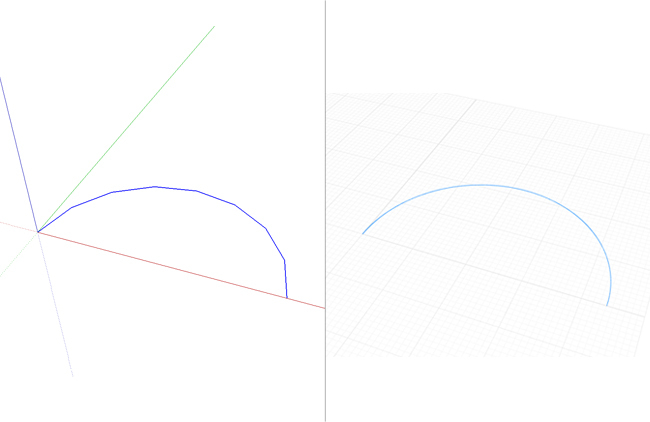
The beauty of NURBS is that less information is required to model a piece of geometry than the amount of information required to model the same piece of geometry using faceted approximations. A good explanation of this above point is illustrated in the following image. Here, we have a faceted SketchUp arc (left) and a smooth Rhino arc (right).
An arc drawn in SketchUp (left) and Rhino (right).
The faceted curve is made up of a number of straight lines – the example above includes eight lines. Sure, this number can be increased, but doing so increases the amount of information required to model the geometry of the curve, and the accumulative effect of this increase in information is poorer hardware performance.
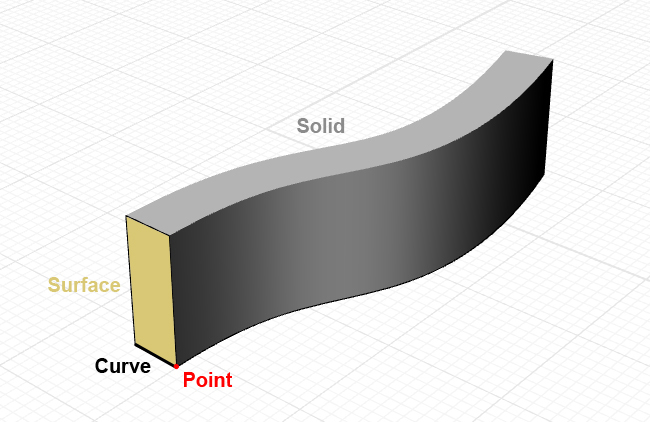
The basics of modelling in Rhino: Points, Curves, Surfaces and Solids.
Interface
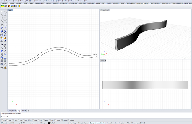
Rhino’s interface allows for multiple views of your model, using viewports that can represent orthogonal and perspective views simultaneously. This allows for accurate orthogonal drafting in plan and elevation views, similar to what you would experience in conventional CAD programs, with the ability to see and switch to your perspective view for a 3D modelling process similar to SketchUp. This also allows you to appreciate what your documentation drawings will look like as you go.
Multiple viewports allows for an accurate yet dynamic modelling workflow.
Plugins
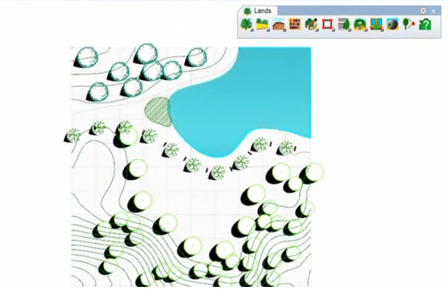
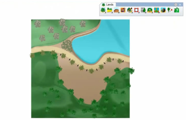
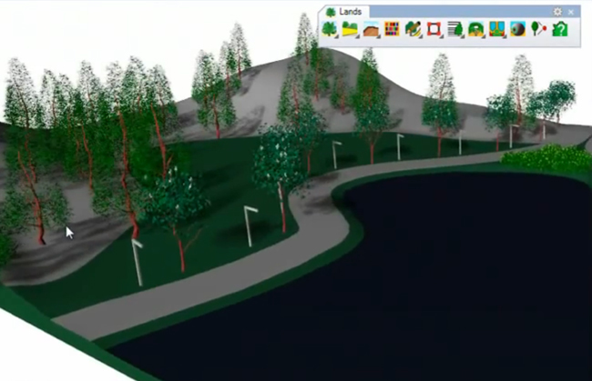
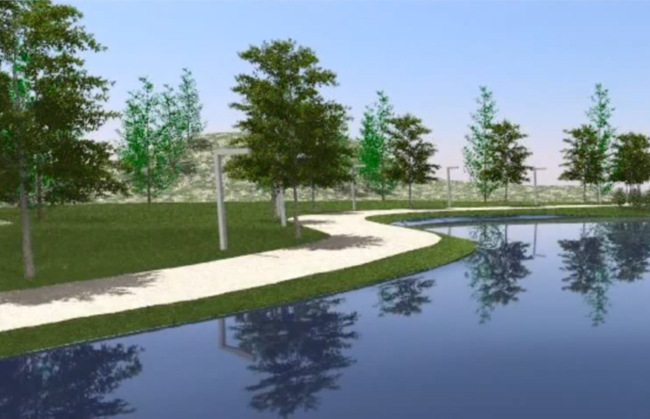
Another fantastic use of Rhino comes with the Lands Design plugin, which offers a number of landscape-specific palettes containing tools for landscape professionals. The terrain tools include the ability to produce a digital terrain model (DTM) as well as import Google Earth terrain and imagery directly into your modelling space, which is great for adding context to your work.
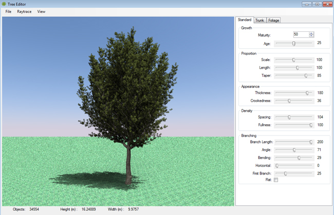
Lands Design’s Plant Editor
Plant tools include BIM enabling plant objects, viewable in 2D entourage in plan and elevation views as well as 3D models for perspective views. These plant objects are linked to a plant database that allows for scheduling of plants for your planting plans. Existing plant models can be modified or new plant models created using the Plant Editor, with everything from growth habit to trunk bark and foliage completely customisable. The plugin also includes a civil palette with path, stairs, walls and fences tools, while other tool palettes include irrigation, urban furniture and documentation.
Orthogonal plan view | Asuni CAD S.A
Rendered plan view | Asuni CAD S.A
Shaded perspective modelling view | Asuni CAD S.A
Rendered perspective view | Asuni CAD S.A
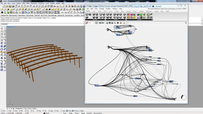
Other plugins that improve the performance of Rhino include Flamingo and V-Ray, which allow for more advanced photorealistic rendering directly from within your Rhino model. Parametric modelling is also enabled in Rhino with the Grasshopper plugin. For those of you who have yet to encounter parametric modelling, I’ll try to succinctly describe it:
Parametric modelling involves the use of parameters and constraints to define the model. Parameters may include dimensions, materials, object assembly points, etc while constraints applied to these parameters can affect their behaviour, for example the width of a retaining wall remaining a particular dimension. There will be a more in-depth look at parametric modelling for landscape architecture using Rhino and Grasshopper in a follow up post by fellow Land8 writer Adam Mekies – an article I’m very much looking forward to!
Parameters are defined in Grasshopper and modelled in Rhino simultaneously | De Ville D’Avray, Grasshopper3D
For me, Rhino sits between the entry-level modeller SketchUp and more advanced rendering programs such as Autodesk’s 3Ds Max. The program enables 2D orthogonal drafting in much the same way that AutoCAD does and combines this with simple surface and solid functions similar to those in SketchUp. I’ve once heard of it described as SketchUp on steroids – and I’d have to agree.
RELATED STORY: 10+ Resources to Enhance your SketchUp Skills
If you are looking for an affordable and robust modelling program that offers more than SketchUp but doesn’t commit you to the often-daunting learning curve of advanced modelling and rendering programs, then Rhino is for you. It has a mind-boggling number of useful features and plugins that enable you to do just about anything, and it’s always nice when some of these cater specifically for us landscape architects.
This article is part of the Digitising Landscape Architecture series. Click here to view other articles in the series.
Jason Packenham is a Landscape Architect at Corkery Consulting and design studio tutor in the Bachelor of Landscape Architecture program at the University of New South Wales.
Digitising Landscape Architecture: Vectorworks Landmark
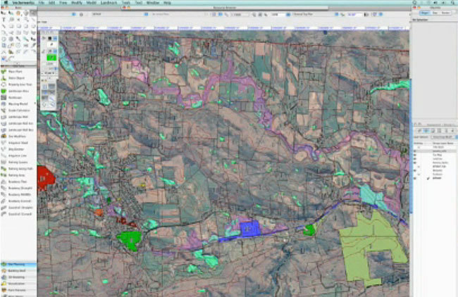
Nemetschek’s Vectorworks Landmark is one of the few standalone BIM-enabling software packages targeted specifically towards landscape architects. In addition to the landscape-specific BIM capabilities that Vectorworks Landmark offers, it also incorporates mapping and GIS functionality as well as interoperability with a variety of building design applications such as Revit and ArchiCAD.
(SEE ALSO: Digitising Landscape Architecture: Revit for Landscape Architects)
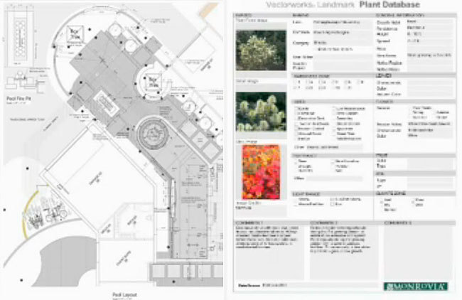
Vectorworks Landmark includes a substantial collection of built-in BIM-enabling intelligent tools such as terrain, plants (in a +8,000 plant database), hardscapes and retaining walls. For example, 2D tree symbols correspond to 3D tree ‘objects’ with all the information pertaining to that tree documented in a database for scheduling, procurement, costing, maintenance requirements and so on.
+8,000 plant database including photos for scheduling and report | Nemetschek Vectorworks
Interoperability is always an essential consideration, particularly when venturing away from the more traditional Autodesk-centric workflows. Vectorworks imports, exports and externally references AutoCAD dwgs (the new external reference capability in the 2014 release is a BIG plus), publishes drawing sets to PDF, imports concept models from SketchUp and exports 3d models to Google Earth. Another obvious consideration is cost. Vectorworks provides in a single program the workflow of AutoCAD, Land F/X and SketchUp.
GIS functionality with importing shapefiles | Nemetschek Vectorworks
For a closer look at the software, I recently caught up with Eric Gilbey, Landscape Architecure Industry Specialist at Nemetschek Vectorworks.
Jason Packenham (JP) – What’s your 2 minute ‘elevator pitch’ to landscape architects looking to adopt a BIM workflow?
Eric Gilbey (EG) – When landscape architects look to adopt a BIM workflow, I would first want them to acknowledge whether they are doing so to model and document proposed changes and amenities for their own Site Information Modeling needs, or if they are doing so to collaborate with BIM clients. In either case, Vectorworks Landmark software can meet their needs. It is the only standalone application that offers integrated 2D/3D information modeling specific to landscape architecture and site design (Site Information Modeling). When collaborating with clients using other BIM applications, this occurs via IFC (data and geometry) and several 3D file formats (geometry only) that allow all design team participants to see and share files to then understand how the site works with the building and its infrastructure.
JP – Vectorworks’ BIM for Landscape Architects brochure details a substantial list of compatible applications, although engineering programs such as Civil 3D and 12D are notable exclusions. Vectorworks’ ability to allow collaboration with architects is well documented, but what capability does Vectorworks have with Civil 3D or 12D (or with LandXML files potentially provided by engineers) for those landscape architects who work closely with engineers on infrastructure projects?
EG – Collaboration with other applications, be they site-specific, 3D modeling, or general CAD, is straightforward when doing so with Vectorworks Landmark software. Civil3D and 12D, both exchange with DXF/DWG, which our software also treats as native geometry. We recommend that users communicate with their design team members about the file type and form of information being exchanged. Then, they can choose the best format to support those parameters. For example, several file format exchanges facilitate the import of site survey data into Vectorworks Landmark, including coordinate points listed in CSV or TXT files, data-rich DXF/DWG points, as well other 3D geometry such as mesh surfaces and 3D contours exported in various file formats. When creating or managing site information models in the software, it is always beneficial for the user to make use of any available 3D source geometry, but the workflows still exist for them to import and convert non-3D objects into a modeled site.
JP – What would you say to the experienced Autodesk-aligned landscape architects who are afraid to make the jump to Vectorworks? And to those users who have looked at Vectorworks in the past and decided against it? Have releases in recent years completed changed the game?
EG – I recently heard a user say, “I really enjoy using Vectorworks for site design. I don’t think I’ve ever heard someone say the same thing about an Autodesk product.” I feel the same way. In fact, before learning Vectorworks Landmark, I had been a long-time AutoCAD user and only designed by hand prior to that. However, once diving into the program, I discovered that Landmark’s site-specific tools were purpose-built for the work that we landscape architects do. It isn’t just a matter of figuring out a new way of laying out a site with lines, shapes, and text, and translating that into elevations or details, creating two or three times the work time involved just to get drawings out the door. Instead, the intuitive tools and hybrid nature of the site objects means less time getting drawings out and more time to move on to the next project. It also means that the objects I’m designing with, such as plants, hardscapes, turf areas, terrain models, etc., help me do a better job at site design because they are the same objects that report to the built-in worksheets, allowing me to analyze, quantify, and present, all within the same CAD application. In addition, Vectorworks had dedicated training and support teams that are available to help with your site-specific workflows.
JP – Vectorworks continues to include additional features and functions within future releases of the software. Are you able to shed any light on what works are in the pipeline for the future of Vectorworks Landmark?
EG – Every module of Vectorworks software sees development, which reacts to our users’ requests and industry trends. Our Landmark module’s future development is a great example of this as our focus will continue to be on developing solutions tailored specifically for landscape architecture and urban planning firms. While I can’t speak to any new features or enhancements specifically, future versions will continue to fundamentally focus on creating a finely tuned, easy-to-use product that continues to deliver best-in-class solutions for graphic representation, site information modeling, and integrated 2D/3D site design and modeling.
Concept graphics | Nemetschek Vectorworks
Batch plotting | Nemetschek Vectorworks
For those who are hesitant to venture away from the Autodesk environment they have been trained in and have operated within their entire careers, Vectorworks will require some time for adjusting, as would be expected. On this issue, there appear to be mixed reports from users both within the Land8 community and across other online forums.
2D drafting and 3D modelling occurs simultaneously | Nemetschek Vectorworks
But I must say, as someone who has previously used Vectorworks Landmark and is now using other CAD software (due mainly to a change in projects I’m involved in), the 2014 release of Vectorworks Landmark looks to have addressed many of my previous concerns with the program, not least of which is the ability to externally reference .dwg files without the need for importing into your drawing. This feature, along with many other new ones, looks promising, and I encourage even those who have previously shied away from Vectorworks to have a look at the 2014 release, and be sure to let us know how you go.
A big thank you to Eric Gilbey and the Vectorworks team for their time! This article is part of the Digitising Landscape Architecture series. Click here to view other articles in the series.
Jason Packenham is a Landscape Architect at Corkery Consulting and design studio tutor in the Bachelor of Landscape Architecture program at the University of New South Wales.
Digitising Landscape Architecture: Get Modelling with InfraWorks!
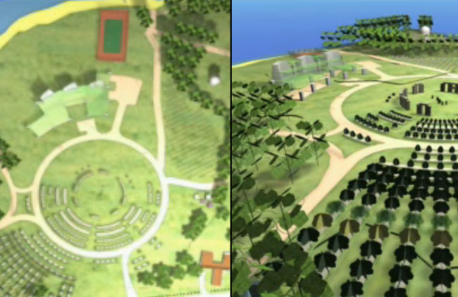
Autodesk InfraWorks is a relatively new program that provides an extremely powerful yet relatively simple 3D visualisation environment for importing and rendering extremely large datasets in real time.
Previously known as Autodesk Infrastructure Modeler, its rebranding perhaps suggests Autodesk’s recognition of the ability of this software to play a much larger role in the architecture, engineering and construction (AEC) industry.
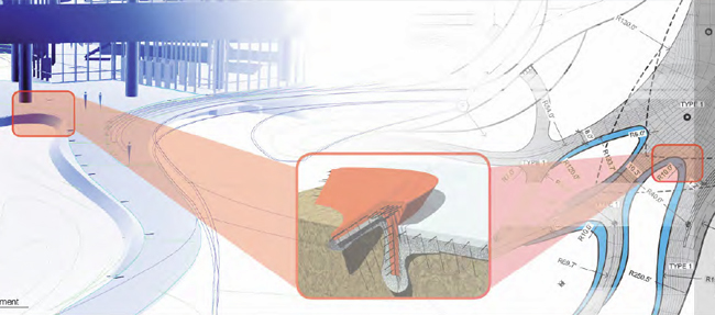
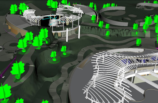
Large datasets are rendered in real time for presentation and analysis | Corkery Consulting
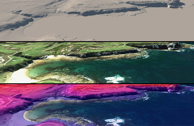
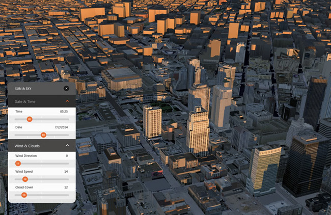
Beginning with the data of existing site conditions, InfraWorks provides a live-rendered virtual environment for importing complex topographic data, high resolution aerial photography, GIS shapefiles, CAD drawings as well as a number of other data types, for synthesising existing site conditions for discussion with clients and project teams. Analysis such as elevation, slope, aspect and shadows can not only be produced in a matter of seconds but also viewed in real time in 3D.
Shadow analysis | Autodesk
Alternative concepts for path and plaza locations, road alignments, areas of mass planting and building massing can be quickly explored via InfraWorks’ built-in modelling tools. Additionally, landscape architects can present and analyse their designs within InfraWorks with the surrounding terrain features, transportation networks, and buildings fully modelled at the block, neighbourhood, city, or regional level.
By sharing a model via InfraWorks 360, models can be viewed in any internet browser, even on computers that do not have InfraWorks installed. This allows landscape architects to share models with clients, stakeholders and collaborating professionals for review. The graphic quality of the online model environment doesn’t quite offer the same high quality rendering, but is still a reasonable tool for quickly sharing your conceptual explorations with clients (who appreciate being involved in the process!).
RELATED STORY: Civil 3D for Landscape Architects
Still renderings can be exported to image files, or the whole model can be exported to LandXML for importing into other modelling programs such as Civil 3D. This allows the conceptual models explored within InfraWorks to be incorporated as the first step in the detailed design phase within other applications. Animated visualisations can also be exported from InfraWorks to video files, although the Storyboard palette required to do so is a little cumbersome.
Analysing sea-level rise using InfraWorks | Corkery Consulting
I’ve always believed landscape architects are great synthesisers of information, able to view the bigger picture when other professionals can become bogged down in their own profession-specific agendas. Not only can InfraWorks form an important part of the workflow of a landscape architect, it can also provide an opportunity for landscape architects to reposition themselves within project teams, acting as synthesisers of multiple disciplines to bring all elements of the project to realisation within a digital environment able to be rendered in real time. This facilitates easier communication between clients, stakeholders, consultants and members of the community.
Even if you feel as though some of the features explained above don’t really relate to your current workflow, I’d definitely keep an eye on the development of this program over the coming years. Autodesk seems to have recognised the ability of InfraWorks to play a large role in the AEC industry, so future releases should continue to include more features related to the work of landscape architects.
This article is part of the Digitising Landscape Architecture series. Click here to view other articles in the series.
Jason Packenham is a Landscape Architect at Corkery Consulting and design studio tutor in the Bachelor of Landscape Architecture program at the University of New South Wales.
Digitising Landscape Architecture: Land F/X
Today in the Digitising Landscape Architecture series we’re going to talk about Land F/X: a landscape-specific, BIM-enabling add on program that works entirely within the AutoCAD environment and is growing ever-popular with landscape architects around the world. The program automates numerous tasks associated within planting, irrigation and hardscape works to streamline your workflow.
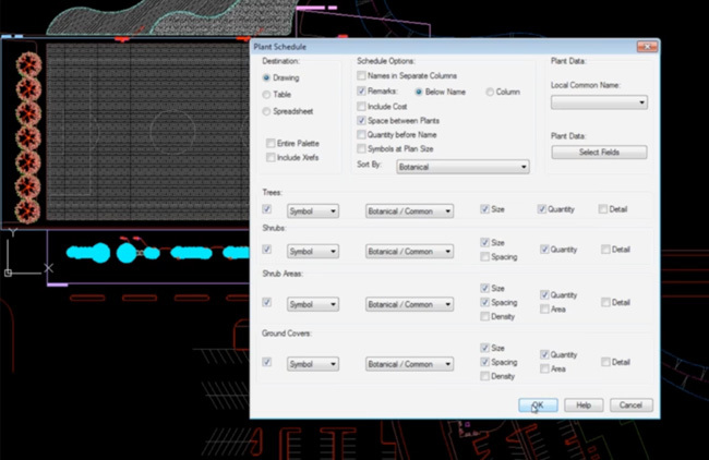
Land F/X’s +20,000 plant database is a constantly growing resource, with new plants created by other users provided to the entire Land F/X community. Each plant that you select from this database can then be assigned a symbol either from Land F/X’s library of over 1,000 blocks, or from your personal collection. Plants can even be assigned to hatches for quick area-based calculations. Plant labelling and scheduling can also be generated quickly and with ease.
Customisable plant scheduling tools | Land F/X
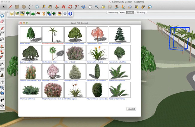
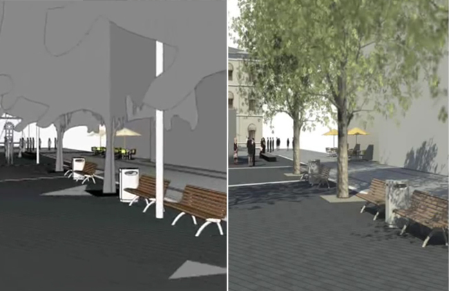
The Land F/X also offers SketchUp Connection, a free and neat SketchUp plugin that allows users to import and export seamlessly between AutoCAD and SketchUp. 2D plant and site furnishing symbols from Land F/X’s CAD library are automatically translated into 3D models within SketchUp.
SketchUp Connection provides two-way interoperability with SketchUp | Land F/X
Jeremiah Farmer, CEO and Developer of Land F/X, was kind enough to offer some of his time to respond to a few of my questions regarding Land F/X and BIM. According to Farmer, Land F/X’s BIM capabilities include:
“Instant and accurate quantities, labeling tools, plan error-checking, 3D visualization, cost estimation tools–basically, all the CAD work that typically takes a huge chunk of time.”
What I found most interesting was Jeremiah’s description of BIM:
“BIM is a ridiculously over-used word, you might as well say “smurfy” or “computerable”. BIM is used to describe everything from quantity take-offs to 3D visualization to coordinating with other disciplines in real-time, to even crossing over into facilities management. So, that being said, “BIM” is just an idea and if anything a file protocol.”
Not dissimilar to my discussion of BIM in article #2 of this series The BIM Revolution, I think Jeremiah’s response to the word as being ‘over-used’ is perhaps the result of its broad definition.
SEE RELATED: Digitising Landscape Architecture: Revit
When asked about Land F/X’s ability to work within Revit, Farmer made clear his preference for the 3D modelling environment provided by SketchUp:
“From our perspective, that of the Landscape Architect, SketchUp is the better 3D collaboration venue, where all disciplines can easily come together. Take resort designers like Disney Imagineering who have roller coaster consultants, or any given firm dealing with skate park or pool consultants–they aren’t going to switch to Revit, but what all of them have with whatever software they are using, is a path to SketchUp.”
Farmer also divulged future plans to incorporate a COBie file translator, aimed at addressing the UK Government’s BIM mandate, so that Land F/X’s UK clients can keep up with the compulsory rollout for BIM within the UK’s public sector construction projects. It’s also something worth keeping an eye on in relation to the BIM revolution, and how it affects the work of landscape architects elsewhere.
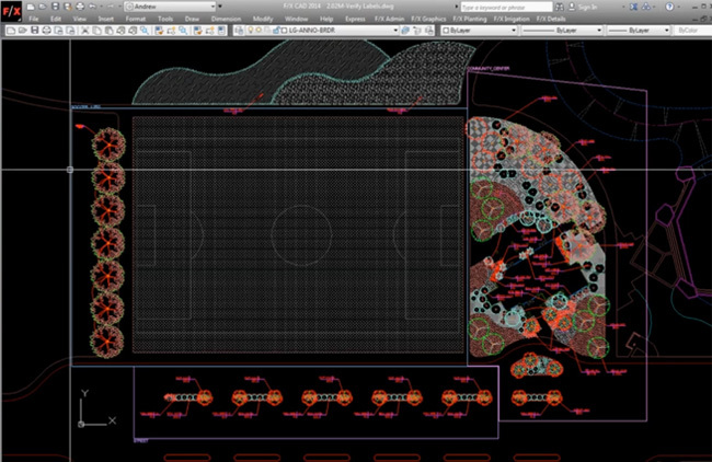
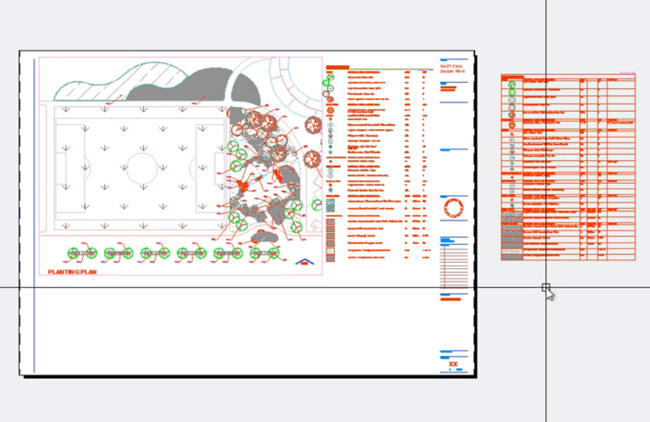
Automated plant symbols and labelling within a familiar CAD environment | Land F/X
If I’ve peaked your interest in the software, educational and trial versions of Land F/X are available via their website, as are webinars on everything from CAD basics to mastering the planting tools. As usual, be sure to let us know how you go!
A big thank you to Jeremiah Farmer for his time! This article is part of the Digitising Landscape Architecture series. Click here to view other articles in the series.
Jason Packenham is a Landscape Architect at Corkery Consulting and design studio tutor in the Bachelor of Landscape Architecture program at the University of New South Wales.
Revit for Landscape Architects
Most landscape architects don’t use Revit, and it’s not surprising to see why. Right from the outset, even Autodesk’s description of Revit demonstrates the software’s inclination towards architects and buildings:
“Autodesk Revit software is specifically built for Building Information Modelling (BIM), helping building professionals to design, build and maintain higher-quality, more energy-efficient buildings.” (Autodesk 2014)
Although Autodesk appears to favor the architecture, engineering and construction (AEC) industry over landscape-specific capabilities, there are a number–my guess is that this is relatively small–of landscape architects that do successfully work with Revit. One of the major benefits of doing so is the ability to more closely collaborate with other professions of the AEC industry who also work with Revit.
In addition to a more streamlined workflow, there are also additional ways that Revit can be applied to the work of a landscape architect. Most of these benefits are related to the modelling of exterior site design elements such as retaining walls, areas of paving, site fixtures such as fences, handrails, seating and so on. Associated with these parametric objects is a database of information that can be used for detailing, quantity take-offs, procurement, future maintenance requirements, etc. Plus, since the workflow of Revit is centred on the creation of a virtual 3D model of your design, amendments made to this design can be carried across multiple drawings (plans, sections, 3D views), which leads to greater work efficiency.
Modelling and rendering exterior site design elements such as areas of paving and site fixtures | Revit Landscape
For instance, Revit’s Toposurface tool allows for the creation of a 3D terrain model. A basic Toposurface is usually created by either placing spot levels yourself or by importing 3D terrain data from another drawing. Terrain information from Google Earth can be incorporated within your Revit model by importing the terrain into SketchUp and exporting this to .dwg.
A Landscape Architect’s Experience with Revit
I recently spoke with Lauren Schmidt, landscape architect, Revit user and BIM blogger, about how her experience with the program.
Jason Packenham (JP) – What type of landscape architecture work are you typically involved in?
Lauren Schmidt (LS) – As a part of an architecture/engineering firm, most of the projects I work on are sites that are focused around a building. Those projects range from K-12 schools, higher education, corporate offices, to urban infill development. We also work on more traditional landscape architecture work, such as parks, trails, and master plans.
JP – Given the hesitance by many landscape architects to make the switch to Revit, what influenced your decision to do so?
LS – Well, it was actually an idea that originated from architecture. They have been working in Revit for about 6 years – all of the other building-oriented disciplines; interiors, mechanical, electrical, and plumbing, work entirely in Revit. Only our civil engineers and landscape architects still work in AutoCAD.
The tipping point happened 2 years ago. Most of our office was working on a large, complex high school project. We found that the landscape was being drawn repeatedly and in too many places; plans in AutoCAD, 3D model in SketchUp, sections drafted in AutoCAD, and yet a Revit model was still created so the other disciplines could visualize and coordinate with the landscape. Consolidating all of that into Revit just made sense.
JP – With Revit being oriented predominantly towards architects, what ‘landscape’ and BIM features does the program offer? And how do you use these features within your projects?
LS – I will be the first to admit that Revit is not perfect for creating landscapes. What is often the most useful are the standard BIM features, like the ability to schedule and tag “smart” objects; planting schedules, plan notes, and cost estimates require almost no effort. But the simplest and best feature is having an accurate 3D model that is also driving your construction documents.
JP – How has adopting Revit influenced how you collaborate with other architecture, engineering and construction industry professionals?
LS – With the landscape in Revit, collaboration with architecture and engineering is on an entirely different level. I have their ‘live’ model linked directly into the landscape model and vice versa – and as these projects move into construction, contractors are asking for these BIM models for cost estimating, clash detection, and construction sequencing. Eventually, BIM will be industry standard, because anything less won’t be worth it.
(Related Article: BIM in Landscape Architecture)
Scheduling in Revit | Lauren Schmidt
Can Revit Boost Interdisciplinary Collaboration?
For a better idea of how Revit can aid collaboration with other AEC industry professionals, I also spoke with Lachlan Stanton, Architect at Drum Rose Architects, based in Sydney, Australia. I asked him about the advantages of collaborating with landscape architects using Revit instead of 2D CAD alternatives.
“I guess one of the biggest factors is the ability to collaborate in 3D. Revit’s ‘Central Model’ allows for multiple people to work on different elements of the model whilst compiling all the information into one central model. This means that a landscape architect could model exterior design elements such as topography and vegetation while the architect sticks to the building. As the project progresses, the Central Model would build into a complete model. This would save the need to have multiple drawings, and to be constantly sending updated plans back and forth.
Revit also has the power to implement sun paths and see what shadows trees and other vegetation cast. It can also be used to show how much light these plants have access to and show how the landscape will change over time. This means the landscape architects modelling can directly influence the work we do as architects, and have a greater impact on project outcomes.”
With this being said, standalone Revit doesn’t offer a landscape architect the same site-design and landscape capabilities that other programs do. However, Eagle Point’s add-on programs Siteworks and LANDCADD can increase the landscape-specific functionality of Revit.
Grading tools in 2D and 3D | Eagle Point
Using Eagle Point’s Products to Increase Functionality
Eagle Point’s products offer landscape architects the ability to shape terrain using grading tools to model pads, parking lots, streets, sidewalks and retaining walls. LANDCADD also enables the locating of trees, shrubs and groundcovers into the model, which are associated with a large database of searchable plants. You are also able to lay out other landscaping features, such as paths, plazas or parking areas and obtain areas or take-off materials.
3D visualisations seem a little scant on landscape details | Eagle Point
Pushback Against Revit in Landscape Architecture — Is it Worth the Investment?
The popular landscape-specific add-on for AutoCAD, Land F/X, does not work with Revit. I recently caught up with Jeremiah Farmer, CEO and Developer of Land F/X to ask why. He explained: “Revit is a non-starter for Landscape Architecture – it is wholly unsuited for site and landscape work. We have heard nothing but horror stories of clients being forced to use it. Revit has a simple and clear path to export the building to SketchUp. So from our perspective, that of the Landscape Architect, SketchUp is the better 3D collaboration venue, where all disciplines can easily come together.”
A part of me gets the feeling that the presence of Revit within a small portion of the landscape architecture profession is probably due to the pressure for landscape architects to collaborate with architects and other professionals already using the program. This then raises an important point for landscape architecture firms where collaboration with other professionals using Revit isn’t a priority.
Revit wasn’t really made for us landscape architects, and despite anecdotal evidence of its success for some, it’s hard to recommend it. Although there are additional add-on programs available for Revit that are oriented towards landscape architects, I think we are still a fair way off Revit offering a comprehensive option for a landscape architecture firm to justify the cash and time investment.
A big thank you to Lauren Schmidt and Lachlan Stanton for their input to this article! This article is part of the Digitising Landscape Architecture series. Click here to view other articles in the series.
Jason Packenham is a Landscape Architect at Corkery Consulting and design studio tutor in the Bachelor of Landscape Architecture program at the University of New South Wales.
Digitising Landscape Architecture: Civil 3D for Landscape Architects
Civil 3D is a design and documentation program that supports BIM workflows. Although it’s not a program specifically tailored for landscape architects, we can still benefit from its powerful and useful features for analysis as well as its tools for design automation and visualisation.
Civil 3D also offers another big advantage for landscape architects requiring close collaboration with engineers. The drawing and information exchange as well as its interoperability with other engineering software makes it a flexible tool for both disciplines.
Surfaces: Civil 3D Building Blocks
Before we go any further, the first and major thing you’ll need to understand about Civil 3D are its basic building blocks called Surfaces. According to the Autodesk explanation, a Surface is:
“a three-dimensional geometric representation of an area of land…made up of triangles or grids…To use a surface in your drawing, you can create an empty surface and then add data to it…Points or contours are usually a primary part of the original surface information.”
So how can a Surface in Civil 3D work for a landscape architect?
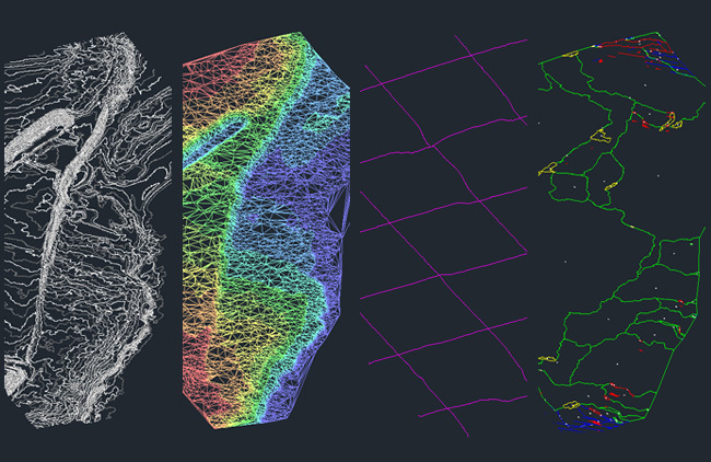
Progression from 3D contour information to a surface in the form of a triangulated irregular network (TIN) – this surface then automates analysis including elevation, cross-sections and watershed | Corkery Consulting
Transform “Dumb” Lines into “Smart” Objects
First, Civil 3D gives us the ability to turn our “dumb” contour lines into a “smart,” interactive model. We can import existing elevation data into Civil 3D to create another surface that we can add to and manipulate in multiple ways. Using the automated features of Civil 3D, analysis of elevation, slope, aspect and hydrology can be performed; numerous cross sections through the site can also be drawn with the click of a mouse, all using the automated features of Civil 3D. When used in conjunction with Autodesk’s Raster Design, geo-referenced aerial imagery can also be placed in our drawing with speed and precision.
(Related Story: Digitising Landscape Architecture – From CAD to BIM and Everything in Between)
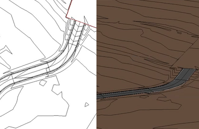
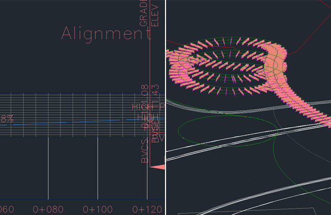
An Alignment is projected up to the Surface to create a Profile.
An Assembly is then applied to this Profile to create a Corridor.
Ease of Application and Analysis
Some tools that landscape architects may find particularly useful in Civil 3D are Alignments, Profiles, Assemblies and Corridors. Alignments, for instance, can turn lines and curves into a smart object representing road centerlines and pipe networks. The Assembly, on the other hand, could incorporate the detailed design of a footpath or retaining wall. These Assemblies can then be applied to Profiles throughout your model, with any future amendments to the detailed design of your path or wall made to the Assembly, and updates automatically carried through to your Corridor, updating your plans, sections and 3D views simultaneously.
As an additional plus, all the analysis performed on the existing Surface can also be performed on proposed Surfaces. The proposed design interventions can be assessed in terms of elevation, slope, aspect and hydrology, and cut and fill calculations can also be made to balance earthworks requirements. To go one step further, design levels of paths, plazas, landforms, etc. can then be adjusted in the final design stages to assist with balancing cut and fill requirements and reducing associated costs. These small changes can be made easier by working in section views of each Profile.
Working in section and 3d view simultaneously | Corkery Consulting
Software Interoperability and Flexibility
Civil 3D’s surfaces can even be exported to SketchUp by exporting its triangles to another drawing file (using the WBLOCK command – Google it!). Surfaces can also be exported to Autodesk InfraWorks via Civil 3D’s Export IMX function (more on InfraWorks in its own article later in the series). Other modelled components can also be WBLOCK exported to either SketchUp or InfraWorks.
The landscape-specific add-on Land F/X also works within Civil 3D (unlike Revit). Combining its planting, irrigation and SketchUp integration tools with Civil 3D’s powerful landscape modelling functions could potentially provide the landscape architect with a commanding inventory of automated tools.
Furthermore, Civil 3D allows for exporting to Civil View (a built-in plugin that runs within 3ds Max) to help streamline the process of moving Civil 3D data to 3ds Max for visualisation. This potentially allows landscape architects to be involved in the environmental and visual impact assessment for infrastructure projects, as well as being a part of the community consultation process for such projects.
All-in-all, Civil 3D provides some landscape-specific functions that are absent in AutoCAD and Revit. The program should be of particular interest to those who usually work on large-scale landscape planning projects or in collaboration with engineers on infrastructure projects. Although Civil 3D doesn’t tick every box and does have its shortcomings, it does provides a number of useful analysis and modelling functions and is worth looking into if you or your office is interested in expanding your modelling capabilities.
(Related Story: Digitising Landscape Architecture: The BIM Revolution)
This article is part of the Digitising Landscape Architecture series. Click here to view other articles in the series.
Jason Packenham is a Landscape Architect at Corkery Consulting and design studio tutor in the Bachelor of Landscape Architecture program at the University of New South Wales.
Digitising Landscape Architecture: The BIM Revolution
With the increased prevalence of BIM in the architecture, engineering and construction (AEC) industry, there has been ongoing debate within the profession of landscape architecture regarding the need to adopt BIM workflows.
Debate on the suitability of BIM-enabling programs aside, it’s impossible to ignore the growing push towards adopting BIM technologies. The UK Government, for instance, has even instated the compulsory adoption of BIM technologies and processes to increase collaboration at all stages of the project. (BIM Open Project, 2014)
What is BIM?
Depending on who you ask, the definition of BIM tends to differ. For example, in ASLA’s LATIS 2008 paper Integrating BIM Technology into Landscape Architecture (Sipes, 2008), BIM is discussed as a form of 3D modelling with intelligent data attached to the modelled ‘objects’; much of its discussion revolves around the process of modelling. On the other hand, the Landscape Institute has taken the position that BIM is more about the process of sharing information (Slavid, 2014).
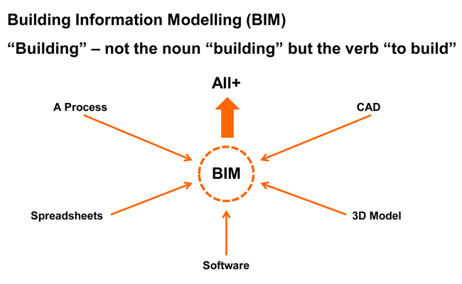
The Landscape Institute also says the term ‘Building Information Modelling’ js complicated by the fact that the word ‘building’ is a verb, and so the acronym could be interpreted as ‘To Build an Information Model’, with the model potentially containing much more information than that related to a building. This information includes all data relating to design, costing, build-ability, clash detection, scheduling and procurement, sustainability impact, life cycle and facilities management factors (What is BIM?, 2014).
The Landscape Institute’s definition of BIM | Landscape Institute
For the landscape architect, BIM can help transform a tree symbol in 2D CAD from a bundle of polylines and hatches into an intelligent tree ‘object.’ The smart tree object is now documented in a database for easy scheduling, procurement, costing, maintenance requirements and so on. Not only do we know it’s a tree, the tree “knows” it’s a tree and can offer up its height, width, whole-of-life performance information, sustainability impact, etc. without us inputing or knowing that information beforehand.
BIM intelligence provides data relating to the modelled objects | Land F/X
Most importantly though, BIM offers an integrated process built on coordinating and streamlining information about a project from design through construction and into operations and maintenance. Depending on your project needs, there are now several programs available that can help with collating these databases of information in association with BIM ‘objects’.
(Related Story: BIM in Landscape Architecture)
As a result, the integrated information in BIM can increase efficiency and even minimize user error in workflows. A parametric object can now store libraries of information and create easy access to up-to-date detailing, quantity take-offs, procurement, future maintenance requirements, etc. Once amendments are made across multiple drawings (plans, sections, models), the quantity and types of certain objects will also be automatically updated and eliminate the need to manually count and record the changes. When modeling the ‘smart’ tree, we are building information into the project model with the ultimate aim of creating coordinated, reliable information for all stages of a project’s life-cycle and facilitating true collaboration within the project team.
What does BIM mean for landscape architects?
First and foremost, don’t rush into committing to a particular software package believing it will be the all-in-one answer you’ve been waiting for. Over the years, popular CAD programs have been tailored much more to the remainder of the AEC industry than to landscape architects. The current state of the BIM revolution would suggest this trend is likely to continue, at least with mainstream developers such as Autodesk and Bentley.
BIM Modelling | The Beck Group via Eagle Point
That doesn’t mean landscape architects won’t get a say, however. My advice is to stay tuned to those already engaged in the BIM revolution. The Landscape Institute is proactively involved in ensuring that the requirements of landscape architecture are considered as the UK’s AEC industry moves towards compulsory BIM project deliverables. They have a wealth of information available on their website. For anyone with the time, I would also recommend reviewing ASLA’s LATIS 2008 paper Integrating BIM Technology into Landscape Architecture.
Furthermore, stay tuned to the ‘big players’ in the BIM game – Autodesk, Nemetschek, Land F/X, Eagle Point, amongst some others. As already mentioned in the introductory article to this series, what landscape architects ‘do’ can vary so significantly that finding one particular program to suit all of our needs is highly unlikely, so engage with all your options. The BIM world is a business after all, and if landscape architects express their interest and need, business-savvy developers will be sure to fill the BIM gap.
To learn more about BIM in landscape architecture, stay tuned to the Digitising Landscape Architecture series, as we explore some of the more popular BIM-enabling programs used by landscape architects.
References
BIM Open Project. (2014). Retrieved March 31st, 2014, from Landscape Institute: http://www.landscapeinstitute.org/knowledge/BIMOpenProject.php
Sipes, J. L. (2008). LATIS – Integrating BIM Technology into Landscape Architecture. Washington DC: American Society of Landscape Architects.
Slavid, R. (2014). BIM for Landscape. Landscape.
What is BIM? (2014). Retrieved March 31st, 2014, from Landscape Institute: http://www.landscapeinstitute.org/knowledge/WhatisBIM.php
This article is part of the Digitising Landscape Architecture series. Click here to view other articles in the series.
Jason Packenham is a Landscape Architect at Corkery Consulting and design studio tutor in the Bachelor of Landscape Architecture program at the University of New South Wales.


