Civil 3D is a design and documentation program that supports BIM workflows. Although it’s not a program specifically tailored for landscape architects, we can still benefit from its powerful and useful features for analysis as well as its tools for design automation and visualisation.
Civil 3D also offers another big advantage for landscape architects requiring close collaboration with engineers. The drawing and information exchange as well as its interoperability with other engineering software makes it a flexible tool for both disciplines.
Surfaces: Civil 3D Building Blocks
Before we go any further, the first and major thing you’ll need to understand about Civil 3D are its basic building blocks called Surfaces. According to the Autodesk explanation, a Surface is:
“a three-dimensional geometric representation of an area of land…made up of triangles or grids…To use a surface in your drawing, you can create an empty surface and then add data to it…Points or contours are usually a primary part of the original surface information.”
So how can a Surface in Civil 3D work for a landscape architect?
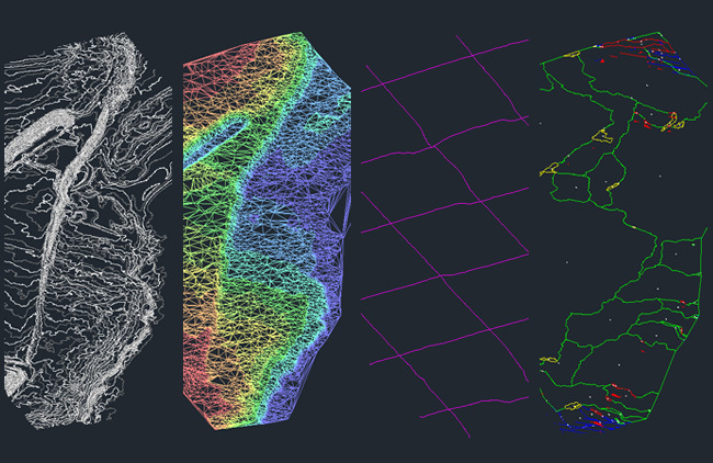
Progression from 3D contour information to a surface in the form of a triangulated irregular network (TIN) – this surface then automates analysis including elevation, cross-sections and watershed | Corkery Consulting
Transform “Dumb” Lines into “Smart” Objects
First, Civil 3D gives us the ability to turn our “dumb” contour lines into a “smart,” interactive model. We can import existing elevation data into Civil 3D to create another surface that we can add to and manipulate in multiple ways. Using the automated features of Civil 3D, analysis of elevation, slope, aspect and hydrology can be performed; numerous cross sections through the site can also be drawn with the click of a mouse, all using the automated features of Civil 3D. When used in conjunction with Autodesk’s Raster Design, geo-referenced aerial imagery can also be placed in our drawing with speed and precision.
(Related Story: Digitising Landscape Architecture – From CAD to BIM and Everything in Between)
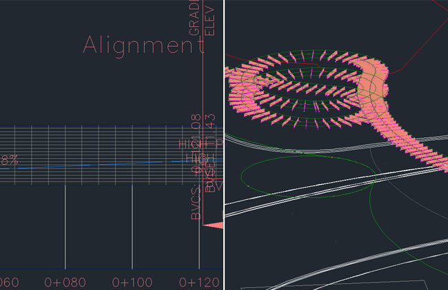
An Alignment is projected up to the Surface to create a Profile.
An Assembly is then applied to this Profile to create a Corridor.
Ease of Application and Analysis
Some tools that landscape architects may find particularly useful in Civil 3D are Alignments, Profiles, Assemblies and Corridors. Alignments, for instance, can turn lines and curves into a smart object representing road centerlines and pipe networks. The Assembly, on the other hand, could incorporate the detailed design of a footpath or retaining wall. These Assemblies can then be applied to Profiles throughout your model, with any future amendments to the detailed design of your path or wall made to the Assembly, and updates automatically carried through to your Corridor, updating your plans, sections and 3D views simultaneously.
As an additional plus, all the analysis performed on the existing Surface can also be performed on proposed Surfaces. The proposed design interventions can be assessed in terms of elevation, slope, aspect and hydrology, and cut and fill calculations can also be made to balance earthworks requirements. To go one step further, design levels of paths, plazas, landforms, etc. can then be adjusted in the final design stages to assist with balancing cut and fill requirements and reducing associated costs. These small changes can be made easier by working in section views of each Profile.
Working in section and 3d view simultaneously | Corkery Consulting
Software Interoperability and Flexibility
Civil 3D’s surfaces can even be exported to SketchUp by exporting its triangles to another drawing file (using the WBLOCK command – Google it!). Surfaces can also be exported to Autodesk InfraWorks via Civil 3D’s Export IMX function (more on InfraWorks in its own article later in the series). Other modelled components can also be WBLOCK exported to either SketchUp or InfraWorks.
The landscape-specific add-on Land F/X also works within Civil 3D (unlike Revit). Combining its planting, irrigation and SketchUp integration tools with Civil 3D’s powerful landscape modelling functions could potentially provide the landscape architect with a commanding inventory of automated tools.
Furthermore, Civil 3D allows for exporting to Civil View (a built-in plugin that runs within 3ds Max) to help streamline the process of moving Civil 3D data to 3ds Max for visualisation. This potentially allows landscape architects to be involved in the environmental and visual impact assessment for infrastructure projects, as well as being a part of the community consultation process for such projects.
All-in-all, Civil 3D provides some landscape-specific functions that are absent in AutoCAD and Revit. The program should be of particular interest to those who usually work on large-scale landscape planning projects or in collaboration with engineers on infrastructure projects. Although Civil 3D doesn’t tick every box and does have its shortcomings, it does provides a number of useful analysis and modelling functions and is worth looking into if you or your office is interested in expanding your modelling capabilities.
(Related Story: Digitising Landscape Architecture: The BIM Revolution)
This article is part of the Digitising Landscape Architecture series. Click here to view other articles in the series.
Jason Packenham is a Landscape Architect at Corkery Consulting and design studio tutor in the Bachelor of Landscape Architecture program at the University of New South Wales.
Published in Blog






landscapeplanner
I would also add parceling, creation of surfaces from DEMs, and MAPWSPACE.
Jason Packenham
Thanks for the additional points!
For those who are interested, Civil 3D also allows the creation of ‘parcels’, which are typically used to represent real estate lots in a subdivision. In essence, they are ‘smart polygons’ with styles, settings and properties that relate specifically to real estate lots and can improve efficiency when working with these elements.
Regarding Surfaces, there are other methods of creating surfaces beyond those mentioned in the article (such as surfaces from DEMs as mentioned below) but for the sake of the articles word count I had chosen to focus only on contours as this is what most people would understand. For anyone wanting to know more about Surfaces, check out Autodesk’s Civil 3D User Guide:
http://docs.autodesk.com/CIV3D/2013/ENU/index.html?url=filesCUG/GUID-A3FDD6BB-F7D8-4E26-BBFF-3DEE7DF4FF91.htm,topicNumber=CUGd30e119727
Jamie Metcalfe
Great series of articles. I am required to learn Civils 3D for work, is anyone aware of any good courses either in the Uk or online? Cheers 🙂
Jason Packenham
Thanks Jamie,
I’d start with Autodesk University’s on-demand classes (you’ll have to create an Autodesk account, which is easy enough):
http://au.autodesk.com/au-online/overview
Or try the Civil 3D User Guide getting started tutorials – find the tutorials link on this page:
http://www.autodesk.com.au/products/autodesk-autocad-civil-3d/overview
Good luck!