Your guide to all the top computer software for landscape architects. There is a plethora of Computer Aided Software or CAD options on the market. All have something to offer for everyone from the budget focused landscape architecture student to the professional wanting a fully comprehensive package. Here we take you through a range of software options to suite all budgets and needs.
Software for Landscape Architects
- Sketchup
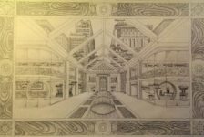
Sketchup is a FREE 3D drafting package with probably the world’s most intuitive interface. Much maligned for its simplicity, over the years Sketchup has gotten a bit of a bad rap for being ‘blocky’ or ‘too geometric’. However I’ve always found it to be as good as the designer using it. WATCH: Instant Topography with the Toggle Terrain Tool – The SketchUp Tutorials for Landscape Architects As well as being able to work in a 1:1 scale in 3D, there is a range of tools for lighting and set camera angles. The Sketchup 3D Warehouse allows you to download models of trees and plants straight into your own model.
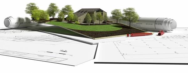
3D Visualisation from www.teresapottergardens.co.uk
- AutoCAD
AutoCAD, by Autodesk, comes in a comprehensive range of packages to suit most needs, and since 2012 has also supported MAC OS. Probably the most useful package for landscape architects is AutoCAD MAP 3D. This package fully supports Geographic Information System (GIS) and LiDAR (Light Detecting and Ranging) data sets, and allows you to create models over Geo-referenced rasterized images of maps.
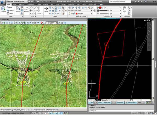
Pictometry for Autocad map 3D. Credit: @gletham GIS, Social, Mobile Tech Images; CC2.0
- LandFX
LandFX is a very comprehensive landscape architecture CAD ‘plug-in’ that generates very good hard and soft landscape plans and construction/planting details. With a database of over 20,000 plants its unlikely any user is going to run out of plants to specify. As LandFX is a ‘plug-in’ it requires full AutoCAD to run – NOT AutoCAD LT (as aposed to Keyscape which comes with its own CAD driver, and so there is no need to buy an additional CAD program). This can make it a more expensive solution and therefore perhaps not suitable for the budget minded landscape architect or landscape student. WATCH: LandFX to Sketchup Bottom line: LandFX is very powerful and comprehensive product for the professional landscape architect. However, it’s requirement for full AutoCAD might make it too expensive for some. LandFX can be downloaded here.
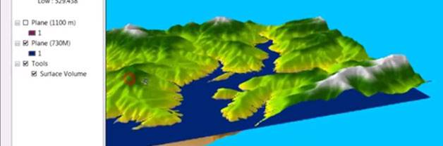
- ArcGIS
ArcGIS, by Esri, is a Geographical Information System (GIS) for producing intelligent mapping and Geo-spatial graphics. The two main benefits of GIS are the breadth and depth of information that can be accessed, stored, and represented for any given location; and the ease at which that information can be shared. ArcGIS offers a range of desktop based platforms, from a simple viewer (known as Desktop Basic) that allows the user to view GIS files, through to the full package ‘Desktop Advanced’. There is even an online subscription based option that ensures you have access to GIS data no matter where you are or what device you are using. ArcGIS will suit any student or professional working on planning larger areas/neighborhoods, and those working in multidisciplinary teams. WATCH: ArcGIS 10 – Calculate Area and Volume of a Reservoir Bottom line: Arc GIS is a professional tool with very powerful capabilities for landscape architects, that comes in a range of solutions to suit most budgets. The full range of Esri’s products can be explored here.
- Keyscape Design Studio
Keyscape Design Studio, by Keysystems, is a dedicated landscape package running on an AutoCAD platform. It is a very flexible package that allows you to add to the range of 2D and 3G graphics. Planting plans are easily produced using the preloaded database of over 7500 plants. Hard landscape plans can also easily be produced using a range of editable hardscape patterns. As Keyscape runs on an AutoCAD platform it is fully integrated with the industry standard file format, making sharing of files easy. There is also a lite version for the more budget minded user. From personal experience I have always found their customer support and training to be first class. Bottom line: A great piece of landscape software that allows the user a great deal of flexibility. Download a trial version of Keyscape Design Studio here.
- ArchiCAD
ArchiCAD by Graphisoft is a CAD drawing and rendering program comparable with Autodesk’s main AutoCAD program. In price there isn’t much to chose between the two, so much of the choice comes down to personal preference and differences in features. Autodesk have a propensity to create many different programs aimed at specific markets, where as the flagship ArchiCAD program is more of an all singing all dancing option, that includes BIM and sophisticated rendering. Related Articles:
- Top 10 Hints & Tips For SketchUp
- 10 AutoCAD Hacks for Beginners!
- 3D Modeling Software for Landscape Architects

Visualization of an office made in ArchiCAD 14. Credit: Menziesa; GNU Free Documentation License
- Vectorworks Landmark
There is an age old debate between those who prefer Vectorworks (VW) and those who prefer AutoCAD. Essentially the two programs approach the same solutions from different angles. AutoCAD is said to be more programmatic and efficient, while VW is said to be more intuitive to those of an artistic nature. I originally trained in VW, but moved over to AutoCAD as it is the industry standard in the UK. I enjoyed VW, and did indeed find it more intuitive and easier to create quick 3D models, but working in multidisciplinary teams requires the ability to be able to share data and generate tender and construction drawings from shared files, and so therefore I had to learn to use AutoCAD. WATCH: Welcome to Vectorworks Landmark Bottom line: VW Landmark does everything a landscape architect requires from CAD software in an intuitive and stylish way, but is not industry standard in some countries. Find out more and here.
- Rhino
For rendering of 3D models Rhino 5 offers a very capable package that will feel like second nature to any experienced CAD user. Even if you are a novice, Rhino explains what all their tools do in a straight-forward way so that you can be creating 3D CAD models in no time. There is also a range of ‘plug-ins’ available like Grasshopper and Flamingo that allow you to create photo-realistic models that are easily editable. WATCH: How to get a Free 3D Tree Library for Rhino with VRay Support Bottom line: Rhino is a powerful industry standard rendering program that offers the landscape architect everything they need to create photo-realistic rendered CAD models. FREE trials of Rhino can be downloaded here.
- Blender
Aimed at the animation and gaming market, Blender offers the landscape architect a powerful (and above all FREE) photo-realistic rendering package. Being open source software, Blender has a wide range of ever changing capabilities that allow the user to create models, and then animate them with surprisingly sophisticated tools. Features that will appeal to the landscape architect include the speed at which simple rendered models can be created, and the simplicity of walk through/fly-by animation. WATCH: Blender Tutorial: How to make a grass field? Bottom line: Blender is a great open source project that offers the budget minded landscape professional or student free photo-realistic 3D model rendering. Find out more about the Blender project here. With a such a range of CAD software available to the landscape architect it can sometimes seem daunting choosing a program. While some choices (such as AutoCAD/Vectorworks) might come down to personal preference, there are some great FREE CAD options like Sketchup and Blender that are worth investigating. What is your personal CAD preference? Recommended Reading:
- SketchUp 2014 For Dummies by Aidan Chopra
- The Complete Guide to Blender Graphics, Second Edition: Computer Modeling and Animation by John M. Blain
Article by Ashley Penn Return to Homepage Featured image: Printscreen from Youtube; source.
Published in Blog