Landscape architects must seize leadership roles in Geodesign — the fusing of design processes with geospatial technologies — or risk ceding it to other professions. That was the sentiment expressed by ESRI President Jack Dangermond’s opening keynote speech at the Boston ASLA annual meeting. Dangermond envisions a 50-100 year plan for the planet, which will succeed only if we merge the “best design talent and science and technology.” He feels the way forward is the “landscape architect’s methodology.”
As landscape architects, we are poised to lead and implement innovative solutions to pressing design and planning challenges worldwide. Using Geodesign to integrate geographic information into many forms of spatial design and decision-making will help our profession grow and gain influence. To this end, Penn State has just launched a new online graduate Geodesign certificate program that can be completed both online and part-time. But first, I’d like to share some background.

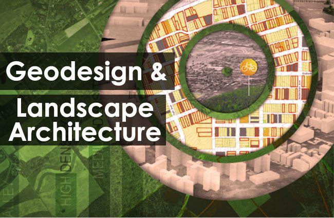
Geodesign is both complex and innovative. The above graphic, designed for Penn State’s new programs, hints at some key characteristics of Geodesign:
- Geodesign is a process that targets appropriate solutions (bull’s eye)
- Geodesign evaluates/ measures design ideas (bar chart)
- Geodesign works towards sustainable solutions (green color; biking icon)
- Geodesign encompasses design for places from regions to cities (visible in the rings)
Don’t think for a minute, though, that Geodesign is merely landscape architecture juiced up. Heavily influenced by landscape architect Ian McHarg’s “Design with Nature” approach to the field, Geodesign layers spatial thinking, design, valuation, rapid iteration with real-time feedback, GIS/ data processing, and stakeholder participation – all rooted in a values-based approach.

Design and planning processes often start with data gathering, however, whether GIS is used or not, if it this initial phase is unfocused, it can result in a data overload. A key hallmark of the Geodesign process, on the other hand, as espoused by Geodesign “guru” Dr. Carl Steinitz, begins with people – engaging stakeholders who will be impacted by proposed changes – to truly understand the needs and issues. No major land use or planning change initiative will succeed if decision makers are not involved in the process that identifies change options.
Gaining a deep understanding of how best to engage the people of the place is just one of the unique features of Penn State’s Geodesign programs. The coursework and student-faculty dialogue bring Geodesign’s complexity down to earth through case studies and student exploration of their own Geodesign challenges.

An example: recent Geodesign studios at Penn State showcase how an extremely complex, multifaceted challenge, in this case the impact and opportunities of shale gas exploration in N.E. Pennsylvania, can promote innovative, far-reaching change.
Penn State’s new Geodesign programs are the result of collaboration between our top-ranked landscape architecture and geography departments, guided by an internationally recognized advisory board. These programs — a graduate certificate and forthcoming Master’s degree (final approvals pending) — enable working professionals to advance their skills and gain this critical expertise, all while working online from your current location. Take advantage of this exciting opportunity for landscape architects to become leaders in Geodesign!
For more information about Penn State’s online Geodesign graduate programs, visit: PSU Geodesign and Geodesign Certificate Overview
(All images from Penn State University, Department of Landscape Architecture)
Published in Blog