


Author: Helen Buckle

Beauty on a Budget: Landscape Architects EMF Transform Urban Wasteland into Barcelona Pocket Park
What kind of public space could you create with less than $4 per square foot ($40 per square meter)? In the wake of the economic crisis, Spanish landscape architects EMF were given a total budget of 40,000 Euros ($54,000) to temporarily transform 1,330 square meters (~14,300 square feet) of derelict urban space in Barcelona.
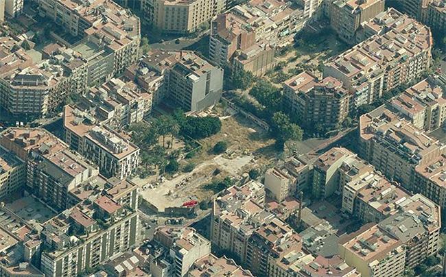
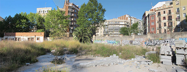
Aerial photo and before shot via Ajuntament de Barcelona
Located in the Eixample district of Barcelona, the neglected pocket of space had been identified as an area for future development. Due to the economic crisis, however, development of the site was temporarily suspended. The area became an unsightly storage facility for waste materials from adjacent construction sites. The city council therefore sought a temporary solution for this ephemeral wasteland.

Twenty percent of the budget was immediately spent on making the site safe for public use. With both limited time and money remaining, EMF decided to utilise the existing waste materials as an integral part of their design proposal. They created a catalogue of all the materials on site, making note of types and quantities. The catalogue was then used to reconfigure all the materials into a new public space.
RELATED STORY: Tanner Springs Park | Portland, OR

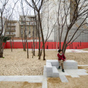
Concrete blocks and slabs were recycled to form pathways and seating areas. Existing trees were retained and surrounded with woodchips, creating a change of texture underfoot. Scented shrubs were planted along the main access route.

Red and white paint was chosen as a cost-effective yet striking way to enliven the space. The use of bold colours and abstract shapes transform this former wasteland into contemporary work of art reminiscent of a Mondrian painting. Stripes of blackboard paint invite passers-by to engage with the environment, scribbling their own marks onto this giant canvas.

The project forms part of a much larger urban regeneration scheme for the city of Barcelona. The city council has identified fifteen neglected urban spaces to be rejuvenated with a total budget of 900,000 Euros ($1,220,000). Entitled ‘Microurbanització’, the regeneration scheme aims to convert abandoned lots across the city into valuable pocket parks for local residents. All the projects will be completed during 2014.
Photography by Sergi Romero unless otherwise stated.

Are smartphones destroying the ‘public’ in our public realm?
Take a look around you in any urban area – on any street, bus or train, in any mall, park or cafe – we’re all at it; tapping and sliding and thumb-flicking. The smartphone is changing the way we interact with the world, changing the way we communicate with one another and changing the way we behave in public places.
But what does this mean for the dynamic of our built environments? A recent event hosted by the Urban Design Group in London aimed to explore this question. Based on the premise that ‘smart phones will have as much impact on towns and cities as the motor car’, the event examined the possibilities and limitations associated with an increasingly technologically-driven society.
According to Ian Ralph of Alan Baxter Associates, worldwide sales of smartphones overtook those of feature phones earlier this year, with the smartphone now having 77% penetration within the UK. There are now 650,000 applications available for download. Just four years ago there were only 800.
The convenience of the smartphone is its draw-factor. The complexity of its technology and the plethora of applications available mean that, for many of us, our smartphone has replaced a number of other devices, assimilating multiple technologies into one. We no longer require a separate alarm clock, sat-nav, camera, music player, dictaphone, pedometer, calorie-counter. We don’t need to wait until we’re at a computer to check our emails, skype a friend, update facebook or check our twitter feed.
But with everyone now glued to their handsets, engrossed in their own private worlds, how much are we interacting with the real, tangible world around us? What’s happening to the ‘public’ in our public realm?
Public spaces have always formed a vital part of our towns and cities. They’re the places where we spontaneously interact with people who are different from us and they play a fundamental role in fostering a sense of community. Not so long ago, if you were lost or wanted to know where you could find a bite to eat, you’d ask a stranger in the street. Now, we simply download an app.
Research has already shown that smartphone users are – unsurprisingly – less engaged with their surroundings. They remember less about both the people and the spaces they encounter. According to Tali Hatuka, who heads the Laboratory for Contemporary Urban Design at Tel Aviv University “the ubiquitous smart phone may even degrade the way we recognise, memorise and move through cities.”
As designers of the public realm, what can we do about this rapidly emerging urban problem? We can’t halt technology or turn back the clock. It seems to me that the solution could well lie in the source of the problem; in technology itself.
My last blog post – Big Data in the Big Smoke – revealed how Transport for London are utilising smartphone apps and big data sharing to improve the experience and efficiency of the city.
My next blog piece will examine some of the other ways in which designers and app developers are attempting to harness technology in order to improve built form and enrich – rather than detract from – public life.
Top image courtesy of Anna Anastasiou.

Big Data in the Big Smoke
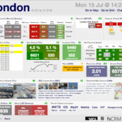
This time-lapse video by Jay Gordon visualizes all 16 million transactions made by the 3.1 million Oyster card users across the city of London in one 24 hour period. The brightness of each pixel represents the number of people in one of three categories. The blue pixels indicate the presence of cardholders either before their first transaction of the day or after their last (assumed to be at home). The green pixels represent passengers in transit, using either bus, rail or tube. The red pixels indicate travelers between transit journeys, whether transferring, traveling outside the transit system or engaging in activities such as working or shopping.
The video was shown by Gareth Sumner of Transport for London (TfL) as part of a recent event hosted by the Urban Design Group (UDG) in London. The event, entitled ‘Smart Phones and Urban Life’, was based on the premise that “the smart phone will have as much impact on towns and cities as the motor car.” WIth speakers from an array of backgrounds, the event aimed to explore how new and rapidly evolving technologies can be employed in urban life and design.
Fellow Land8 writer Jeff Gonot has already been blogging about the emerging phenomenon of Big Data in his three part series ‘Big Data to Big Design’ (read Part One and Part Two here). At the UDG event, Gareth Sumner explained how TfL are using analysis of big data to better understand the daily flow of London and ultimately to improve the experience of every traveler within the city.
Big data in the city of London exists in a multitude of entities. From GPS mobile phone signals to Oyster card journey information to Barclays cycle hire statistics and climate sensors, the data is out there and most importantly; it’s free. Websites such as City Dashboard make data such as this available for anyone to see. A recent report commissioned by the UK government highlighted the need for public sector data to be open and available to everyone. Entitled ‘The Shakespeare Review’ the document stresses the power and potential in being able to combine, analyse, personalise and tailor data.
By sharing and assimilating these vast amounts of intangible data into graphical representations – like the video above – the invisible overlay of digital information that exists in any urban setting evolves into a tangible, understandable entity. Patterns of usage emerge and the ebb and flow of the city becomes more apparent. Understanding these flows and how they relate to urban form allows for the design of more responsive, user-friendly cities.
As well as assisting in the understanding of urban systems on a large scale, real-time data can be communicated to the individual using apps, allowing travelers to make informed decisions about their journeys. This real-time data would be of particular value during big events, such as the Olympics, when large crowds of people could be directed and dissipated around the city with minimum disruption.
But an improved experience of the city is not the only benefit to big data sharing and analysis. In a Deloitte study that was commissioned in parallel to The Shakespeare Review, it was estimated that UK-wide data sharing would generate £1.8 billion (in 2011/12) and that TfL’s efforts in sharing their real-time travel data with customers and app developers has resulted in a time-saving value of £58 million per year for the city of London. The culminated effect of those few precious moments saved by checking the app on your phone for the next available bus equates to considerable financial value. Time is money after all.
The possibilities of big data and the extent to which it could affect the design of the built environment may not yet be fully understood. But one thing is for sure; data gives us increased knowledge. More knowledge allows greater understanding of our environments and the people using them – it allows us to design more extensively and with greater depth. Data is instant and real-time meaning we can test scenarios, measure responses and evolve designs accordingly. The data is out there and we’ve only just begun to scratch the surface.
In my next blog piece I’ll be reflecting on what some of the other speakers at the Smart Phones and Urban Life talk had to say. Could the smart phone really be as influential on towns and cities as the motor car?

Rabalder Park, Denmark
When is a playground not just a playground? When it can hold up to 23,000 cubic meters of rainwater! Designed by Danish landscape architects Nordarch, Rabalder Park fulfills a dual purpose as both a playground and a rainwater harvesting system. More after the jump.


The park is located on the site of a former concrete factory in the Musicon area of Roskilde in Denmark. It combines all the usual amenities of a park – fitness equipment, bike and jogging paths, parkour equipment, trampolines, a performance stage, areas for hanging out and barbecuing – with a water canal and a huge concrete skate bowl that doubles as a floodwater retention pool.

The entire development is fully integrated into the surrounding natural water system, allowing the park to alleviate flooding of nearby areas by diverting and holding the rainwater that would otherwise be pouring through roads and into people’s homes.

The park forms part of a much larger regeneration scheme for this former industrial area of Roskilde. Musicon is intended to become a creative, vibrant and experimental part of the city, providing housing, office space, educational facilities, an indoor skatepark, studios for artists, a folk school and a museum of rock music.

Rabalder Park was recently nominated as a finalist in this year’s Index: Awards. The park also won the Danish Town Planning Prize in 2012.

How else can PLAY be integrated within your city? The PLAYscapes design competition – hosted by Building Trust International – aims to explore such questions and others. Read more about the competition and how you can enter, here.
Tell us what you think! Leave a comment below…
All images courtesy of Nordarch.
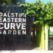

Getting lost in London: The Eastern Curve Garden
Every day for the last six months I’ve hurried past a tall facade of blackened-timber on my way to work. I’d noticed a small, brightly coloured opening in the black hoarding, partially hidden by clambering plants but until last week I’d never ventured through it. What awaited me on the other side was an unexpected pocket of tranquility.

Located in the London borough of Hackney, adjacent to one of the busiest transport hubs in east London, the Eastern Curve Garden sits on the bend of of an old railway line, which once linked Dalston Junction to the North London Line. The railway line closed in 1944 and the tracks were removed in 1965 leaving a sliver of derelict land. The space was boarded up, abandoned and left to become an overgrown urban junkspace.

Above image: The Dalston Mill, photographed by Eliot Wyman
Forty-four years later, the Design for London initiative ‘Making space in Dalston’ identified this forgotten strip of land as one of several opportunities to create desperately needed public green space within the heart of Dalston.

Image above: The Dalston Mill, courtesy of EXYZT
Local landscape architects J&L Gibbons collaborated with muf architecture/art to explore the possibilities for the site. Using a ‘grass roots’ approach, their aim was to develop a vision that would embrace local communities, invite public participation and nurture the existing qualities of the area.


As part of the design process, experimental architectural collective EXYZT was commissioned to construct a temporary installation on the site that would act as a means of exploring and evaluating public responses to new and different uses for the space. The installation, entitled The Dalston Mill, consisted of a five-storey functioning windmill constructed from scaffolding, which was used to produce flour for a local bakery.

Alongside the mill, a 20 meter-long wheat field was installed by environmental artist Agnes Denes as a reinterpretation of her 1982 New York installation ‘Wheatfield’. Over the coming weeks, a programme of events presented by artists and local organisations filled the space and 12,000 people ventured through the old wooden hoarding and into this previously neglected wasteland.

The use of a temporary installation to provide means for a real-time consultation process proved to be a huge success. The initiative demonstrated to local people that change can be a positive experience, increasing social cohesion and altering perceptions of place.

The resulting concept for the space was an ‘eco-garden’ that would retain some of the wild aesthetic of the abandoned site and provide opportunities for community involvement and management.
EXYZT returned in 2010 to design and build a barn-like pavilion on the site that would allow year-round community-run activities. A design and construction apprenticeship scheme was set up for members of the local community college and youth group to assist in the construction of the timber pavilion.

J&L Gibbons responded to the site with a ‘light touch’ approach, maintaining existing vegetation where possible and introducing native species that would thrive on the old railway land.
Clusters of Birch and Alder trees were planted in the Spring of 2010. These pioneer species are often the first to colonise derelict land in British urban environments and, three years on, are already beginning to create a woodland-feel in the garden. Giant bean bags and filled hessian sacks are strewn beneath the trees, providing places for visitors to laze on sunny days.

Reclaimed materials have been used wherever possible, including a boardwalk constructed from railway sleepers and old whiskey barrels that collect rainwater from the roof of the pavilion. Garden chairs have also been made using pallets reclaimed from the nearby Ridley Road market.

Members of the local community were involved at every stage of the design and build process. The pallet chairs are the result of on-site workshops, during which adults and children were shown how to construct the chairs from a template based on a design by Italian furniture designer Enzo Mari.

Above: photograph by Helen Buckle
Bird-boxes, butterfly nests and bird feeders were made and decorated by local school children and a clay oven for making bread and pizza was also built by residents of the borough. On the opening day, local street artist Stik was commissioned to paint a mural on one of the walls entitled ‘putting down roots’.

Above: photograph by Susannah Ireland
Existing vegetation, including Buddleia davidii (butterfly bush) and bracken, have been left to thrive on the site, creating wilderness areas for wildlife and opportunities for visitors to pick blackberries.

Copses of young Hazel, Wild Cherry and Pussy Willow are scattered throughout the garden creating private areas for seclusion as well as food and shelter for wildlife. A native British hedgerow runs along the northern edge of the site, which includes Hawthorn, Field Maple, Hornbeam and Guelder Rose.

Raised planters full of herbs and vegetables are set amongst the open woodland, tended to by the Eastern Curve Gardeners Group. Members of this local community group meet regularly to weed, water and plant and then share the fruits of their labour around a large oak table, designed by Nicolas Henninger of EXYZT.

The garden recently hosted as series of events as part of the Chelsea Fringe Festival, which is an ‘alternative’ spin-off of the more traditional and well renowned Chelsea Flower Show.
The festival runs for three weeks and takes place at various locations all over the city of London. From pop-up meadows to edible high streets and movable skip-gardens, the festival aims to bring nature into the city and reveal the potential of the natural landscape in even the densest of urban environments.
Events at the Eastern Curve garden included pesto-making workshops, pot-hole gardening and a botanical greenhouse bar serving fresh lemonade and mojito cocktails made with produce from the garden.

The Eastern Curve Garden is a product of its people and is, as such, a true reflection of place. Its success lies not only in the social capital it has created but also in its physical character. The raw, wild aesthetic of the garden enhances its secret nature and the feeling of escapism – a rare quality I was delighted to find around the corner from my gardenless city apartment.

When I first passed through that small green gate, I felt a real sense of discovery. And when I wandered down to the end of the garden and glanced back towards the city through the copses of Hazel and Wild Cherry, I felt as though I was lost in London – with a glass of freshly made lemonade conveniently held in my hand.

Guerilla gardener Ron Finley would certainly be pleased to see the results of the Eastern Curve Garden, over 5000 miles away from his own green start-up project in South Central LA. We recently posted an inspiring TED talk about his movement LA Green Grounds – check out the video here.
 All images courtesy of J&L Gibbons, photographed by Sarah Blee, apart from where otherwise stated. Top image taken by the author, Helen Buckle.
- 1
- 2