


Author: Land8: Landscape Architects Network


Vanke Cloud City | Uses Street Furniture to Re-imagine the Urban Landscape
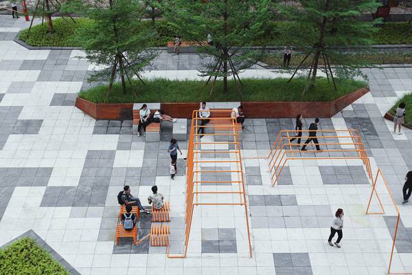
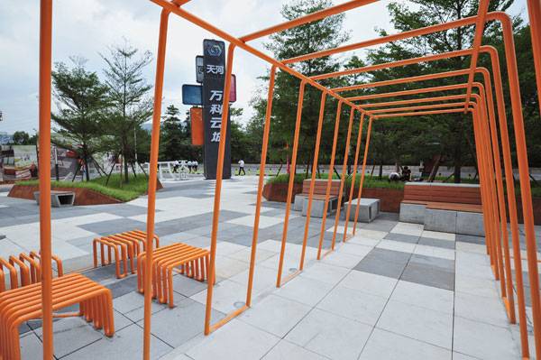
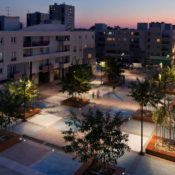
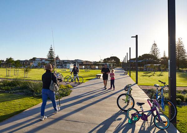
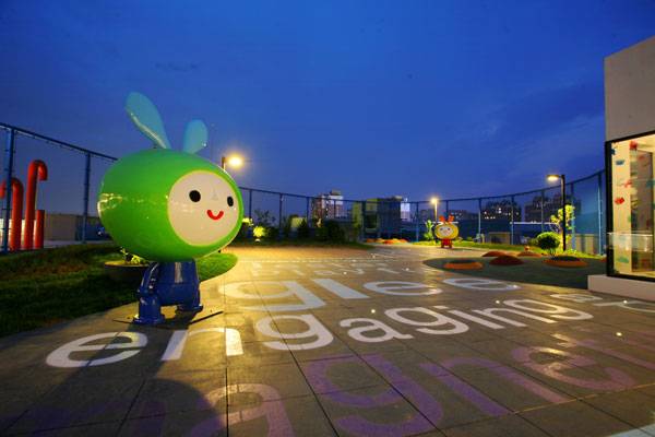
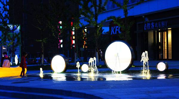
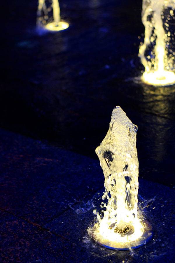
Article by Amrita Slatch – Vanke Cloud City Phase 2, by Lab D+H, in Guangzhou, China. It is very rare for mixed-use developments to cater to a specific group of people. But the Cloud City development by Vanke (China’s largest real estate developer) has taken the bold step of focusing on the younger generation, who come to live in extravagant first-tier cities such as Guangzhou, but wish to enjoy an affordable lifestyle. This project of 5,000 small apartments, combined with high-end retail areas, required a cohesive street infrastructure that would be interactive and add value to the space, but still be cost effective. It became essential for the developers to come up with an innovative solution. Considering the challenges involved, Lab D+H lab brought into the set-up to develop a strong landscape strategy.
Vanke Cloud City Phase 2 – Photo Credits: James Cheng
Vanke Cloud City
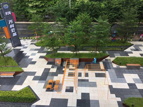
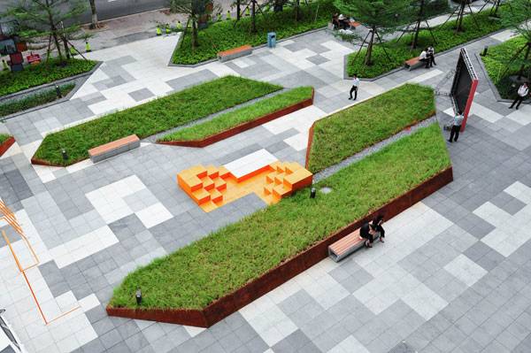
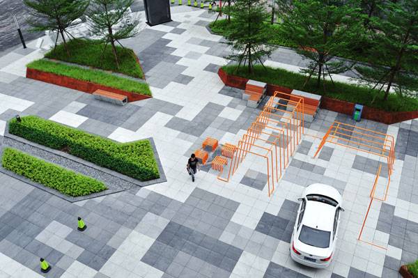
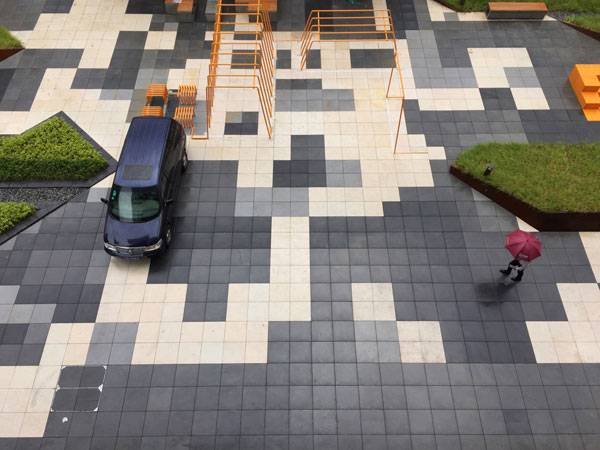
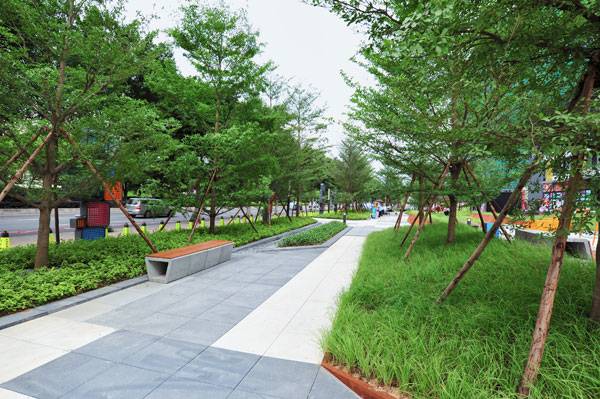
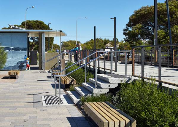
A Modular Floorscape that Generates a Framework for the Overall Landscape Environment
When we are striving to be cost efficient, we tend to work within the geometrical or Euclidean limit, as it is easier to construct, assemble, and replicate that model. To augment this or tweak it with various permutations and combinations can be tricky. To base the entire floorscape on this thought was an amazing idea, as it not only guided the two-dimensionality of the space, but also amplified the three-dimensionality of it. How was it done?
Vanke Cloud City Phase 2 – Photo Credits: James Cheng
Vanke Cloud City Phase 2 – Photo Credits: James Cheng
Vanke Cloud City Phase 2 – Photo Credits: James Cheng
Vanke Cloud City Phase 2 – Photo Credits: James Cheng
Vanke Cloud City Phase 2 – Photo Credits: James Cheng
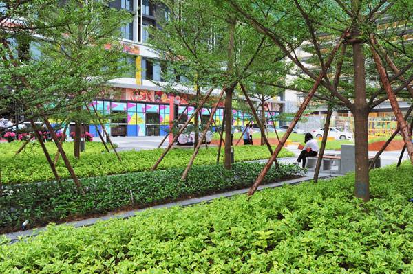
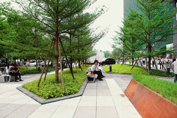
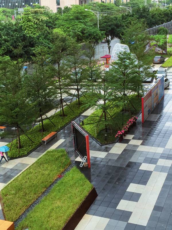
Softscape Spaces that Warm the Streetscape
Softscape areas that hold celebratory yet mellow landscape touches, such as a Christmas tree along with grasses and sedges, have been implanted within the floorscape, keeping the module in mind. The entire landscape looks to be part of one singular language despite the textural erraticism. In some places, they give a comfortable ambiance tucked behind seating areas; in others, they are bold gestures in and of themselves.
Vanke Cloud City Phase 2 – Photo Credits: James Cheng
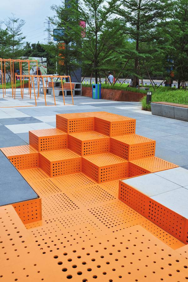
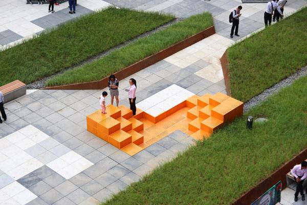
Dynamic Street Furniture for the Young and Restless
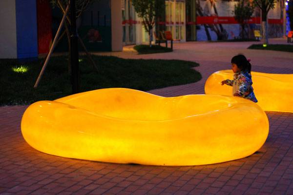
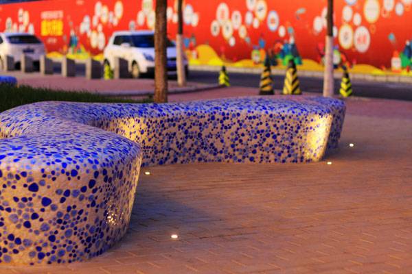
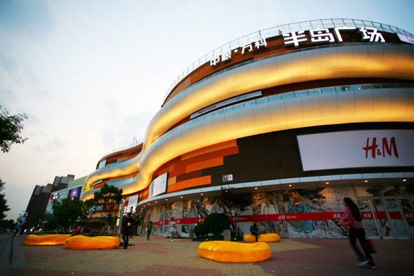
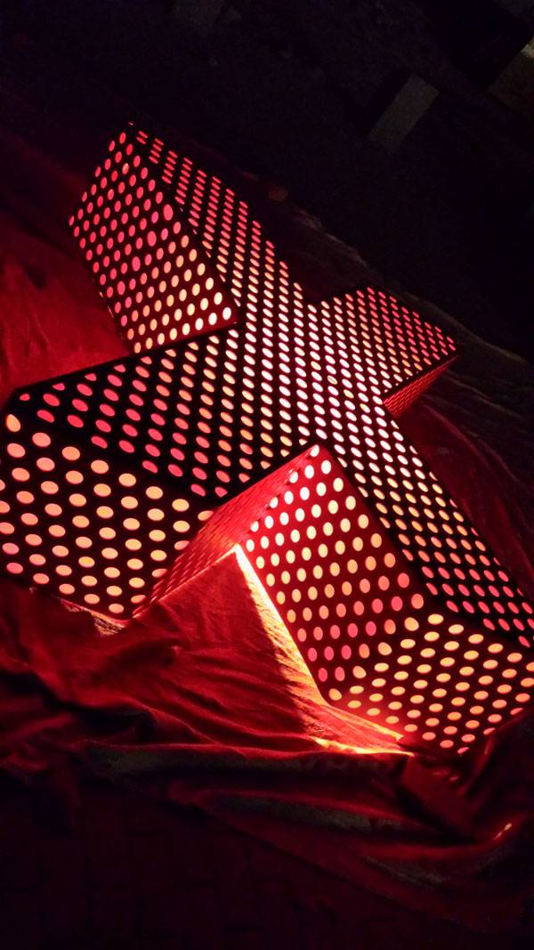
The street furniture follows similar modular principles. It is created using two basic precast modules that can be assembled with various permutations and combinations, forming 20 options. These options work differently as well, forming group seating, single seating, lounge seating, and so on and so forth. In this way, the furniture is dynamic and resonates with the younger market much better than what a stand-alone furniture set would do.
Vanke Cloud City Phase 2 – Photo Credits: James Cheng
Vanke Cloud City Phase 2 – Photo Credits: James Cheng
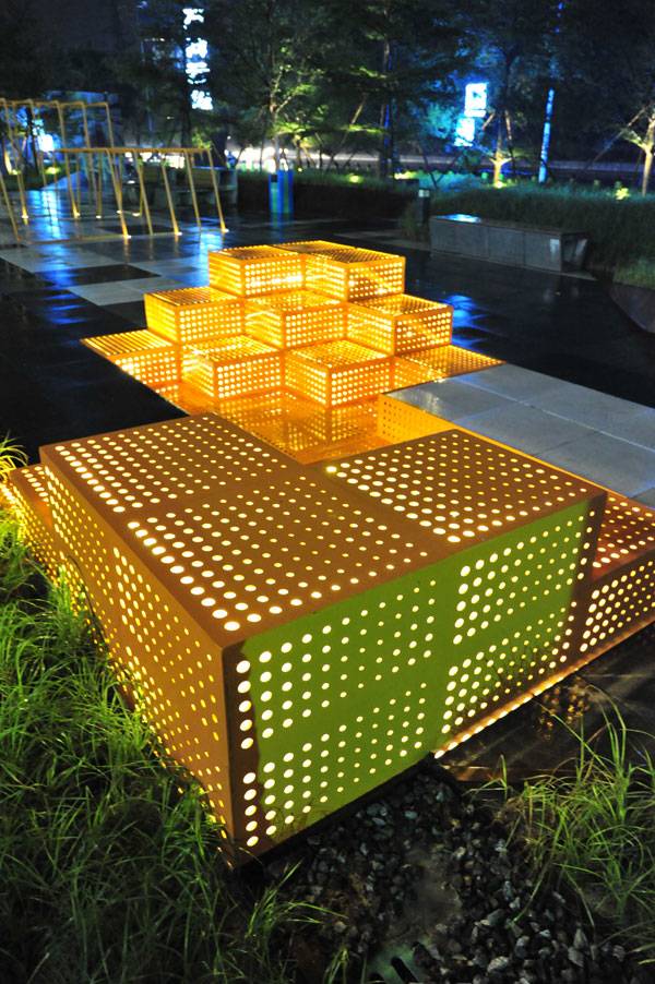
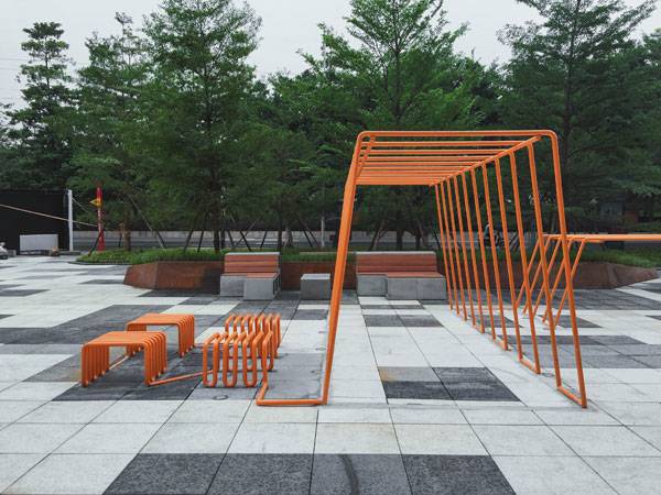
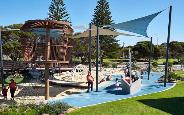
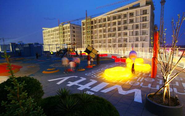
Interactive Landscape Installation for the Young and Energetic
To further enhance the streetscape, it was essential to add fun and interactive installations that make the space more active and invite residents to spend some time in recreation and physical activity. A cloud line made up of tubular steel runs and bends continuously throughout the space, forming monkey bars, benches, and other fitness facilities.
Vanke Cloud City Phase 2 – Photo Credits: James Cheng
Vanke Cloud City Phase 2 – Photo Credits: James Cheng
Living in an Urban Delight
All in all, Vanke Cloud City supports an amazingly livable environment for the young, thanks to Lab D+H, which has so cohesively crafted the environment, keeping all of the linkages intact despite the challenges involved. The design very boldly works on a modular framework strategy for the floorscape, from which the landscape literally emerges.
Vanke Cloud City Phase 2 – Photo Credits: James Cheng
Vanke Cloud City Phase 2 – Photo Credits: James Cheng
Vanke Cloud City Phase 2 – Photo Credits: James Cheng
Full Project Credits For Vanke Cloud City:
Project Name: Vanke Cloud City Phase 2 Project Location: Guangzhou, China Client: Guangzhou Vanke Landscape Architect: Lab D+H Design Team: Huicheng Zhong, YoungJoon Choi, Zhongwei Li, Jin Huang, Miao Lin, Liujun Deng, Nan Lin, Feimin Song, Hao Lan, Qin Zan Design/Construction: February-May 2016 Site Area: 4,000 square meters Photo Credits: James Cheng Recommended Reading:
- Becoming an Urban Planner: A Guide to Careers in Planning and Urban Design by Michael Baye
- Sustainable Urbanism: Urban Design With Nature by Douglas Farrs
- eBooks by Landscape Architects Network

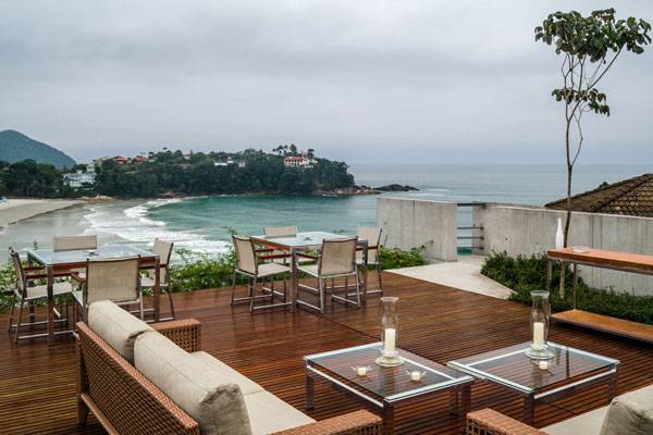
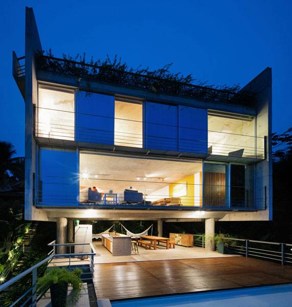
Ubatuba House II | When Architecture Completes Nature
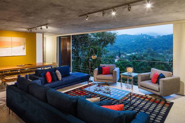
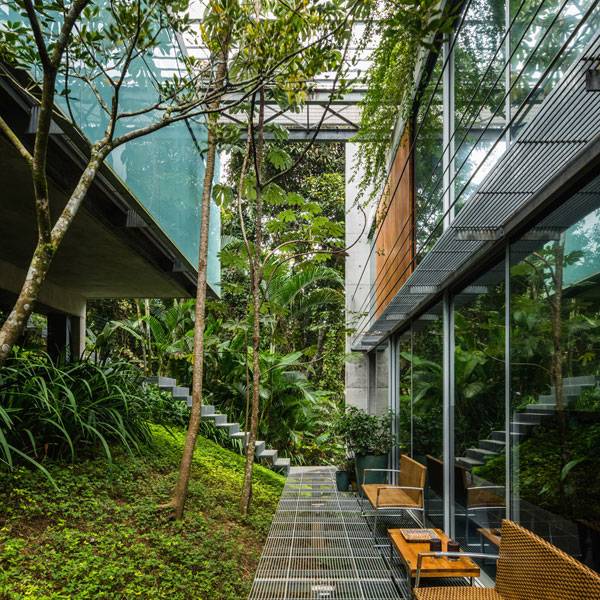
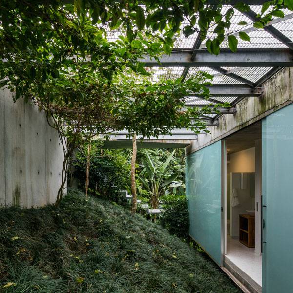
Article by Claudia Corapi – A walk inside Ubatuba House II by Spbr Architects, Ubatuba, Brazil. Urban planning has to ensure the right use of the land, but sometimes its rules interfere with creating a project that can also be viewed as a piece of art. The task taken up by SPBR Architects with the “Ubatuba House II” project wasn’t easy because of the necessity to preserve the surrounding site, made up of a forest of trees. Nevertheless, referring to the “Ubatuba House I” project experience, designed almost ten years before, they were soon able to turn two limitations – the urban rules and the sloping area – into key factors. “The hill on which is placed the house and the lush vegetation growing, are protected by environmental laws”, Angelo Bucci commented about Ubatuba.
Ubatuba House II. Photo Credit: Nelson Kon
Ubatuba House II
A Refined Landmark
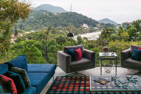
It’s really possible for a private house to become an element of public utility and “Ubatuba house II” shows how that can be. SPBR’s main purpose was to show the way in which concrete and nature can coexist while also creating a house that is a showpiece for the community and a possible tourist destination. Ubatuba House II also has an amazing landmark role because it looks like an iconic architecture which admires and, above all, is admired.
Ubatuba House II. Photo Credit: Nelson Kon
Ubatuba House II. Photo Credit: Nelson Kon
A Professional Challenge
Who among designers, at least once in a lifetime, has felt frustrated, facing boring rules? In this case, finding a balance between the natural environment and the built environment could have proved frustrating for the design team.
Ubatuba House II. Photo Credit: Nelson Kon
Ubatuba House II. Photo Credit: Nelson Kon
A Delicate “Family Nest”
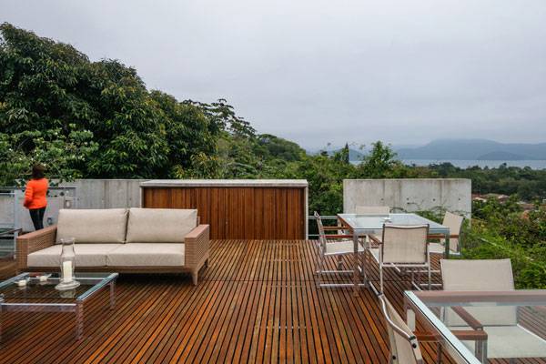
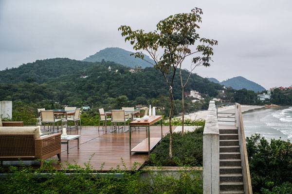
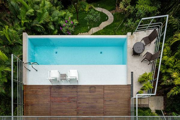
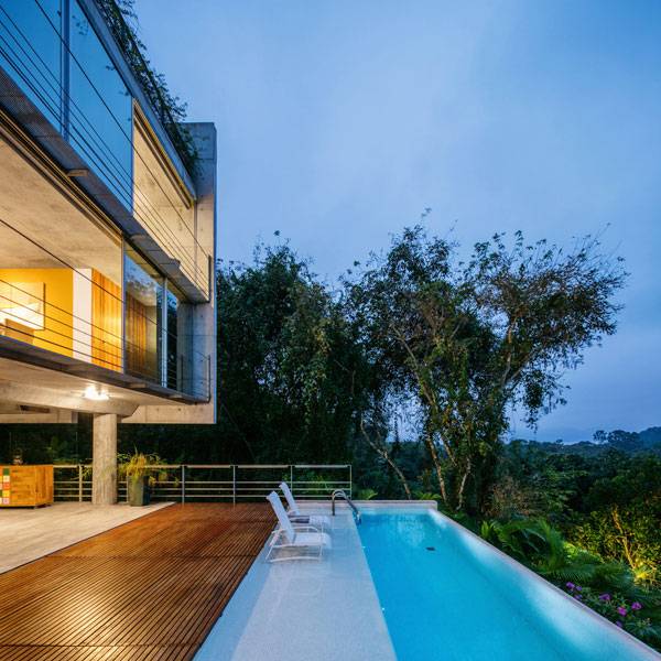
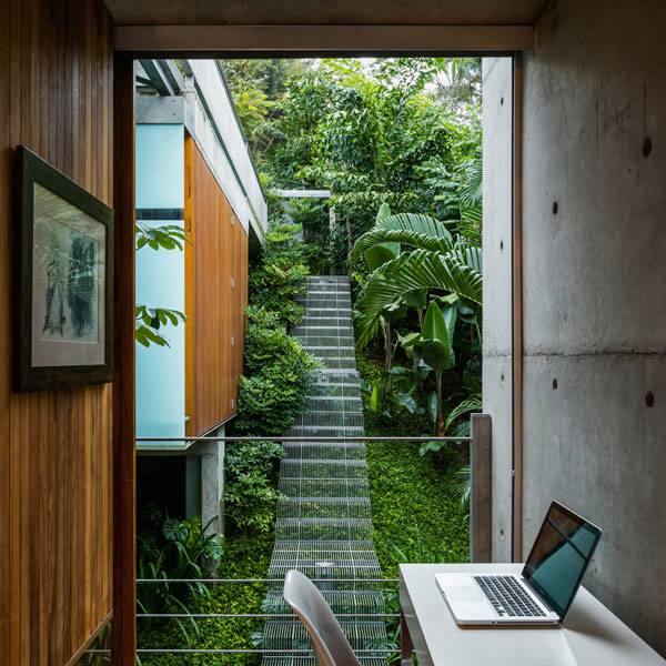
It’s located in Ubatuba, on the São Paulo Brazilian coast, where fascinating legends of pirates makes its history a past to celebrate and preserve. The 350,40 m² house occupies 50% of the sloping land but its pillars are the only elements to rest on the original site.
Ubatuba House II. Photo Credit: Nelson Kon
Ubatuba House II. Photo Credit: Nelson Kon
Upside-down Composition
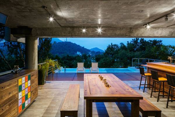
From the top, a bridge connects the entrance to the street and it also creates the starting point of an ideal path through the house. Residents are able to enjoy both the indoors and outdoors since the bridge eventually leads them through the trees that surround the house to an elegant balcony overlooking the sea. Well-furnished as an open-air lounge bar, you can stop and sit, relax, and enjoy the landscape, or you can simply pass through and enter the house via the access stairs.
Ubatuba House II. Photo Credit: Nelson Kon
Ubatuba House II. Photo Credit: Nelson Kon
Two “Satellite” Volumes
The residence of the keeper is the west “satellite” volume, located immediately below the main entrance; it has its own services and a separate entrance with rooftop parking, allowing for privacy and discretion. The east cube is a space conceived as an “extension” of the house with a pool. The designers didn’t want to interfere with the beauty of their surroundings, so they discreetly hid the pool equipment in an area under the pool. The light helps to underline these three cubes: by penetrating through the slits it emphasizes the relationship between full and empty spaces.
Ubatuba House II. Photo Credit: Nelson Kon
Clever Engineering and Materials Elegance
The structure of reinforced concrete columns was completed by wood elements and frameless tempered glass. The warmth of the wood adds depth to details like doors, furnishings and the pool. The inside floor is coated by 2.5×2.5 cm ceramic tile, while metal was chosen for railings and secondary external stairs. Colors contribute to give a sense of imitation of the surrounding nature: the parallel between the grey sand and the walls, the harmony between the forest and the brown frames, the dialogue among the water pool and the blue sea, as if it were an artificial representation of the natural environment.
Ubatuba House II. Photo Credit: Nelson Kon
Harmonious Relationship Between Nature and Artifice
Urban rules, such as connections between the users’ needs and the designer’s artistic sensibility, must always be considered. This project shows though, that neither has to win if there is way to make them work in harmony with each other. What elements could have been added or left out to make this design fit into the environment even more?
Ubatuba House II. Photo Credit: Nelson Kon
Full Project Credits for Ubatuba House II:
Project title: Ubatuba House II Location: Ubatuba, São Paulo, Brazil Design years: 2011-2012 Construction years: 2013-2014 Architectural firm: Spbr Architects Principal in charge: Angelo Bucci Project team: Tatiana Ozzetti, Nilton Suenaga, Ciro Miguel, Juliana Braga, Fernanda Cavallaro, Victor Próspero Scope: Design a private house Client: Wanda Antunes, Celso Antunes Structural engineer: Marcelo José Bianco, Ricardo Bozza (Inner Engenharia) Photo: Nelson Kon Plumbing / electrical: JPD Landscape architect: Raul Pereira General Contractor: José Bernardino E. de Sousa Structural system: Reinforced concrete Major materials: Concrete, glass, wood, steel Site area: 887,50 m² Total floor area: 350,40 m² Recommended Reading:
- Becoming an Urban Planner: A Guide to Careers in Planning and Urban Design by Michael Baye
- Sustainable Urbanism: Urban Design With Nature by Douglas Farrs
- eBooks by Landscape Architects Network

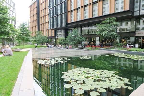
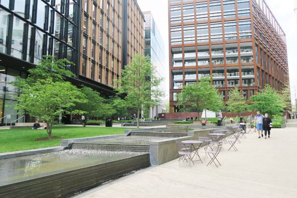
New Urban Squares | How to Activate the Leftover Spaces Between Buildings
Article by Giacomo Guzzon – The Case of St. James Square in Melbourne and Pancras Square in London looking at how they created new urban squares. Almost all historic public squares have some common characteristics. They are typically generous in size, they are often surrounded by important buildings, feature fountains, statues, and seating of some kind, and most importantly, they have lots of light because they are surrounded by rather low buildings, hosting shops and restaurants and conveying a liveable and active atmosphere. Today urban squares are designed in a completely different socioeconomic environment. Space in cities is limited and there is great economic pressure to create tall buildings to maximize their capacity and use.
Pancras Square. Photo credit: Giacomo Guzzon
Pancras Square. Photo credit: Giacomo Guzzon
New Urban Squares
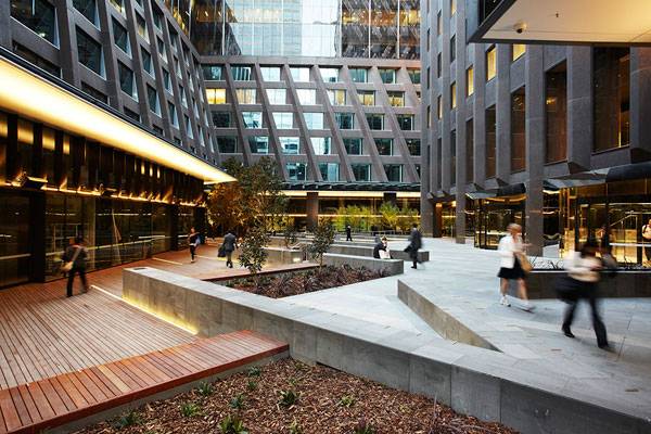
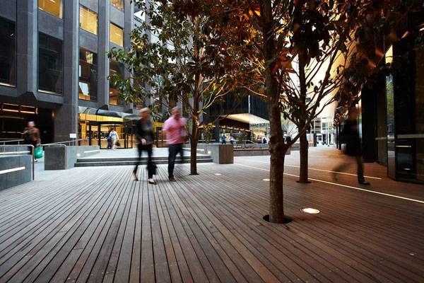
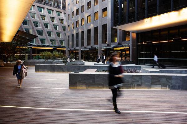
St. James Square in Melbourne
St. James Square, by Aspect Studios, covers a small site completely surrounded by tall and modern buildings. Here the design had the goal to activate and rejuvenate the public realm that was left after renovating a 1960s building. The open space design has a strong connection with the architecture’s forms and diagonal lines; these are reflected onto the square and used to shape and orient retaining walls, planting beds, and to align trees.
St. James. Photography: Andrew Lloyd
St. James. Photography: Andrew Lloyd
St. James. Photography: Andrew Lloyd
St. James. Photography: Andrew Lloyd
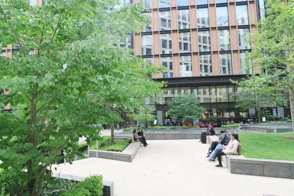
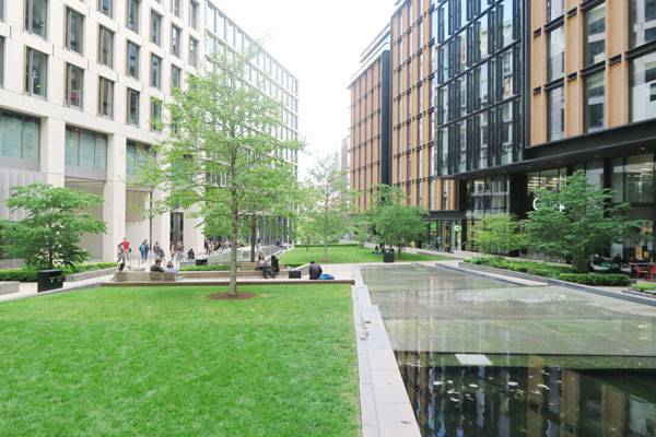
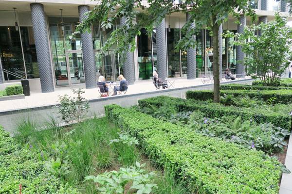
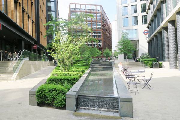
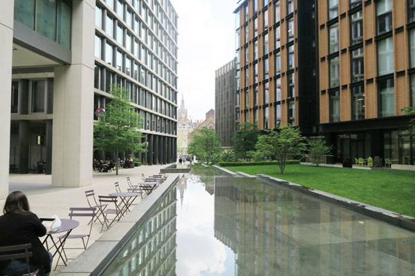
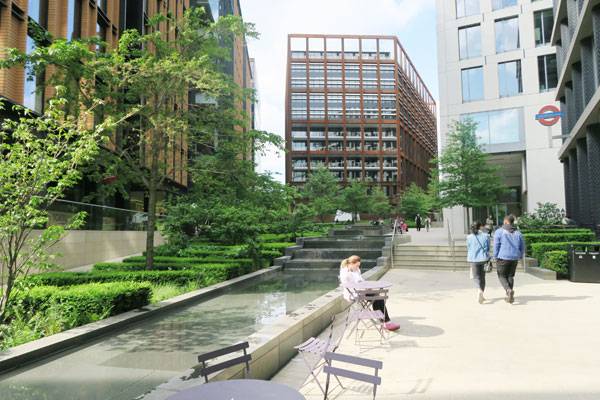
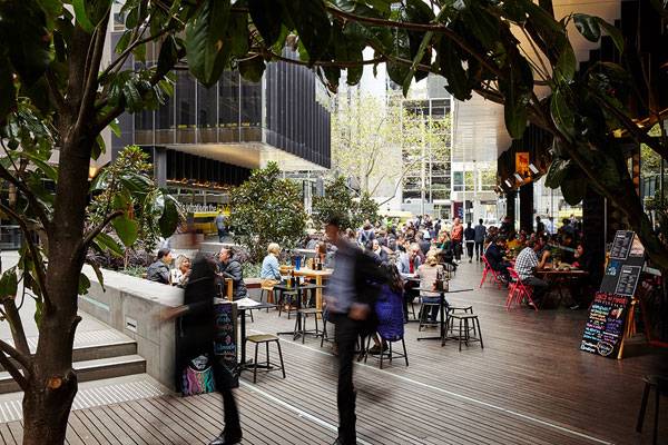
Pancras Square, London
Pancras square, by Townshend Landscape Architects, is located within a larger masterplan for the redevelopment of an area next to King’s Cross Station in London. The site has many similarities with the one in Melbourne: it is rather small, surrounded by new and tall buildings, and it has a modern atmosphere. The 4000m2 square is composed of different terraces sloping down from north to south and following the natural relief.
Pancras Square. Photo credit: Giacomo Guzzon
Pancras Square. Photo credit: Giacomo Guzzon
St. James Square. Photo credit: Giacomo Guzzon
Pancras Square. Photo credit: Giacomo Guzzon
Pancras Square. Photo credit: Giacomo Guzzon
Pancras Square. Photo credit: Giacomo Guzzon
St. James. Photography: Andrew Lloyd
St. James. Photography: Andrew Lloyd
Full Project Credits:
Project Name: St. James Square Client: Juilliard Group Team: ASPECT Studios (Landscape Architects and Lead Consultants) METIER3 (Architects) Bonacci (Structural and Civil Engineering) Vision Design (Lighting Design) Location: Melbourne, Victoria, Australia Year: 2013 Budget: AUS $1.2 million Area Size: 2,500 m2 Photography: Andrew Lloyd – Project Name: Pancras Square Team: Townshend Landscape Architects, Robert Townshend, Martha Alker, Andrea Dates Fountain Designer: The Fountain Workshop Year: 2015 Location: Pancras Square, King’s Cross, London, UK Client: King’s Cross Central Limited Partnership Area size: 0.4 ha Recommended Reading:
- Becoming an Urban Planner: A Guide to Careers in Planning and Urban Design by Michael Baye
- Sustainable Urbanism: Urban Design With Nature by Douglas Farrs
- eBooks by Landscape Architects Network


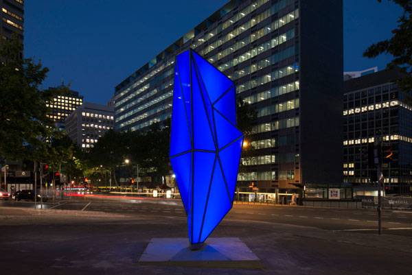
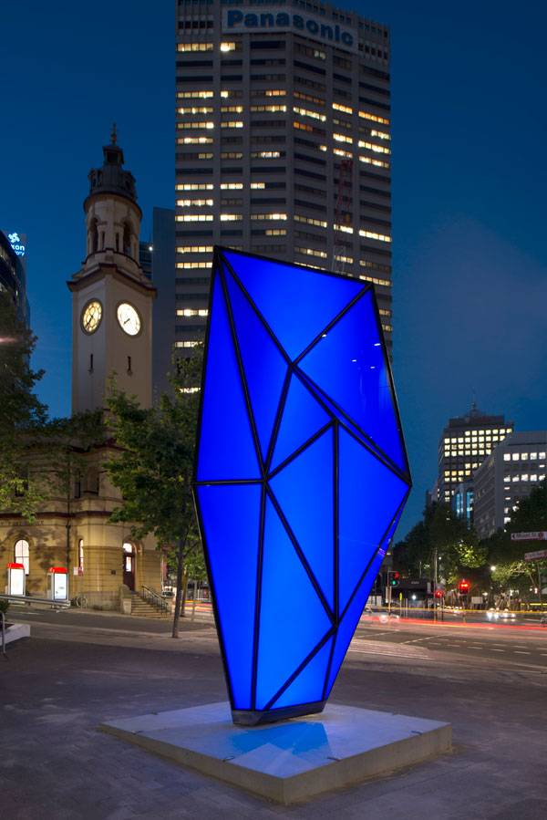
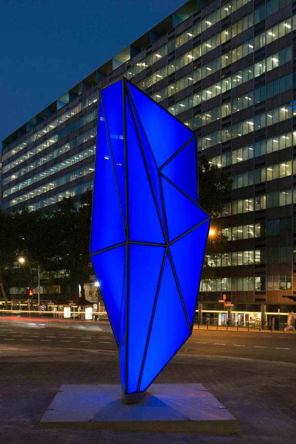
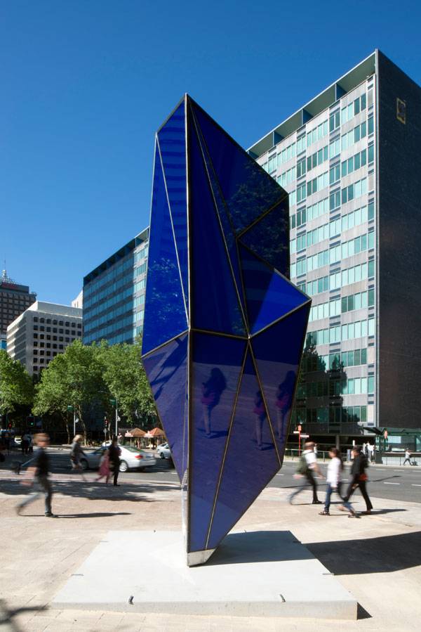
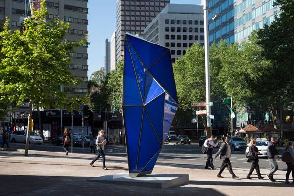
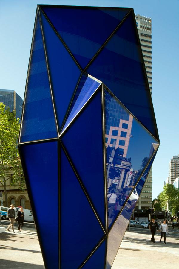
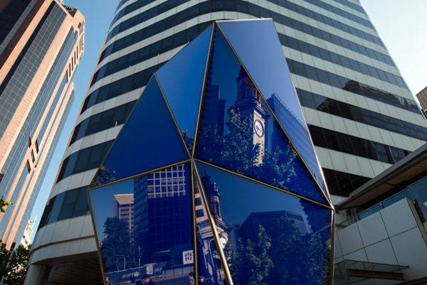
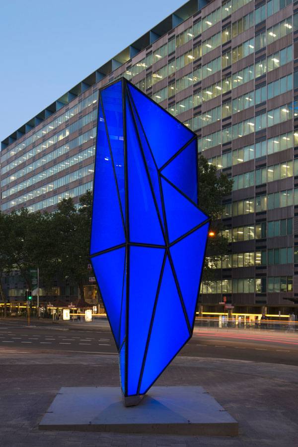
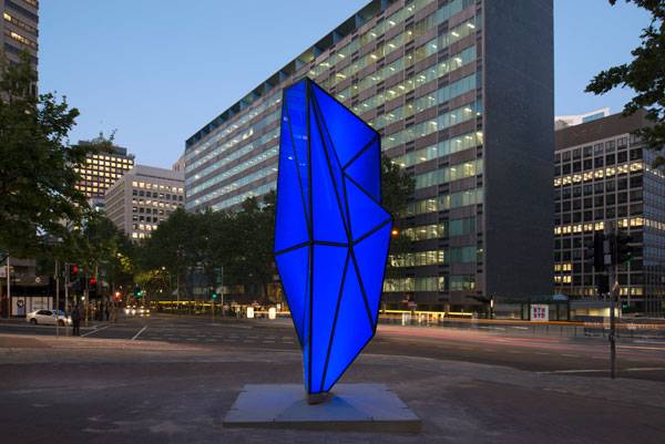
Angles of Incidence | Blue Artistic Landmark Glows in Sydney
Article by Alexandra-Elena Ciocan – Angles of Incidence, by Warren Langley and Julia Davis, in Victoria Cross, North Sydney, Australia. The 6-meter high, imposing and curious sculptural landmark created by famous artist-couple Warren Langley and Julia Davis in the Victoria Cross intersection, North Sydney, required tremendous thought and sentiment, as well as thorough artistic and engineering study. The Angles of Incidence project is part of the North Sydney Public Art Trail, consisting of this and 17 other pieces scattered in different locations all over Sydney, with the major purpose of providing visitors with a high-quality public art experience.
Angles of Incidence. Photo credit: Richard Glover
Angles of Incidence
This project shows that artists need to utilize much more than just materials or colours in order to conceive of something eye-catching and modern. They must also work with light, texture, and the surrounding landscape, in order to create a true landscape masterpiece.
Angles of Incidence. Photo credit: Richard Glover
Pulsating with the Rhythm of the City
The glass artwork is definitely a statement piece that has a dynamic influence on the environment, but from our point of view, it is also well-integrated into its surroundings. By these means, it becomes a component and a living structure of the busy city. This glass-and-light canvas is ideal for painting all the images and capturing seconds and memories of the rapid flow of life.
Angles of Incidence. Photo credit: Richard Glover
Angles of Incidence. Photo credit: Richard Glover
Narrating the Specificity of the Site
As much as this blue beacon has a silent personality it also makes a strong impression. The shape it resembles is truly site-specific, as the inspiration for the final form was no other than a small quartz grain from the underlying city layers. The anatomy of the artistic piece echoes the site’s past and its reflective surface provides insight into the present. According to what Davis says, “The dialogue between the sculpture and its surroundings is a metaphor for the ‘interactions’ that have happened on this site from its pre-colonial past to the commercial and entertainment precinct it is now.”
Angles of Incidence. Photo credit: Richard Glover
Angles of Incidence. Photo credit: Richard Glover
Entertaining Despite its Static Nature
The very piece was born at the crossing of interactive safety glass planes, falling and rising at different angles, and while the notion of an interactive land sculpture might not be new in the field of environmental art, I assure you that this one is different. While other sculptures are interactive as a consequence of their movement mechanisms that are engaged by wind or water, this glass piece is distinct.
Angles of Incidence. Photo credit: Richard Glover
Angles of Incidence. Photo credit: Richard Glover
Angles of Incidence. Photo credit: Richard Glover
Full Project Credits For Angles of Incidence:
Project Name: Angles of Incidence Artists: Warren Langley and Julia Davis Project manager: Trent Baker Armature Structural Engineers: Harry Partridge and Niki Akbari Commissioned: North Sydney Council Location: Victoria Cross, North Sydney, Australia Dimensions: 6m H x 2.4 x 2.2 Completed: 2016 Type: Light and Glass sculpture Title: Angles of Incidence Materials: Digitally coloured safety glass, stainless steel and LED lights Photo Credit: Richard Glover Recommended Reading:
- Becoming an Urban Planner: A Guide to Careers in Planning and Urban Design by Michael Baye
- Sustainable Urbanism: Urban Design With Nature by Douglas Farrs
- eBooks by Landscape Architects Network


Landscape Architecture Plan | 10 Excellent Video Tutorials
Article by Gwgw Kalligiannaki – We take a look at 10 incredible YouTube tutorials for creating a landscape architecture plan to improve your skills. The landscape architecture plan is a communication document. We create them to visualize our ideas to other people. However, we live in the age of publicity, so the plan is also part of the architect’s professional image. As the competition grows, most of us spend lots of hours in front of our computers not only for ‘cadding’, but also for illustrating our plans. I really love editing, paying attention to the line weights, using textures for the different materials, using symbols, in order to form a more aesthetically interesting landscape architecture plan. Fortunately, we can easily find a variety of video tutorials for editing, and tips to speed up the illustrations. It’s important to know what you should highlight, in order not to distort the information that the landscape architecture plan must give. So, I created for you a list of 10 video tutorials that I watched to improve my editing skills, but also to save time during the editing process. I hope you find them as interesting and helpful as I do.
Creating a Landscape Architecture Plan
10. Drawing Trees
During the design progress we usually use drawings, before we start “cadding”. But have you ever thought about using the hand-drawn trees in your final plan? Well, now you will think, ‘why draw my trees when I can find a thousand blocks online?’. Drawing your own trees will be more interesting as you scan them and convert them to your own Photoshop brushes (you will see a ‘how to’ video below), or .png files for illustrations.
9. Creating Groups of Plants
Group plants in landscape architecture plans are usually used to represent bushes or groups of flowers. With simple tools; a pencil and a stencil with circles, we can create our own groups. As I said above, by editing your hand-drawn plants in Photoshop you can make brushes or .png images to use in your future design plans.
8. How to Model Detailed Terrain in SketchUp
This tutorial teaches you to create an embossed ground, fully detailed, using the location and terrain tools. This method is based on the location information from Google to create the landscape contours. It seems to help a lot, having a more realistic terrain with which to illustrate the landscape architecture plan. Used by thousands of architects in 3d design, it was time for SketchUp to include tools to create the topography of a site.
7. Preparing the Plan for Photoshop
This video was one of the first videos that I came through as I was searching tutorials. It doesn’t actually show an illustration method; it shows all the preparation, before importing the landscape architecture plan into Photoshop. The illustration becomes faster when you have set layers for materials, the units of the design, or have all the elements of the landscape architecture plan as polylines. I have to say that when I started to use this method, things become easier in Photoshop.
6. Creating Seamless Textures
A landscape architecture plan almost always contains continuous areas of grass or pavements. As we use textures to our plans, we are usually reaching for seamless textures, images that can be placed side-by-side with themselves without creating a noticeable boundary between two copies. It is useful to know how we convert a simple image to a seamless texture, to avoid the appearance of distracting seams in our plan.
5. Rhino Topography from Contours
Rhino is one of the most-used 3d visualization programs nowadays. Watching this tutorial, you can understand how to create a site’s topography from contours. Some of us find it a bit hard in illustration when we face areas with gradients. And once the ground is the basis of our design, we cannot overlook the topography when creating a landscape plan. Programs such as Rhino make the simulation of topography a lot easier. 4. Graphics For Landscape Design
We usually want to pay so much attention to our plans that we tend to overdo. We are not artists; the design plans are documents that help us communicate our ideas. “Graphics for Landscape Architects” mentions the important key points of the landscape architecture plan, such as line weights, colors, plantings, and trees and paving.
3. Using Photoshop Brushes
Watching this video, the first thing that came to my mind was the countless hours I have spent searching the Internet for high-quality .png files of plants for my plans. Now, Photoshop brushes are extended, so they include many more ‘stamps’ such as plants, people figures, or animals. Watch out; this tutorial actually starts at 3:00.
2. Creating Custom Brushes in Photoshop
Even if we can’t find the brush that we want, my beloved Photoshop gives another solution…create one! Photoshop now allows you to use images to create your own brush collection. I find this command so helpful, especially for plants, because it makes the illustrating process faster without the stress of quality, since the quality is adapted during design. I find this command so helpful, especially for plants, because it makes the illustrating process faster without the stress of quality, since the quality is adapted during design.
1. Landscape Architecture Section and Plan in Photoshop
I usually work with combined floor-section plans. I think that they make the whole idea of the design more clear. In this tutorial, even though the illustration is done without a CAD background, it gives all the information needed for this design. While watching the floor plan we can easily understand the layout of the elements, and the section above shows not only the planting and lighting, but also how they relate to human scale. As I’ve already said, I am an illustrated-plans lover. Watching all these tutorials (and many more as I work on my designs), I feel that the presentation of the design plan becomes part of the total design process. Not only are the editing programs, like Photoshop or Illustrator, improving their “skills” to offer more editing features, but the design programs now contain display element tools. What tools do you use in your landscape architecture plan illustrations?
Recommended Reading:
- Becoming an Urban Planner: A Guide to Careers in Planning and Urban Design by Michael Baye
- Sustainable Urbanism: Urban Design With Nature by Douglas Farrs
- eBooks by Landscape Architects Network


Zhangjiajie Pour | The Most Illusionistic Project you Have Ever Seen
Article by Radenka Kolarov – Zhangjiajie Pour, by Martin Duplantier Architectes, in Zhangjiajie, Hunan Province, China. Zhangjiajie Pour project by Martin Duplantier Architectes and Daqian Landscape Architects, in Zhangjiajie, China. This new stainless steel bridge is part of an award-winning concept designed by Martin Duplantier Architectes for the Zhangjiajie World Heritage Site in China. Landscape design for a World Heritage Site is all about treading lightly. And the latest concept for the Zhangjiajie World Heritage Site in Hunan Province, China, does exactly that. Martin Duplantier Architects has released its award-winning plans for pavilions and three scary bridges that will link mountain peaks via a new walkway in the wilderness.

Zhangjiajie Pour. ©Martin Duplantier Architectes
Zhangjiajie Pour
Form, Shape and Structure Three pavilions will be set in the park, offering incredible views to the visitors. Pavilions in the same materials are organized in three levels; from the 360° panorama on the roof – a terrace-panorama directly accessible from the path, to the café in the middle with its dedicated spaces, down to the exclusive VIP suite in the lower level – a royal guesthouse that offers a unique space of contemplation in the heart of the national park; the latter being the visitor’s only means to enjoy a unique night in the middle of this magical landscape. These incorporate space for a terrace, a cafe and a luxury guest house. “After the crowds of the day having disappeared, the lucky tenants will be able to enjoy the spectacle in perfect solitude,” the architects say. Those pavilions are connected with a very special bridge. Set down on the rocks, this step-bridge has two levels to be enjoyed. The upper one connects the two sides, while the lower one is for experiencing a moment “in the air”.

Zhangjiajie Pour. ©Martin Duplantier Architectes

Zhangjiajie Pour. ©Martin Duplantier Architectes
Concept of an Illusion
The concept developed is that of illusionistic geometric development. They are the opportunities, each in its own respect, to create a physical relationship with this rock face. The company’s concept, which was a competition entry, plays on the idea of illusion and stealth; the illusion of a mirror for the first, the fear of the void for the next, and lastly the setting of an abyss for the final.

Zhangjiajie Pour. ©Martin Duplantier Architectes

Zhangjiajie Pour. ©Martin Duplantier Architectes
Another Jewel of China
Zhangjiajie Pour is a project by Martin Duplantier Architectes and Daqian Landscape Architects in the city of Zhangjiajie. The project is located in the Zhangjiajie National Park which is one of the most important natural wonders of the country and it is a true geological museum of China. If this has made you want to go straight to Zhangjiajie we recommend that you might prefer the period of September through October. You will enjoy a pleasant time while you enjoy a refreshing landscape and these astonishing pavilions connected with the remarkable bridge in the center of Zhangjiajie National Park. Would you be brave enough to visit such a place as a Zhangjiajie Pour? Let us know in the comment section below!
Full Project Credits For Zhangjiajie Pour:
Project Name: Zhangjiajie Pour Location: Zhangjiajie, Hunan Province, China Client: ZTG Dates: Winner of the 2015 International Competition. Construction periods should be done in 2018. Landscape Architects: Martin Duplantier Architectes, Daqian Landscape Architects Recommended Reading:
- Becoming an Urban Planner: A Guide to Careers in Planning and Urban Design by Michael Baye
- Sustainable Urbanism: Urban Design With Nature by Douglas Farrs
- eBooks by Landscape Architects Network


Amsterdam Canal Ring | How Amsterdam Became one of the Most Sustainable Cities in the World
Article by Ophelia Yuting Ji – We take a look at how Amsterdam became one of the most sustainable cities in the world due to the development of the Amsterdam Canal Ring. Revolving windmills, blossoming tulips, and meandering canals; we are all drawn to the beautiful sightseeing in Amsterdam, but the capital of the Netherlands is definitely more than that. The city, located in the North Holland province in the Netherlands, was derived from a fishing village along the Amstel River in the 13th century. The clue can easily be found in its name: “Amster-dam” basically means the dam around the Amstel River. Despite the fast development around this river and IJ Bay, Amsterdam has become one of the top 5 sustainable cities in the world, according to the Arcadis “Sustainable Cities Index” in 2015.
Photo Credit: Ophelia Yuting Ji
Photo Credit: Ophelia Yuting Ji
Amsterdam Canal Ring
In-Water Transportation
The whole city was developed along the canals made by careful city planning decisions. The water management in Amsterdam has a very long history. Beyond the water managing function, even before the 16th century, the canals were first used as a defensive moat. They gradually became used for commercial and residential uses, as well as for transporting merchandise, as it says in “Time Out Amsterdam”.
Photo Credit: Ophelia Yuting Ji
Photo Credit: Ophelia Yuting Ji
Photo Credit: Ophelia Yuting Ji
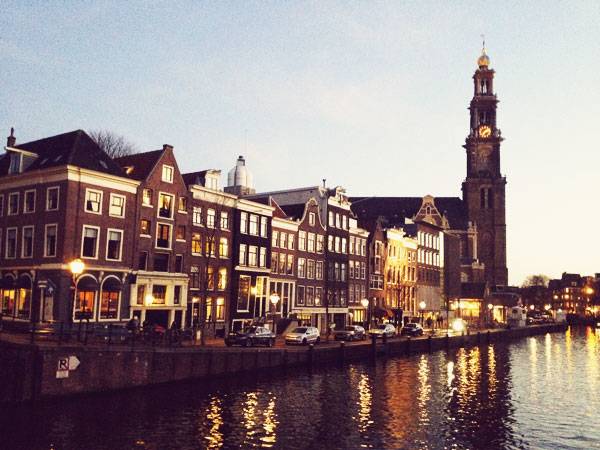
Photo Credit: Ophelia Yuting Ji
Windmill – Wind Power
Besides the water and electricity power usage, as is known, wind power technology is another advantage for the Dutch. According to iamsterdam.com, the Netherlands used to have 10,000 operational windmills for industrial purposes, and now there are 8 in Amsterdam. In fact, the windmills can not only be used to make flour from grain but also function to drain the lowlands of excess water to reclaim polders, press oil out of seeds, and saw wood. Nevertheless, the Dutch are obviously more enterprising in the new decade. Starting from January 1st, 2017, all electric trains are now powered by wind in the Netherlands, says Ton Boon, the spokesman for national railway company, NS.
Photo Credit: Ophelia Yuting Ji
On-Land Transportation
Walking in the city, you can always observe people riding bicycles as they flash by. With a population of 842,343 residents in August of 2016, based on the data from Centraal Bureau Voor de Statistiek (Central Bureau for Statistics) in Netherlands and a 21,949-hectare total surface area, based on the data from 2016 Jaarboek Amsterdam in Cijfers (Amsterdam Yearbook in Figures), the largest city in Netherlands has always been promoting their bicycling traditions. According to the City of Amsterdam, in the period from 2005 to 2007, residents used their bicycle an average of 0.87 times a day and their car 0.84 times.
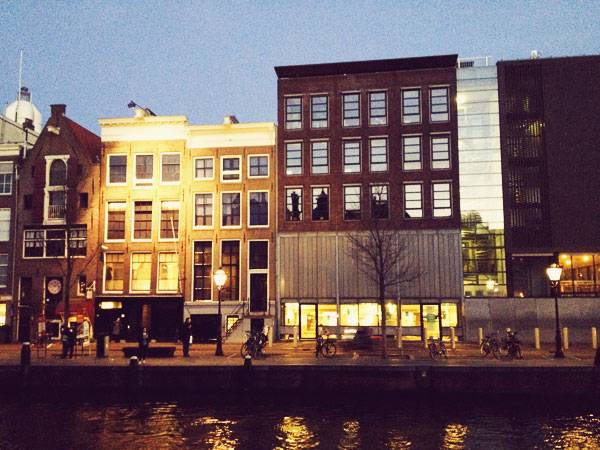
Photo Credit: Ophelia Yuting Ji
By understanding the multifaceted history in Amsterdam, we would appreciate all the efforts having been put into this land that make it such an inclusive place for people with different backgrounds and living rituals, and the courage of being a pilot in making a sustainable cityscape by embracing what they used to be afraid of and turning it into a great water resource for the city. Does this planning model of Amsterdam Canal Ring give you inspiration on what we can do to improve our city, to make it more sustainable and inclusive to diverse communities?
Photo Credit: Ophelia Yuting Ji
- Becoming an Urban Planner: A Guide to Careers in Planning and Urban Design by Michael Baye
- Sustainable Urbanism: Urban Design With Nature by Douglas Farrs
- eBooks by Landscape Architects Network


10 of The Best TED Talks to Inspire Landscape Architects
Article by Monika Roy – We take a chance to list 10 of the best TED talks we could find, that we feel will inspire landscape architects. For 33 years, the famous online platform TED has been simultaneously spreading newer and newer inspiring ideas about numerous technological and social breakthroughs going on around the world. Day by day, more people are getting interested in such passionate talks not only because of their brief lengths but also as these talks boost our creativity and broaden our perspectives. Here, we have presented 10 intriguing TED talks involved with landscape-related elements, materials, social integration, and city life. We believe these talks will inspire many landscape architects to follow their dreams in today’s challenging world!
10 of The Best TED Talks
1. Elora Hardy: Magical houses, made of bamboo – Over 2.5 million views
“Bamboo will treat you well if you use it right.”– Elora Hardy With the notion of the right nurturing of natural materials, sustainable designer Elora shares the enigmatic potential of using bamboo in the world. Since no two poles of bamboo are alike, therefore every little design point becomes unique. Her outstanding designs of bamboo structures array incredible ways of how to keep buildings in blend with natural landscapes. WATCH >>> Magical houses, made of bamboo | Elora Hardy
2. Amanda Burden: How public spaces make cities work – Over 1 million views
“Design is not just how something looks but it’s how your body feels on that seat in that space.”- Amanda Burden In this inspiring talk, Amanda sensibly points out that lively, enjoyable public spaces are the pivotal elements for planning a city. For a public space to be successful for the people living in the cities, the architect has to give enormous dedication to the details. Meaningful open spaces act like they have powers. She shares here, one of the very successful projects where she turned a degraded waterfront in Brooklyn into an incredible park with lots and lots of trees, plantings, and seatings where people love to wander. She also shares the unexpected challenges of planning parks while emphasizing that public spaces must never be taken for granted. WATCH >>> Amanda Burden: How public spaces make cities work
3. Michael Pawlyn: Using nature’s genius in architecture – Over 1.5 million views
“You could look at nature as being like a catalog of product”- Michael Pawlyn Greatly inspired by nature, Michael rediscovers 3 ways to build a new world of sustainability; radical resource efficiency in the Eden Project, linear to closed loops in the Mobius Project, and drawing energy from the sun in the Sahara Forest Project. He brilliantly shows that even waste, which is a big urban problem in cities, can also be turned into a massive opportunity! WATCH >>> Michael Pawlyn: Using nature’s genius in architecture
4. Theaster Gates: How to revive a neighborhood: with imagination, beauty, and art – Over 980k views
With the thought of reviving the use of abandoned buildings in his neighborhood as an expansion of artistic practice, the ambitious potter and social activist, Gates, came up with an idea of making community hubs. As he believes that culture can be a catalyst for social transformation in any city, his ultimate purpose is to build a “miniature Versailles” in Chicago. WATCH >>> Theaster Gates: How to revive a neighborhood: with imagination, beauty and art
5. Jeff Speck: 4 ways to make city more walkable – Over 975k views
Jeff Speck, the city planner famous for his general theory of walkability, shares 4 rational ways of how to transform a car-oriented city into a walkable one. Providing proper reasons for walking, ensuring safety, and making the walk comfortable as well as interesting should be considered together. He figures out that factors such as huge parking lots, height-to-width ratios, block sizes, unnecessarily-wide traffic lanes, etc. can be utilized to create walkable spaces full of bike lanes and tree-lined streets. WATCH >>> Jeff Speck 4 ways to make a city more walkable
6. Alex Steffen: The shareable future of cities – Over 970k views
By mentioning real-world examples of climate change and energy usage, planetary futurist Steffen shows us that a brighter, greener future is ours to choose. He dreams of the “Carbon Zero” cities, accelerating their economies while reducing their climate emissions to zero. For sake of saving the future, he gives importance not only to some cool neighborhood-based green projects but also to expanding our access to things we want and need while reducing the time we spend in cars. WATCH >>> Alex Steffen: The shareable future of cities
7. Dan Barasch: A park underneath the hustle and bustle of New York City – Over 840k views
In this short talk, strategist Dan Barasch gives us a brief of the project, “Lowline”. Together with his partner Ramsey, Dan is going to transform an abandoned trolley terminal into an underground park using innovative solar technology to capture light above the ground and make it a space filled with greenery that can be used for all seasons; even in winter! It is Dan’s intense desire of wanting to make a difference in a city like New York that makes it all possible. WATCH >>> Dan Barasch: A park underneath the hustle and bustle of New York City
8. Ryan Gravel: How an old loop of railroads is changing the face of the city – Over 760k views
Architect and urban planner Ryan changes the provincial view of infrastructure we perceive by mentioning that it is the foundation for our social life and culture. He shares his brilliant idea of urban revitalization by adapting an old railroad circling downtown in Atlanta, Georgia. He stunningly transformed the abandoned railroad track into 22 miles of public green space called the Atlanta BeltLine. It is changing the way people think about the city, he strongly feels. WATCH >>> How an old loop of railroads is changing the face of a city
9. Aziza Chaouni: How I brought a river, and my city, back to life – Over 640k views
Architect Aziza here shows us briefly how she is rehabilitating the Fez River, once considered the soul of its Moroccan city. In order to transform the river from sewage to public space for all, she is not only restoring its riverbanks and creating pedestrian pathways covered with trees but also shifting the illegal parking lots into playgrounds built with recyclable materials. It sets for us a pragmatic example of reviving a mortifying city into a living one. WATCH >>> Aziza Chaouni: How I brought a river, and my city, back to life
10. Carlo Ratti: Architecture that senses and responds – Over 640k views
Architect and director of MIT’s SENSEable City Lab, Carlo makes cool sensory things using passive data sets we use every day. He mentions a project where his team designed a water curtain with pixels of water in Spain. Another interesting project is the “digital water pavilion”, as he calls it. It’s a building made of water with no doors or windows but the water façade would open up to let one in. This has been possible because of the innovative use of sensors. He thus opens up a new door of using the technology before us which has the potential of creating many interactive public spaces throughout the city. WATCH >>> Carlo Ratti: Architecture that senses and responds
Let us know which talks excite you most!
Recommended Reading:
- Becoming an Urban Planner: A Guide to Careers in Planning and Urban Design by Michael Baye
- Sustainable Urbanism: Urban Design With Nature by Douglas Farrs
- eBooks by Landscape Architects Network

How a Mournful Old Square Turned into a Dynamic, Vibrant Plaza
Article by Farah Afza Jurekh – A review of the vibrant plaza at Place des Droits de l’Homme, by B+C Architectes , Tremblay-en-France. The urban squares are like magnets to cities. The magnetic forces that the city square possesses depends highly on the design of the square. An unused, forgotten, mournful space can be easily turned into a dynamic, attractive, vibrant place if it is designed creatively and meticulously by architects. Place des Droits de l’Homme, located in Tremblay-en-France, designed by B+C Architectes, is one such project which has turned an old, unused square into one of the most attractive, living spaces of the city.

Place des Droits de l’Homme. Credit: B+C Architectes
Place des Droits de l’Homme Vibrant Plaza
The Site, its Context, and its Importance
The site of the vibrant plaza project, or its context, dictated a lot in the design process. Place des Droits de l’Homme is located in a very significant portion of the city. Being enclosed by civic, cultural, and residential buildings, the rehabilitation of the square demanded that it be very lively and open.

Place des Droits de l’Homme. Credit: B+C Architectes

Place des Droits de l’Homme. Credit: B+C Architectes
Permeability in Planning
As a pivotal place of the city, connectivity is undoubtedly an essential factor for this particular vibrant plaza project. Hence, from an urban design approach, the design team at B+C Architectes intervened to make the square more permeable, bringing an openness in plan so that the square can be a nodal point connecting the surroundings seamlessly with the urban fabric. Therefore, the design team stated that they have worked on both the ‘horizontal and vertical interfaces’ of the square to ‘open up’ the place.

Place des Droits de l’Homme. Credit: B+C Architectes
The Design Approach; to Make the Square Accessible to All
Since the main idea was to open up the square in order to mend the broken connections, it was necessary to make it accessible to the city dwellers from all nodal points. As mentioned before, the square was raised above ground level, so it was important to make it accessible from all directions. Firstly, le Jardin des Cultures, located to the south of the square, was connected through the introduction of a generous staircase.

Place des Droits de l’Homme. Credit: B+C Architectes

Place des Droits de l’Homme. Credit: B+C Architectes
The Dynamic and Vibrant Checkerboard Square
So we all understand that only making it accessible from all points will not make the square a lively place. The ramps and staircases certainly made the square accessible from vertical surfaces, but the horizontal facets of the square also needed to be taken care of. The old paving slab of the square, which became risky due to overloading, was replaced by concrete squares, making it a safer place.

Place des Droits de l’Homme. Credit: B+C Architectes

Place des Droits de l’Homme. Credit: B+C Architectes
The Micro Gardens
The use of concrete pavers amidst the concrete jungle was equalized by introducing biomass — the micro gardens. A richer diversity of trees and plants, starting from deciduous trees like maple and a variety of flowering species, along with evergreens, are inserted in the micro gardens. The micro gardens were arranged to take up 4 ‘pixels’ of the checkerboard. Since the square was aimed to house multiple events, it was a great idea to design mobile micro gardens; these micro gardens can be transported by forklifts depending on the occasion.

Place des Droits de l’Homme. Credit: B+C Architectes
The Multifunctional Square
The city squares demand to be multifunctional. As the design firm stated, “When “empty” the square has to vibrate day or night. When “filled” the square has to send signals of its organization with people densities varying according to use.The design approach rightfully serves these purposes as the square can become a civic square by day,

Place des Droits de l’Homme. Credit: B+C Architectes

Place des Droits de l’Homme. Credit: B+C Architectes
Full Project Credits For Place des Droits de l’Homme Vibrant Plaza:
Project Name: Place des Droits de l’Homme Location: Tremblay-en-France Budget: 13.6M € Date of Completion: 2011 Client: COMUNE DI TREMBLAY-EN-FRANCE Project Size: 3000m2 Recommended Reading:
- Becoming an Urban Planner: A Guide to Careers in Planning and Urban Design by Michael Baye
- Sustainable Urbanism: Urban Design With Nature by Douglas Farrs
- eBooks by Landscape Architects Network
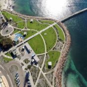

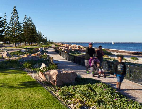
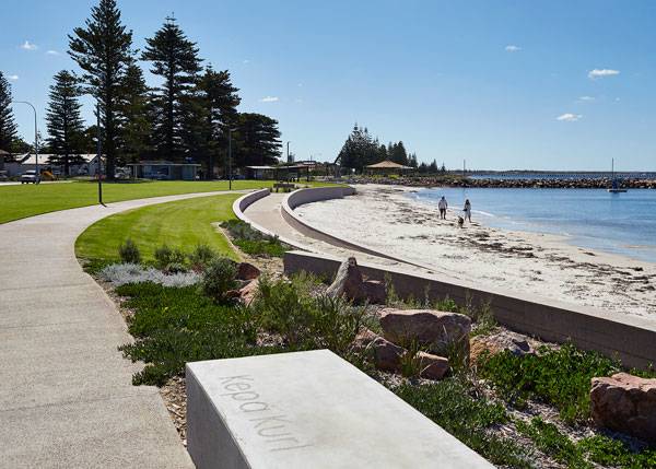
Esperance Waterfront | Drawing the Past to Future
By Niriti Porwal – A Review of Esperance Waterfront, by HASSELL, in Esperance, Australia. The town of Esperance — located 720 kilometers southeast of Perth in Western Australia — is experiencing a rapid urbanization, with the state’s population expected to more than double by 2050. Esperance Waterfront, a 1.1-kilometer-long site, was recently developed along the coast to meet the new infrastructural needs of the town. This project is an addition to the worldwide portfolio of landscape architecture that connects the landscape with the context for a sustainable urban environment. Designated as a “Super Town” by the government, Esperance is earmarked for strategic development to support the growth of its town. HASSELL was chosen as the principal consultant for this waterfront renewal project. The prime expectation was a development that would keep the essence of the city alive while accommodating the future development the town is expected to experience.
Esperance Waterfront. Photo credi: Peter Bennetts
The Design – Esperance Waterfront
Wedding the Past to the Future
The design for the project draws its concept from the history of Esperance. To implement it properly, HASSELL’S design team worked with the Shire to understand the relationship of the people with the waterfront and how they see the development in the future. The constructive conversations resulted in a few major interventions, including a reclaimed headland, a continuous revetment along the promenade, pavilions, and play space for family gatherings.
Esperance Waterfront. Photo credi: Peter Bennetts
Designs that Serve All
Programmatically rich, the design includes a plethora of activities that take into account people of all age groups and interests. Reorienting the park as a family destination was an important consideration, which has made the project lively. The entrance to the site is marked by a whale tail sculpture located at the beachside plaza at James Street. The intervention allows improved access to the waterfront and connects the site with the historic town. Following the plaza, the reclaimed land around the historic tanker jetty was planned to provide a vast area of 11,000 square meters for public events and sports.
Esperance Waterfront. Photo credi: Peter Bennetts
Esperance Waterfront. Photo credi: Peter Bennetts
Esperance Waterfront. Photo credi: Peter Bennetts
Creating a Sense of Belonging
What makes the project unique is the connection between the site and people. To create a sense of place, design decisions were made by involving historians, local artists, and graphic designers. When one walks through the site, it narrates stories about the indigenous, natural, and early settler history of the town. The experience is enhanced by nodal points along the pathways, integrated with artistic signage. Public art combined with distinctive flora and fauna at important places highlight significant elements such as Sammy, the adored resident seal.
Esperance Waterfront. Photo credi: Peter Bennetts
Foundation for the Future
The choice of plants for a landscape project is a crucial decision that brings inclusiveness in varied design elements. However, the specification and management of plantings, particularly ground cover and tree stock, becomes challenging in a coastline environment, explains Anthony Brookfield, principal at HASSELL.
Esperance Waterfront. Photo credi: Peter Bennetts
Esperance Waterfront. Photo credi: Peter Bennetts
A New Lifeline
Esperance Waterfront has become one of the most conscious design solutions speaking to context, accommodating the future needs of a growing population, and at the same time being ecologically sensitive. According to the Shire of Esperance’s 2015 waterfront community and tourist satisfaction survey, more than 85 percent of locals said the waterfront redevelopment met their expectations. Ninety percent of locals use the foreshore every week. Esperance Waterfront is truly a cultural and environmental restoration for a central foreshore community. What do you think? How can landscape projects remain true to their context and yet fulfill the needs for future development?
Esperance Waterfront. Photo credi: Peter Bennetts
Full Project Credits For Esperance Waterfront :
Project Name: Esperance Waterfront Location: Esperance, Australia Client: Shire of Esperance Landscape Architect: HASSELL Scale: 8 hectares Year: 2015 Status: Completed Project Consultants: JDSi Consulting (Civil Engineer), 3E Consulting Engineers (Lighting Design), Harriot Mair Landscape Architect (Local Landscape Architect), CADSult (Irrigation), Beverley Iles (Artsource), Paperbark Technologies (Arborist), Cartman Designs/HASSELL (Architect), Scott Smalley Partnership (Structural Engineer), Griffiths Architects (Heritage Consultant), Sime Building and Construction (Construction) Photography: Peter Bennetts Site Plan: HASSELL Awards: 2016 Australian Urban Design Awards – Commendation for Delivered Outcome – Large Scale 2016 Australian Institute of Landscape Architects (Western Australia) Awards – People’s Choice Award 2016 Australian Institute of Architects (Western Australia) Awards – State Commendation for Urban Design Recommended Reading:
- Becoming an Urban Planner: A Guide to Careers in Planning and Urban Design by Michael Baye
- Sustainable Urbanism: Urban Design With Nature by Douglas Farrs
- eBooks by Landscape Architects Network

Funmix Shopping Centre | Landscape Architecture Meets Retail in Beijing
Article by Win Phyo – Funmix Shopping Centre, by LSA Design, in Beijing, China. Shopping malls in Asia are not only a source of retail therapy but also a prime location for social hangouts. Modern China is no stranger to consumerism, and Beijing, the third-largest city in the country, has fallen prey to shopping mall developments. Towering over the city at more than three stories in height, these large-scale buildings were widely invested in by China’s urban planners to meet the growing demand and also to suggest the aspirations of the urbanizing middle class. But as often happens, too much of a good thing can be a bad thing: Many of these malls are on the verge of economic collapse, forcing developers to try harder in order to attract more people.
Funmix Shopping Centre. Credit: LSA Design
Funmix Shopping Centre
That’s where Funmix Shopping Centre comes in. The new mall focuses on cheerful and functional outdoor resting and play spaces. Like flies swarming to a source of light, children and adults alike are drawn to the bright outdoor features. Could malls such as Funmix be the answer to retailers’ prayers? “To see elements like our bubble seats and the F-U-N-M-I-X lightboxes built — elements with less conventional design details and construction methods, elements which are often labeled too hard after the concept stage in China and discarded — to see them built makes the push to get something unique for a project like this all the more worthwhile.” – Marc Deuschle
Funmix Shopping Centre. Credit: LSA Design
Letting Go of Passive Recreation
The core nature of the Funmix space is rooted in themes of action/activity and function. Around the building itself are a series of open, inviting, and bold pedestrian social-scapes (no vehicles clogging these areas) that don’t rely on people enjoying them passively. As such, there is color, movement, sound, and vegetation that won’t become stagnant as time goes by. At the street level, commercial plazas dot each of the three main entrances. The ground is dressed in a flowing wave pattern, which extends into the building’s ground floor.
Funmix Shopping Centre. Credit: LSA Design
Funmix Shopping Centre. Credit: LSA Design
Funmix Shopping Centre. Credit: LSA Design

Funmix Shopping Centre. Credit: LSA Design
Shopping “Centres” to Shopping “Spaces”
As online shopping gets more popular in China, there is a competitive need for physical shops and the spaces that encapsulate them to work harder both internally and externally. Therefore, designing them as an incorporation of public squares, plazas, and play-scapes could well be the answer: Shopping isn’t merely popping in and out of shops, but an exciting journey.
Funmix Shopping Centre. Credit: LSA Design
Funmix Shopping Centre. Credit: LSA Design
Funmix Shopping Centre. Credit: LSA Design
Full Project Credits For One Canal :
Project Name: Funmix Shopping Centre Client: Beijing Vanke Ltd / Cofco Date: Completed January 2015 Design Team: LSA Design – Marc Deuschle / Alex Zhang / Nicholas Pierson www.lsadesign.com.au Other Consultants: Woods Bagot / CPG Architects & Planners Local Landscape Design Institute: Miland Design Major Materials: Concrete and brick pavers, steel, poured softfall, perforated aluminium, fiberglass Length of Construction: 6 months (landscape only) Recommended Reading:
- Becoming an Urban Planner: A Guide to Careers in Planning and Urban Design by Michael Baye
- Sustainable Urbanism: Urban Design With Nature by Douglas Farrs
- eBooks by Landscape Architects Network

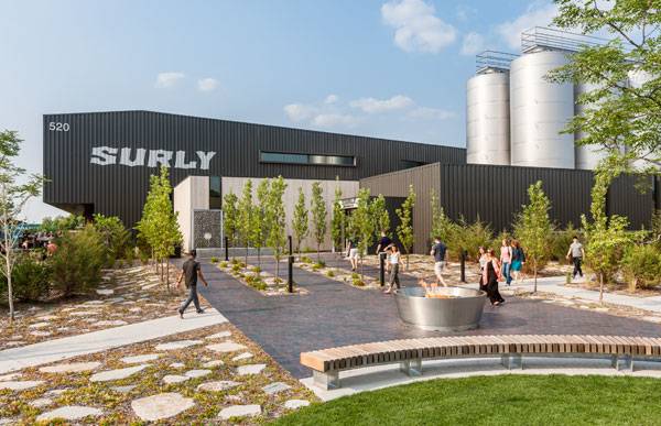
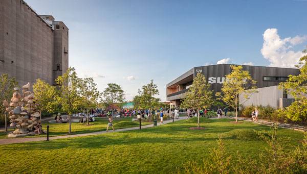
Surly Destination Brewery | 6 Reasons Why this Brewery is so Much More Than Just Beer
Article by Meenal Suresh – Surly Destination Brewery, by HGA, in Minneapolis, MN, USA In its most simple definition, a brewery is a place where beer is produced commercially. But can a brewery also be a unique and welcoming public gathering space? The Surly Brewery in Minneapolis shows that it can. This brewery isn’t just a space for crafting beer; it has also become a homeground for cultural activities, owing to its surprisingly festive environment in a working industrial space.
Surly Destination Brewery
The AIA Minnesota Honour Awards Jury commented: “This brash, industrial project’s exterior space really grabbed our attention – this project almost straddled the line into urban design. It focuses on catering to the future demands while making a mark in the present.” What makes this hot property a worthy visit for beer enthusiasts and tourists alike? Here, we decode how it became a brand in and of itself.
Surly Destination Brewery. Photo credit: Corey Gaffer
1. A Multivenue Concept
The Surly Brewing Company in nearby Brooklyn Center had reached its production limits and was struggling to meet the needs of consumers in 2011. The solution was a new brewery that not only met the local need, but also reached out to international tourists and beer enthusiasts. This facility was designed on the multivenue concept (similar to Stone Brewery in San Diego and Stiegel Brewery in Austria), in which consumers can observe the beer-making process and also enjoy the finished product on site. But first Surly had to overcome a major obstacle: state law prohibited breweries from making, selling, and serving beer all on the same site. Voices were raised, the law was amended, and the “Taproom Bill” or “Surly Bill” went into effect.
Surly Destination Brewery. Photo credit: Corey Gaffer
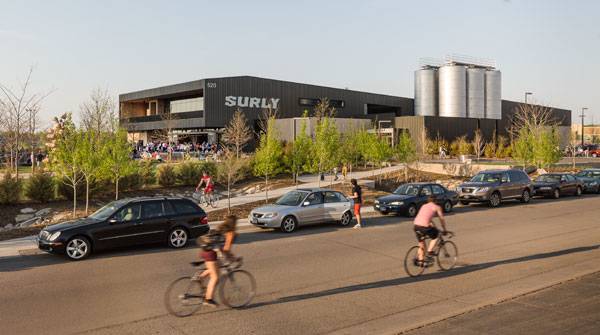
2. Premium Connectivity
The location of the new brewery played a pivotal role, playing up the site’s advantages while turning certain challenges into benefits. Situated near the University of Minnesota’s Twin Cities campus, Surly Brewery is connected to the rest of the city through an excellent transportation network of light rail transit and local highways, making supply, shipping, and visiting easy. It also draws water from Surly’s Brooklyn Center facility, ensuring that both branches provide same-tasting brews.
Surly Destination Brewery. Photo credit: Paul Crosby Photography
3. A Regenerative Greening Project – Toward a Sustainable Future
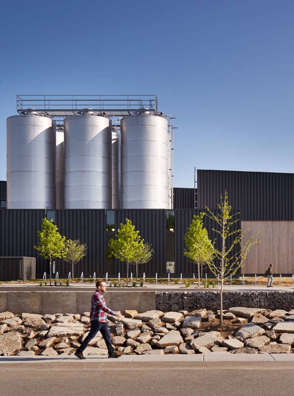
The 8.3-acre site is comprised of seven separate parcels of land, divided by the municipalities of Minneapolis and St. Paul, which meant many laws and jurisdictions had to be taken into consideration. It was also a brownfield site that previously housed many industries, the latest being a potato-processing plant. This meant the industrial park had to be replenished, especially since hazardous methane gas was escaping from the soil. A membrane floor and structural concrete slab with continuous ventilation were employed after all the drains were located, ensuring that all of the utilities were operated on ground and only the drains ran below.
Surly Destination Brewery. Photo credit: Paul Crosby Photography
Surly Destination Brewery. Photo credit: Paul Crosby Photography
Surly Destination Brewery. Photo credit: Paul Crosby Photography
Surly Destination Brewery. Photo credit: Corey Gaffer
5. Creative Recycling Provides the Edge
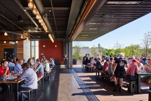
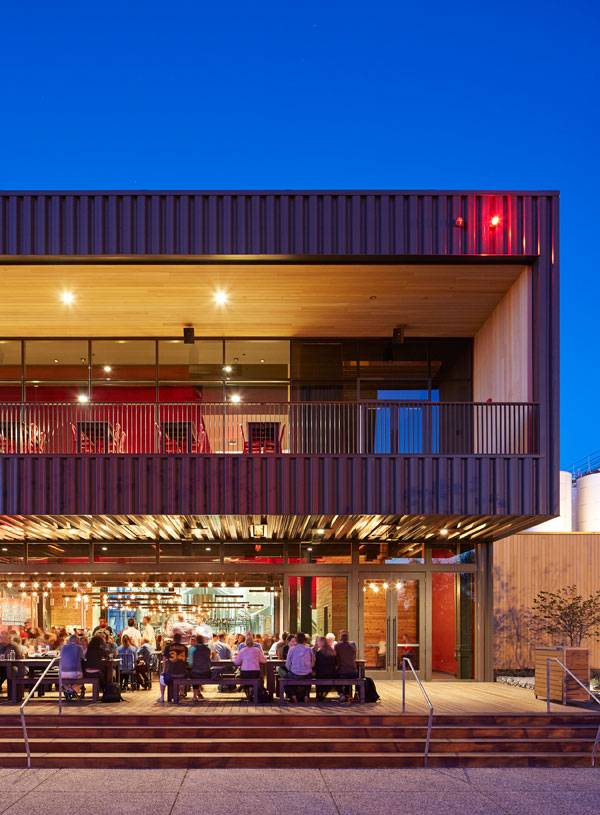
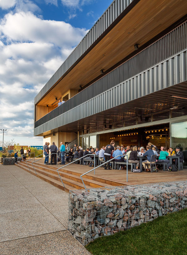
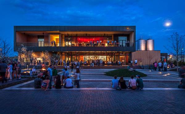
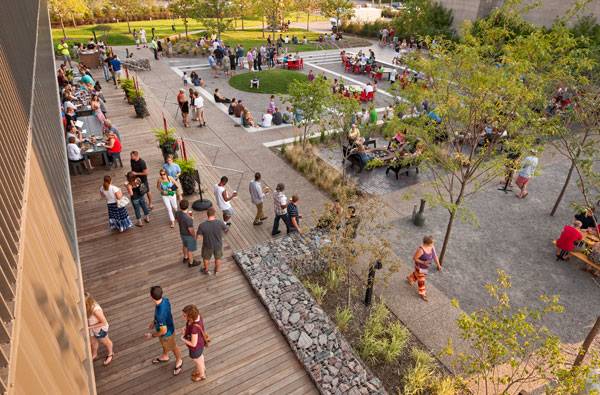
One then proceeds to the open beer hall, with the typical long, communal-style tables. Black metal and cedar are used throughout the beer hall. The hall is flanked by the brew house, the beer garden and deck, an amphitheater, and a free-flowing, 10-foot-high space. Overlooking the hall on the upper level is the formal Brewer’s Table Restaurant, with pre-function, events, and bar areas. An adjacent outdoor deck looks upon the gardens and interactive spaces.
Surly Destination Brewery. Photo credit: Paul Crosby Photography
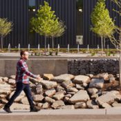
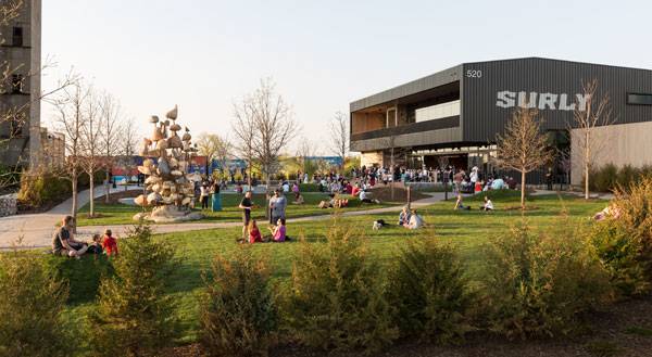
6. Landscape Employed to Create Elements of Surprise
The beer garden is surrounded by a series of gabion walls and a dense hedge of red cedars that can be segregated into three smaller pockets, providing visitors multiple choices to suit their mood. The Grove, as the name suggests, is a forest of honeylocust and serviceberry trees surrounding the flexible seating area of picnic tables and benches around a fire pit. It is reminiscent of a camping site. The crushed granite surface of the Greek-style terraced amphitheater looks over the stage and is backed by an artistic turf mound. Probably the most informal space on the site is the Spill Garden.
Surly Destination Brewery. Photo credit: Paul Crosby Photography
Surly Destination Brewery. Photo credit: Paul Crosby Photography
Full Project Credits For Surly Destination Brewery :
Project: Surly Destination Brewery Client: Surly Brewing Company Location: Minneapolis, MN, USA Architects: HGA Landscape Architect: HGA Design Principal: Steven Dwyer Engineer: HGA Principal in Charge: Mia Blanchett Project Architects: Robert Good, John Cook Project Manager: Johanna Harris Project Team: Alex Terzich, Jesse Zeien, Paula Storsteen, Jennifer McMaster, Rich Firkins, Tony Staeger, Mark Johnson, Scott Lichty, Julie Hagstrom, Ross Altheimer, Erica Christenson, Kenny Horns, Chrysanthi Stockwell, Zac Poynter, Joe Wetternach, Connor Frazier, Robert Johnson Miller Size: 50,000 square feet Cost: $16 million (construction) Start Date: October 2013 (construction) Completion Date: June 2015 Photographs: Paul Crosby Photography and Corey Gaffer Contractor: McGough Construction Recommended Reading:
- Becoming an Urban Planner: A Guide to Careers in Planning and Urban Design by Michael Baye
- Sustainable Urbanism: Urban Design With Nature by Douglas Farrs
- eBooks by Landscape Architects Network