Most landscape architects don’t use Revit, and it’s not surprising to see why. Right from the outset, even Autodesk’s description of Revit demonstrates the software’s inclination towards architects and buildings:
“Autodesk Revit software is specifically built for Building Information Modelling (BIM), helping building professionals to design, build and maintain higher-quality, more energy-efficient buildings.” (Autodesk 2014)
Although Autodesk appears to favor the architecture, engineering and construction (AEC) industry over landscape-specific capabilities, there are a number–my guess is that this is relatively small–of landscape architects that do successfully work with Revit. One of the major benefits of doing so is the ability to more closely collaborate with other professions of the AEC industry who also work with Revit.
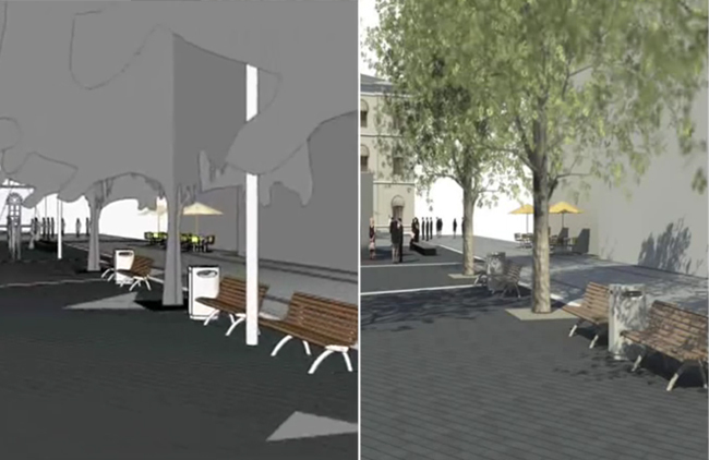
In addition to a more streamlined workflow, there are also additional ways that Revit can be applied to the work of a landscape architect. Most of these benefits are related to the modelling of exterior site design elements such as retaining walls, areas of paving, site fixtures such as fences, handrails, seating and so on. Associated with these parametric objects is a database of information that can be used for detailing, quantity take-offs, procurement, future maintenance requirements, etc. Plus, since the workflow of Revit is centred on the creation of a virtual 3D model of your design, amendments made to this design can be carried across multiple drawings (plans, sections, 3D views), which leads to greater work efficiency.
Modelling and rendering exterior site design elements such as areas of paving and site fixtures | Revit Landscape
For instance, Revit’s Toposurface tool allows for the creation of a 3D terrain model. A basic Toposurface is usually created by either placing spot levels yourself or by importing 3D terrain data from another drawing. Terrain information from Google Earth can be incorporated within your Revit model by importing the terrain into SketchUp and exporting this to .dwg.
A Landscape Architect’s Experience with Revit
I recently spoke with Lauren Schmidt, landscape architect, Revit user and BIM blogger, about how her experience with the program.
Jason Packenham (JP) – What type of landscape architecture work are you typically involved in?
Lauren Schmidt (LS) – As a part of an architecture/engineering firm, most of the projects I work on are sites that are focused around a building. Those projects range from K-12 schools, higher education, corporate offices, to urban infill development. We also work on more traditional landscape architecture work, such as parks, trails, and master plans.
JP – Given the hesitance by many landscape architects to make the switch to Revit, what influenced your decision to do so?
LS – Well, it was actually an idea that originated from architecture. They have been working in Revit for about 6 years – all of the other building-oriented disciplines; interiors, mechanical, electrical, and plumbing, work entirely in Revit. Only our civil engineers and landscape architects still work in AutoCAD.
The tipping point happened 2 years ago. Most of our office was working on a large, complex high school project. We found that the landscape was being drawn repeatedly and in too many places; plans in AutoCAD, 3D model in SketchUp, sections drafted in AutoCAD, and yet a Revit model was still created so the other disciplines could visualize and coordinate with the landscape. Consolidating all of that into Revit just made sense.
JP – With Revit being oriented predominantly towards architects, what ‘landscape’ and BIM features does the program offer? And how do you use these features within your projects?
LS – I will be the first to admit that Revit is not perfect for creating landscapes. What is often the most useful are the standard BIM features, like the ability to schedule and tag “smart” objects; planting schedules, plan notes, and cost estimates require almost no effort. But the simplest and best feature is having an accurate 3D model that is also driving your construction documents.
JP – How has adopting Revit influenced how you collaborate with other architecture, engineering and construction industry professionals?
LS – With the landscape in Revit, collaboration with architecture and engineering is on an entirely different level. I have their ‘live’ model linked directly into the landscape model and vice versa – and as these projects move into construction, contractors are asking for these BIM models for cost estimating, clash detection, and construction sequencing. Eventually, BIM will be industry standard, because anything less won’t be worth it.
(Related Article: BIM in Landscape Architecture)
Scheduling in Revit | Lauren Schmidt
Can Revit Boost Interdisciplinary Collaboration?
For a better idea of how Revit can aid collaboration with other AEC industry professionals, I also spoke with Lachlan Stanton, Architect at Drum Rose Architects, based in Sydney, Australia. I asked him about the advantages of collaborating with landscape architects using Revit instead of 2D CAD alternatives.
“I guess one of the biggest factors is the ability to collaborate in 3D. Revit’s ‘Central Model’ allows for multiple people to work on different elements of the model whilst compiling all the information into one central model. This means that a landscape architect could model exterior design elements such as topography and vegetation while the architect sticks to the building. As the project progresses, the Central Model would build into a complete model. This would save the need to have multiple drawings, and to be constantly sending updated plans back and forth.
Revit also has the power to implement sun paths and see what shadows trees and other vegetation cast. It can also be used to show how much light these plants have access to and show how the landscape will change over time. This means the landscape architects modelling can directly influence the work we do as architects, and have a greater impact on project outcomes.”
With this being said, standalone Revit doesn’t offer a landscape architect the same site-design and landscape capabilities that other programs do. However, Eagle Point’s add-on programs Siteworks and LANDCADD can increase the landscape-specific functionality of Revit.
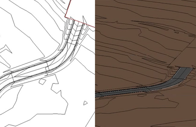
Grading tools in 2D and 3D | Eagle Point
Using Eagle Point’s Products to Increase Functionality
Eagle Point’s products offer landscape architects the ability to shape terrain using grading tools to model pads, parking lots, streets, sidewalks and retaining walls. LANDCADD also enables the locating of trees, shrubs and groundcovers into the model, which are associated with a large database of searchable plants. You are also able to lay out other landscaping features, such as paths, plazas or parking areas and obtain areas or take-off materials.
3D visualisations seem a little scant on landscape details | Eagle Point
Pushback Against Revit in Landscape Architecture — Is it Worth the Investment?
The popular landscape-specific add-on for AutoCAD, Land F/X, does not work with Revit. I recently caught up with Jeremiah Farmer, CEO and Developer of Land F/X to ask why. He explained: “Revit is a non-starter for Landscape Architecture – it is wholly unsuited for site and landscape work. We have heard nothing but horror stories of clients being forced to use it. Revit has a simple and clear path to export the building to SketchUp. So from our perspective, that of the Landscape Architect, SketchUp is the better 3D collaboration venue, where all disciplines can easily come together.”
A part of me gets the feeling that the presence of Revit within a small portion of the landscape architecture profession is probably due to the pressure for landscape architects to collaborate with architects and other professionals already using the program. This then raises an important point for landscape architecture firms where collaboration with other professionals using Revit isn’t a priority.
Revit wasn’t really made for us landscape architects, and despite anecdotal evidence of its success for some, it’s hard to recommend it. Although there are additional add-on programs available for Revit that are oriented towards landscape architects, I think we are still a fair way off Revit offering a comprehensive option for a landscape architecture firm to justify the cash and time investment.
A big thank you to Lauren Schmidt and Lachlan Stanton for their input to this article! This article is part of the Digitising Landscape Architecture series. Click here to view other articles in the series.
Jason Packenham is a Landscape Architect at Corkery Consulting and design studio tutor in the Bachelor of Landscape Architecture program at the University of New South Wales.
Published in Blog












Chris D
Bizarre of Jeremiah Farmer to claim that Revit “is wholly unsuited for site and landscape work” when lots of people are doing exactly that. It just needs a decent plug-in like Land F/X to make it easier…. Laughable if he thinks we’re going to use Sketchup to do it.
Jason Packenham
Chris – sorry for the delay in my response, I had been hoping for Jeremiah to respond directly to your comments regarding Land F/X.
I agree that some people are using Revit for site and landscape work, and that a decent plug-in like Land F/X would go along way for landscape architects looking at the software.
It is a big time and monetary investment though, and for those firms not focused on collaboration with other professionals using this software, its hard to look past other software options that come with a price tag a little easier to digest.
Chris D
Absolutely it’s about those landscape architects in multi-disciplinary practices (like ours) , and those who wish to be part of a design team using BIM. Neither AutoCAD nor Sketchup is BIM software.
Walter Bone, RLA
Very informative, thanks Jason and Lauren, well done.
UfukBektasoğlu
Hi,
http://architecturalrenderingoffice.com/blog/
I think this will helped you for 3d softwares different, article name is:
12 Best Software in 3D Architectural Rendering