


Author: Land8: Landscape Architects Network


What are the Benefits of Natural Play?
The concept of natural play has been steadily gaining popularity in recent years and is now one of the main “buzz words” bandied around by architects, planners, and developers. But what are the main principles of natural play, why is it considered better than conventional play equipment, and what role does landscape architecture have to play in the creation of natural play areas?
What is natural play?
Natural play refers to interacting with natural elements of the environment in an imaginative way. Broadly, natural play includes activities such as climbing trees, building dens, and cooking outdoors. Today, children are becoming ever more environmentally insular, often spending many hours a day in front of televisions and computer monitors. The natural play movement aims to encourage children to get out into the natural or semi-natural environment. WATCH: What are Natural Play Spaces?
Where does natural play take place?
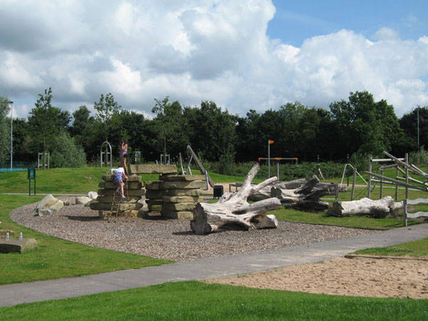
Natural play can take place anywhere where children have access to natural elements. Sadly, in many towns and cities, access to the natural environment is either limited or absent. Therefore, landscape architects are increasingly asked to develop local play areas with natural play elements. These natural playgrounds mimic the natural environment, offering a non-prescriptive and imaginative play resource.

Autumn- CC0- Natural Play
Natural play benefits
Prescribed play (i.e. manufactured play equipment) often has a limited number of ways it can be used. It is believed that encouraging children to simply climb the steps and slide down the slide limits their creative ability. Natural play, in contrast, encourages children to think about how to climb a tree or traverse obstacles such as boulders or fallen trees. Related Articles:
- Exceptional Ecological Park Reconnects Children With Nature
- Ecological Landscape Design, Embraces Massive Body of Water
- Giant Sized Pergola Creates Ecological Haven
As natural play has no prescribed minimum and maximum dimensions for elements, children engage a greater range of muscles when playing, stretching both their bodies and imaginations. It has even been demonstrated that children with ADHD show better concentration after interacting with the natural environment. “Research indicates that unstructured play in nature increases self-esteem, creativity, motor skills, fitness, and even academic performance. It also seems to relieve symptoms of ADHD.” – Richard Louv, Last Child in the Woods

Girl in Woods CC0 – Natural Play

Person CC0 – Natural Play
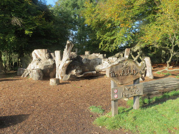
The Wildwood Den Natural Play Area at Ashridge, UK, CC2
Alt Park by Sue Adair-CC2.0 – Natural Play
- Design with Nature by Ian L. McHarg
- Sustainable Urbanism: Urban Design With Nature by Douglas Farr
Feature image: Children CC0. Article by Ashley Penn Return to Homepage


Everything You Need to Know About Landscape Lighting Using Solar Power
Thinking of using solar power for landscape lighting – Read this article first. The only thing better than having a beautiful garden is enjoying your home’s landscaping even after the sun goes down. With solar powered outdoor lighting, you can showcase your gorgeous gardens and landscaping at night without running up your power bill. With sun-powered greenery in mind, here are just a few benefits of using solar power to light your landscaping.
Landscape Lighting Using Solar Power
How Solar Landscape Lighting Works Although it may sound strange that something powered by the sun would have a use at night, solar powered landscape lighting is actually quite effective. Just like rooftop solar panels collect the sun’s energy during the day, so do landscape solar panels. The main difference is that landscape solar panels use batteries and come in many different sizes and styles.

Solar Power. Image credit: Via Flickr by OregonDOT, Licensed under CC 2.0
- Three Things to Consider When Purchasing a Garden Shed
- Lighting Solutions – World’s tiniest recessed LED luminaire – 1PUCK LP by MINIMIS
- Artistic Fire Pits For Long Summer Nights
Low-voltage landscape lighting systems are another popular type of landscape lighting. These systems are usually powered through a larger solar panel and are capable of lighting tall trees and shrubbery. Because low-voltage systems use a central transformer, they require wires, which makes the installment process a little inconvenient. However, low-voltage systems shine brighter and longer than solar powered path lights. Path Light and Panel Placement When choosing locations for your path lights, you won’t have many options because you’ll want to stay close to the walkway or path you’re lighting. With that said, you’ll want to pay attention to the sun’s location during the day. Tilting and angling the path light toward the midday sun will improve the charging process. Low-voltage solar systems use more power than that of wireless path lights. Because of this, you may consider a new solar power system that can light up your home and garden as well as the rest of your landscaping. These solar systems use full-sized rooftop panels, which require professional installation and wiring to your home’s main breaker box. Care and Maintenance Another benefit of solar landscape lighting is that the equipment is generally maintenance-free. For path lights and rooftop panels, keeping the solar panel surface clean will improve the system’s charging capabilities. This means wiping the surface with a wet rag or spraying down the panels with a hose at least once a month. As mentioned before, solar path lights use rechargeable batteries that need replacement within two years. If your LED bulbs aren’t shining as bright, this is usually a sign you need to clean the solar panel or replace the battery. Solar Landscape Lighting Tips If you choose solar path lighting to illuminate your garden and landscaping at night, you’ll want to trim shrubs or foliage around your path lights so the solar panels get optimum sun exposure. This may require changing the location of the path lights once or twice a year. Likewise, make sure your path lights aren’t exposed to any street lamps or other light sources at night. Most solar path lights use light sensors that conserve energy by keeping the LED bulbs off until it’s completely dark. If there is light from a nearby streetlamp, the bulbs may not shine as bright, or worse, they may not come on at all. When you’re ready to light your home’s landscaping and gardens at night, keep in mind the features and benefits of solar powered landscape lighting. Return to Homepage Featured image: View of the solar panels. Credit: Oregon Department of Transportation, source, licensed under CC 2.0

How Vinterbad Brygge Winter Baths Became a National Sensation
Vinterbad Brygge, by BIG in Copenhagen, Denmark. People in Scandinavian countries have a very special perception regarding physical contact with water. The most common ritual is known as the “Nordic Bath” and it originates from Finland. The ritual of a “Nordic Bath” involves alternately taking a dip in cold then hot water. It is an activity that has social, health, and cultural aspects well founded in Scandinavians’ perception of life. The use of thermal baths goes a long way back in the history of these countries, as well as in other countries worldwide. Winter swimming seems to also be a very popular activity in Northern Europe, although the climate would suggest otherwise.

Vinterbad Brygge. Photo credit: BIG – Bjarke Ingels Group
Vinterbad Brygge
The Harbour Baths in the island Brygge in Copenhagen, Denmark, are a landmark for both the citizens of Copenhagen and the city’s visitors. The indisputable success of the baths, after their inauguration in 2002, has led to the extension of the facilities in order to accommodate thermal bathing. The Thermal Baths design has been assigned to the architectural office BIG. BIG, in collaboration with the architectural firm JDS, also designed the existing swimming facilities.

Vinterbad Brygge. Photo credit: BIG – Bjarke Ingels Group

Vinterbad Brygge. Photo credit: BIG – Bjarke Ingels Group
- Unbelievable Conceptual Pool Design That Plays With Your Mind
- The Floating Pool – A Revolution in Public Space
- Rooftop Infinity Pool with Awesome Views
The entrance toward the Thermal Baths has been perceived as a linear crack on the wooden surface. The design intention is to intensify the transcendence from the exterior to the interior and becomes a prelude of the bath ritual. The spatial atmosphere resembles the spirituality of a temple entrance. The interior of the baths is divided by mirrored walls, giving a sense of a spatial infinity by blurring the boundaries between the different rooms.

Vinterbad Brygge. Photo credit: BIG – Bjarke Ingels Group

Vinterbad Brygge. Photo credit: BIG – Bjarke Ingels Group

Vinterbad Brygge. Photo credit: BIG – Bjarke Ingels Group

Vinterbad Brygge. Photo credit: BIG – Bjarke Ingels Group
- Urban Design by Alex Krieger
- Digital Drawing for Landscape Architecture by Bradley Cantrell
Article by Eleni Tsirintani Return to Homepage


The Mysterious Castle of Sir Edward James and the Xilitla Garden
We take a moment to explore the delights of the exotic Xilitla garden. Inspired by great architects and artists such as Antoni Gaudí, Giovanni Baptista Piranesi, and Maurits Cornelis Escher and his surrealist friends Salvador Dalí, Leonora Carrington, and René Magritte, Sir Edward James found in Mexico, in the middle of the jungle, an opportunity to build a living dream — nearly 80 acres of paradise waiting to become a surreal garden. The construction took almost 40 years (until James passed away), and yet remains unfinished. A new visitor can’t tell what the purpose of the edification was: stairs leading to nowhere, infinite paths, arches, and sculptures all around. WATCH: An Incredible Overview of the Xilitla Garden
Xilitla Garden
The Castle of Edward James has become a landmark and one of the top travel destinations in the region. It is a place hard to imagine and impossible to understand. Sir Edward James, the man, the legend More than 100 years ago, a man was born in Scotland with the name of Edward Frank Willis James. He was raised in a privileged family and was very well educated in the arts since his childhood. As a young man, James inherited a fortune from his father and uncle. Looking forward to being part of the surrealist movement, he left college and moved to mainland Europe, becoming a close friend of some interesting personalities, including Salvador Dali and Pablo Picasso, among many others.

Xilitla Garden. Photo credit: Andres Guevara

Xilitla Garden. Photo credit: Rod Waddington

Xilitla Garden. Photo credit: Andres Guevara

Xilitla Garden. Photo credit: Don Walheim

Xilitla Garden. Photo credit: Rod Waddington

Xilitla Garden. Photo credit: Don Walheim
- The Alchemy Garden: A Secret Look into the Monsters Park of Bomarzo
- The Lost Gardens of Heligan
- The Flying Parks- From The Highline in New York to The Promenade Plantée in Paris!
A river runs through the property and along a beautiful waterfall, harnessed to create multiple “pools” near corresponding sculptures.

Xilitla Garden. Photo credit: Lucy Nieto
Surrealism at Xilitla Garden
Walking along, the garden sculptures pop up randomly. They all represent something (most of the time something religious), but there is no hidden message or interconnection between these symbols. Probably, the only reason for this symbolism is to justify its presence in some way: stairs going nowhere, giant concrete columns and flowers.

Xilitla Garden. Photo credit: Rod Waddington

Xilitla Garden. Photo credit: Lucy Nieto
- Private Gardens: Personal Gardens of Ancient China by Cheng Liyao
- Earthly Paradises: Ancient Gardens in History and Archaeology by Maureen Carroll
Article by Eduardo Reguer Return to Homepage


MultiSit: The 3-in-1 Design Solution for Public Seating
MultiSit is a design solution aiming to change how we observe and engage with our urban environment. We all know that our world never stops changing. Inevitably, the same goes for us: people. We change the way we live, our environment, our technologies, our surroundings. And through this constant development, our needs alter, as well. To satisfy our needs, design is also changing on a daily basis. A good example of this kind of transformation can be found in the comparison between a conventional, standard park bench and an up-to-date, cutting-edge design of a public seat.

Image courtesy of MultiSit
MultiSit – Sit, Fence, Advertize
“MultiSit is an elegant, clean looking and durable seat serving three functions in one – sitting, fencing and advertising,” this is how Christof Niederberger, CEO of Tri-On Gmbh in Austria, describes the characteristics of the product. MultiSit is a suitable choice for expedient sitting arrangements in public or business areas due to its elegant design, safe use, and zero maintenance.

Image courtesy of MultiSit
- How to Make an Unnatural Space Feel Like a Natural Park
- Turenscape Design Outstanding River Park
- Shipyard Site Transforms into Stunning Ecological Park

Rotary joints. Image courtesy of MultiSit

Image courtesy of MultiSit
MultiSit in the Future
Having discussed the product in detail, let’s examine how the ideas about the brand are expanding. The brand of MultiSit is planned as a product line, which has an expandable modular system. Besides MultiSit, there is one more available product, the MultiSit bicycle stand. Supplementary products, such as the MultiSit waste container and the MultiSit work table, are currently in a development stage.

Image courtesy of MultiSit
- Urban Design by Alex Krieger
- The Urban Design Handbook: Techniques and Working Methods (Second Edition) by Urban Design Associates
Article by Velislava Valcheva Return to Homepage


Top 10 YouTube Tutorials for Technical Drawing
YouTube can deliver many great tutorials on the subject of technical drawing, so feel free to check out this Top 10 and form your own opinion. Landscape architects are required to be familiar with technical drawing because so much of their work is related to space geometry and planning. The success of a landscape architect is often defined by how well his/her skills are developed, with technical drawing standing at the top of the list. Regardless of how familiar you are with technical drawing, there are still many things to be learned. The YouTube tutorials presented in this article are going to reveal essential information related to the field of technical drawing. It is well known that tutorial videos deliver the information faster and in a more efficient manner than other sources, so be sure to consider them as your source of knowledge. – Below, you will find the Top 10 YouTube tutorials for technical drawing. Each of them has something to offer in terms of knowledge and practical information, so be sure to pay attention to all and use them to develop yourself and your skills.
Tutorials for Technical Drawing
10. How to Make a Scale Drawing, by Dana Lee This video will take you back to the basics, teaching you all about the different measurement systems and types of technical drawing. The information is presented in easy-to-comprehend terms that explain the clear difference between one-to-one drawing (drawn object has the same size as in real life) and scale drawing (miniature sketches). I recommend this video, as it delivers essential information on scale and also highlights the importance of making a rough sketch before doing the actual drawing. Watch:
9. Introduction to Engineering Drawing, by EzEd Channel If you are looking for an introductory tutorial to the world of technical drawing, then this one is perfect for you. Thanks to this tutorial, you will learn what engineering drawing is all about, which drawing instruments are essential for this kind of work (along with individual uses), and the types of lines commonly chosen for technical drawing projects. I recommend this video, as it appeals to the visual sense (through graphic information) while delivering useful information through the spoken word. Watch:
8. Multiview Drawing, by Eric Fischer Multi-view drawing is one of the most important skills you will want to develop. This video tutorial made is great, as it takes you through all the steps of the process, teaching you how to transform a real 3D shape into a 2D drawing. The spoken information is strengthened by graphic information and written text. Watch:
7. How to Draw Oblique Sketches, by Ty Vernon The oblique tutorial is going to guide you through every step of the process, helping you learn how to draw oblique sketches. The information is structured into four parts, each being presented in detail. I recommend this video because it contains a wealth of useful information, delivered gradually so that you do not feel overwhelmed. Watch:
6. Understanding First and Third Angle Projections, by DesignInnovations If you are just starting to discover technical drawing, then you will need to watch this video. Presented in easy-to-comprehend terms, it will help you in understanding first and third angle projections. I recommend this video because it explains the differences between these two types of projections quite clearly. Watch:
5. How to Draw a City Using Two Point Perspective, by Circle Line Art School The two-point perspective is quite complex, and you need to learn it from the best. This video contains a simple demonstration on how a city can be drawn using this perspective, and the steps are easy to follow. I recommend this video because of all the knowledge it delivers. Watch:
4. Orthographic Projection Drawing Tutorial, by AutoCAD Tutorials For those of you who are interested in learning how to make a simple orthographic projection, there is no better tutorial to follow. It will present clear steps to take for drawing the front and end elevation, plus the plan for looking down on the object. You will find recommendations on what kind of pencil to use and how to measure correctly. Plus, it explains important things, such as the appearance of construction lines. Related Articles:
- Is Drawing Dead?
- How to Suck at Hand Drawings and Still be a Good Landscape Architect
- Interested But Not Confident? – Know How to be Good at Hand Drawings
Watch:
3. Orthographic Projection and Solved Question, by Khabia Sir This video is definitely worth seeing, as it explains the basic concepts behind orthographic projection. In providing this explanation, the author of the video makes use of a 3D model. I recommend this video because of the animated projections. Watch:
2. Using Sketching Effectively in Design – Drawing, Sketching and Designing, by The Open University This video tutorial is quite interesting, as it takes a simple toy and transforms it into an amazing sketch. There is a lot of visual information, including when it comes to the purpose of shading. Watch:
1. Rules for Dimensioning, by Jon Olson I have chosen this video for number one, as I feel it presents vital information for anyone who is interested in technical drawing. It offers a clear and simple perspective regarding the proper dimensioning techniques and is definitely worth watching. Watch:
Selecting Tutorials for Technical Drawing
In conclusion, you can find hundreds of YouTube tutorials that are meant to help you with your technical drawing skills. The important thing is that you learn how to select those that transmit meaningful information. Remember, selection is the key! Recommended Reading:
- Drawing and Designing with Confidence: A Step-by-Step Guide by Mike W. Lin
- Landscape Perspective Drawing by Nicholas T. Dines
Article by Alexandra Antipi. Return to Homepage


How The Fish Market Plaza Revamped This Forgotten Site
Fish Market Plaza by Thorbjörn Andersson & Sweco Architects in Karlskrona, Sweden. Does a spatial quality create a place or does it happen the other way around? Perhaps it works both ways. In the case of Fish Market Square, or “Fiskertorget Plaza” in Swedish, the place still exists under the same name, but everything else related to the market function is long gone. The Fish Market Plaza is located in Karlskrona, Sweden. Karlskrona, which means Carolu’s Crown, has always been an important harbor. Nowadays, it is also one of the most picturesque cities in Sweden and is protected as a World UNESCO Heritage Site.

Fish Market Plaza plan by Thorbjörn Andersson & Sweco Architects
The Fish Market Plaza
There used to be a Market Hall for selling fish where the square is now, but it was torn down in the 1960s. The only thing left after the demolition was the name of the site and a gap of potential waiting to be shaped. In 2009, a new intervention started to take shape, designed by Thorbjörn Andersson & Sweco Architects. The main purpose of the design has been to reconnect the city with the water’s edge and create a new spot for meeting and leisure.

Sketch of the Fish Market Plaza. Image courtesy of Thorbjörn Andersson & Sweco Architects

Sketch of the Fish Market Plaza. Image courtesy of Thorbjörn Andersson & Sweco Architects

The Fish Market Plaza. Image courtesy of Thorbjörn Andersson & Sweco Architects

The Fish Market Plaza. Image courtesy of Thorbjörn Andersson & Sweco Architects

The Fish Market Plaza. Image courtesy of Thorbjörn Andersson & Sweco Architects

The Fish Market Plaza. Image courtesy of Thorbjörn Andersson & Sweco Architects
- 5 Incredible Displays of Landscape Architecture in Switzerland
- Discover the Ancient Secrets of the Physic Garden

The Fish Market Plaza. Image courtesy of Thorbjörn Andersson & Sweco Architects
The Fish Market Plaza – 60 Years in the Making
What is astonishing about the Fish Square Market is that although the Market Hall was demolished almost 60 years ago, it took this long for the city to redefine the space’s identity. It could have been due to financial and other reasons. However, I could not help but think that the Fish Market has been more than a hall for the city’s perception of this particular place.

The Fish Market Plaza. Image courtesy of Thorbjörn Andersson & Sweco Architects
- Urban Design by Alex Krieger
- The Urban Design Handbook: Techniques and Working Methods (Second Edition) by Urban Design Associates
Article by Eleni Tsirintani Return to Homepage


How Zameret Park Gave Birth to a Distinguished Green Avenue in Tel Aviv
Zameret Park, by TeMA Urban Landscape Design in Tel Aviv, Israel. Perhaps the first thing to capture your attention from our headline was the unfamiliar word Zameret. That Hebrew word, often used as a girl’s name, literally means tree top. If you are wondering about the relationship between the origin of the word Zameret and the park, you are about to read the riddle within the framework of this project. To tickle your fancy even more, here is the philosophy behind the park, revealed on the website of TeMA Urban Landscape Design: “We develop our projects with an underlying theme. The theme runs like a thread between various parts and layers of each project, thus enabling its comprehension beyond the aesthetic experience. The theme serves the different planning phases, allowing for a fruitful dialogue to take place within the design team, as well as with the client.”

Zameret Park. Image courtesy of TeMA Urban Landscape Design
Zameret Park
That underlying theme has given character and distinction to Zameret Park, the landscape jewel of the Zameret neighborhood in Tel Aviv, Israel. The prime design concept covers the understanding that the newly built environment of the neighborhood should be strengthened and enriched. And naturally, the best possible way to achieve that effect is through excellently designed landscape architecture.

Zameret Park. Image courtesy of TeMA Urban Landscape Design
- Kiryat Sefer Park, Tel Aviv, Israel by Ram Eisenberg
- Elegant Square Sets the Stage for University Students
- How Did Tel Aviv Port Become the Best Design in Europe? Find Out
The luxurious buildings in the Zameret neighborhood consist of 14 skyscrapers, a small shopping mall with an adjacent office tower, and a future school. In order to design landscaping highlighting the luxurious nature of the architecture, TeMA created an elegant, exquisite solution, which beyond all question has fulfilled that aim.
The “Green River” Concept of Zameret Park
The graceful landscape design relies on a linear landscape core, planted with a diversity of native trees that cast shade on stylized grass mountains. Thus, a “green river” is formed, which mainly serves as a connection to both the pedestrian and underground parking entrances to each of the 14 high-rise buildings.

The masterplan of Zameret Park. Image courtesy of TeMA Urban Landscape Design

Zameret Park. Image courtesy of TeMA Urban Landscape Design

Zameret Park. Image courtesy of TeMA Urban Landscape Design

Zameret Park. Image courtesy of TeMA Urban Landscape Design

Zameret Park. Image courtesy of TeMA Urban Landscape Design

Zameret Park. Image courtesy of TeMA Urban Landscape Design
- Design with Nature by Ian L. McHarg
- Meadows by Design: Creating a Natural Alternative to the Traditional Lawn by John Greenlee
Article by Velislava Valcheva Return to Homepage

How The Canberra National Arboretum is Preventing a Disaster
The Canberra National Arboretum, by TCL, Canberra, Australia. The loss of habitats and the extinction of species are prevalent topics among environmentalists today. We are witnessing the largest extinction crisis since we lost the dinosaurs. According to the World Wildlife Fund, at least 10,000 species disappear every year — forever. At the same time, awareness of the amazing diversity and the imminent danger of its loss are probably higher than ever. Multiple organizations and even whole countries are working against the threat of extinction and habitat loss. Australia is one such notable example.
Canberra National Arboretum
In January 2003, a wave of fires wreaked havoc on the Australian mainland and its unique forests. Saddened by the loss, the ACT Government decided to act instead of grieving: It developed a proposal for an International Arboretum, to be established on a 250-hectare site six kilometers from the center of Canberra, at the western side of Lake Burley Griffin, an area offering unique, panoramic views over the capital. WATCH: National Arboretum Canberra: World Landscape of the Year 2014
The site included four existing forests, which were included in the final master plan: Quercus suber, planted between 1917 and 1920, which became Forest 1; Cedrus deodara, planted between 1917 and 1930 and again in September 2010, at present Forest 11; Pinus radiate, currently Forest 76; and finally other native trees and plantings, which now make up Forest 2. In 2004, an international design competition was held and in 2005, the winner was announced — the Australian landscape architecture practice Taylor Cullity Lethlean (TCL) in cooperation with Tonkin Zulaikha Greer’s (TZG), for their “100 Forests/100 Gardens” concept. The Design The original vision has its roots in the plans and dreams of Walter Burley Griffin and Marion Mahony Griffin, who 100 years ago drew the first plans for an arboretum that would include iconic trees from all over the world.

All of the 100 forests are arranged differently, the qualities provide distinct spatial arrangements that respond to species horticultural requirements and many cultural themes. Photo credit: Ben Wrigley
- The Australian Garden That Everyone’s Talking About!
- Top 10 World Class Landscape Architecture Projects of 2013
- Top 10 World Class Landscape Architecture Projects of 2014
The design’s orthogonal grid is superimposed bravely over the rolling hills of the impressive landscape. The sculptured earth terraces are filled with trees grouped into 100 single-species forests intertwined with 100 gardens. The Layout of the Forests Each forest consists of 200 to 3,000 trees and covers two to three hectares. The design’s form is simple and geometrical, with terraces linked by a cascading stream and a fully accessible pathway. It is supposed to not interfere with the natural landform nor with the planting. The individual forests are planted in a grid, arranged across the landscape to align with a civic axis created by the Burley-Griffins.

The Arboretum is host to a series of large sculptures that will, over time, be discovered within the forest landscape. Photo credit: John Gollings

The layout of trees are distinct for each forest and are designed based on their botanical or cultural qualities for each species. Each TCL designer provided ideas for the 100 forests, with the result of a patchwork of ideas. Photo credit: John Gollings

The sculptured landforms of the Central Clearing form part of the visitor arrival sequence. Photo credit: John Gollings

Cork Plantation that survived the 2003 Canberrra Fires. This existing plantation provided an insight into the potential of the immersive 100 forest concept. Credit: John Gollings

The Pod Playground consists of a toddler play area (banksias), swing set area, older children (acorn area) and net play to the left of the Acorns. The Acorn area consists of six Acorn cubby houses varying in height from 2.5 metres to 5 metres above ground. Photo credit: Brett Boardman

Rope tunnels connect four of the Acorns together, creating an clambering play element for children to explore the Acorns. The enclosed rope tunnels also allow heights to exceed 2.5 metres from the ground. Photo credit: Gemma Fennell
The Development of the Canberra National Arboretum
The first trees were planted in 2006, and the arboretum was opened to the public on Feb. 2, 2013, as a centerpiece of Canberra’s centenary celebrations. All of its 100 forests were already planted with trees such as Washingtonia filifera, Liriodendron chinense, and Wollemia nobilis. However, it is not nearly completed — the National Arboretum is meant to continue to develop and grow over time. Its potential and possibilities are unlimited.

Large terraced earth sculptures form the major arrival sequence into the Arboretum. At the base, a carefully designed irrigation system directs water to the dam to redistribute back into the Arboretum. Photo credit: John Gollings
- Urban Design by Alex Krieger
- Digital Drawing for Landscape Architecture by Bradley Cantrell
Article by Marta Ratajszczak Return to Homepage


10 Top Examples of Land Art From Around the World
We search for 10 top examples of land art from around the world. I have written previously about how public art is an essential ingredient in creating a city’s built environment in my article “Incredible Public Art at Highway Underpass!“. The powerful visions of artists often bring cultures and societies into deeper dialogue, ultimately creating more meaningful relationships between people and place — a goal central to the landscape architectural project. Hence, there is much to learn from artistry laid upon the land. Here are 10 examples of incredible land art:
Land Art
10. Chevron Cubes Located in Middlesbrough, England, Chevron Cubes is a piece of urban furniture created by design agency United Creatives as part of a Grant Associates mixed-use development public realm design. The florid colors reference the distinct locale of the project and endeavour to reflect the surrounding industry and residences.
Chevron Cubes. Photo credit: United Creatives Ltd.

Freedom. Credit: Zenos
7. Huellas Artes This architectural intervention by 100architects artistically recognizes and highlights the daily flux of human functions and flows around the Bellas Artes metro station in Santiago, Chile. It aims to revitalize and catalyze the site as a place for urban activity and the development of social relationships. WATCH: Huellas Artes official video
6. Invisible Tree Graphic designer Daniel Siering and art director Mario Schuster collaborated to masterfully mimic the rural German landscape straight through the middle of a tree trunk, giving the illusion that the tree has been cut in half. This act of deception was achieved simply by wrapping the tree in plastic sheeting and recreating the background landscape and the bisected trunk through detailed spray painting.

Credit: Daniel Siering and Mario Shu

Sand art creation by Andres Amador

The Elastic Perspective. Photo credit Sander Meisner
- Awesome Displays of Temporary Land Art
- 10 Amazing Landscapes You Won’t Believe Are NOT Photoshopped
- Lace Art Used to Transform and Beautify Neglected Urban Spaces
3. Giant Clothespin Designed by Turkish artist Mehmet Ali Uysal and built for the festival of the five seasons in Chaudfontaine Park, Belgium, it gives the illusion of the earth below being firmly grasped in the clutches of this huge, spring-loaded sculpture.

Mehmet Ali Uysal _ Skin 2_ Liege, Belgium, 2010 Courtesy of the artist and Pi Artworks Photography: Zoe Baraton

Photo credit: Upcycled Art Pine Cones by Floyd Elzinga

Credit: Simon Beck’s Snow Art
What Land Art Has to Offer
Used as precedents, these 10 examples offer insight into the processes, symbolism, and metaphoricity inherent in the making of art within the landscape, which, in turn, contributes to our world both socially and culturally. Recommended Reading:
- Land and Environmental Art by Jeffrey Kastner
- Natural: Simple Land Art Through the Seasons by Marc Pouyet
Article by Paul McAtomney Return to Homepage

Urban Artwork Transforms Everyday City Space into a Lively Plaza
Huellas Artes, 100architects, Santiago, Chile. In many cases, people perceive the urban environment as boring. Gray streets and static buildings are part of everyday routes to work and home, turning life’s daily adventure into an urban routine. Cities are full of places that go unnoticed and unappreciated. Dealing with such places is a common task for urban designers — and it is not an easy one. How does one revitalize the image of a monotonous urban space?
Urban Artwork
The team of 100 Architects solved this problem by taking an unconventional approach. By means of a temporal, non-built, urban art intervention, their project Huellas Artes transformed the urban routine into a special experience for three days.

Huellas Artes. Photo credit: Ines Subtil ( Subtilography.com )

Huellas Artes. Photo credit: Ines Subtil ( Subtilography.com )

Huellas Artes. Photo credit: Ines Subtil ( Subtilography.com )
Urban Artwork and a Selfie Wall
The design also accelerated public interaction by adding new uses to the site. Among them were “the spot”, “the meeting point”, and “the selfie wall”. “The spot” was an improvised stage for street artists. The “meeting point” was strategically located at a place with good visibility of the comings and goings from the metro station, allowing people to search for familiar faces in the crowd.

Huellas Artes. Photo credit: Ines Subtil ( Subtilography.com )

Huellas Artes. Photo credit: Ines Subtil ( Subtilography.com )
- Plaza Design Turns Dead Space Into a Vibrant Livingroom at Stadtlounge, Switzerland
- Gasworks Into Artworks – The Rebirth of Dublin’s Waterfront
- Shanghai Red Carpet Park Lets People Reflect on Their Everyday Lives

Huellas Artes. Photo credit: Ines Subtil ( Subtilography.com )
They successfully managed to revitalize the place by initiating activities and turning them into art, whose significance goes beyond mere aesthetics. The project is a living sculpture, consisting of people engaged in their activities. This is a motion design with the primary intention of making people happy with their urban routine.

Huellas Artes. Photo credit: Ines Subtil ( Subtilography.com )
- Land and Environmental Art by Jeffrey Kastner
- Natural: Simple Land Art Through the Seasons by Marc Pouyet
Article by Angelina Georgieva Return to Homepage


Is Nelson Mandelapark Amsterdam’s New Outdoor Living Room?
Nelson Mandelapark, by Mecanoo in Bijlmermeer, Amsterdam. With intensification in cities around the globe, more and more people are living in apartments with little access to private green space. As a result, community parks are taking on an increasingly important role in communities, acting as an extension of people’s living spaces.
Nelson Mandelapark or Bijlmerpark?
Nelson Mandelapark is a large, 32-hectare recreational park complex designed by the multi-disciplinary Dutch firm Mecanoo. The park is located in the Bijlmermeer neighborhood of Zuidoost, Amsterdam.

Nelson Mandelapark. Photo courtesy of Mecanoo

Nelson Mandelapark. Image courtesy of Mecanoo

Nelson Mandelapark. Image courtesy of Mecanoo

Nelson Mandelapark. Image courtesy of Mecanoo
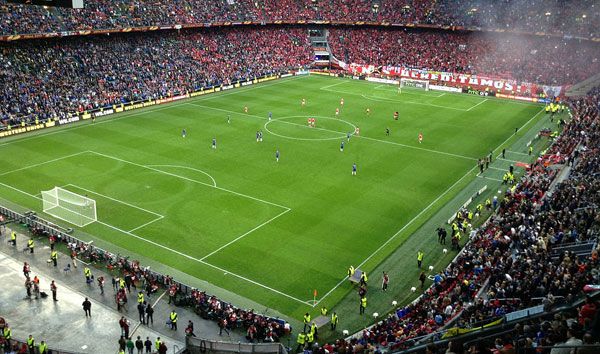
2012-13 Europa League final – Chelsea FC vs. SL Benfica, Amsterdam ArenA. Photo credit: Syrcro, licensed under CC 3.0
The Design of Nelson Mandelapark
The redevelopment of the neighborhood’s extensive parklands was a keystone project in the re-branding. Nelson Mandelapark aimed to meet the present and future needs of people living in the neighborhood. Located in such a diverse population, it was necessary for the new design to create a wide variety of recreational opportunities and programming. Luckily, designers had ample space to work with. Diverse Programming for a Diverse Population The new park has seven main entrances, each marked with a distinctive iron gateway that allows the park to be closed at nighttime. The park has an extensive network of pathways, winding through gentle hills and wetlands. With bikes being so ubiquitous to Dutch life, the park is the perfect place for a relaxing bike ride. Other Articles Showcasing Projects by Mecanoo:
- How to Transform a Road into a Spectacular Park
- The Building That Wants to be a Landscape at Delft University of Technology
- How the Aberdeen City Gardens Blend Buildings and History with the Landscape

Nelson Mandelapark. Image courtesy of Mecanoo

Nelson Mandelapark. Image courtesy of Mecanoo

Nelson Mandelapark. Image courtesy of Mecanoo

Nelson Mandelapark. Image courtesy of Mecanoo
- Landscape Architecture Now! by Philip Jodidio
- Street Design: The Secret to Great Cities and Towns by John Massengale
Article by Michelle Biggs Return to Homepage