


Author: Land8: Landscape Architects Network

Urban Jungle Created to Perfection by Agence TER
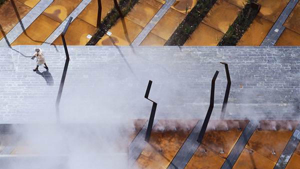
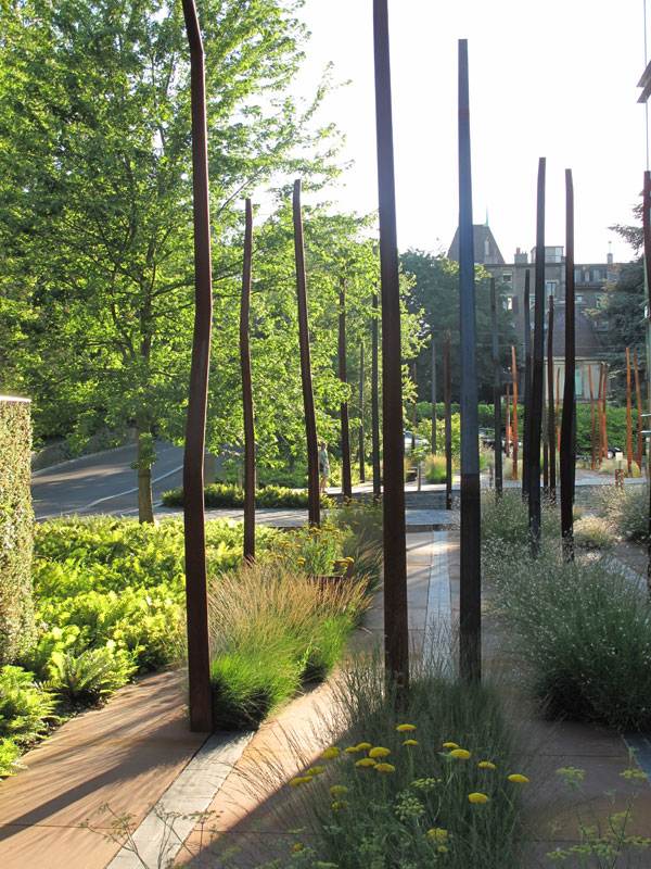
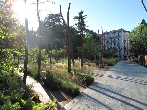
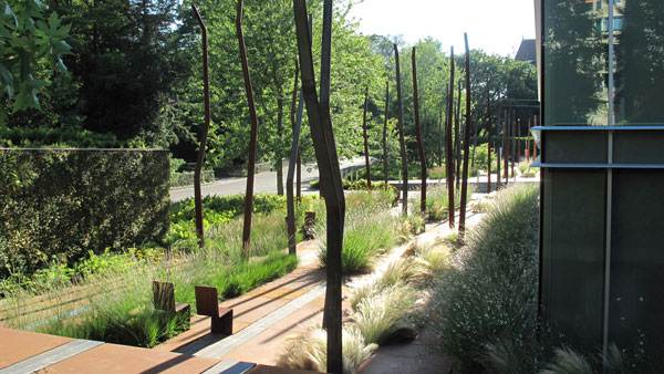
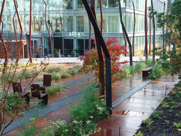
Floor Works, Agence TER Landscape Architects, Geneva, Switzerland. Geneva is the second most crowded city in Switzerland and is often described as a modern concrete jungle. This urban center is densely populated, and the need for more green spaces is often felt. A project developed by Agence TER Landscape Architects was a finalist for the European Garden Award in 2013. The name of the project is “Floor Works” and it concerned the development of an urban garden. The project was commissioned by a private company, SPG, and it demonstrated that a green space can be perfectly integrated within concrete and other urban elements.
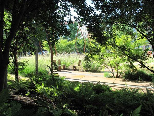
Floor Works. Image: ©agenceter
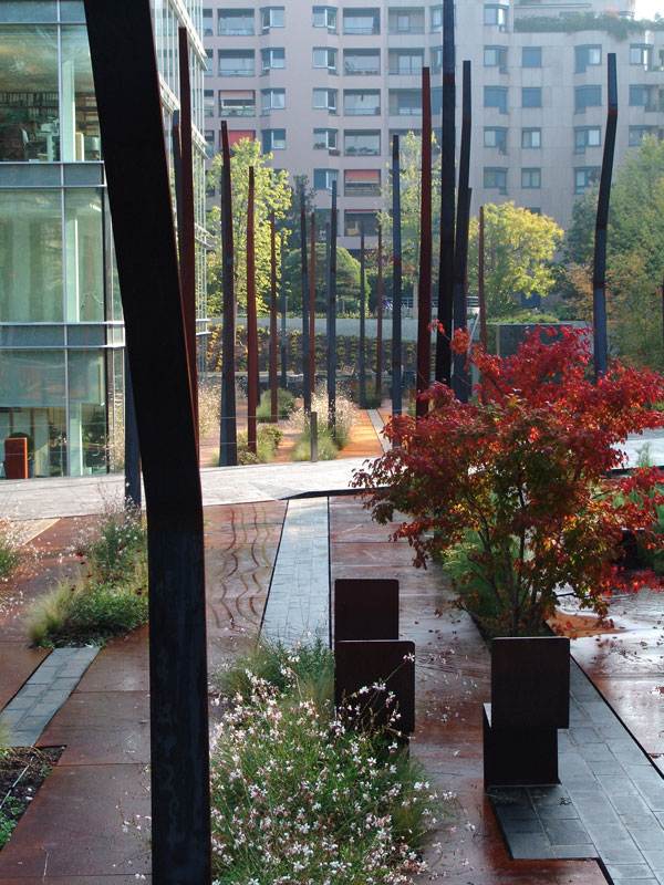
Floorworks. Image: ©agenceter
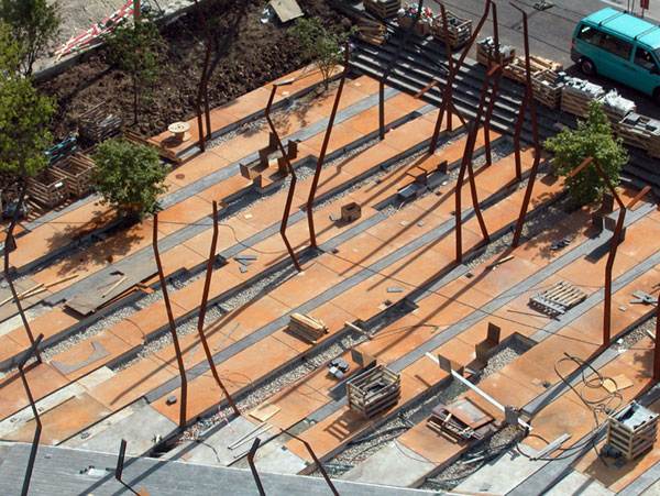
Floorworks. Image: ©agenceter
Floorworks. Image: ©agenceter
Floorworks. Image: ©agenceter
- Lotus Lake Park Sets Precedent for Sustainable Urban Design in China
- Contemporary Landscape Architecture in China: Beautiful or Dangerous?
- Awesome Plaza Shows You Why China Are World Leaders in Landscape Architecture
Floorworks. Image: ©agenceter
Floorworks. Image: ©agenceter
Floorworks. Image: ©agenceter
- Urban Design by Alex Krieger
- The Urban Design Handbook: Techniques and Working Methods (Second Edition) by Urban Design Associates
Article by Alexandra Antipa Return to Homepage

Modern Meets Mediterranean in an Outstanding Private Garden Design
Vale do Lobo — Vila 1148, by Iúri Chagas, Algarve, Portugal. Have you ever wondered, what is the key to a successful design? Perhaps no one has discovered the universal formula, but we all have some assumptions on the subject. And so do the designers of the high-quality private garden project you are about to view. Undoubtedly, there were many aspects considered by the designers, all of which contributed to the final result. To gain key insights into what makes this private garden a perfect example of innovative and contemporary landscape design, you should prepare to find yourself mesmerized by the exotic character of sunny Portugal and its fascinating residential landscaping.
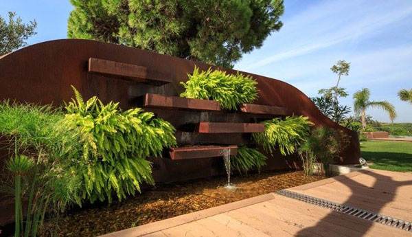
Photo credit: Iúri Chagas
The Concept of the Private Garden Design
It’s easy to be captivated by that specific picturesqueness, typical of Mediterranean regions such as the one where the private house of the project is located — Vale do Lobo golf resort in the Southern Portuguese region of Algarve. As we speak of Mediterranean climate zones, it’s important to highlight that the overall design concept is closely bound up with the climatic conditions of the site.
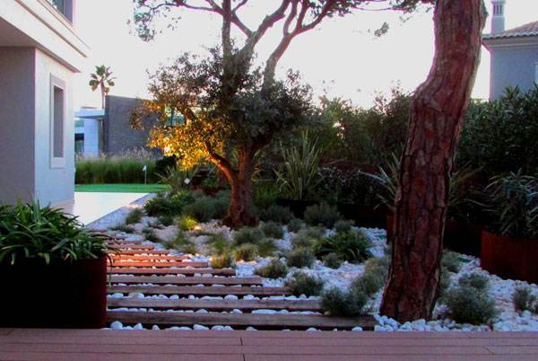
Photo credit: Iúri Chagas
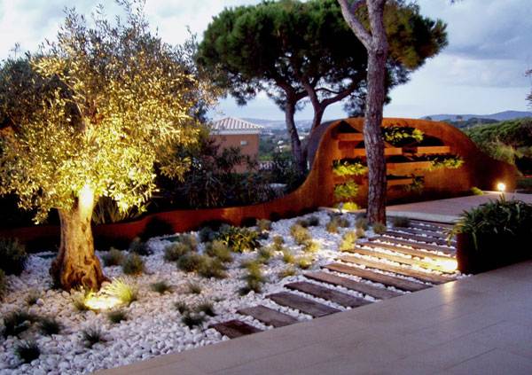
Photo credit: Iúri Chagas
- Award Winning Small Garden Design
- Stunning Contemporary Garden Design!
- Designer Achieves Outstanding Results With Terraced Garden
Sustainable Measures The choice of Mediterranean design is influenced by a number of factors, the most important of which is the climate. Algarve comes under the Mediterranean climatic type, characterized by dry, arid regions with little rain throughout the year. This means that there is great concern about water storage.
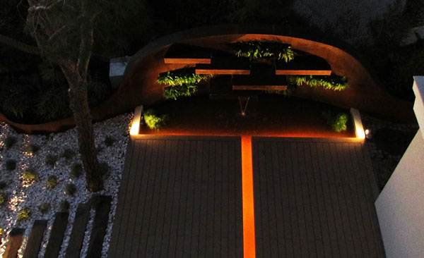
Photo credit: Iúri Chagas
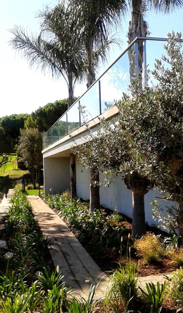
Photo credit: Iúri Chagas
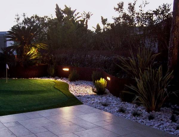
Photo credit: Iúri Chagas
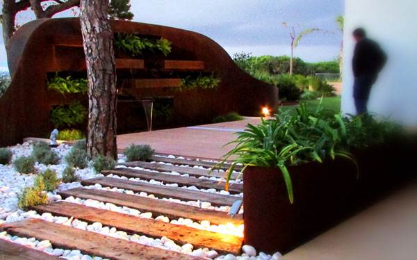
Photo credit: Iúri Chagas
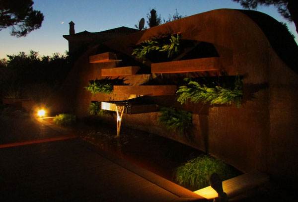
Photo credit: Iúri Chagas
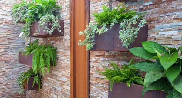
Photo credit: Iúri Chagas
- Urban Design by Alex Krieger
- The Urban Design Handbook: Techniques and Working Methods (Second Edition) by Urban Design Associates
Article by Velislava Valcheva Return to Homepage

Amazing Urban Revitalization: The Creative Power of Collaborative Design
Masonic Amphitheatre and Smith Creek Pedestrian Bridge, by design/build LAB, Clifton Forge, Virginia, USA. Revitalization, renaissance, resurrection: All of these words are used to describe the same thing — a process of physical and spiritual renewal. Too often, these are empty words. But sometimes someone comes along and makes them real. This is a story about that someone(s) – students who collaborated with a local community and industry to design and build an architectural work that is not only charitable, but educational in its essence. This story wouldn’t be possible without design/build LAB, a project-based experiential learning program that successfully killed two birds with one stone: The program supported the urban redevelopment of the distressed community in the town of Clifton Forge, Virginia, and at the same time gave students the chance to gain lifelong practical experience through the creation of a new, high-quality built environment.

Masonic Amphitheatre and Smith Creek Pedestrian Bridge. Photo © Jeff Goldberg/ESTO
Urban Revitalization and a Magnetic Public Space
As a significant part of the complete project, the Masonic Amphitheatre provides a much-needed performance space for the citizens of Clifton Forge. Like a magnet to the public, the interactive design captivates through its bold, innovative appearance.

Masonic Amphitheatre and Smith Creek Pedestrian Bridge. Photo © Jeff Goldberg/ESTO

Masonic Amphitheatre and Smith Creek Pedestrian Bridge. Photo © Jeff Goldberg/ESTO

Masonic Amphitheatre and Smith Creek Pedestrian Bridge. Photo © Jeff Goldberg/ESTO

Masonic Amphitheatre and Smith Creek Pedestrian Bridge. Photo © Jeff Goldberg/ESTO
- Top Ten Names in Landscape Architecture
- 10 Incredible Projects For Students To Know About And Why!
- The World Without Landscape Architects!

Masonic Amphitheatre and Smith Creek Pedestrian Bridge. Photo © Jeff Goldberg/ESTO

Masonic Amphitheatre and Smith Creek Pedestrian Bridge. Photo © Jeff Goldberg/ESTO
Seamless Recreation in this Urban Revitalization
All around landscaped areas fill the park with new sensations of blissful recreation. The grass line along the creek, the adjacent butterfly garden, the beach, the series of grass lawns at the center — all contribute to the whole-hearted, astonishing end result of the project.

© Jeff Goldberg/ESTO

Masonic Amphitheatre and Smith Creek Pedestrian Bridge. Photo © Jeff Goldberg/ESTO
- The Garden Source: Inspirational Design Ideas for Gardens and Landscapes by Andrea Jones
- Private Paradise: Contemporary American Gardens by Charlotte M. Frieze
Article by Velislava Valcheva Return to Homepage


The Many Fascinating Water Features of Central Park of Hunnan Axis in China
Central Park of Hunnan Axis, By Niek Roozen Loosvan Vliet, with: Urhahn Urban Design and Landscape Institute Shenyang, Shenyang, China China is making huge efforts to improve its relationship with water — our most precious resource. This is due to its historical importance to the country’s development, as we have seen in the article Is China Transforming its Relationship with Water? A Look at the Aiyi River Landscape Park, . In Hunnan Axis Central Park, it is no different – water is beautifully represented throughout the park, sometimes portrayed as calm and serene in the form of ponds, or as vigorous and lively in the form of water jets. The truth is, this dynamic element can create stunning aesthetic results in the urban scene (and even energize wealth luck to the surrounding neighborhoods).
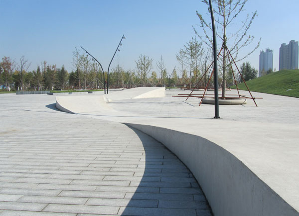
Photo Credit: Central Park at Hunnan Axis by Niek Roozen Loosvan Vliet
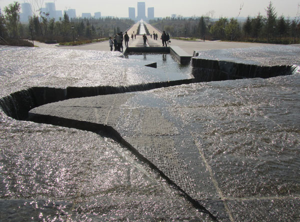
Photo Credit: Central Park at Hunnan Axis by Niek Roozen Loosvan Vliet
A Park Full of Water Features
Running in line with the Hunnan Axis, this 300-meter-wide, four-kilometer-long park offers an amazing display of various water features, including canals, waterfalls, water jets, and ponds. Covering a total area of 130 hectares, it was designed in 2011. Construction started that same year, reaching its completion in autumn 2013. The context-sensitive approach adopted by the designers is clearly displayed in the water features, which reflect the orthogonal pattern of the district’s master plan. Also, its bold scale emphasizes the strict geometric forms for a big visual impact, which is counterbalanced by the calming effect of water.
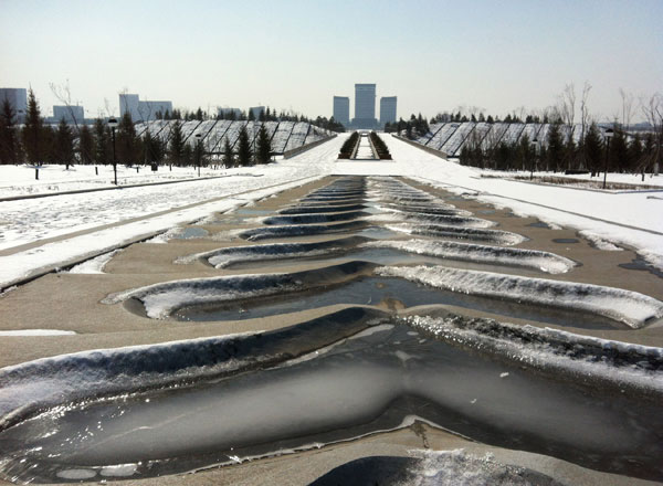
Photo Credit: Central Park at Hunnan Axis by Niek Roozen Loosvan Vliet
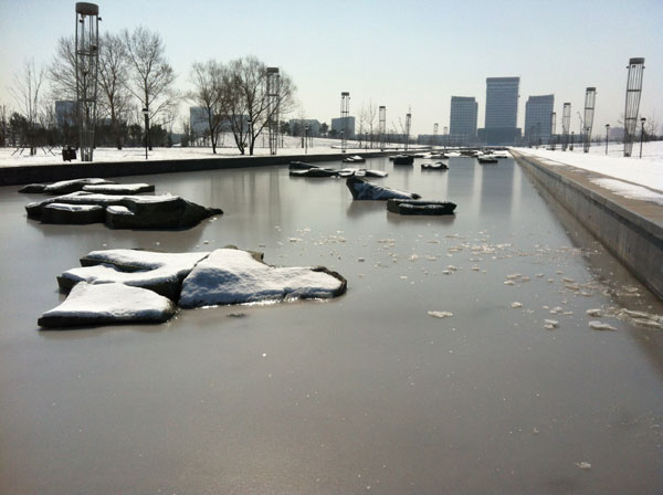
Photo Credit: Central Park at Hunnan Axis by Niek Roozen Loosvan Vliet
- Lotus Lake Park Sets Precedent for Sustainable Urban Design in China
- Contemporary Landscape Architecture in China: Beautiful or Dangerous?
- Awesome Plaza Shows You Why China Are World Leaders in Landscape Architecture
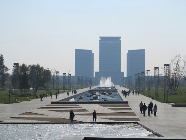
Photo Credit: Central Park at Hunnan Axis by Niek Roozen Loosvan Vliet
The Water Features
The use of water as an ornamental feature has long been a staple of traditional Chinese landscape design. In Feng Shui, this is a crucial component to activate prosperity and increase income if the location and direction of flow are auspicious. Hills located to the north, from which a stream flows heading south, is supposed to attract great financial luck (as water is the ultimate money and wealth symbol in Feng Shui cosmology).
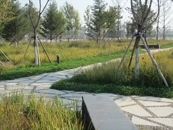
Photo Credit: Central Park at Hunnan Axis by Niek Roozen Loosvan Vliet
- Urban Design by Alex Krieger
- The Urban Design Handbook: Techniques and Working Methods (Second Edition) by Urban Design Associates
Article by Julia Lucchese Return to Homepage

How to Preserve Nature, While Creating an Environment for People
Dzintari Forest Park, Substance SIA, Jurmala, Latvia. Jurmala is a Latvian city situated close to the country’s capital, Riga. It is also one of the largest resorts in the entire Baltic region, well known for its mineral springs and sulphurous and medicinal waters. In an effort to increase the appeal of the city, a program for the reconstruction of Dzintari Forest Park was developed between 2007 and 2010. The program was requested by the Jurmala City Council and was designed by Substance SIA. The architects responsible for the project were Arnis Dimins and Brigita Barbale. The actual building was handled by Taders SIA. The project turned out to be a success, demonstrating that nature can be preserved while creating an active environment for people.

Dzintari Forest Park. Photo credit: Ansis Starks

Dzintari Forest Park. Photo credit: Ansis Starks

Dzintari Forest Park. Photo credit: Ansis Starks

Dzintari Forest Park. Photo credit: Ansis Starks

Dzintari Forest Park. Photo credit: Ansis Starks
- Top Ten Names in Landscape Architecture
- 10 Incredible Projects For Students To Know About And Why!
- The World Without Landscape Architects!
As it was already mentioned, the forest park had some walking paths. These were reconstructed with the aid of cobblestones, an aesthetic improvement. The designers were interested in bringing people of all ages to the newly designed park. This is why they have made an active recreation area, providing an inline skating track as one of the most interesting elements. The project also included the building of a pedestrian bridge constructed out of rope net between the skating area and the pedestrian paths.

Dzintari Forest Park. Photo credit: Ansis Starks

Dzintari Forest Park. Photo credit: Ansis Starks
- The Garden Source: Inspirational Design Ideas for Gardens and Landscapes by Andrea Jones
- Private Paradise: Contemporary American Gardens by Charlotte M. Frieze
Article by Alexandra Antipa Return to Homepage


Award Winning Office Campus Design at The Cox Enterprises Gardens by HGOR
The Cox Enterprises Gardens, by HGOR, Atlanta, Georgia, USA. While some people may have to commute after work hours to access outdoor green areas, others are already benefitting from the integration of their offices with green space. The park-like gardens in the surroundings of some business buildings are attractive spaces, but they have a high initial investment, which discourages their creation. However, some very successful cases — such as the Cox Enterprises Gardens — may encourage other companies to adhere to this practice, benefitting not only the workers that will use the gardens, but also the neighborhoods that will share a healthier and more aesthetic environment.
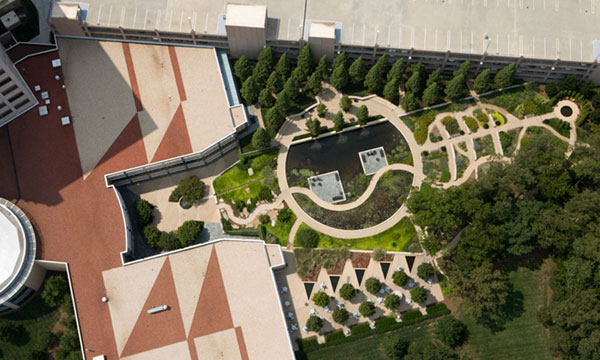
Photo credit: Cox Enterprises Gardens by HGOR
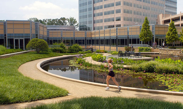
Photo credit: Cox Enterprises Gardens by HGOR
A Blend of Traditional and Contemporary Styles in this Stunning Office Campus Design
The designers created an outdoor space inspired by traditional geometric forms and with the flexibility of contemporary aesthetics. This combination of formal shapes and free lines resulted in a dynamic composition featuring the circular pond as its central component. As a mirror, the water surface reflects the surrounding environment and works as the focal point where all the elements converge. In this space, integration was preferred over symmetry, but this dissonance with the classic rules did not compromise the balance of the composition since the plants, furniture, and hardscape elements were harmoniously organized. They were placed to define sectors that are not strictly separate so that the pathways, seating area, and ribbons of trees cross the limits of the circle, enabling a more dynamic interaction with the different components of the gardens.
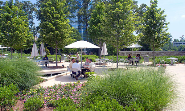
Photo credit: Cox Enterprises Gardens by HGOR
Photo credit: Cox Enterprises Gardens by HGOR
The Integration of the Landscape Within the Office Campus Design
The buildings and the gardens are gently connected by sharing some common characteristics while keeping their independence and a sense of their own identity. While a front view shows us the convergence of axes linking the building structure to the gardens paths, an aerial view of the gardens shows the set of geometric shapes uniting the building’s roof to the landscape, as a woven tapestry of neutral colors surrounded by the green of the trees and plants. As a mosaic composed by formal shapes – triangles, squares, and circles — and organic forms, the landscape matches the multifunctional program through an innovative design. Related Articles:
- Bill and Melinda Gates at the Forefront of Sustainable Design
- 10 Practices Showing That “Sustainability” is More Than Just a Buzzword!
- Lotus Lake Park Sets Precedent for Sustainable Urban Design in China
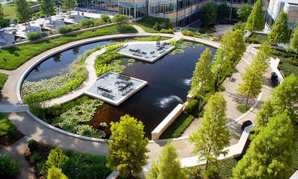
Photo credit: Cox Enterprises Gardens by HGOR
- Urban Design by Alex Krieger
- The Urban Design Handbook: Techniques and Working Methods (Second Edition) by Urban Design Associates
Article by Tania Gianone Return to Homepage

Reinterpreting Nature in Design: Teikyo Heisei University Nakano Campus
Teikyo Heisei University Nakano Campus, by Studio on Site (Hiroki Hasegawa), Tokyo, Japan There is a certain type of landscape where people just feel good, without realizing the reason for that. Teikyo Heisei University Nakano Campus is undoubtedly one of those exceptional places. A place which has something more to offer. A feeling, a sensation, a perfect harmony. The secret to achieving such an effect is partly revealed in the philosophy of Studio On Site. “Although our work covers a wide range, we always emphasize the “experience of a place” and consider how a given activity will come to be positioned in society and on the specific site. We believe that landscape design is not due to the structure of the new form but a given activity always has something to do with the change in shape or appearance of what is already on the site”, says the team that designed Teikyo Heisei University Nakano Campus. They certainly didn’t forget to follow this ultimate belief within this project!

Photo Credit: Teikyo Heisei University Nakano Campus, by Studio on Site. Photographer: Katsuhisa-Kida/FOTOTECA
Representing Nature in Design
The major concept of the landscape design is inspired by something simple, and yet genius. You can see it. You can touch it. It is all around you –Nature. The reinterpretation of nature in Teikyo Heisei University Nakano Campus is achieved through a repeated square-shaped pattern. The scattering of black pavement covers both interior and exterior floors. The concept of this dispersion is to represent the sunshine filtering through foliage. Thus instilling visitors with a pleasurable sensation or one of a kind experience of the site.

Photo Credit: Teikyo Heisei University Nakano Campus, by Studio on Site.
Design and Function Symbiosis When Representing Nature in Design
Besides the creative and aesthetic functions of the flooring, the paving also performs a directing role. This pavement pattern is a “marker” which shows where to stay in the campus. Conversely, the road zones without that motif are intended mainly for pedestrian circulation. The flooring pattern also varies vertically and horizontally by each sample unit. This difference in levels suggests diversity of uses and activities. A must-have in such a great example of public space.

Photo Credit: Teikyo Heisei University Nakano Campus, by Studio on Site. Photographer: Katsuhisa-Kida/FOTOTECA
- 10 Great Places to Study Landscape Architecture in the USA
- 10 Great Places to Study Landscape Architecture in Europe
- Elegant Square sets stage for University Students

Photo Credit: Teikyo Heisei University Nakano Campus, by Studio on Site.

Photo Credit: Teikyo Heisei University Nakano Campus, by Studio on Site. Photographer: Katsuhisa-Kida/FOTOTECA

Photo Credit: Teikyo Heisei University Nakano Campus, by Studio on Site. Photographer: Katsuhisa-Kida/FOTOTECA
- 1000 Details in Landscape Architecture: A Selection of the World’s Most Interesting Landscaping Elements by Francesc Mola
- Street Design: The Secret to Great Cities and Towns by John Massengale
Article by Velislava Valcheva Return to Homepage


Creative Outdoor Gym in a Modern Community Park
The Pulse Park, by Cebra, Kildebjerg Ry, Denmark. Kildebjerg Ry, Denmark, is an attractive area for living because of its natural environment, which encourages residents to practice all kinds of sports activities. Ry, where the residential development Kildebjerg Ry is located, is part of the Skanderborg municipality in Jutland, the peninsula that juts out in Northern Europe to form the mainland part of Denmark. The town, with a population of only 5,731, is located in central Denmark along the Guden River and surrounded by a spectacular chain of lakes. When the community expressed its wish to develop a system of leisure and sport activities, Cebra Architecture, a Danish design practice founded in 2001 and based in Aarhus, was asked to design the concept of a community activity project.

Pulse Zone. Photo credit: Mikkel Frost
The Call for an Outdoor Gym
The community requested that the park have three innovative zones designed for different sports activities, allowing residents to work out, relax, and do yoga while socialize with neighbors in a park that looks like a playground. Another request of the community referred to landscape and park integration in a harmonious way. A park to keep residents in shape The Pulse Park, suggestively named after the medical word, is a predominantly mineral park, with three different areas: the Play Zone, the Pulse Zone, and the Zen Zone, connected by a network of flashing LED trails and pathways that rise and fall for even greater challenges.

The Play Zone. Photo credit: Mikkel Frost

The Play Zone. Photo credit: Mikkel Frost
- How to Design a Landscape for Extreme Workouts: Part 1 Calisthenics
- New Park Design Spices Things up in Old Scene
- Superkilen: A Public Space to Feel at Home

Pulse Zone. Photo credit: Mikkel Frost

The Zen Zone. Photo credit: Mikkel Frost

The Zen Zone. Photo credit: Mikkel Frost

The Zen Zone. Photo credit: Mikkel Frost
- Designing Small Parks: A Manual for Addressing Social and Ecological Concerns by Ann Forsyth
- The Urban Design Handbook: Techniques and Working Methods (Second Edition) by Urban Design Associates
Article by Diana Ispas. Return to Homepage


7 Google Hacks for Landscape Architects That Will Have You Googling like a Pro
Learn how to Google beyond the basics with these Google Hacks and enhance your ability to perform as a landscape architect. The Google search engine has become ubiquitous in modern life. As much as 77% of all internet searches are performed using Google, with Statista placing last months figures at 1.17 Billion worldwide Google users! No doubt Google is a powerful search engine, but do you use it to its full potential? Here I share with you some of the Google hacks I’ve learned over the years that have helped me, in my work as a landscape architect.
Google Hacks
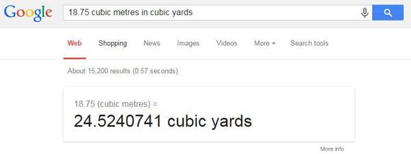
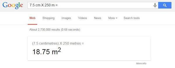
1. Calculating and converting This is a really simple and easy Google hack for landscape architects. If you want to quantify the amount of mulch you will need for any given area, simply type the equation into Google. For example, a 7.5 centimeter depth of mulch over a 250 square meter area gives a total volume of 18.75 cubic meters of mulch. Want that in imperial? Simply ask Google: “18.75 cubic meters in cubic yards”.
Printscreen of using the Google conversion table.
Screenshot of using Google to do the maths for you.
2. Location, location, location As the old real estate saying goes “Location is everything”. When you search from a particular location Google will normally redirect you to a local version of their page e.g. Google.fr for France or Google.co.uk for the United Kingdom. However, you may be researching a particular project in another country. To circumnavigate Google’s location redirection, simply search from www.google.com/ncr. The NCR stands for ‘No Country Redirect‘. This takes you to the generic worldwide Google site in English. There is also the handy No Country Redirect Chrome plug-in available for free from the Chrome Web Store that will automatically do this for you. Related Articles:
- 6 Surprising Tricks You Need to Know for a Site Visit
- 10 Practices Showing That “Sustainability” is More Than Just a Buzzword!
- 9 Facts About Landscape Architecture That You Didn’t Know!
Alternatively, you may want to search for a specified location that you are not currently in. Say you have just won that prestigious contract in China or Australia, and want to search for construction materials that are available in that country. If signed into Google you can go to Settings> Advanced Search and set your preferred country to search from, and your preferred language for search returns. Doing this saves you having to always go to Advanced Search and changing the settings there every time you search. 3. Safety First Perhaps I’m naïve, but I learned this the hard way. When performing an image search for terms that have a potentially embarrassing double meaning, such as “holly bush”, “Rose Bed”, or “Dutch hoe”, its best to ensure you have engaged ‘Safe Search‘. When searching Google, simply go to Safe Search at the top right of the screen and make sure ‘Filter Explicit Results‘ is checked. 5. Spell check There are many advantages to being dyslexic, sadly good spelling is NOT one of them. I am always plagued by not remembering how to spell words. Especially Latin plant names. Google has become increasingly clever over the years, and now has very sophisticated spell checking capabilities. If you are unsure of how to spell a word, and don’t have a word processor open on you computer, simply type your best guess into Google and let Google work it out for you.
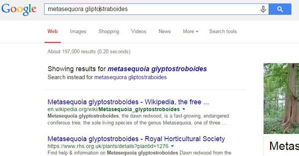
Screenshot of using Google to tackle tricky latin plant names.
4. Quotation Searching for, Quercus ilex will return pages that contain both Quercus and ilex. These results may include pages about many different species of Quercus (of which there are over 600) and even some pages dedicated to the genus of Ilex (yet another 400-600 species). By putting your search term in “quotation” marks, Google will return results that only pertain to that exact phrase i.e. the specific plant “Quercus ilex”. 6. Can’t remember that species name? Sometimes when searching for a particular plant you might forget the species, genus, or part of the cultivar name. This is a Google hack that can really help us out. Simply put the search term in quotation marks and replace the part of the name you can’t recall with an asterisk. For example: “Photinia X * Red Robin” or “Acer rubrum * Glory”. When searching, Google will understand that the asterisk could be any word, and so will search for the term in word order, but leave a ‘space’ where the asterisk is, thus returning results that are more likely to be close to what you are looking for. 7. Google Shortcuts Google can be used as a dictionary, weather app, address, and zip/postal code finder as well as a calculator. Simply type in “Define:” followed by your term, for example “Define: Architectural Engineering”. Similarly if you are going to site, or need to check the weather for your site, simply put the zip or postal code into Google, preceded by “weather” to get a succinct weather report for your site. Similarly, if you can’t recall the address of a particular place or site, simply ask Google.
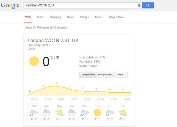
Screenshot of using Google to predict the weather in a specific location.
In the example below I found the address and postcode for the Landscape Institute in the UK without having to go to their website, and look to see if there is a “Contact Us” page or if their address is on the page footer, thus saving time.
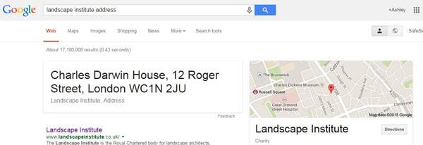
Screenprint showing a shortcut for finding locations.
Google Hacks are a Real Timesaver
Google is such a ubiquitous search engine that it can be easy to take it for granted, but by learning how to use simple Google hacks landscape architects can find what they are looking for quicker, and easier. Whether its saving time letting Google assist you with quantifying, checking the weather on site, or finding construction materials that are actually available in the country you’re working in; Google hacks can significantly help you out.
Recommended Reading:
- 1000 Details in Landscape Architecture: A Selection of the World’s Most Interesting Landscaping Elements by Francesc Mola
- Street Design: The Secret to Great Cities and Towns by John Massengale
Article by Ashley Penn


Three Things to Consider When Purchasing a Garden Shed
Utilising an outdoor space or garden can be an excellent solution to a number of problems. Garden sheds are versatile outdoor equipment that are specifically designed to deliver beauty, durability, and strength. Whether you want to indulge in a new gardening hobby or store your old tools, consider these three factors before you buy a shed. The finest material and the highest quality Wooden sheds are the most common and traditional, but the exact type of wood will make a difference to a shed’s upkeep and longevity. Cedar wood sheds are the most resistant to rot, but you could buy a pine one for half the price, so think carefully about your budget. In contrast, purchasing a plastic or metal version will remove the problem of rot entirely.

Garden shed image contributed by Samantha Waites from EMediaBuyers.com


How Beirut’s Zeytouneh Square is Reuniting a Divided Urban Community
Zeytouneh Square, by Gustafson Porter, in Beirut, Lebanon. Lebanon’s capital, Beirut, is an ancient city that predates even recorded history. In the 1960s, it was considered one of the world’s most vibrant and diverse cities — a center for arts, culture, and tourism. But in 1975, Lebanon was plunged into a civil war that devastated the nation, tearing communities apart, both literally and figuratively. This civil war came to an end in 1990, but the country is still piecing together communities ruined by a war whose aftermath continues to resonate in daily life.

Beirut’s evolving shoreline from Phoenician times until Solidere’s redevelopment. Image credit: Gustafson Porter
Zeytouneh Square
Rebuilding Beirut’s infrastructure and identity with public space Today, Beirut is a city at a crossroads. The destruction of the capital was immeasurable. With so much of the city’s physical infrastructure destroyed, much of Beirut has had to be rebuilt from scratch. Even worse, the war has left the community divided. However, Beirut now has an opportunity to forge a new image for itself. It aims to build a city that reflects the country’s post-war identity while still respecting the historical context and, above all, reunites an urban community divided by war and strife.

Zeitouneh Square design feature detail. Image credit: Tony El Hage

Aspect from the viewing terrace looking towards the Shoreline Gardens. Image credit: Gustafson Porter
Zeytouneh Square: a transitional space
Zeytouneh Square is a keystone project in this redevelopment. Designed by award-winning landscape architecture firm Gustafson Porter and opened to the public in 2012, Zeytouneh Square is one public space part of larger project: Beirut’s Shoreline Walk, a linear corridor of public spaces through the heart of downtown.

Zeitouneh Square. Image credit: Gustafson Porter

Zeitouneh Square public art event: Shattered Sun by Anachar Basbous. Image credit: Solidere

Zeitouneh Square water feature detail. Image credit: Solidere
. Image credit: Tony El Hage")
Zeitouneh Square site aerial shot (detail). Image credit: Tony El Hage
- Contemporary Landscape Architecture in China: Beautiful or Dangerous?
- Shipyard Site Transforms into Stunning Ecological Park
- Lotus Lake Park Sets Precedent for Sustainable Urban Design in China
The use of water on site is also significant. Simple pools with jets and a stream-like water feature contribute to the atmosphere, creating relaxing, ambient sounds while injecting animation and life into the space. These features are open and accessible to users, allowing for opportunities for direct interaction and water play.

Zeitouneh design features. Image credit: Tony El Hage

Zeitouneh Square design feature detail. Image credit: Tony El Hage

Zeitouneh Square design feature detail . Image credit: Tony El Hage
- Urban Design by Alex Krieger
- The Urban Design Handbook: Techniques and Working Methods (Second Edition) by Urban Design Associates
Article by Michelle Biggs Return to Homepage


How Mesa City is Giving us a Great Lesson in Public Participation
Mesa City Center, The Wind Dancer — Colwell Shelor + West 8 + Weddle Gilmore, Mesa, Arizona, USA. I bet that if you aren’t American, you have never heard of the city of Mesa, right? And why should you, even though it’s the third-largest city in the state of Arizona. It is an American city similar to many others. Spread over 133 square miles (344.5 square kilometers), Mesa is part of the large metropolitan area of Phoenix. It is a typical American suburb surrounded by highways, with no significant landmark to distinguish its identity from the rest. So what is Mesa doing to get our attention? Well, city officials have decided to create what they don’t have – a landmark to give the city a new identity and a public space that will increase the quality of life for its citizens, invite diverse activities into the city center, and serve as an activator for the densification and high-intensity redevelopment process downtown.

Aerial context future growth. Image courtesy of Colwell Shelor + West 8 + Weddle Gilmore
Mesa City Design Competition
The idea for a new public space design was approved in 2012 by city residents, who voted to fund the project with park bonds. At the end of 2013, the city launched a competition seeking designs for the space. The design teams worked intensely with the community and strongly considered public opinions in order to address the inhabitants’ needs. The three final designs were announced in August 2014, and after public discussions, the design team of Colwell Shelor, West 8, and Weddle Gilmore was selected as the winner.

Sky terrace. Image courtesy of Colwell Shelor + West 8 + Weddle Gilmore
- What are your priorities?
- How could this project be a catalyst for reinvigorating downtown Mesa?
- What would make you come here again and again?

Neon Plaza. Image courtesy of Colwell Shelor + West 8 + Weddle Gilmore

Wind Dancer at day and the night. Image courtesy of Colwell-Shelor-+-West-8-+-Weddle-Gilmore

Summer and Winter water feature. Image courtesy of Colwell Shelor + West 8 + Weddle Gilmore
The upper terrace. Image courtesy of Colwell Shelor + West 8 + Weddle Gilmore

Arts center at night. Image courtesy of Colwell Shelor + West-8 + Weddle Gilmore
- 6 Reasons Why Our Future Depends On Landscape Architecture
- Visionary Smart Cities Offer a Glimpse of The Future
- Stunning New Train Station Brings Landscape to Center of City

Aerial perspective at night. Image courtesy of Colwell Shelor + West 8 + Weddle Gilmore

The arrival collage east entrance. Image courtesy of Colwell Shelor + West 8 + Weddle Gilmore.

Civic promenade. Image courtesy of Colwell Shelor + West 8 + Weddle Gilmore.
- Site Engineering for Landscape Architects by Steven Strom
- The Artful Garden: Creative Inspiration for Landscape Design by James van Sweden
Article by Yuliya Georgieva Return to Homepage