


Author: Land8: Landscape Architects Network


One Canal | A Luxurious Oasis for the Residents of Boston
Article by Lidija Šuster – One Canal, by Copley Wolff Design Group, in Boston, Massachusetts, USA. Large cities are mainly characterized by tall and expressive buildings, business and educational centers, industrial facilities, shopping malls, and other various types of urban areas. When it comes to residential living many of them offer very luxurious residences, and Boston is no exception. Boston is the capital of Massachusetts, and also the largest city in the New England region of the northeastern United States. Its famous linear park, the Rose Fitzgerald Kennedy Greenway, holds many interesting landscapes and places for living, including the One Canal project.
One Canal. Photo credit: Copley Wolff Design Group
One Canal. Photo credit: Copley Wolff Design Group
One Canal
Supporting Life in the Heat of an Urban Area
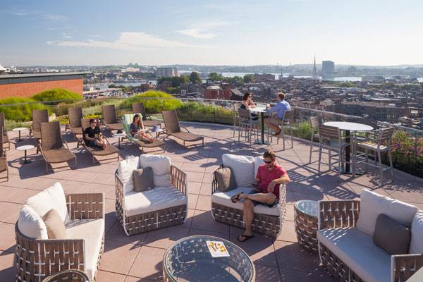
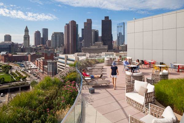
Considering its capacity and cost, One Canal has a lot to offer for its residents and visitors. Including vast space reserved for residential and retail purposes, this project emits a stunning impression of luxury. From the ground level all the way up to the 12th floor, everything has been carefully planned so that spatial organization provides its fullest potential. According to the building’s planners, the entrance is arranged to visually and historically refer to the Middlesex Canal that once flowed throughout the site.

One Canal. Photo credit: Copley Wolff Design Group
One Canal. Photo credit: Copley Wolff Design Group
Representing Nature
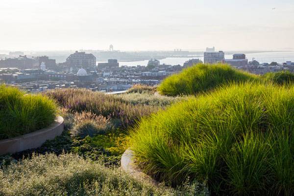
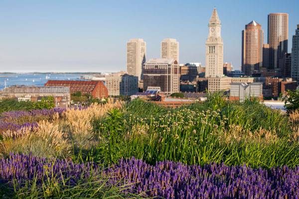
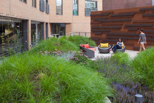
“An amenity roof deck“, so called by the designers, offers a wide range of possibilities for enjoying the space. Curved edges blended with wavy embankments support the natural look, which contributes to the relaxing and comfortable atmosphere. By using bushy ornamental grasses and flowering perennials, designers provided the spatial impression that is not seen very often above the ground.
One Canal. Photo credit: Copley Wolff Design Group
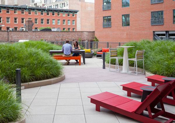
Following the curvy composition, the amenity roof deck is arranged with mounds that look like little grassy hills, providing a whiff of nature to the residents. With different shapes, sizes, heights, and types of plants, these patches of greenery bring dynamism and vibrancy into the living area. Surrounded by this kind of landscape, the space intended for enjoyment can flourish completely. Private niches, decorated with lighting, equipped with cozy, attractive chairs, make the perfect spot for drinking morning coffee or evening beverages.
One Canal. Photo credit: Copley Wolff Design Group
One Canal. Photo credit: Copley Wolff Design Group
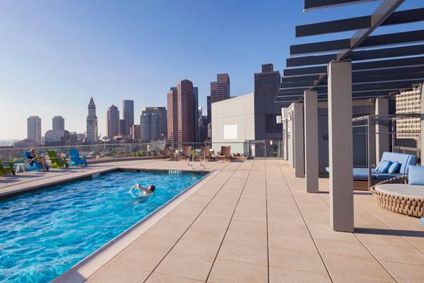
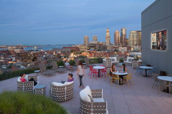
Roof Level Pool Terrace
Another stunning part of the One Canal project is its pool terrace located on the roof. Let’s say that majority of people (myself included) are strongly drawn to pools (and other water elements), so implementing this type of feature was an absolute bingo. With its breathtaking view of the city, the pool is located on an elevated platform, accesed by six wooden stairs (the designer’s concept of using wood material is also transferred to this level).
One Canal. Photo credit: Copley Wolff Design Group
One Canal. Photo credit: Copley Wolff Design Group
One Canal. Photo credit: Copley Wolff Design Group
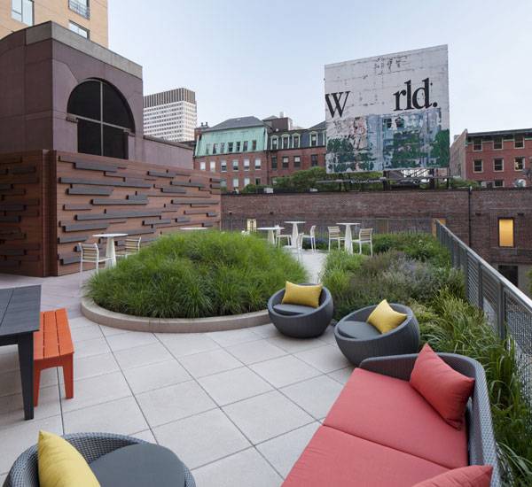
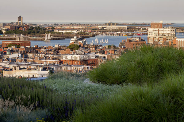
The Outer Edges
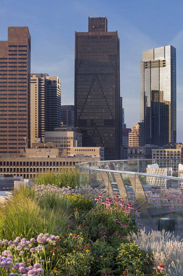
The aforementioned landscape mounds and “grassy hills“ were not just implemented on the inner side of the fence. What gives this project an additional virtue of uniqueness is forming a vegetation belt outside the floor’s edges. Replicating the natural shapes and holding the native plants, these outer edges definitely support the natural landscape look. Combining all of these elements and a view on the Boston’s land from above, One Canal offers a perfect place for condominium living.
One Canal. Photo credit: Copley Wolff Design Group
One Canal. Photo credit: Copley Wolff Design Group
Full Project Credits For One Canal :
Project Name: One Canal Location: Boston, Massachusetts, USA Year Of Completion: 2016 Designers: Copley Wolff Design Group Size: 12-story Building/ 310 Apartments Client: Icon Architecture/trinity Financial Total Development Cost: $195 Million Recommended Reading:
- Becoming an Urban Planner: A Guide to Careers in Planning and Urban Design by Michael Baye
- Sustainable Urbanism: Urban Design With Nature by Douglas Farrs
- eBooks by Landscape Architects Network

Würth La Rioja Museum Gardens | How to Merge Geometry With Nature
Article by Kamil Rawski – Würth La Rioja Museum Gardens, by Pablo Serrano Elorduy, in Agoncillo, Spain. The Würth Museum is located in the northern region of Spain, about 15 kilometres to the east from Logroño, in Agoncillo. This building has been designed as a 21st-century, avant-garde, international, contemporary arts scene. Admission to this interesting architectural building is free (3 € per person, subsidised by Würth España S.A.). And there is an option, with prior reservation, for a free guided tour for groups of more than 10 persons. Try to imagine what kind of garden should be designed for the Würth Museum? What do you think; would an ordinary garden be appropriate to such a place? I think it is not and a similar opinion was held by the designers – Blanca and Pablo Serrano Elorduy. They decided to create a modern space, so below, we can see and read about the results of designing the new, geometrized gardenscape.

Würth La Rioja Museum Gardens, by Pablo Serrano Elorduy
Würth La Rioja Museum Gardens
Main Idea The main premise of the Würth La Rioja Museum Gardens project was to show and use the conditions of the former site and transform it into a new form of landscape. The existing morphological, topographical, and topological configurations were used for this purpose. Designers traced the lines in these schemes and were able to create a virtual grid, which was used to design particular elements of the space. Despite the visual disorder, everything seems to be organized well. In this way, they managed to get to the geometrized ground of the existing site.

Würth La Rioja Museum Gardens, by Pablo Serrano Elorduy

Würth La Rioja Museum Gardens, by Pablo Serrano Elorduy
Geometric Nature
Disordered lines, which are the borders of specific surfaces, refer to elements of nature. We can find connections to forms such as branches, channels, leaves, rivers, and cracks. Thanks to that, it was possible to control each of the different areas to create a new arrangement of space. These irregular lines are also adapted to the solar topography, so as a result they widen and narrow as well as intersect and intertwine.

Würth La Rioja Museum Gardens, by Pablo Serrano Elorduy

Würth La Rioja Museum Gardens, by Pablo Serrano Elorduy
Separated Areas
Landscape designers created not only a usable space but also a harmonious composition of nature with anthropogenic elements. Irregular lines create not only walking tours but also become the rest areas. Every element of the garden, such as trees, herbs, rocks and water sheets, seem to move at the same pace and you can find out about it by walking through this space on a concrete path.

Würth La Rioja Museum Gardens, by Pablo Serrano Elorduy

Würth La Rioja Museum Gardens, by Pablo Serrano Elorduy
Vegetation
The vegetation on this site was planted in isolated irregular geometrical areas. Low plants predominate, but there are also bushes and trees. Shrubs grow mostly near the water and the trees on the peripheral areas. In the case of perennials, each plant species fills a whole separated area making a uniform colour patch.

Würth La Rioja Museum Gardens, by Pablo Serrano Elorduy

Würth La Rioja Museum Gardens, by Pablo Serrano Elorduy
Furnishings
The whole composition is complemented by small architectural objects, and at night also the game of light and shade. The whole area is equipped with benches, single seats, and trash baskets. They are made of concrete and wood to create a consistent composition with the rest of the Würth La Rioja Museum Gardens project. Located on the elevated wooden terrace, there are also tables with chairs. In the garden there are also sculptural elements. At the bottom of the single seats there are mounted lights, which at night create interesting effects; in particular, near the museum entrance, where they are dispersed in greater amounts.

Würth La Rioja Museum Gardens, by Pablo Serrano Elorduy

Würth La Rioja Museum Gardens, by Pablo Serrano Elorduy

Würth La Rioja Museum Gardens, by Pablo Serrano Elorduy
Full Project Credits For Würth La Rioja Museum Gardens :
Project: Würth La Rioja Museum Gardens Site: Agoncillo, Logroño; La Rioja, Spain Architect: Pablo Serrano Elorduy Designer: Blanca Elorduy Collaborators: Ingeniería Torrella Riggers: Joaquín Sierra, Pablo Devalle. Lighting: Cromm Promoter: Würth España S.A. Surface: 11.280 m2 Recommended Reading:
- Becoming an Urban Planner: A Guide to Careers in Planning and Urban Design by Michael Baye
- Sustainable Urbanism: Urban Design With Nature by Douglas Farrs
- eBooks by Landscape Architects Network


Spain’s Got Talent – 10 Examples of Spanish Landscape Architecture
Article by Radenka Kolarov – Following on in our world series we have selected 10 awesome projects that perfectly represents Spanish landscape architecture today. Spain is one of the world’s oldest cultures with a rich heritage that has influenced entire continents. Spain has tons to offer, from chorizos and matadors to flamenco dancing and Spanish guitars. It is the birthplace of the Spanish language, Pablo Picasso and Miguel Cervantes, and attracts millions of visitors every year because of its fantastic architecture and Spanish landscape architecture too. From the innovative playgrounds and multifunctional parks to the amazing solutions for public squares, either you enjoy the blending with nature, or perhaps the very contrast with the environment, but there is no doubt that you will love these projects. So, let’s take a look at some known (and some not-so-known) things about Spanish landscape architecture.
10 Awesome Examples Spanish Landscape Architecture
10. The Playground at Parque Gulliver, architect Rafael Rivera, artist Manolo Martin and designer Josep Vicent “Sento” Llobell Bisbal, in Valencia
WATCH >>> Tilt-Shift | Parque Gulliver | Valencia
Entertainment, fantasy and charm all come together in this amazing park. This children’s kingdom absorbs inspiration directly from sources in literature and combines it with nets, ropes, stairs, passageways, ramps, and much more, providing a perfect entertainment center for children. This scene has been immortalized by the Parque Gulliver, where children can feel like true Lilliputians, climbing and sliding down the colossal figure which is no less than 70 meters in length. Also, it has many other attractions, such as mini golf, skating parks, bicycle lanes, and a giant chess board. No doubt that the Parque Gulliver is a great tourist attraction.
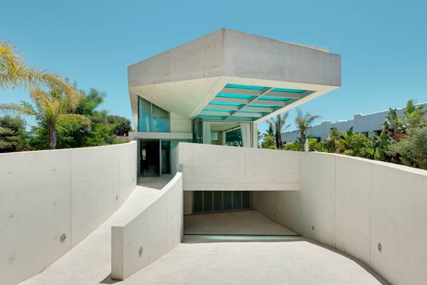
9. The Jellyfish House, by Wiel Arets Architects, in Marbella
In the year 2013, European architecture firm Wiel Arets Architects completed their work on a pool project that will soon become known for its use that reaches beyond conventionalities. Located in the south of Spain, in the Los Monteros, Marbella region, near the Mediterranean Sea, this project has drawn inspiration directly from its environment. With the pool on a rooftop and selected materials like glass panels and concrete joists, it was named “Jellyfish House” by its creators, for it blurs the line between construction and nature. An impression of lightness is also present, while the glass panels act as a pool bottom, making it even more transparent. To complete its integration into the surrounding white surface, the furniture was made in concrete too.
The Jellyfish House. Photo credit: Jan Bitter
8. Torico Square, by b720 Fermín Vázquez Arquitectos, in Torico
Great solutions might come from the minds of architects when it comes to redeveloping and reviving beautiful historical sites. Such is the story with refreshing the historical town center of Torico with an innovative lighting scheme design. Being surrounded by great architectural heritage and with a complex underground water system, the town center of Torico needed to be lighted up by more than 1,200 light sections. Informatics software helped the programmers use different ways of controlling the lights, making them even more attractive. The LED luminaires embedded in the basaltic paving were exclusively designed for this project. The vertical lights were also added to illuminate the surrounding buildings.
Photo Credit: Torico Square by b720 Fermín Vázquez Arquitectos, Teruel, Spain
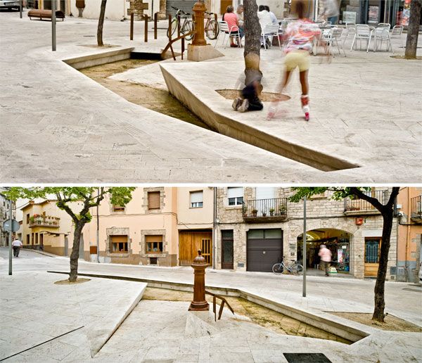
7. Project Banyoles Old Town Remodeling, by Miàs Architects, in Banyoles
Completed in 2011, this remodeling of the Old Town received numerous awards, including the Premis D’Arquitectura Comarques de Girona. When the project was in progress, it was decided that almost all the available space was going to be pedestrianized and that the old sidewalks were going to be removed. The elements of stone and water took a central role in this project. The Old Town’s water canals become part of the sewer system, but the role of water was regained in the end result – restoring the old water canals as they appear intermittently between the recently pedestrianized spaces. The urban planning for this project was a great success, for it took into consideration the fact of many old buildings that were all from medieval times.
Banyoles Old Town Remodeling. Photo credit: Adrià Goula
Atlantic Park. Photo credit: Jorge Póo
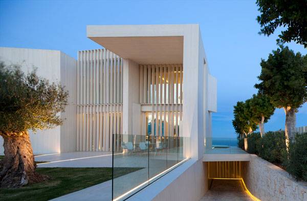
5. Casa Sardinera, by RAMON ESTEVE ESTUDIO, in Jávea, in Alicante
Between EI Portixol and Cala Blanca, surrounded by the Mediterranean Sea, sits Sardinera House. The garden design for this project combines both ecological and economical solutions, reflecting the cultural landscape of cultivation and the consideration of providing habitats for endangered species and diverse plant communities. Considering this, the project offered truly great design that entwines two human activities; constructing the house and protecting the environment. As for the building itself, the concrete walls are repeatedly placed in “ladder” patterns, which condense and enlarge the views. The concrete walls allow the cantilevers to fit in between each other to form a strong connection. Strongly influenced by Mediterranean landscape, this house connects both multi-interior space and outdoor space creatively through the use of landscape. Glass panels also provide the sense of openness that adds to a calm and relaxing atmosphere.
Sardinera House. Photo credit: Mariela Apollonio
4. Plaza de la Luna, by Brut Deluxe, Ben Busche Architects, in Madrid
The famous Plaza de la Luna had problems that needed to be solved. Beside the square, which hadno coherent space, the solution needed to focus on the worst part of the site – the area beneath the arcades. That solution came with the re-formation and creation of a perfect public space, framed with trees, ramps, stairs, and ventilation towers. The center does not determine fixed places for activities but provides the opportunity for diverse uses, such as street markets, musical performances, or sports. In order to make sure that the arcades aren’t too dark – and therefore, attractive to vandals — a new false ceiling is covered with white tiles that reflect the light and give a safer feeling at night. When it comes to the paving of the square, it focuses on texture, with granite blocks of different, highly contrasting colors – white, green, black, and grey.

A landscape acting as an example in our article about designing crime our of landscape architecture. Plaza de la Luna by Brut Deluxe and Ben Busche Architects.
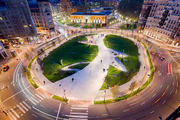
Plaza Euskadi by Balmori Associates in Bilbao, Spain
Indautxu Square. Photo Credit: Elker Azqueta
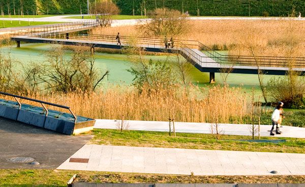
1. Campa de los Ingleses Park, by Balmori Associates, in Bilbao
In the northern part of Spain, close to the famous Guggenheim Bilbao Museum, sits a park known as the “Lung for the City”. Being an array of park spaces and plantings, the topography of the Park was bridged and mediated by ramps, terraces and walls. The paths widen to shape public spaces designed for relaxation and views of the river, the mountains, and the Guggenheim itself. The paving of the Campa de los Ingleses contains an additive called GeoSilex, which absorbs carbon dioxide. Rock gardens reside in ellipse-shaped areas, and single trees are surrounded by circular sitting elements – most of the trees being fruit, broad-leaved trees, and evergreens. Planting grass on different heights emphasizes the topographic differences and shapes. The floodlighting elements are linear and long seating elements are good points for watching the landscape while resting.
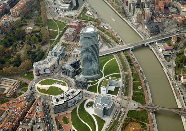
Campa de los Ingleses Park. Photo courtesy Bilboa Ria
Sunny Spain, Much Inspiration to Gain From Spanish Landscape Architecture
The landscapes – from the lush green north, to the mighty Pyrenees, the deserts of Almeria, the Alpujarras, the Rias in Galicia, the wilds of Extremadura… Does it make you wanna go straight to Spain and see all that? Just imagine that adventure! So is the Spanish landscape architecture inspired by its natural environment? Through this list of 10 projects, you can see the diversity of variations in design, and how all the components makes each project special in its own kind of way. Which of these Spanish landscape architecture projects do you prefer and like the most? Let us know in the comment section below!
Recommended Reading:
- Becoming an Urban Planner: A Guide to Careers in Planning and Urban Design by Michael Bayer
- Sustainable Urbanism: Urban Design With Nature by Douglas Farrs


Eden Soestdijk | 6 Steps to Stand Out From The Competition
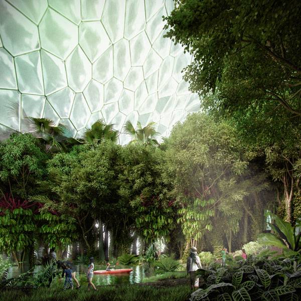
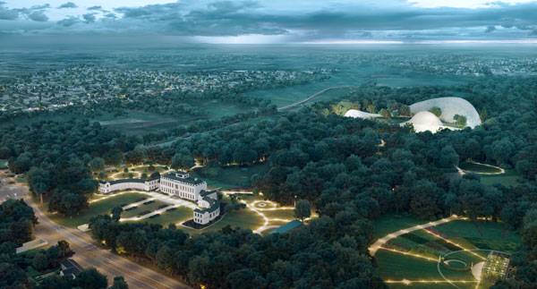
Article by Moreira Filho – Eden Soestdijk, by Mecanoo Architecten, in Baarn, Netherlands Working in landscape architecture requires a variety of knowledge within many multidisciplinary areas of construction. A sum of visual arts, design, architecture, engineering, historical and cultural heritage preservation, laws, botanic, illumination, hydraulic, topography, geology, and others will define whether a project will gather enough elements to win any competition. Wow, being a landscape architect it is not an easy task. A multidisciplinary team composed by Mecanoo Architecten, Kossmann.dejong and Royal HaskoningDHV developed a project for the Soestdijk Estate, transforming it into Eden Soestdijk, in Baarn, Netherlands, in a competition organized by the Dutch government. In fact, this project is an experimental garden whose main goal is to educate and raise awareness in society about the earth’s fragility and the importance of green spaces to the environment and to the people of a sustainable society.
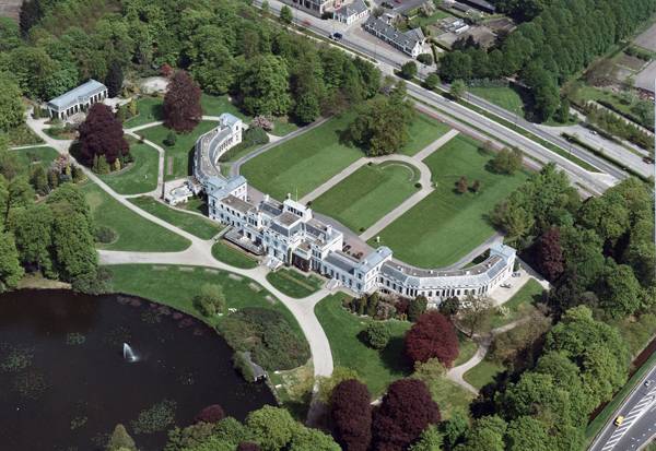
Aerial view Palace Soestdijk by Rijksvastgoedbedrijf
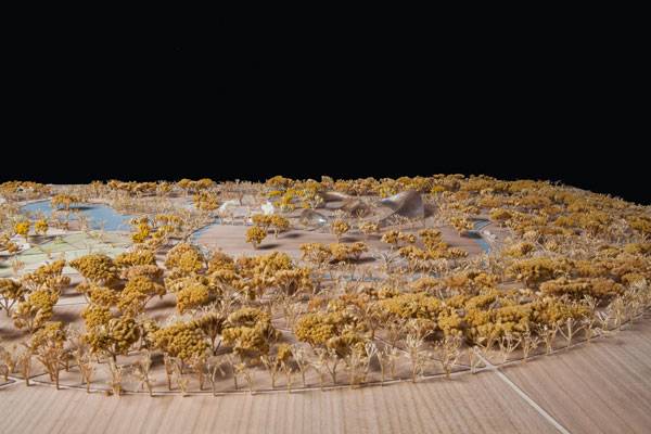
Eden Soestdijk
So, let’s discover what made this project a success in the competition.
Step 1 – Casting Problems What are the environmental problems we have worldwide? Population has increased, cities are crowded and disordered. Water, food, climate and energy have become problems instead of solutions. From this point, how can landscape architecture help through its design? The group of designers thought about each of these problems and how to put these complex troubles into a limited area, tackling them with solutions proposals and awareness. The group of designers thought about each of these problems and how to put these complex troubles into a limited area, tackling them with solutions proposals and awareness.
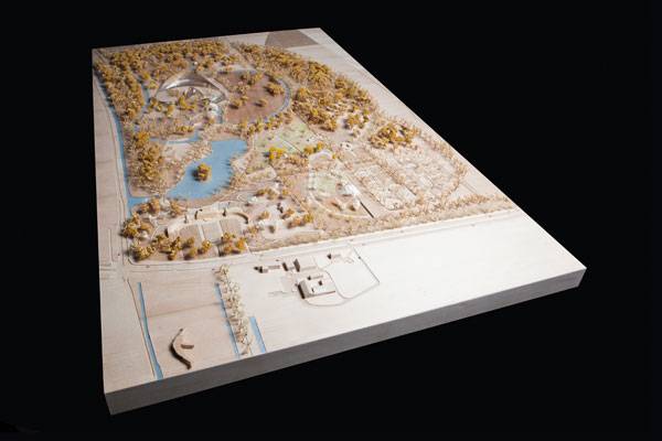
Eden Soestdijk. Image courtesy of Mecanoo
Eden Soestdijk. Image courtesy of Mecanoo
Eden Soestdijk. Image courtesy of Mecanoo
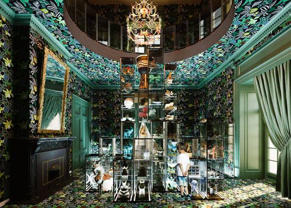
Step 4 – Preserve Historical Heritage and Bring About a New Design
“The Palace Soestdijk Estate is one of the most fairytale-like environments of the Netherlands: the ideal canvas for Eden Soestdijk. The royal family has always cherished the relationship with the surrounding landscape. The plan for Eden Soestdijk responds to this in a beautiful manner.” Says Francine Houben, creative director of Mecanoo Architecten. Part of Netherlands history and even European history itself passed through or happened in the surroundings of this site. So, the modern design of the project needed to talk to the past without leaving contemporaneity entirely. The palace architecture and its interior saves a rich history of the estate and Royal Family. Some of its chambers will be used for cultural and business events; an ideal place to exchange knowledge and mature ideas. Some multimedia presentations will stimulate the visitors’ imaginations while they interact with the displays that showcase the importance of Nature from scientific, historical and cultural perspectives, always focusing on awareness about the environment and sustainability.
Eden Soestdijk. Image courtesy of Mecanoo

Eden Soestdijk. Image courtesy of Mecanoo
Step 6 – Restoring the Gardens
Eden Soestdijk is within a big park surrounded by gardens and they make up part of this landscape. The gardens’ characteristics will be preserved and restored as they were in the glory times of the palace, maintaining the fairytale sensation of the backyards. The intention is to restore and also add some new educative elements through the landscape that allows an experience with Nature. Accessibility will mark this change, especially on sidewalks and paths encouraging public walking and cycling.
Inspire Your Ideas
Eden Soestdijk is inspired by the Eden Project in Cornwall, Great Britain. Inspiration motivates creativity. And the multidisciplinary group of designers worked for a common goal: design a landscape that could deliver a message of global importance. As it happens in Great Britain, they expect a large number of visitors annually, so the infrastructure must be well done. This is a perfect example of how to reach success in projects and proposals. Through all the inspiration, they created a futuristic place, joining historical heritage with the landscape and surroundings, and being original in their purposes. Tell us; what project excites your mind and inspired some project that you have made?
Eden Soestdijk. Image courtesy of Mecanoo
Full Project Credits For Eden Soestdijk :
Project Name: Eden Soestdijk Status: Ongoing Project Design: 2014 – 2016 Location: Amsterdamsestraatweg 1, Baarn, Netherlands Design Team: Mecanoo Architecten, Stichting Eden Soestdijk, Royal HaskoningDHV, Kossmann.dejong, Eden Project, Bouwhistorisch Onderzoek en RestaurTatie F. Franken. Client: Rijksvastgoedbedrijf Recommended Reading:

Dragon Lake Bridge Park | Establishing a New Waterfront District in Bengbu
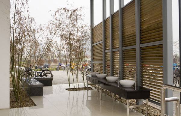
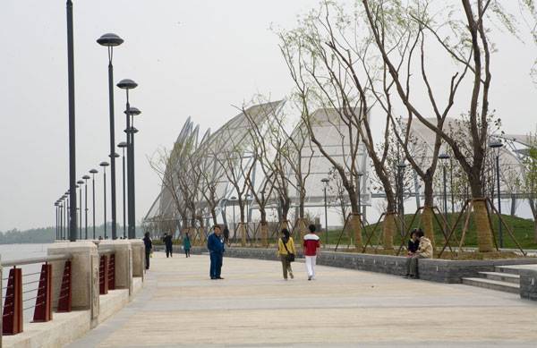
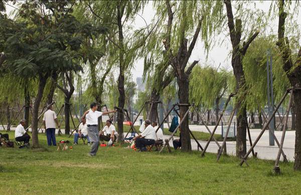
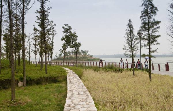
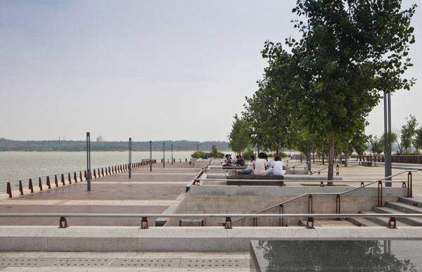
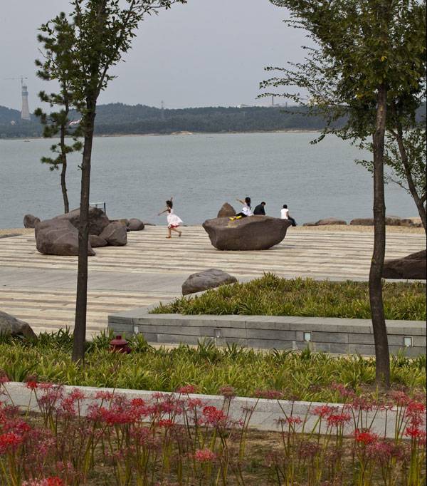
Article by Emily Sinclair – Dragon Lake Bridge Park, by AECOM, in Bengbu, Anhui Province, China The Dragon Lake Bridge Park, designed by AECOM designers Lee Yi and Lian Tao, in Bengbu, Anhui Province, China, is bringing the city back to its roots as a waterfront city. Bengbu is a mid-sized city in the Anhui Province of China with a population of nearly one million people. The Dragon Lake Bridge park lies in the centre of the city along one of the major lakes. The park, full of walkways and bridges, meanders along the bank of Dragon Lake, leaving many places for vistas and terraces to bring new views of the city and the water to those enjoying the park. Designed with gentle slopes and open pavilions, the waterfront has become a central destination for city-goers to enjoy at any time of day or night.
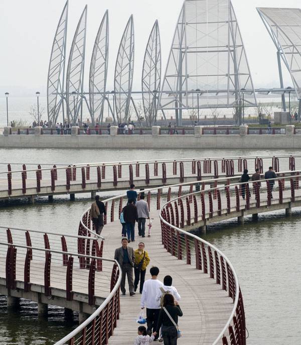
Dragon Lake Bridge Park. Photo credit: AECOM
Dragon Lake Bridge Park
Water from the Beginning
From the beginning of the design conception for this park, the history and culture of the surrounding Chinese landscape has been an important inspiration. The city’s connection to the water has been part of its identity since its inception. Even in name – ‘Bengbu’ in Chinese translates to ‘Clam Wharf’. With the Huai River and Dragon Lake nearby, the city grew as a center of the freshwater pearl industry.
Dragon Lake Bridge Park. Photo credit: AECOM
Dragon Lake Bridge Park. Photo credit: AECOM
Improving Water Quality
The city’s historic connection to water was important from the beginning, especially because of the polluted nature of the waters. The waters which once provided recreation and economic support to the locals had become dangerous with high levels of algae bloom. In order to return the waters of what is now known as Dragon Lake Bridge Park to healthy, normal levels, a variety of measures were implemented.
Dragon Lake Bridge Park. Photo credit: AECOM
Establishing a New Signature District
What would a new lakefront park be without city dwellers inhabiting it? Many areas for different programing are included in the design of this park. The simple materials with lighting subtly inset between rails and under steps make this a destination during the day and at night.
Dragon Lake Bridge Park. Photo credit: AECOM
Dragon Lake Bridge Park. Photo credit: AECOM
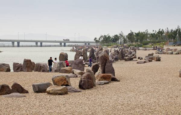
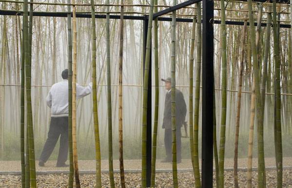
Plants and Local Identity
The planting scheme around the park is carefully chosen to reflect the surrounding natural landscape and situate the park within its regional context. The park spans 25 hectares in total, and throughout the park one can find numerous indigenous trees and native plants. Especially worth visiting is the Bamboo Garden and Celebration Plaza. This area, located at the center of the park, provides space for galleries, outdoor exhibitions, and sculptures while still maintaining a distinctly Chinese character.
Dragon Lake Bridge Park. Photo credit: AECOM
Dragon Lake Bridge Park. Photo credit: AECOM
Dragon Lake Bridge Park. Photo credit: AECOM
Full Project Credits For Dragon Lake Bridge Park :
Project Name: Dragon Lake Bridge Park Firm: AECOM, Los Angeles Location: Bengbu, Anhui Province, China Budget: 40 million Date of Construction: Completed May 2009 Size: 25 Hectare Awards: 2010 ULI Global Award for Excellence Client: Xincheng Comprehensive Development Zone Bengbu Recommended Reading:


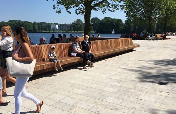
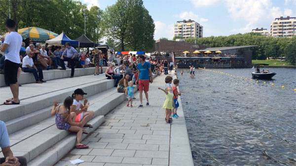
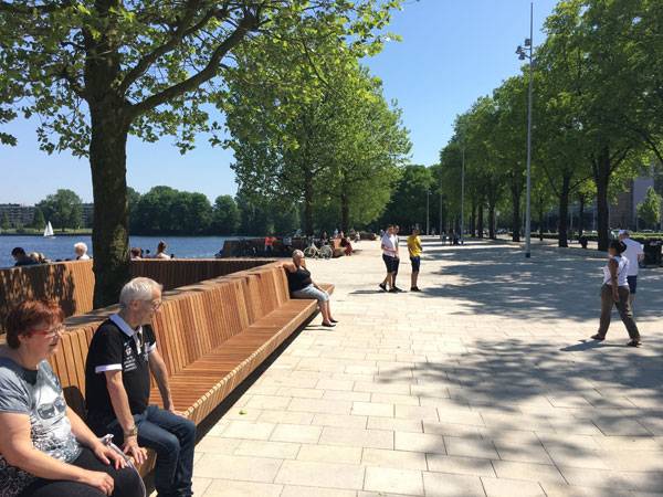
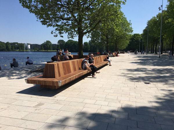
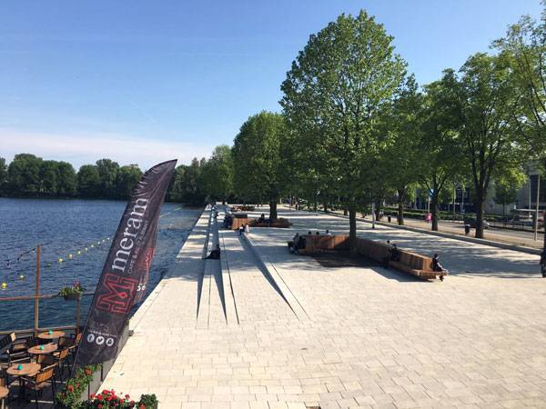
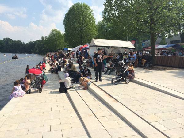
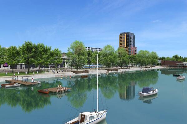
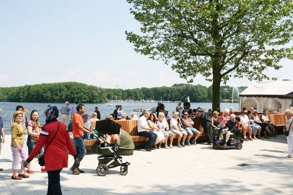
Zuidwestoever | How to Use Urban Furniture to Define a Space
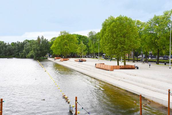
Article by Eleni Tsirintani – Zuidwestoever, by Guido Hermans: Stadsruimte, in Amsterdam, the Netherlands There are many ways to intervene into the landscape. It can be modified, reconstructed, handled, or simply maintained. The latter is also an intervention. Zuidwestoever design introduces all of the above in a single design gesture to create a new place for the citizens of Amsterdam where they can walk, sit, organize events or simply be next to the water. A new arrangement along the lakeside redefines the interaction with water, facilitates a number of new activities, and allows the citizens to enjoy a contemporary and high-quality public space.
Zuidwestoever. Photo credit: Stadsruimte BV
Zuidwestoever. Photo credit: Stadsruimte BV
Zuidwestoever
The intervention unravels along the edge of Sloterplas Lake. It is a linear boulevard; part of the Slotersplas Park facilities. Sloterplas is an artificial pond in the western suburbs of Amsterdam. Sloterplas Lake was shaped in 1935 and it was part of the General Expansion Plan for the area. The lake presents a variety of activities in water sports. There are a great number of facilities for sailing, canoeing, angling, and diving sports.
Zuidwestoever. Photo credit: Stadsruimte BV
Zuidwestoever. Photo credit: Stadsruimte BV
Zuidwestoever. Photo credit: Stadsruimte BV
Zuidwestoever. Photo credit: Stadsruimte BV
Zuidwestoever. Credit: Visualisatiekoning
Zuidwestoever. Photo credit: Grijsen
Zuidwestoever. Photo credit: Grijsen
Full Project Credits For Zuidwestoever :
Project Name: Zuidwestoever Location: Amsterdam, the Netherlands Date of Completion: October 2016 Design: Guido Hermans: Stadsruimte Caroline Elbers: Municipality of Amsterdam Patrick Grijsen, Grijsen Park & Straatdesign in collaboration with Eric Kruisselbrink, Idenova. Production of the Benches: Grijsen Park & Straatdesign Construction: JSB Infra. Recommended Reading:


Can Architecture Combat Air Pollution?
In this article, we look at how architecture can possibly combat air pollution and look at what the results of such solutions look like. For decades scientists, urban planners and multiple other disciplines have been looking for ways to reduce air pollution in cities. Lately we’ve seen smarter cars, more bicycle paths, innovative transportation methods, and a surplus of propaganda promoting the benefits of walking whenever possible. While all of these incentives have become part of the strategy to reduce smog in larger cities, architects may have found a better solution.
Can Architecture Combat Air Pollution?
The Manuel Gea Gonzalwz Hospital in Mexico City fights pollution by having a veil like structure coated with titanium dioxide which helps break down pollutants like nitrogen oxide. Essentially when the titanium dioxide is exposed to light, its electrons interact with water to release pollutant-busting free radicals. These radicals break down any pollutant particulate on the coated panels and attack airborne particles, too. What makes this pollution busting strategy unique is that the coating can be applied to a variety of surfaces. The Musee du Quai Branly in Paris tackles pollution with a living wall. The wall follows the properties of photosynthese meaning that is absorbs carbon dioxide while emitting oxygen. WATCH >>> 11 Insane Futuristic Architectural Designs
The greatest benefit to this approach is that it can be implemented in any part of the city to provide residents with better air-quality. Perhaps taking the green wall to a whole new level, Milan’s Bosco Verticale will be covered in approximately 730 trees, 11,000 ground-cover plants, and 5,000 shrubs. If you’re interested in reading more about this environmental initiative, read our article Forests in the Sky? While it’s currently only a concept, The Hyper Filter Skyscraper is tackling the threat of environmental pollution by not only inhaling carbon dioxide, pollutants and greenhouse gases but also exhaling concentrated oxygen. This process is achieved by the long pipe filters which ensure that the air is cleaned while the harmful substances are stored for use in the chemical industry. The Congress Gateway Towers in Chicago propose a complex air filtration system. The C02 is first adsorbed at the crown of the tower by carbon scrubbers and then by algae growing inside the building. The algae is then processed into biofuels to provide energy for the building residents’ clean vehicles. ________________________________________ Emily Matlovich is the writer for CADdetails’ blog Design Ideas for the Built World. The blog aims to inspire ideas for design professionals and is your source of information about the latest cutting edge projects, innovative product designs, and updates on industry trends. It is an extension of CADdetails which is the leading provider of manufacturer-specific building product information, delivering high quality planning documents to architects, engineers, contractors, and other design industry professionals throughout North America. Their mission is to help bring design projects to life by connecting the AEC industry with high-quality CAD drawings, 3D models, BIM files, specifications, images, projects and related documents from reputable manufacturers across the continent. All of their digital content is available for download free of charge. Recommended Reading:
- Becoming an Urban Planner: A Guide to Careers in Planning and Urban Design by Michael Bayer
- Sustainable Urbanism: Urban Design With Nature by Douglas Farrs
- eBooks by Landscape Architects Network
Featured image: shutterstock.com

Company Profile: Brummell Landscape Architects
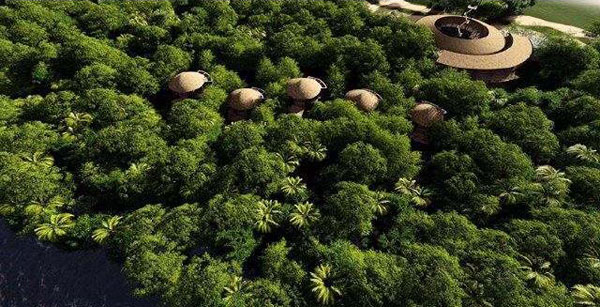
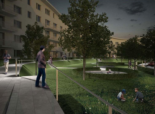
Landscape Architects Network Features a Company Profile of Brummell Landscape Architects. Brummell is among the leading landscape architecture firms in Germany. It is known for its national and international projects, not to mention its style and innovation. Some of the services offered in Brummell’s diverse portfolio include — but are not limited to — water gardens, waterscapes, water management, gardening, bio-engineering, urban concepts, hotel resorts, and roof gardens. What started as a simple vision to make places greener and more user-friendly has led to an entire network of landscape architects known collectively as Brummell, working on numerous projects both inside and outside of Germany. Brummell is the design team behind many successful urban parks and squares in Germany, as well as hotel resorts and green planning projects in Spain and Russia.
Brummell Landscape Architects
Brummell Landscape Architects
Currently, the company is known for its influence on many projects within Germany, including streets, residences, parks, and hotel refurbishments in Berlin and many similar projects in Dusseldorf, Frankfurt, Hamburg, and Munich that have been in place since 2014. Although the main offices are based in Berlin, Brummell has four other offices around the world: Bangkok, Frankfurt, Hangzhou, and Karlsruhe. Brummell is on the frontier of a new revolution in landscape architecture. The cornerstones were set 25 years ago, in 1992, by Andreas Brummell, the firm’s owner and CEO. The very first projects were mainly focused on industrial development and preservation projects in Germany.
Brummell Landscape Architects
A Philosophy That Tailors to the Modern Principles of Landscape Architecture
From Bangkok to Berlin and Hangzhou, Brummell’s design philosophy has spread to many corners of the world. The diversity of their landscape architects’ expertise can best be seen through their list of projects, including clinics, hotels, industrial development buildings, nursery schools, parks, private gardens, shopping centers, and squares.
Brummell Landscape Architects
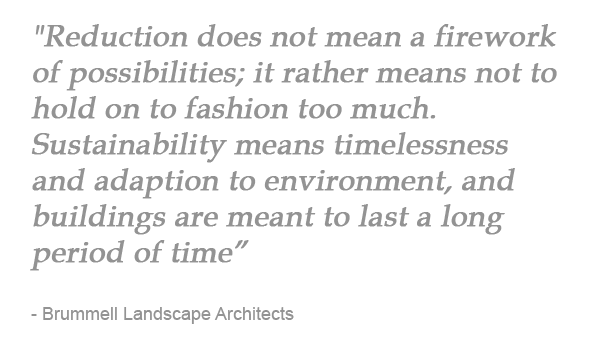 The fact that Brummell uses sustainable landscape materials is vital to the durability and unity of the arts and landscapes its landscape architects help create. They always strive to reduce the essentials, so that they make the most of the materials and forms and do not overuse anything. Another key value is the company’s approach to integrating nature in order to save resources and, at the same time, make modern spaces more adaptive to the natural environment, which in turn helps them last for long periods of time.
Specializing in Public, Private, and Commercial Projects in Many Parts of the World
Brummell’s reputation goes beyond the national borders of Germany. Its past and future projects in China, Thailand, and Europe are solid proof of this. Brummell specializes in three main fields of operation: private, public, and commercial projects. 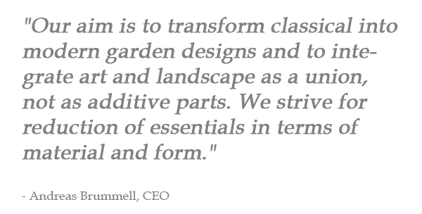 This way, the company promotes a universal approach toward integrating landscape architecture into today’s world and is able to help the environment as much as it helps people to enjoy parks, residences, streets, and urban areas in many corners of the world. Brummell is also known for many other types of projects, including golf courses (Russia), retirement homes (Germany), hotels (Klinikhotel in Berlin), and even sauna/bath projects. Brummell is a leader in various types of projects that aid the environment and make people feel more connected to nature while still breathing the urban air.
Brummell Landscape Architects
Influencing a Change in Urban Planning Around the World, One Project at a Time
With more than a dozen employees in its four main locations, Brummell continues to grow, project after project. Brummell’s clear vision and unique approach to landscape architecture is definitely changing the aspect of urban planning and our view on it, as well. Since 1992, Brummell has been changing the world. What was once a new frontier in landscape architecture is now a company that has a profound role in the reconstitution of meaning and value in the community today — and one that influences all aspects of environmental development.
Direct Information for Brummell Landscape Architects:
Office Name: Brummell Landschaftsarchitekten International Founder: Andreas Brummell Year of Foundation and Location: Founded in Germany in 1990 Office Locations: Bangkok/ Berlin / Frankfurt / Karlsruhe Niebuhrstrasse 4 – 10629 Berlin Website: http://www.brummell.de E-mail contacts: info@brummell.de Social Networks: Facebook, LinkedIn Some of the most important public realm projects designed by Brummell Landscape Architects include:
- Mommsenstrasse, Berlin
- School Blücherschule, Wiesbaden
- Residence Gartenstrasse, Oranienburg
- DRK clinic Berlin
- Tarabya outside facilities, Turkey
- Fire Station, Potsdam
- German Consulate outside facilities, Jeddah
- Farmyard “Paulinenhof” Stuttgart
- Engine shed complex, Dillingen
The private projects that the landscape architects at Brummell Landscape Architects pride themselves on include:
- Premises “Höwing”, Berlin
- Villa Werderstrasse, Baden Baden
- Roof terrace Panton, Mallorca
- Premises “Bliss”, Karlsruhe
- Premises “Taylor, East Grinstead”, England
- Premises “O’Connell, Burges Hill”, England
- Premises “Mauffrey, Saverne”, France
- Premises “Hugger, Hagenau”, Frankreich
- Premises “Duus”, Karlsruhe
Lastly, the commercial projects are the ones that include malls and hotel terraces, such as:
- Viva City Adlershof
- Student Residence in Gotthardstraße, Berlin
- Daimler Benz Projekt Potsdamer Platz, Berlin
- Hotel terrace in Stresemannstrasse, Berlin
- Wildau
- PX Shopping Center Hainerberg
- Lehmbruck Street Berlin
- Renneroder Street Frankfurt
- City field Wernigerode
If you would like to get your landscape architecture office profiled on Landscape Architects Network, contact us at office@landarchs.com Profile composed by Frank Bourque


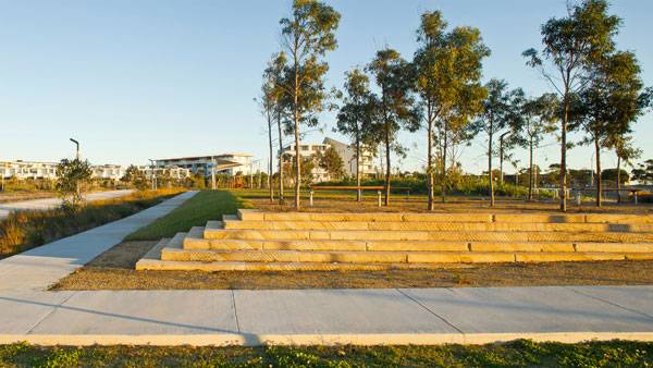
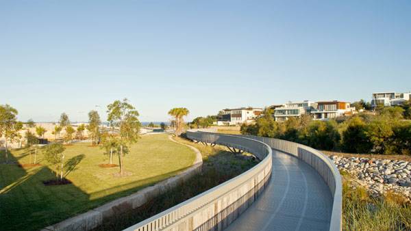
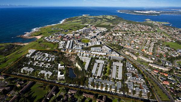
Little Bay Cove | A Big Ecological Endeavor
Article by Gwgw Kalligiannaki – Little Bay Cove, by McGregor Coxall, in Little Bay, Sydney, Australia. Designed with the principles of “urban ecology”, the Little Bay Cove is an excellent example in which “the experience of the landscape has been carefully considered to support a diversity of spaces that provide a range of amenity”, as McGregor Coxall says of his project. His proposal is based on a grid, where housing typologies are placed. A water-sensitive design basis is incorporated into the central ecological corridor and public park, but also the streets themselves.
Little Bay Cove. Photo credit: E Little Bay
Little Bay Cove
Coxall’s design is based on reuse of the site’s materials and local plants, to ensure absolute sensitivity towards the local topography. As landscape architects analyze, plan, design, manage, and nurture the built and natural environments, they work to create outdoor places, in order to maintaining the balance between the built and natural environment in our cities. They design innovative spaces and improve environmental quality in order to produce “human spaces”. Many landscape projects are influenced by the key points of “urban ecology”; providing spaces designed to respect and highlight the locality of the landscape, inculding “social, environmental, and ecological systems”.
Little Bay Cove. Photo credit: Simon Wood
Creating a New Masterplan
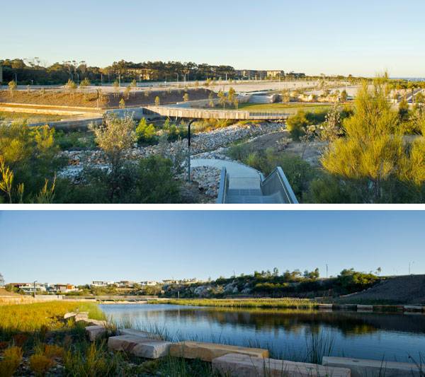
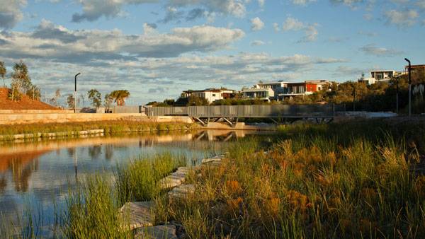
As the former buildings and services, as the UNSW sports fields or the UNSW Biological Resources Center, were scattered across the site, the design team decided to demolish all existing buildings, and redesign the landscape. The new master plan includes two public parks, the Urban Lounge and the Brand Park. The streets are organized according to the Water Sensitive Urban Design principles. Also, all the pedestrian connections around the site were enhanced to connect the new master plan to the existing city grid.
Little Bay Cove. Photo credit: Simon Wood
Design Strategy
Coxall’s design is based on three main principles; water sensitive design, endemic plant material use, and ecologically responsible design. Paying attention to those principles, the design strategy is based on rigorous site analysis with Australian standards and codes. Also, the brief indicates a stormwater system to detain and clean stormwater.
Little Bay Cove. Photo credit: Simon Wood
Organizing the Site
The public open space provides a new street grid, which connects the site with its public environment and is based on water sensitive urban design initiatives. The street typology consists of avenues, green streets, raingarden streets, urban lounge access ways, lanes, and pedestrian links.
Little Bay Cove. Photo credit: Simon Wood
Little Bay Cove. Photo credit: Simon Wood
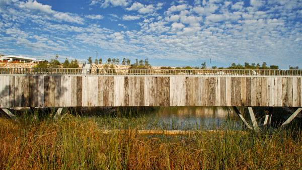
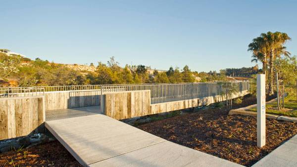
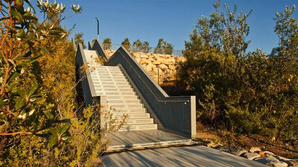
Wandering in the Landscape
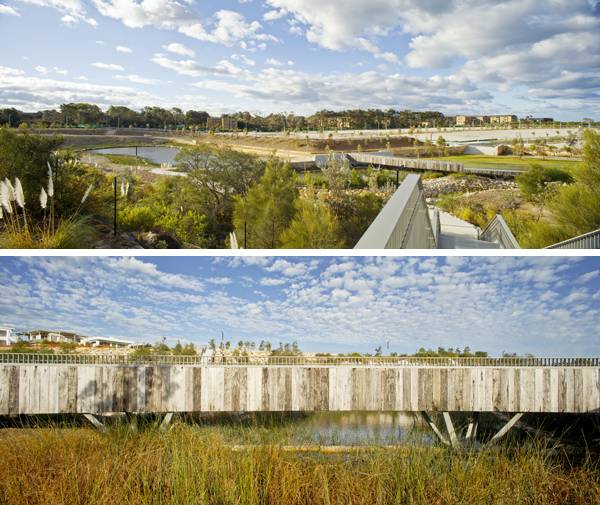
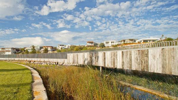
The pedestrian network was formed to connect the site with the city, but also to give space for walking, jogging and play areas. The snake-form steel bridge, the steel stairways and weir-top bridge provide pedestrian access across the site bringing guests close to all of the site’s spaces, even over the water.
Little Bay Cove. Photo credit: Simon Wood
Little Bay Cove. Photo credit: Simon Wood
Respecting the Remnants
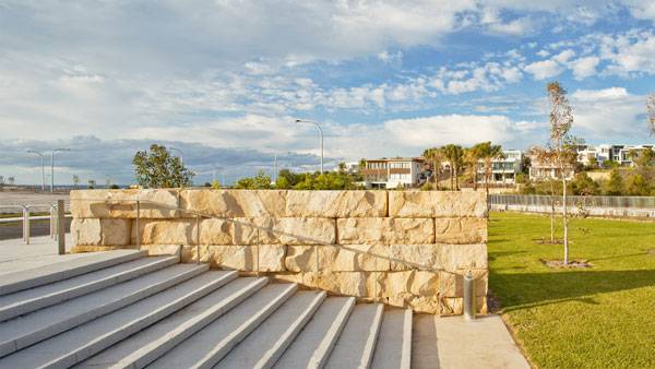
Unlike the former buildings, Coxall proposed to retain and protect the Eastern Suburbs Banksia Scrub and the Miocene and Ochre deposits. Interpretive signage was provided to inform the guests about the history of the site, the Eastern Suburbs Banksia Scrub and the Miocene. It is really important when we redesign spaces that have some history, to keep former elements that show the previous character of the site and its connection to the present. Coxall promoted the using of salvaged and recycled materials in the site’s areas, reinforcing that remnants are not treated only as historical evidence, but can also used in the context of eco-design.
Little Bay Cove. Photo credit: Simon Wood
Planting
A strong gesture from the architect is the use of native plants on the site. The indigenous planting limits help the new design to relink to the existing topography, and link the site to the remnant patch of the Eastern Suburbs Banksia Scrub. In Coxall’s design, planting is used to promote privacy between the site and the “neighbors”, but also to create shade areas. The Casuarina planting on the northern boundary was also retained and reinforced with native plants. The re-generation of the Central Corridor is used to foster the creation of native ecosystems and promote urban biodiversity. A lot of the existing native trees were retained within the “urban ecology”. This new design gives Little Bay Cove a new, vital character as a public space, which provides communication between the users.
Little Bay Cove. Photo credit: Simon Wood
Little Bay Cove. Photo credit: TA Little Bay
Full Project Credits For Little Bay Cove:
Project: Little Bay Cove Location: Little Bay, Sydney, Australia Total Site Area: 13.6 ha Client: Charter Hall Group, TA Global Year: 2014 Budget: $7,000,000 Collaborators: Charter Hall Group Hill Thalis Architects + Urban Projects Candalepas Associates Steensen Varming Paragon Project Management CIP Commercial & Industrial Property Pty Ltd Worley Parsons Aecom Robert Bird Group Steve Paul and Partners Norman Disney & Young AHMS Denny Linker & Co Travers Bushfire & Ecology Charter Hall Group Recommended Reading:
- Becoming an Urban Planner: A Guide to Careers in Planning and Urban Design by Michael Bayer
- Sustainable Urbanism: Urban Design With Nature by Douglas Farrs
- eBooks by Landscape Architects Network

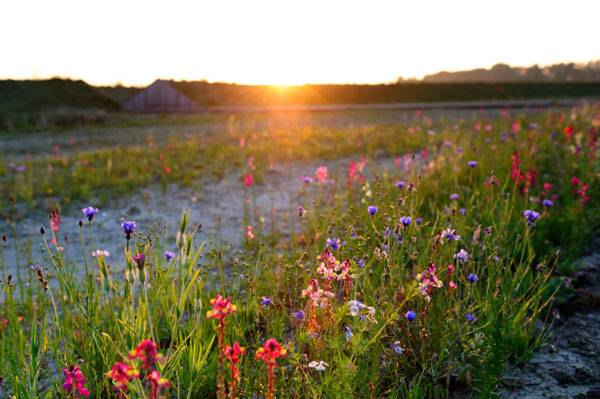
Land Art Park Buitenschot | Can a Landscape Design Cut Out Noise Pollution?
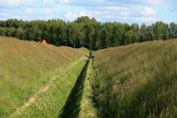
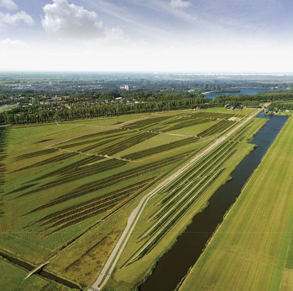
Article by Amrita Slatch – Land Art Park Buitenschot, by H+N+S Landscape Architects, in Hoofddorp, the Netherlands When you land at Amsterdam’s Schiphol Airport, you might not notice the 80-acre, diamond-shaped green space right next to one of the runways. But that’s OK. That is not the purpose of this green space. Instead, it is meant to solve one of the most basic issues faced by residential areas near airports: ground noise. The idea to deflect low-frequency noise caused by aircraft taking off from one of the busiest airports in the world is an amazing attempt at using the nature of plants to absorb sound. It’s a project that doesn’t just aim to beautify the open space with landscaping, but to technically mold the space to solve a much bigger problem. Let’s learn how H+N+S Landscape Architects managed to pull of this multidisciplinary project.
Land Art Park Buitenschot. Photo credit: Paul de Kort
Land Art Park Buitenschot
Researching Noise-reducing Landscape
After the airport’s fifth runway (Polderbaan) was built, the ground noise near the adjacent residential area of Hoofddorp increased to such an extent that mitigating measures were required. Over the span of some time, residents noticed that the ground noise was largely reduced when farmlands were plowed. This became a gateway into understanding and researching noise-reducing landscape.
Land Art Park Buitenschot. Photo credit: Your Captain Luchtfotografie
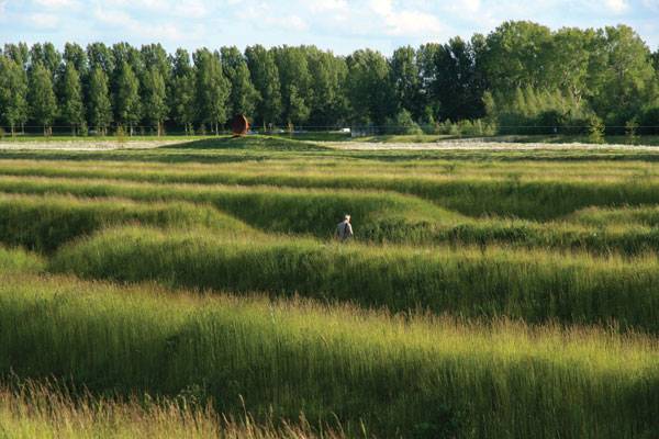
The Iterative Process
The undulations formed on farmlands after plowing helped in sound dispersion, which further helped reduce noise. After understanding this, a team of people — including H+N+S, visual artist Paul de Kort, TNO (a noise-reduction technology company) and Witteveen + Bos (cost calculation and feasibility) — conceptualized the idea of a ridged landscape near the runway. Under the supervision of the Government Service for Sustainable Rural Development, Mainport and Groen Foundation, and Amsterdam Schiphol Airport, a maze-like park was designed, drawing from the 17th-century experiments in acoustics by German scientist Ernst Chladni, known as the “father of acoustics.”
Land Art Park Buitenschot. Photo credit: Marleen Bos
The Landscape that Diminishes Noise
Having realized the importance of ridges and how they help in deflecting noise, the team designed three-meter-high embankments that were carved onto the land surface. It is important to recognize that the three-meter value was generated after a lot of measurement and calculations on how oblique planes help to distort and disperse ground noise.
Land Art Park Buitenschot. Photo credit: Marleen Bos

Land Art Park Buitenschot. Photo credit: Marleen Bos
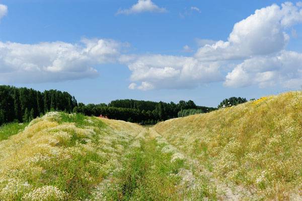
The Landscape that Stimulates Wandering, Fun, and Recreation
The beauty of this project lies in the fact that the embankments are designed so that they very seamlessly blend into the existing landscape. The reason for this is that the in-between spaces between two raised embankments have been converted into one-meter-wide walkways.
Land Art Park Buitenschot. Photo credit: Marleen Bos
Land Art Park Buitenschot. Photo credit: Paul de Kort
Something Much More than Just Land Art
A land art project — and at the same time Europe’s largest maze — has singlehandedly integrated the disciplines of landscape architecture and acoustic technology. According to the Works that Work, the park reduces the ground noise by two to three decibels. Although that is less than what was expected, which was eight to 10 decibels, the Amsterdam Schiphol Airport hopes to work on that in the future. Looking at Land Art Park Buitenschot as an example, the Melbourne Airport and London’s Gatwick Airport are adopting similar measures as natural ways to curb ground noise. A form that was agriculturally inspired seems to have been able to answer the questions regarding noise reduction and recreation. The result of Land Art Park Buitenschot is a multidisciplinary project that has made the residents of Hoofddorp less burdened by ground noise and able to live a more comfortable life. Have the designers been successful in their efforts to solve the noise pollution problem? Do you think this type of work can achieve more positive results? Should such noise-reducing landscapes be made compulsory near airports? Answer with your comments below.
Full Project Credits For Land Art Park Buitenschot:
Project Name: Land Art Park Buitenschot Location: Hoofddorp, the Netherlands Budget: € 830,000/ha Date of Construction: 2014 Size: 36,000 square meters Awards: Finalist for the Rosa Barba Prize Client: Schiphol, in collaboration with Stichting Mainport en Groen Designed By: H+N+S Landscape Architects Collaborators: Paul de Kort, artist landart; Witteveen + Bos, engineering company; Nijmeijer en Mokking environmental consultancy, environmental experts; TNO, independent research organization Recommended Reading:
- Becoming an Urban Planner: A Guide to Careers in Planning and Urban Design by Michael Bayer
- Sustainable Urbanism: Urban Design With Nature by Douglas Fa


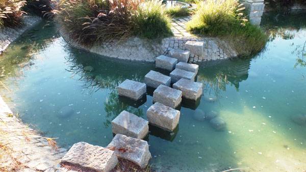
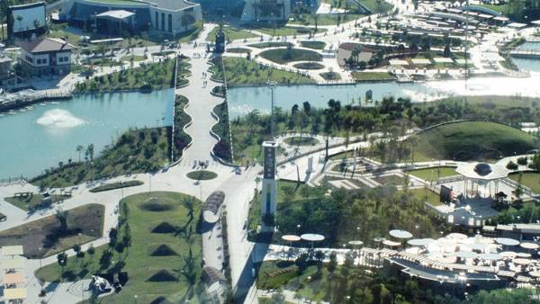
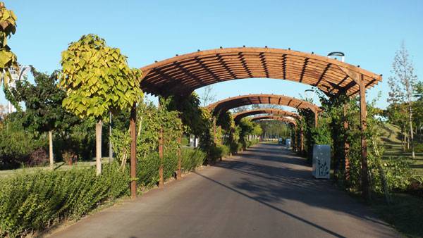
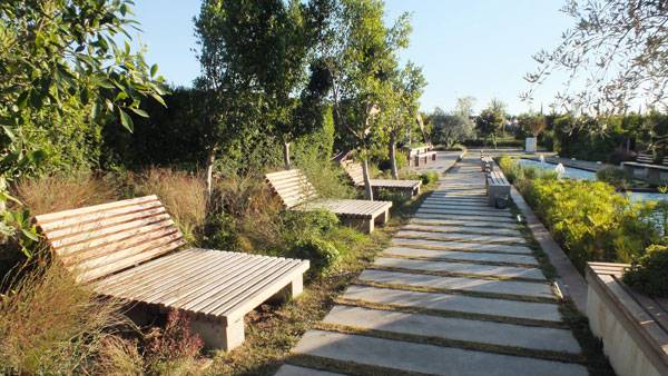
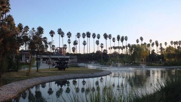
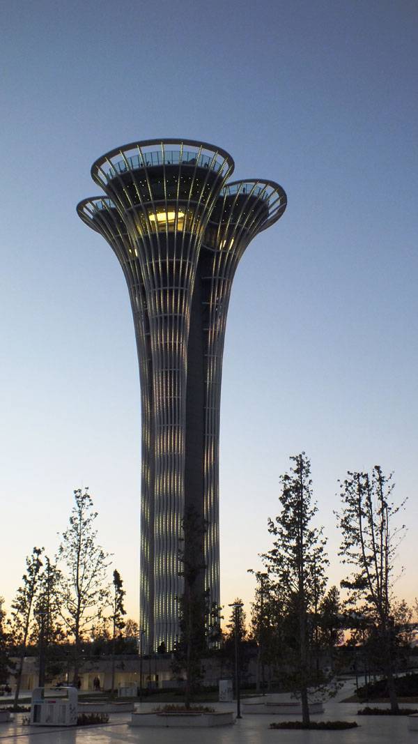
How did EXPO Antalya 2016 Express its Theme of Flowers & Children?
Article by Irmak Bilir – Expo Antalya 2016 by Artı Architecture Engineering Consulting, in Antalya, Turkey. It’s sure thing that a botanic expo must give a significant point to flowers, and at the same time, if an exposition’s philosophy is “A Green Life for Future Generations”, it is a must to include “Children” in its theme. Botanic EXPO Antalya 2016, which is designed by Artı Architecture Engineering Consulting, bears the theme “Flowers and Children” with its slogan, Cultivating the Future.
Expo Antalya 2016. Photo credit: Irmak Bilir
Expo Antalya 2016. Photo credit: Irmak Bilir
Expo Antalya 2016
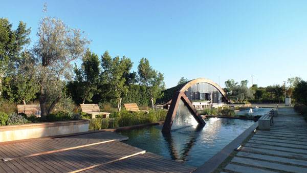
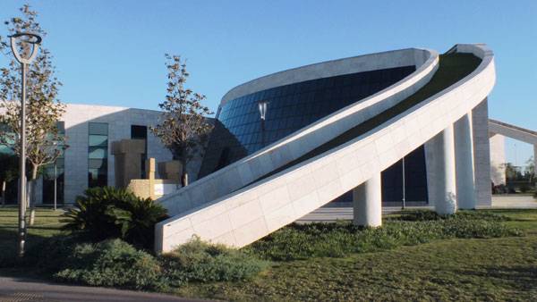
EXPO Antalya’s opening ceremony was held on the 23rd of April 2016, on the National Sovereignty and Children’s Holiday which was dedicated to all the world’s children by Atatürk, the founder and greatest leader of the Turkish Republic, in 1923. It was a nice beginning for a “Flowers and Children”-themed exposition. A big manmade lake lies down in the exposition area and there is an island and a semicirclular structure which is called “Children Island”.
Expo Antalya 2016. Photo credit: Irmak Bilir
Expo Antalya 2016. Photo credit: Irmak Bilir
Expo Antalya 2016. Photo credit: Irmak Bilir
Expo Antalya 2016. Photo credit: Irmak Bilir
Flora
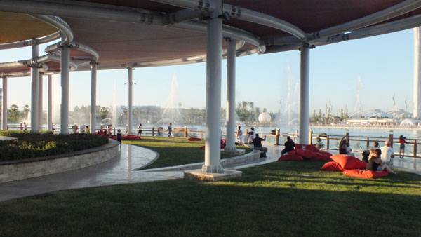
The area around Antalya is extremely fertile and has an enormous variety of plant species. There are 750 endemic species in the area. What a good place to arrange a botanic EXPO! There are indoor gardens, a cactus garden, an agriculture and biodiversity museum, Turkey Biodiversity Trail, EXPO Greenhouse, EXPO Forest, an aquatic plants garden, medicinal and aromatic herbs garden, institutional and university gardens. And moreover, a peony terrace, which is next to the lake and allows watching of the musical water fountain dance shows.
Expo Antalya 2016. Photo credit: Irmak Bilir
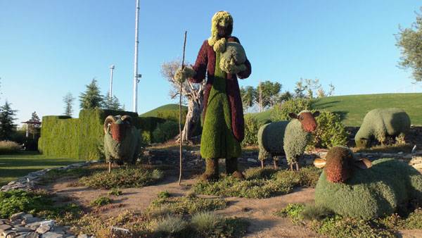
Live Plant Sculpture Exhibition Area
One of the most fantastic parts of the EXPO is the giant live plant sculptures which spread around a large area and tell their stories with their magnificence. The plant sculpture project belongs to a Canadian firm Mosaicultures Internationales De Montreal and it is the largest plant sculpture site worldwide. For the 108-plant sculpture, it was planned that they would use 700,000 plants.
Expo Antalya 2016. Photo credit: Irmak Bilir
Expo Antalya 2016. Photo credit: Irmak Bilir
Expo Antalya 2016. Photo credit: Irmak Bilir
Expo Antalya 2016. Photo credit: Irmak Bilir
Expo Antalya 2016. Photo credit: Irmak Bilir
Full Project Credits For Expo Antalya 2016:
Project Name: Expo Antalya 2016 Location: Antalya, Turkey Area: 1121 decar Cost: 1.6 billion Turkish Liras Landscape Architecture: Artı Architecture Engineering Consulting Employer: Expo Antalya Agency Project Year: 2016 Recommended Reading:
- Becoming an Urban Planner: A Guide to Careers in Planning and Urban Design by Michael Bayer
- Sustainable Urbanism: Urban Design With Nature by Douglas Fa
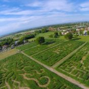

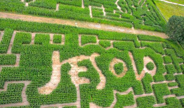
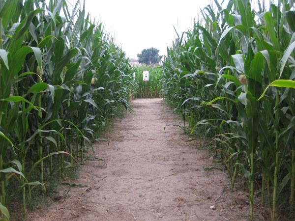
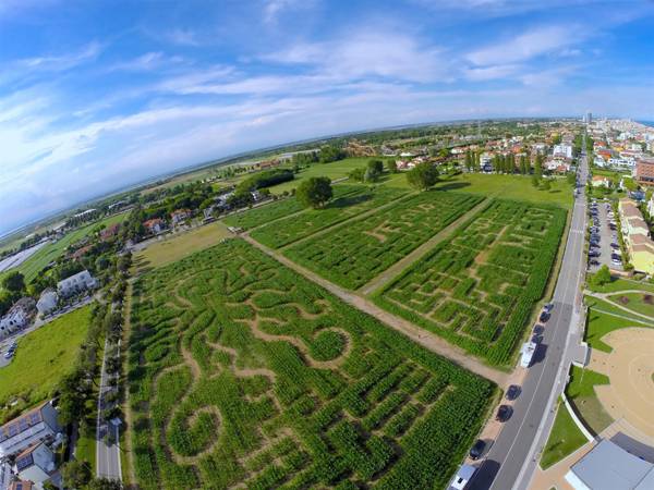
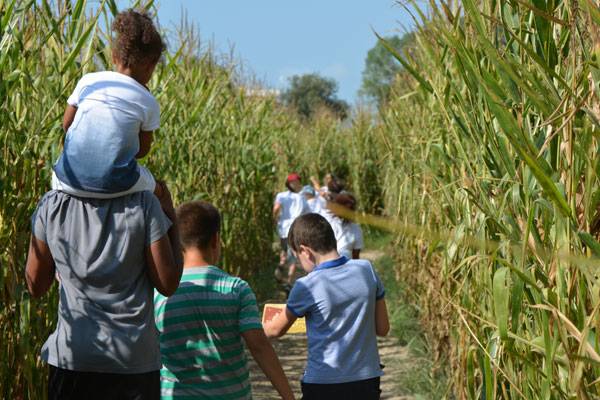
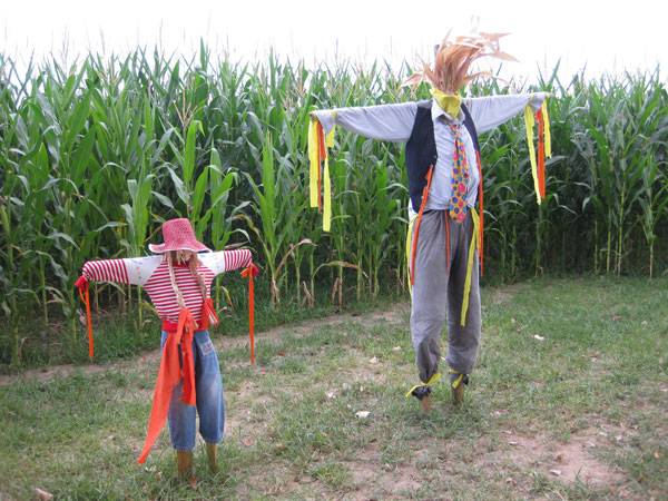
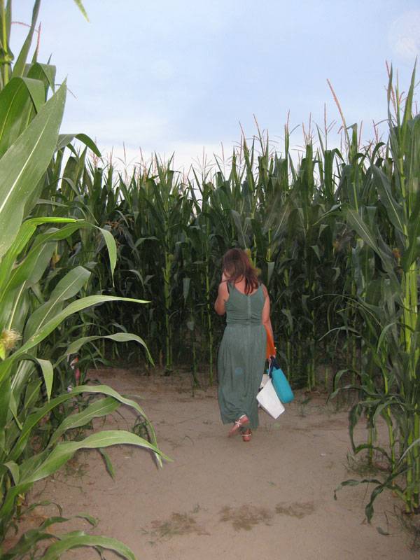
LeMessi Labirinto di Jesolo | A Temporary Open Air Maze
Article by Anja Graner – LeMessi Labirinto di Jesolo, by Flavia Pastò, landscape architect, in Jesolo, Venice, Italy. In 2015, a unique and innovative attraction was initiated in Jesolo, a metropolitan town in Venice, Italy. It was LeMESSI, the corn maze, which attracted visitors of all ages and nationalities to test themselves on 6 kilometers of trails. The designers upped the ante in 2016, creating five different mazes with increasing levels of difficulty over an area of 50,000 square meters. The maze played an unusual role of connecting open air entertainment with the dynamic of local agriculture. Natural rhythms met the seasonality of the corn plant, whose cultivation is widespread in this region. Visitors and locals were able to experience a sustainable and affordable playground. This one location provided many adventures. Visitors could immerse themselves in the magical atmosphere and join in on theme nights with special entertainment.
LeMessi Labirinto di Jesolo. Photo credit: Flavia Pastò
LeMessi Labirinto di Jesolo
The corn maze emerged in collaboration with local designer Martino Messi and the American company “The MaiZe”. During a trip to the United States, Messi discovered “The MAiZE”, the largest maze consulting company in the world, specializing in designing and creating corn mazes. Fascinated by the idea and the designs, Messi decided to bring the attraction to the seaside town of Jesolo, which is characterized by seasonal tourism and agriculture. In 2016, the Italian landscape architect Flavia Pastò joined and designed the floor plan of the corn maze. Following the agricultural calendar, every year in April nearly 500,000 corn kernels are sown, and the maze plants grow during the months leading up to summer. In May, when the plants reach a height of about 50 centimeters, the trimming of the pathways processes according to a previously drawn map on the computer. The footpaths that spread over the area make up the whole maze, and the complete design is only visible from above.
LeMessi Labirinto di Jesolo. Photo credit: Flavia Pastò
LeMessi Labirinto di Jesolo. Photo credit: Flavia Pastò
LeMessi Labirinto di Jesolo. Photo credit: Flavia Pastò
LeMessi Labirinto di Jesolo. Photo credit: Flavia Pastò
LeMessi Labirinto di Jesolo. Photo credit: Flavia Pastò

LeMessi Labirinto di Jesolo. Photo credit: Flavia Pastò
Full Project Credits For LeMessi Labirinto di Jesolo:
Project: LeMessi Labirinto di Jesolo Location: Jesolo (VE) Designer: arch. Flavia Pastò, Landscape architect Costumer: CA’ Verde srl, with the sponsorship of Jesolo City Tourism department Timeline: April 2016_ Corn planting May 2016_ Cut of Path June 2016_ Opening September 2016_ Closing and threshing Area: 52.300mq the total area (with service, bar, parking) 50.000mq the Labyrinth area 462.500 grain of wheat 6 km of path 5 Labyrinths with different difficulty Cost: € 25000 Image credit: Flavia Pastò Recommended Reading:
- Becoming an Urban Planner: A Guide to Careers in Planning and Urban Design by Michael Bayer
- Sustainable Urbanism: Urban Design With Nature by Douglas Fa