


Author: Land8: Landscape Architects Network


How New Urbanization Can Help People Live Better Lives
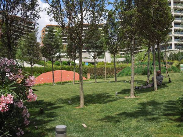
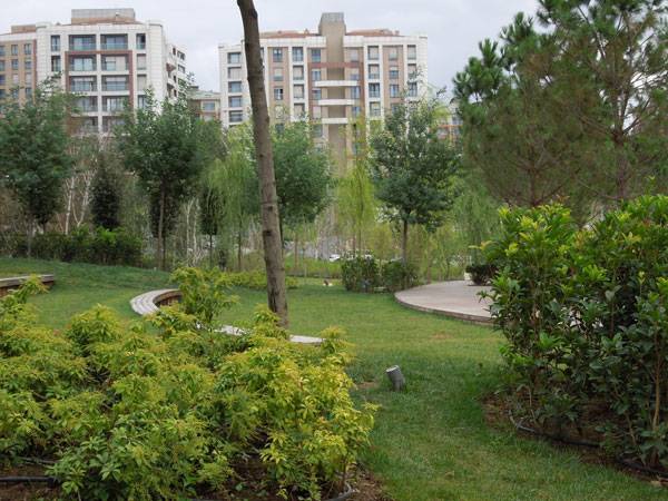
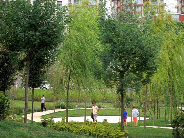
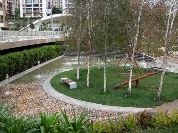
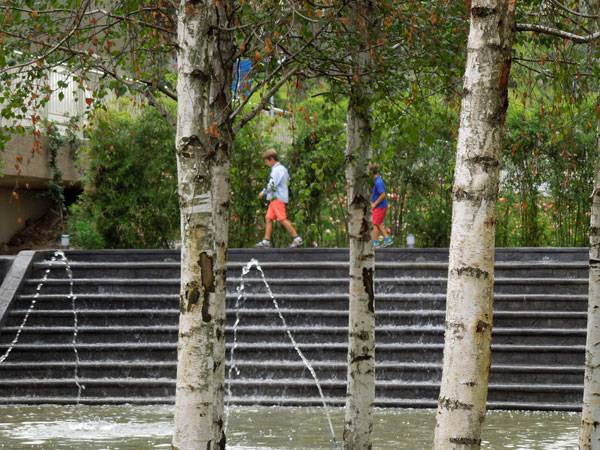
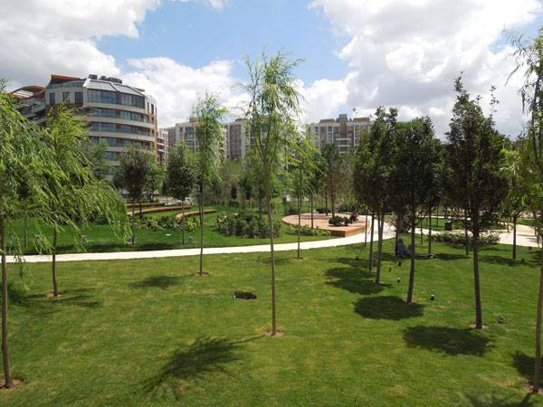
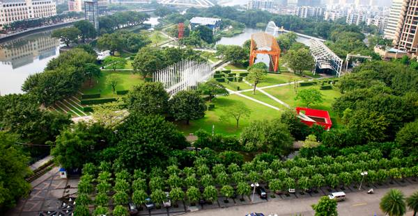
Akasya Acibadem Central Park, by SdARCH Trivelli & Associati & Alhadeff Architects, Istanbul, Turkey. As Istanbul is considered by many to be one of the best capitals of art and culture, parks in the city are just as spectacular and in the following project lies the evidence: Akasya Acibadem Central Park located in Acibadem district. An area of high quality housing projects in the Asian side of Istanbul. In recent years, a new road network and new residential buildings came up. This Park appears to be the green center or the “green lung” of this new urbanization. The park surrounds the new shopping mall in Akasya, designed by DDG Architects. WATCH: Akasya Master Plan by DDG Architects The landscaping team, standing behind the “green lung”, is SdARCH Trivelli & Associati. They teamed up with Alhadeff Architects. Through their project they have managed to transform a former factory site into an outstanding scene. A dramatic change, calling for a peep behind the scenes of Akasya Acibadem Central Park.
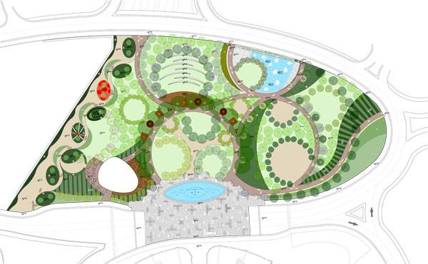
Master plan. Credit: SdARCH Trivelli & Associati
New Urbanization Forming a United Whole
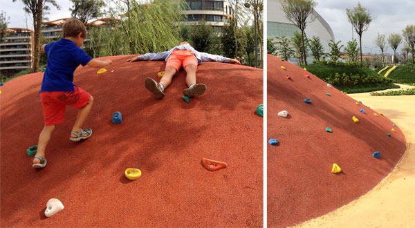
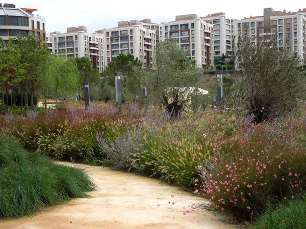
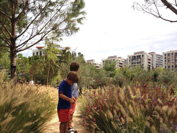
The designed landscape public space is situated in front of the main entrance of the mall. The 2.2-acre park enclosed by new shops and restaurants, a ring of roads and pedestrian paths making for a centralized location. Akasya Central Park unites the site. Providing circulation and a gradual transition between residential areas and the commercial center. The “united whole” achieved through the landscape design uses elliptical and oval shapes, reflecting the same rounded lines of the entire project.
Credit: SdARCH Trivelli & Associati
Credit: SdARCH Trivelli & Associati
Credit: SdARCH Trivelli & Associati

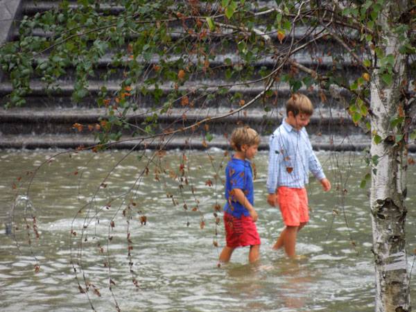
Open air theatre. Credit: SdARCH Trivelli & Associati
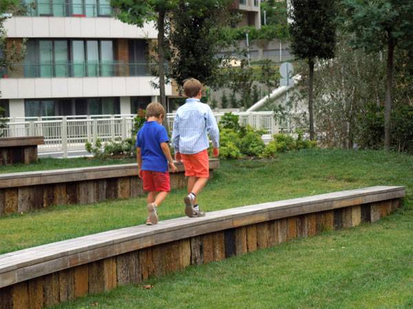
Children making their way around the park. Credit: SdARCH Trivelli & Associati
Credit: SdARCH Trivelli & Associati
- Pocket Parks: Why size doesn’t matter
- The Flying Parks- From The Highline in New York to The Promenade Plantée in Paris!
- An Underground Park – The Lowline Park
Credit: SdARCH Trivelli & Associati
Credit: SdARCH Trivelli & Associati

Credit: SdARCH Trivelli & Associati
Credit: SdARCH Trivelli & Associati
Credit: SdARCH Trivelli & Associati
Credit: SdARCH Trivelli & Associati
Credit: SdARCH Trivelli & Associati
- 1000 Details in Landscape Architecture: A Selection of the World’s Most Interesting Landscaping Elements by Francesc Mola
- Street Design: The Secret to Great Cities and Towns by John Massengale
Article by Velislava Valcheva Return to Homepage

How to Transform a Road into a Spectacular Park
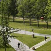
Mekel Park, by Mecanoo in Delft, the Netherlands. The Delft University of Technology (TU Delft), one of the most prestigious of its kind in the Netherlands, aimed in 2004 to transform the busy and broad Mekel Road, which splits the campus in half, into a spectacular park. The goal was to bring to the campus the high quality of life in the city of Delft. Located in the heart of the campus, the park bridges the buildings of all the faculties and, because of this, it symbolizes the university’s international and interdisciplinary character, bringing together in a pleasant way people with different cultural and academic backgrounds.
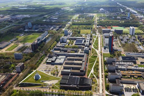
Image credit: www.mecanoo.nl
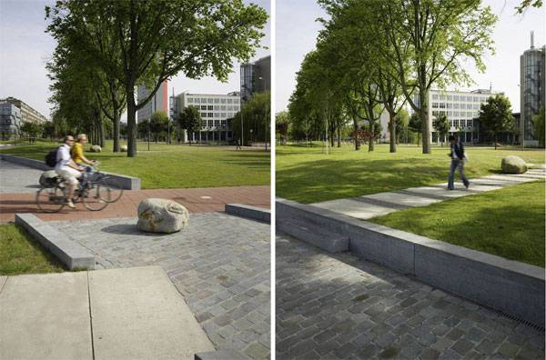
Image credit: www.mecanoo.nl
Road Transformed into a Spectacular Park
The Mekelweg (Mekel way), a broad and noisy road surrounded by vast parking lots that used to run through the middle of campus, has been transformed by this project into a lush park with colorful trees. The Mekel Park, covering 6.4 hectares, is bordered on one side by an esplanade called the Nieuwe Delft (The New Delft), which connects the pedestrian promenade, faculty buildings, and lounge areas.
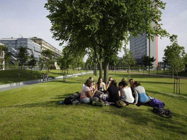
Image credit: www.mecanoo.nl
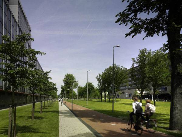
Image credit: www.mecanoo.nl
- Car Park Turns into Public Park!
- Private Estate Reveals State of The Art Underground Car Park
- The Dark Secrets Behind Sustainable Urban Design Revealed in Şışhane Park
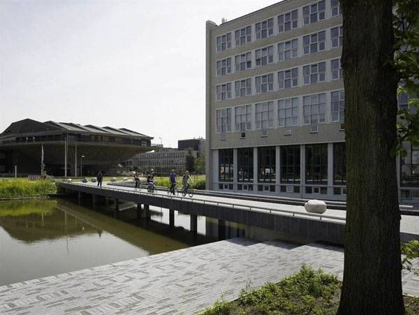
Image credit: www.mecanoo.nl
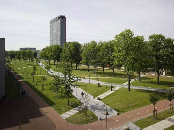
Image credit: www.mecanoo.nl
- Landscape Architecture Now! by Philip Jodidio
- Street Design: The Secret to Great Cities and Towns by John Massengale
Article by Diana Ispas Return to Homepage

Sketchy Saturday |032
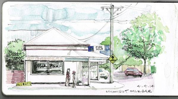
This week’s Sketchy Saturday top 10. Welcome to this week’s exciting edition of Sketchy Saturday. This week’s sketches may have been the toughest in our Sketchy Saturday history to judge the top 10. There is a fine line between what is excellent work and what is suitable for Sketchy Saturday. With Sketchy Saturday we always stretch the definition of the word sketch and display some questionable entries, but we’re always searching for a high raw element to the work and a direct relevance to landscape architecture. Enjoy this week’s Sketchy Saturday top 10! 10. by Luna Refaie , (Architect) , Jordan

Luna Refaie
Sahra Stolz
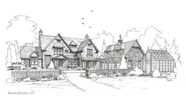
Devin S. Kimmel
Elina Richert
Morozova Lada
Jacek Gonera
- Freehand Drawing & Discovery by James Richards | Book Review
- How to Suck at Hand Drawings and Still be a Good Landscape Architect
- Interested But Not Confident? – Know How to be Good at Hand Drawings
3. by Tino Beck, self-employed artist, Germany
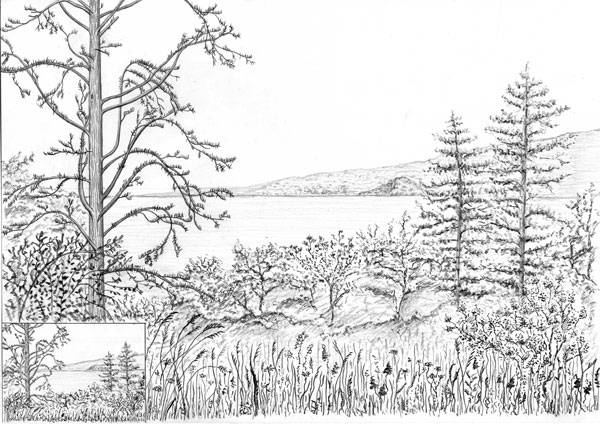
Tino Beck
Jerome K Benhur
Gustavo Garrido
- Sketching from the Imagination: An Insight into Creative Drawing by 3DTotal
- Architectural Drawing Course by Mo Zell
Article written by Scott D. Renwick Return to Homepage
Interested But Not Confident? – Know How to be Good at Hand Drawings
A-Z guideline to a successful hand drawn design. Design is a process that starts right inside the designer’s mind and the soul. Then it comes out in different physical forms by the help of different media. Though the use of software in the design process is getting popular, still we all know and believe that hand drawn pieces in the initial design state is like nothing else. When it comes to translate the creative person’s mind and soul, what can be greater than the hands doing a sketch on paper? The initial sketches are always the pure documentations of the designer’s idea. Also detailed sketches are of added value in the final presentation as well. To be successful in hand drawings some easy and nice primary techniques can be followed.
Maybe one day you’ll be sketching like Juliana Lalaj; one of the entrants to our Sketchy Saturday feature.
Getting Started with Hand Drawings
So, here is a sequential guideline to help if you are interested but not confident yet. At the beginning, the absolute tip, “Believe that all of us are eligible to draw; some of us are just not admitting it yet.” Get started! • Make relationship with lines Drawings are nothing but the arrangement of different lines. Lines are the most essential drawing elements. Forms and shapes can be defined by lines even the space and depth can be sensed if perfectly used. So practicing and gaining control over straight lines, Curve lines etc are very beneficial. Tips: 1. Using the edge of the paper as the reference helps in mastering straight lines. 2. Move your hand, not only your wrist. • Practice drawing shapes The three basic shapes; square, circle and triangle, must be practiced well to be good at hand drawings. As they will make way to draw any other shapes easily. Think of drawing a circular pool, a rectangular park bench or a pyramidal object. Tip:
- Pay attention to the angle between lines in square and triangle, maintain the distance from the center in the circle.
WATCH: How to Draw Circles, Squares, and Triangles
- Practice some basic drawings
There are some basic elements of landscape design which can be repeatedly used in almost every drawing once learnt. Trees The tree is the most valuable drawing element to render a landscape design. Use of different kinds of trees in a drawing easily makes it attractive. Tips:
- Try different shapes and forms of trees. Use the skill of drawing basic shapes and initially keep it simple.
- Use different species of reinforce the context and function you are covering. Coconut trees for a coastal area or high coverage canopy tree for community gathering space will do the trick.
- Tree without leaves is great for indicating weather condition like winter or if the background is to be drawn.
WATCH: Linescapes: How to draw a tree Human figure People add scale and sense of activity to the drawing. Tips:
- Don’t bother about detailing the human figure
- Pay attention to the postures and use figures of different sex, age and height.
- Use human figure to express the context, country, season and even time.
• Other Elements Some others elements like cars, boats, cycles, light posts etc can be easily practiced to use where ever needed. Tips: Know that details are not important. WATCH: How to sketch & draw people Part 1 | How to use a mannequin Also WATCH: Gesture drawing Give “life” to your drawings • Shade, shadow and reflection While shade gives idea about the surface and the shape of a object, the shadow will represent the angle of light and the angle of view. Reflection is the shadow of object on fluid or other reflective surface. Tips:
- Keep all the shadow lines parallel to one-another
- Know that the length of reflection depends upon the angle of the object with the surface
Related Articles:
- Freehand Drawing & Discovery by James Richards | Book Review
- Drawing for Landscape Architecture by Edward Hutchison l Book Review
- 10 Most Interesting Free Android Drawing Apps
WATCH: Shapes into Forms • Proportion This is your best friend and your best enemy as well. If proportion is maintained, lack of drawing skill will be covered up. On the other hand, a disproportionate drawing is a total disappointment and gives the wrong information. Tip:
- Always take an element in the total drawing as reference and draw the rest in proportion to that. The best reference ever is a human figure.
WATCH: Perspective Drawing in Proportion Tip • Idea of perspective Perspective gives life to a 3D drawing. The idea of perspective views is very important to create the sense of space and distance. Three kinds of perspective can be drawn; one point, two point and three point perspectives. Tip:
- To obtain the skill of drawing perspectives from graphical study can be critical. But it can be easily learnt from regular sketching from real life views. Start with the simplest one point perspective.
WATCH: Linescapes: How to draw one point perspective Also WATCH: How To Draw In Perspective: Road, Railway, Train, City Know what you are doing • Focal point You don’t need to draw all of it. Detail the object(s) you want and leave the rest as light as possible. • Simplifying a complex view While drawing spaces from imagination or real life, complications are expected to be avoided. If a real scene contains plenty of elements in complex positions, make it simple. Tip:
- Use thick charcoal, pencil or wide nib marker to naturally avoid unnecessary details.
• Back ground- foreground To emphasize the main object, keep the background less detailed. On the other hand if the back ground is what you are drawing, keep the foreground lighter. One last step remaining, Amaze others and love your sketches!!! Practice systematically and regularly. Apply your ability to observe the surroundings and sketch whatever, wherever, whenever you can. Soon the awesomeness of hand drawn illustrations will start to add to your design and ideas. Recommended Reading:
- You Can Draw in 30 Days: The Fun, Easy Way to Learn to Draw in One Month or Less by Mark Kistler
- Pencil Drawing: Project book for beginners (WF /Reeves Getting Started) by Michael Butkus
Article by Auditi Bridget Biswas Return to Homepage


The Dark Secrets Behind Sustainable Urban Design Revealed in Şışhane Park
Şışhane Park by SANALarc, Istanbul, Turkey Şışhane Park is a refreshing take on new urban public space. It oozes quality without being pretentious. Its clean geometric edges, clear open spaces, and mix of plantings beautifully frame the park while simultaneously integrating it with the surrounding city. It provides what all inner city spaces should: opportunity for a multitude of events, social encounters, relaxation, or expression. There are some notable draw card features, such as the silhouette walk, a walkway that sits above the city to the west and provides views across to a sunset backdrop.
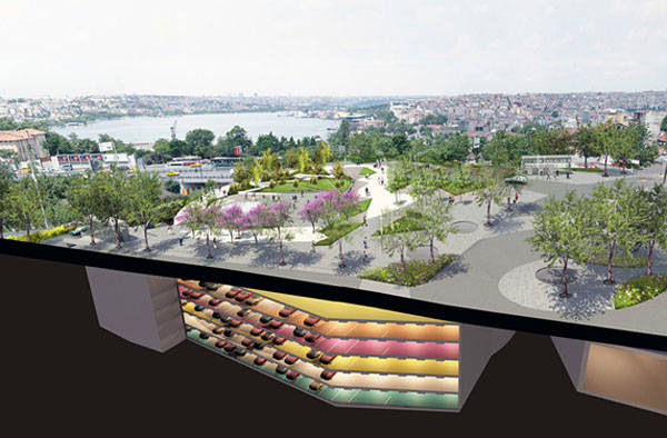
Photo Credit: Sishane Park by SANALarc
Photo Credit: Sishane Park by SANALarc by Olivia Wimmer
Sustainable Urban Design Becomes the Theater of Life
An indoor event space provides the opportunity for varying functions and opens out onto the hard-scaped central theater-like square, which is known as the “outdoor room” and is perfect for a range of cultural programming. Steps and terraces up one side of the central space aid in managing the 12-meter level change across the site, offer increased flexible seating options, and are also important in highlighting the unique features of the site that the design team wished to showcase in their sustainable urban design – those magnificent sweeping views across the old part of the city.
Photo Credit: Sishane Park by SANALarc by Olivia Wimmer
- Contemporary Landscape Architecture in China: Beautiful or Dangerous?
- Shipyard Site Transforms into Stunning Ecological Park
- Lotus Lake Park Sets Precedent for Sustainable Urban Design in China
Even the underground car park is edgy and exciting: Adorned in bright, bold colors to aid navigation, the walls also add energy and, as with much of the scheme’s detailing, show how extra effort and consideration around design and user experience can go a long way. Why should an underground, multistory car park purely be a concrete maze?
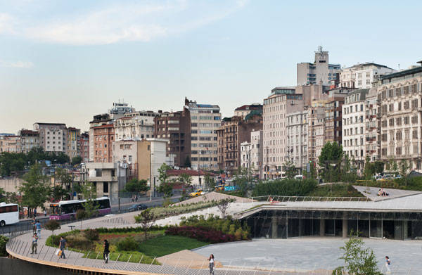
Photo Credit: Sishane Park by SANALarc by Olivia Wimmer
- Urban Design by Alex Krieger
- The Urban Design Handbook: Techniques and Working Methods (Second Edition) by Urban Design Associates
Article by Simon Vive Return to Homepage


Computer Aided Software for Landscape Architects: The Essential Guide
Your guide to all the top computer software for landscape architects. There is a plethora of Computer Aided Software or CAD options on the market. All have something to offer for everyone from the budget focused landscape architecture student to the professional wanting a fully comprehensive package. Here we take you through a range of software options to suite all budgets and needs.
Software for Landscape Architects
- Sketchup
Sketchup is a FREE 3D drafting package with probably the world’s most intuitive interface. Much maligned for its simplicity, over the years Sketchup has gotten a bit of a bad rap for being ‘blocky’ or ‘too geometric’. However I’ve always found it to be as good as the designer using it. WATCH: Instant Topography with the Toggle Terrain Tool – The SketchUp Tutorials for Landscape Architects As well as being able to work in a 1:1 scale in 3D, there is a range of tools for lighting and set camera angles. The Sketchup 3D Warehouse allows you to download models of trees and plants straight into your own model.
3D Visualisation from www.teresapottergardens.co.uk
- AutoCAD
AutoCAD, by Autodesk, comes in a comprehensive range of packages to suit most needs, and since 2012 has also supported MAC OS. Probably the most useful package for landscape architects is AutoCAD MAP 3D. This package fully supports Geographic Information System (GIS) and LiDAR (Light Detecting and Ranging) data sets, and allows you to create models over Geo-referenced rasterized images of maps.
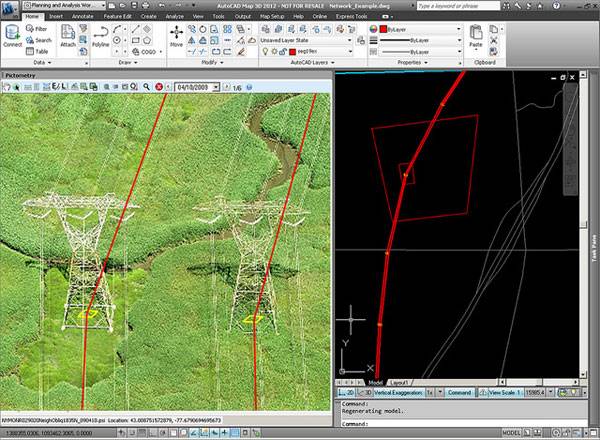
Pictometry for Autocad map 3D. Credit: @gletham GIS, Social, Mobile Tech Images; CC2.0
- LandFX
LandFX is a very comprehensive landscape architecture CAD ‘plug-in’ that generates very good hard and soft landscape plans and construction/planting details. With a database of over 20,000 plants its unlikely any user is going to run out of plants to specify. As LandFX is a ‘plug-in’ it requires full AutoCAD to run – NOT AutoCAD LT (as aposed to Keyscape which comes with its own CAD driver, and so there is no need to buy an additional CAD program). This can make it a more expensive solution and therefore perhaps not suitable for the budget minded landscape architect or landscape student. WATCH: LandFX to Sketchup Bottom line: LandFX is very powerful and comprehensive product for the professional landscape architect. However, it’s requirement for full AutoCAD might make it too expensive for some. LandFX can be downloaded here.
- ArcGIS
ArcGIS, by Esri, is a Geographical Information System (GIS) for producing intelligent mapping and Geo-spatial graphics. The two main benefits of GIS are the breadth and depth of information that can be accessed, stored, and represented for any given location; and the ease at which that information can be shared. ArcGIS offers a range of desktop based platforms, from a simple viewer (known as Desktop Basic) that allows the user to view GIS files, through to the full package ‘Desktop Advanced’. There is even an online subscription based option that ensures you have access to GIS data no matter where you are or what device you are using. ArcGIS will suit any student or professional working on planning larger areas/neighborhoods, and those working in multidisciplinary teams. WATCH: ArcGIS 10 – Calculate Area and Volume of a Reservoir Bottom line: Arc GIS is a professional tool with very powerful capabilities for landscape architects, that comes in a range of solutions to suit most budgets. The full range of Esri’s products can be explored here.
- Keyscape Design Studio
Keyscape Design Studio, by Keysystems, is a dedicated landscape package running on an AutoCAD platform. It is a very flexible package that allows you to add to the range of 2D and 3G graphics. Planting plans are easily produced using the preloaded database of over 7500 plants. Hard landscape plans can also easily be produced using a range of editable hardscape patterns. As Keyscape runs on an AutoCAD platform it is fully integrated with the industry standard file format, making sharing of files easy. There is also a lite version for the more budget minded user. From personal experience I have always found their customer support and training to be first class. Bottom line: A great piece of landscape software that allows the user a great deal of flexibility. Download a trial version of Keyscape Design Studio here.
- ArchiCAD
ArchiCAD by Graphisoft is a CAD drawing and rendering program comparable with Autodesk’s main AutoCAD program. In price there isn’t much to chose between the two, so much of the choice comes down to personal preference and differences in features. Autodesk have a propensity to create many different programs aimed at specific markets, where as the flagship ArchiCAD program is more of an all singing all dancing option, that includes BIM and sophisticated rendering. Related Articles:
- Top 10 Hints & Tips For SketchUp
- 10 AutoCAD Hacks for Beginners!
- 3D Modeling Software for Landscape Architects

Visualization of an office made in ArchiCAD 14. Credit: Menziesa; GNU Free Documentation License
- Vectorworks Landmark
There is an age old debate between those who prefer Vectorworks (VW) and those who prefer AutoCAD. Essentially the two programs approach the same solutions from different angles. AutoCAD is said to be more programmatic and efficient, while VW is said to be more intuitive to those of an artistic nature. I originally trained in VW, but moved over to AutoCAD as it is the industry standard in the UK. I enjoyed VW, and did indeed find it more intuitive and easier to create quick 3D models, but working in multidisciplinary teams requires the ability to be able to share data and generate tender and construction drawings from shared files, and so therefore I had to learn to use AutoCAD. WATCH: Welcome to Vectorworks Landmark Bottom line: VW Landmark does everything a landscape architect requires from CAD software in an intuitive and stylish way, but is not industry standard in some countries. Find out more and here.
- Rhino
For rendering of 3D models Rhino 5 offers a very capable package that will feel like second nature to any experienced CAD user. Even if you are a novice, Rhino explains what all their tools do in a straight-forward way so that you can be creating 3D CAD models in no time. There is also a range of ‘plug-ins’ available like Grasshopper and Flamingo that allow you to create photo-realistic models that are easily editable. WATCH: How to get a Free 3D Tree Library for Rhino with VRay Support Bottom line: Rhino is a powerful industry standard rendering program that offers the landscape architect everything they need to create photo-realistic rendered CAD models. FREE trials of Rhino can be downloaded here.
- Blender
Aimed at the animation and gaming market, Blender offers the landscape architect a powerful (and above all FREE) photo-realistic rendering package. Being open source software, Blender has a wide range of ever changing capabilities that allow the user to create models, and then animate them with surprisingly sophisticated tools. Features that will appeal to the landscape architect include the speed at which simple rendered models can be created, and the simplicity of walk through/fly-by animation. WATCH: Blender Tutorial: How to make a grass field? Bottom line: Blender is a great open source project that offers the budget minded landscape professional or student free photo-realistic 3D model rendering. Find out more about the Blender project here. With a such a range of CAD software available to the landscape architect it can sometimes seem daunting choosing a program. While some choices (such as AutoCAD/Vectorworks) might come down to personal preference, there are some great FREE CAD options like Sketchup and Blender that are worth investigating. What is your personal CAD preference? Recommended Reading:
- SketchUp 2014 For Dummies by Aidan Chopra
- The Complete Guide to Blender Graphics, Second Edition: Computer Modeling and Animation by John M. Blain
Article by Ashley Penn Return to Homepage Featured image: Printscreen from Youtube; source.

Viewpoint Extends Over 600 Meter Vertical Drop for Breathtaking Views
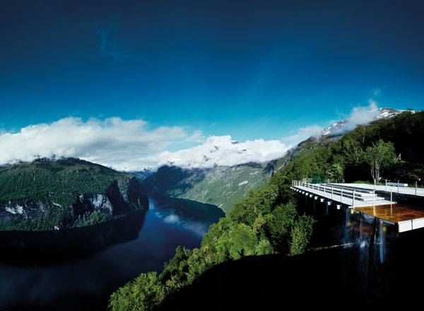
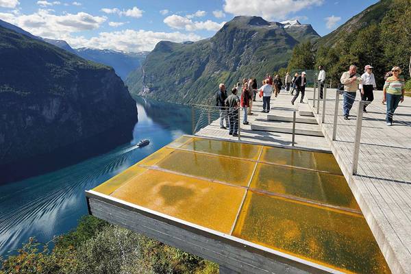
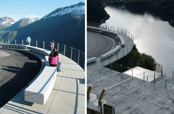
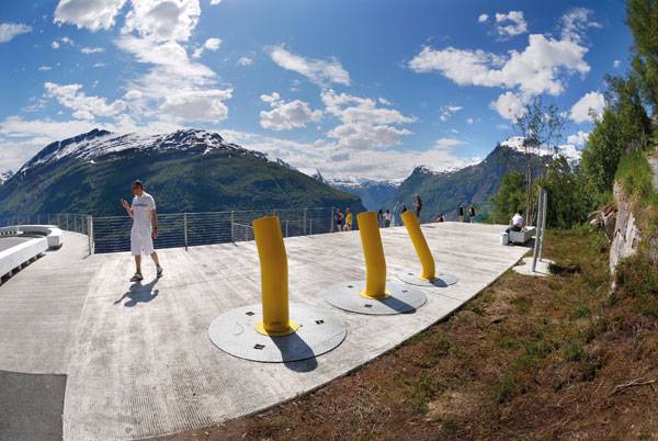
Viewpoint Ørnesvingen, by 3RW Architects in collaboration with Smedsvig Landskapsarkitekter AS in Geiranger, Norway. One of the most complicated mountain systems in all of Europe belongs to Norway, where the highways and roads follow a serpentine route of curves and bends. Because of this, the Norwegian Public Roads Administration commissioned 3RW Architects to design diverse viewpoints, paths, and outdoor furniture along The Atlantic Road to provide the environment with better tools to absorb rising pressure from the tourist industry. The Ørnesvingen site, located on across the valley from Flydalsjuvet, close to the community of Geiranger, located at the end of the Geiranger Fjord, is the most beautiful viewpoint of all the places along the Eagle Road. The space provides astounding views over the acknowledged UNESCO world heritage site, transforming it into one of the most popular of Norway’s tourist sites (600,000 people visited it in a period of five months).
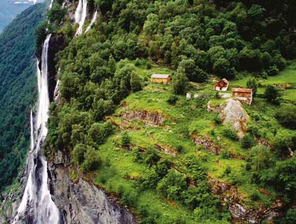
Knivsflå Geirangerfjord. Credit: 3RW Arkitekter
Breath taking views. Photo credit: Simon Skreddernes
Viewpoint Ørnesvingen, Credit: 3RW Architects
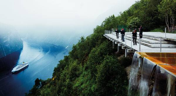
Viewpoint Ørnesvingen. Photo credit: Simon Skreddernes

Viewpoint Ørnesvingen. Credit: 3RW Architects
- Mo I Rana Waterfront Competition Winners!
- Rooftop Infinity Pool with Awesome Views
- The Garden of Hilton Pattaya by TROP : terrains + open space
WATCH: Geiranger Fjord Viewpoint (30 second video clip) Materials Used The most used material in this project is concrete, and its structural pattern was made in collaboration with artist Mai Elin Eikaas Bjerk. The material is also used as benches. The differentiation between these two elements is in the finish — while the benches are white and have a fine concrete finish, the slabs are gray and with a rustic finish.
Benches at viewpoint. Credit: 3RW Architects
Viewpoint Ørnesvingen. Credit: 3RW Architects
- Architecture in Northern Landscapes by Todd Saunders
- Site Engineering for Landscape Architects by Steven Strom
Article by Luis Eduardo Guísar Benítez Return to Homepage

9 Ways Landscape Architects Can Conserve Water
Effective and sustainable ways to conserve water in landscape architecture. As we all know, water is essential to life, whether for humans or for any other living things. Water is a natural resource necessary but perceived as a limited commodity today. Furthermore, urban development generally leads to soil sealing. This generates disturbances in the water cycle and often causes flooding following the runoff from impervious surfaces that increase water velocity and therefore causes a lot of damage. So, poor management of water can cause damage to water systems and the environment. Therefore, it is imperative to act for better water management to promote its evacuation and the recovery of its natural cycle.
Here are 9 Methods we Can Apply to Conserve Water:
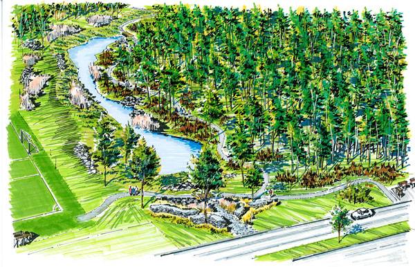
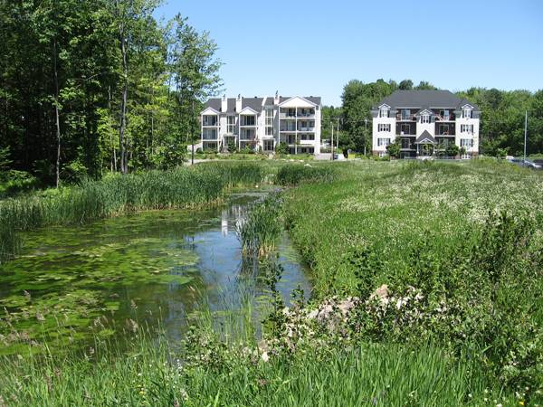
1. Meadows and floodplains When we are in a situation where runoff water is abundant and that its volume or speed can cause damage; (for example in the case of a steep slope), it is interesting to create a grassed waterway called a swale, or allow water to flood a meadow. This allows the speed of the water to slow down and acts as a filter to help retain soil nutrients as well as pesticides transported by runoff. This last point is important because in most cases these waters are headed directly into a ditch or stream. Retaining the pesticides in land allows the water quality to be improved.
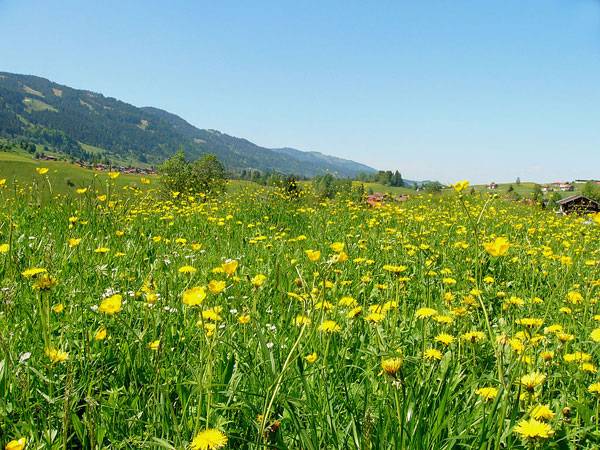
View of wildflower meadows in rural area in the municipality of Obermaiselstein located in the Allgäu region of the Bavarian Alps in southwest Germany. Credit: Nikater, licensed for Public Domain
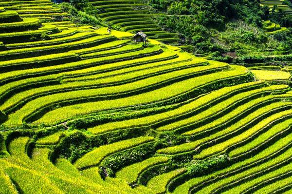
Rice Terraces. Credit: CC0 Public Domain
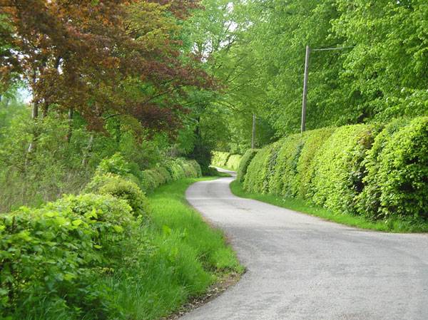
Beech hedges on the Barwhillanty Estate. Credit: Ruth Madigan, CC 2.0
Example of ditch. Credit: www.vauban.de
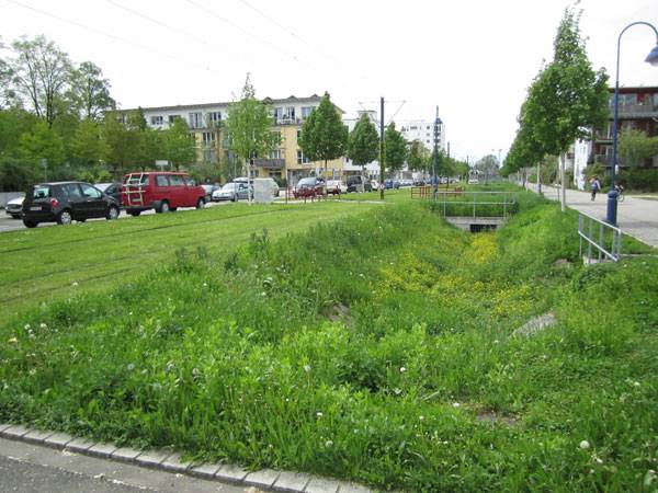
Catchment basin at the Schulz Park, St. Jerome, Canada. Credit: A. Rozières www.vsj.ca
Catchment basin at the Schulz Park, St. Jerome, Canada. Credit: Y. Lambert www.vsj.ca
- Innovation in Water Management for Stunning Landscape Design
- What Landscape Architects Need to Know About Water Shortages
- 10 Practices Showing That “Sustainability” is More Than Just a Buzzword!
WATCH: What is the value of a peat bog? 7. Maintain forests Forests have beneficial effects in every way, whether for the conservation of water and soil or as a carbon reduction and atmospheric pollution measure. For these reasons, it is important to conserve forests. But today we also see a new phenomenon, that is urban forests. This is a positive alternative when forests do not exist or are not sufficient to meet the ecosystem services we need. WATCH: Benefits of Urban Forests Regarding the conservation of water, trees play a major role in regulating the water as they participate in the water cycle, allowing a percentage of the rain to reach the ground and going directly back into the earth’s natural systems. Also, a small percentage of the rain which falls on trees evaporates directly from leaves, integrating it back into the earth’s atmosphere. Further more, planting an urban forest can reduce ambient temperatures, mitigating the effects of the phenomenon of urban heat islands, caused by surface concrete and asphalt. 8. Permeable pavements To reduce the saturation of hydrological networks and water runoff, it is important to think about making landscapes with the greatest permeable surface as possible. Thus, we can act on parking lots, tram tracks, pathway surfaces… All these combined actions allow to greatly reduce soil sealing.
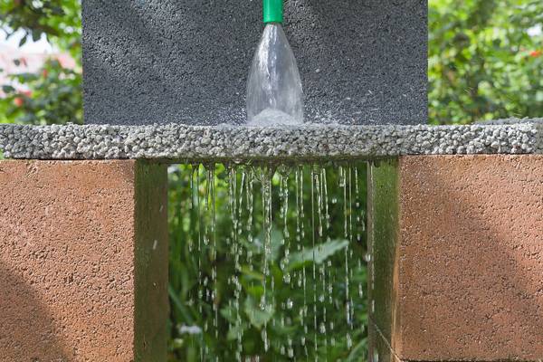
Permeable paver demonstration. Credit: CC BY-SA 3.0
JJ Harrison
- Landscape Ecology Principles in Landscape Architecture and Land-Use Planning by Wenche Dramstad
- Principles of Ecological Landscape Design by Travis Beck
Article by Alexandra Wilmet. Return to Homepage


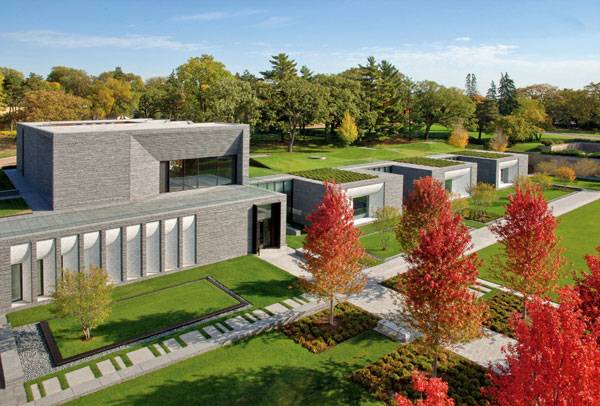
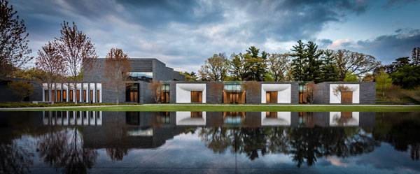
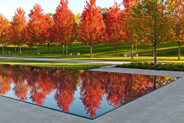
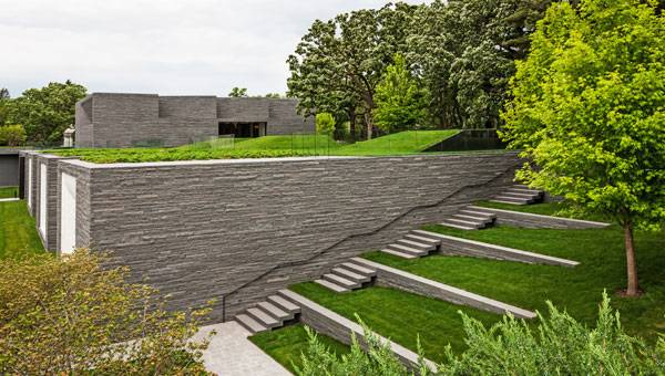
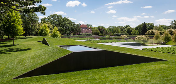
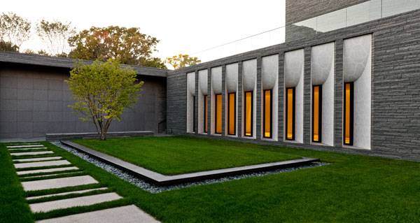
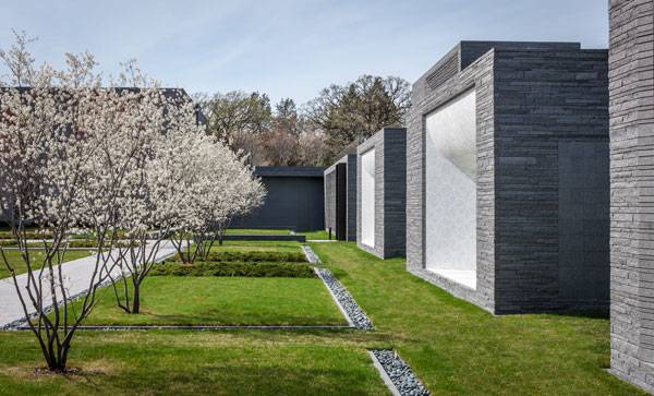
Historical Landscape Gets Modern Day Makeover
The Lakewood Garden Mausoleum by HGA Architects. The Lakewood Garden Mausoleum was considered Minnesota’s finest place for the final rest since its founding in the 1870s. Many popular names of the time were engraved on this cemetery. As time passed by, local residents developed an emotional connection with the site, making it a treasured landmark in the neighborhood. HGA Architects and Engineers had the task of leading the master plan for a full renovation. From the beginning, Halvorson’s Design Partnership’s lead architect gave advice for the landscape composition and helped as a highly valued design team member until the renovation was complete.
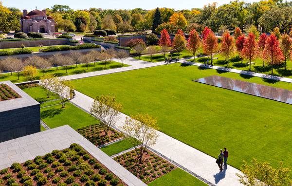
Lakewood Garden Mausoleum Landscape. Photo credit: Paul Crosby
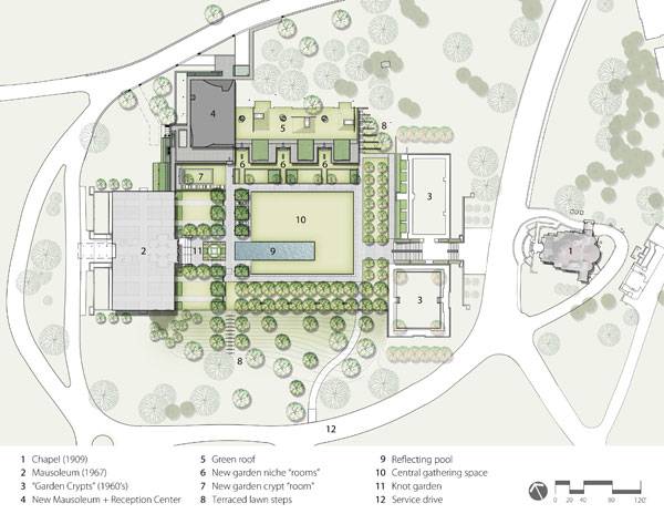
Plan of the Lakewood Garden Mausoleum Landscape. Credit: Halvorson Design Partnership, Inc.
An Historical Landscape
Laid over 250 acres, the Lakewood Cemetery was founded in 1871. It was governed by the Lakewood Cemetery Association, a non-profit organization that ensured the vitality of the mausoleum with its master plan and space saving for future development. The renovation planning started in the late 1990s, and cemetery trustees finally commissioned the work in 2003. The project included a new garden mausoleum for more than 10,000 graves and a full landscape makeover.
Lakewood Garden Mausoleum Landscape. Credit: Lakewood Cemetery
Lakewood Garden Mausoleum Landscape. Photo credit: Paul Crosby
Lakewood Garden Mausoleum Landscape. Photo credit: Paul Crosby
Lakewood Garden Mausoleum Landscape. Photo credit: Paul Crosby
- The Landscape of Death and Green Burial – How Our Beliefs Design Cemeteries
- 15 Great Examples of Historical Landscape Architecture
- Giant Sized Pergola Creates Ecological Haven
Lakewood Garden Mausoleum Landscape. Photo credit: Paul Crosby
Lakewood Garden Mausoleum Landscape. Photo credit: Paul Crosby
Lakewood Garden Mausoleum Landscape. Photo credit: Paul Crosby
- Graceland Cemetery: A Design History by Christopher Vernon
- Stories in Stone: A Field Guide to Cemetery Symbolism and Iconography by Douglas Keister
Article by Eduardo Reguer Return to Homepage

The Dark Art of Conceptual Design in Privately Funded Public Space
The City Dune by SLA and buildings by Lundgaard & Tranberg Arkitekter, Copenhagen, Denmark. Public spaces should be the heart and soul of every city; they might be the meeting places for the citizens, the areas where people gather, spend time, socialize. The potential is endless – however, this is often unfulfilled, leaving the spaces underused, empty, lifeless and forgotten. Fortunately, more and more areas are getting revitalised, invigorated and refurbished for the benefit of local communities. Such great public spaces are always full of life. They are functional, they can be used in a variety of different ways. It takes a team of wonderful landscape architects to design a working urban space – Danish studio SLA managed to succeed with its project, the City Dune, designed and constructed for the leading Nordic bank, SEB.
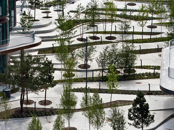
Photo credit: The City Dune, SLA, by OREV-Vandingssystem
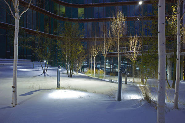
Photo credit: The City Dune, SLA , by Jens Lindhe
Conceptual Design at the Forefront
The concept of the design is enclosed in its name – the area is supposed to represent a giant urban dune (covering 7300 m2,, with its top elevated 7 metres above the street level), inspired by the sand dunes of North Jutland as well as by the snow dunes, which are a common occurrence during Scandinavian winter. Denmark has strong ties to the sea, and Copenhagen is its coastal capital. On top of that, the site is the Scandinavian headquarters of the Swedish bank. The multi-layered conceptual design reference to the dune is therefore understandable and meaningful for the locals. One of the main aims of the design is to ensure easy and intuitive communication routes across the whole area, connecting the busy street with the bank’s office buildings and the area behind them. The spatial arrangement of the dune’s slope encourages the movement of the cyclists and pedestrians across the space, along alternative routes. It also makes for a great space for skateboarding.
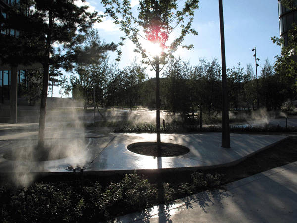
Photo credit: The City Dune, SLA, by Jens Lindhe
- Copenhagen’s First Climate Resilient Neighbourhood
- Can Copenhagen Become the Best Cycling City in the World?
- Cool Pavements: The Essential Guide
Materials and Sustainability The most prominent material used in the area is white, folded concrete. This huge, white surface has an added benefit of repelling the heat radiation and making the area cooler during the Summer, in a similar way to Julia Lucchese explains in her article – Cool Pavements: The Essential Guide. The shiny contemporary space is divided by pockets of greenery – large herbaceous borders and individually planted large trees. The variety of plants enhances the value of the urban space at all times of the year.
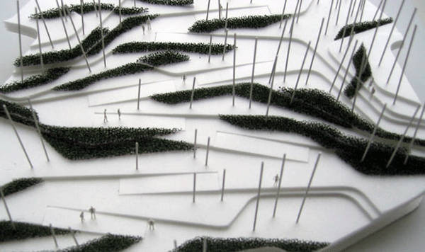
Photo credit: The City Dune, SLA
Photo credit: The City Dune, SLA , by Jens Lindhe
- Heat Islands: Understanding and Mitigating Heat in Urban Areas by Lisa Gartland
- Designing Small Parks: A Manual for Addressing Social and Ecological Concerns by Ann Forsyth
Article by Marta Ratajszczak Return to Homepage

10 Awesome Riverbank Projects
A look at some of the world’s most outstanding riverbank projects. When it comes to building sustainable cities, discussion often centers on urban rivers and their surroundings. In many cities around the world, rivers have been channelized, transformed into receptacles for waste disposal, or just forgotten when they are no longer needed for industrial and commercial uses. As a consequence, these rivers have lost their innate ability to aid in flood control, seen their aquatic life destroyed, and gone unnoticed due to construction of barriers that blocked their access and hid them from residents’ eyes. But in other cities, once dead spaces along rivers are being brought back to life and transformed into recreational areas, meeting the demand for outdoor spaces from quickly growing populations. As in music, where the notes and the pauses have equal importance, an increase in constructed areas must harmonize with green space to guarantee liveable cities for the future.
Inspiring Riverbank Projects
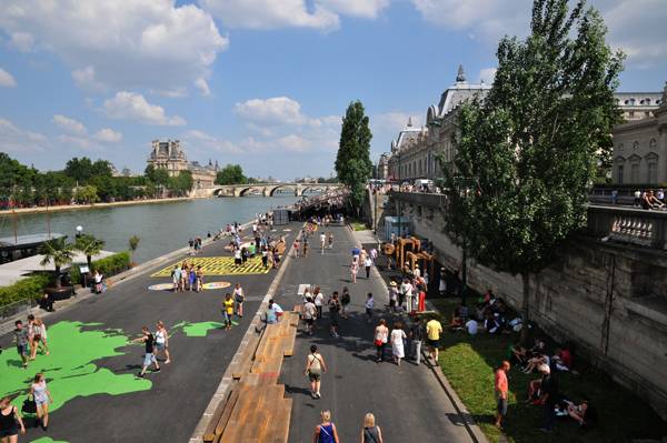
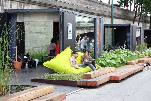
Riverbanks can set the new pace for this composition. The following list offers some of the most inspiring river transformations that have improved the relationship between city residents and nature, inviting people to look at rivers not as obstacles, but as vital and connective urban components. 10. Berges de Seine, Paris, France, by Franklin Azzi Architecture The combination of historic bridges and monuments along the Seine River has made this place one of the top tourist attractions in the world. Some may think that the designation of the famous riverbanks as a UNESCO World Heritage Site means that the place cannot be changed. But the initiative of the local authority, known as Berges de Seine, is showing that historic riverbanks can be modernized to adapt to the current needs of a city.
© FRANKLIN AZZI ARCHITECTURE
© FRANKLIN AZZI ARCHITECTURE
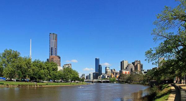
Yarra River & City Skyline Credit: By Donaldytong, CC 3.0
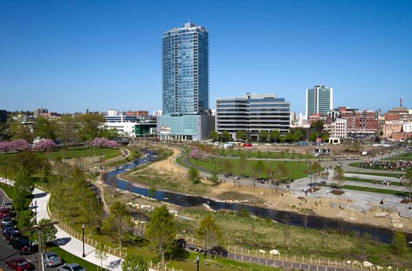
The rejuvenated river embankment; credit: Olin
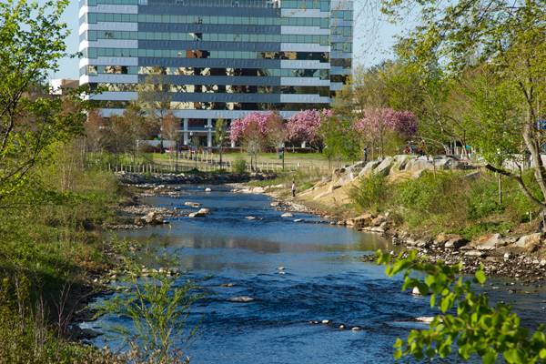
Mill River Park; credit: Olin
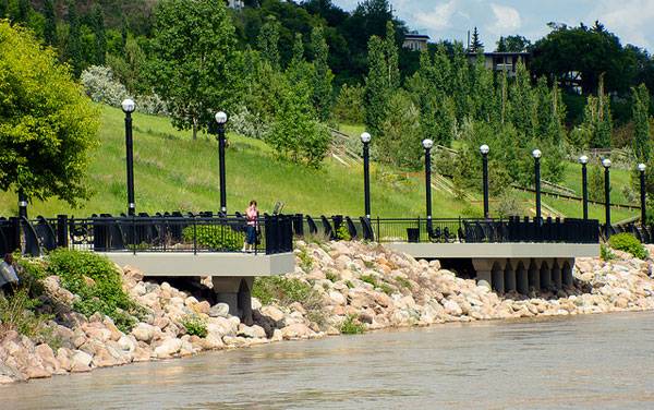
Riverfront Promenade. Photo credit: Kurt Bauschardt, CC 2.0
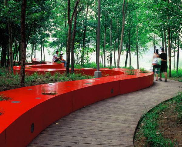
The Red Ribbon as romantic meeting place at Qinhuangdao City, Hebei Province, China. Credit: Turenscape
- How Industrial Landscapes Can Become Beautiful Sites
- Extraordinary Development Re-connects City With The River Bank
- RheinRing Bridge is a Work of Art!
Since its completion in 2008, the 20-hectare green area that replaced the formerly inaccessible riverbanks is being massively used by the growing urban population without compromising the goals of preservation of the environment. The ribbon has been working as a key component of this success because it is the “spine” that provides structure to the space and makes reference to ancestral Chinese myths of energy flow, allowing people to identify with the environment through their cultural heritage.
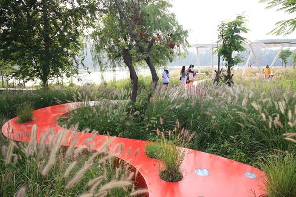
The red ribbon runs across open the field of a former garbage dump at Qinhuangdao City, Hebei Province, China. Credit: Turenscape
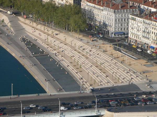
The Rhone River Bank. Credit: IN SITU Architectes Paysagistes.
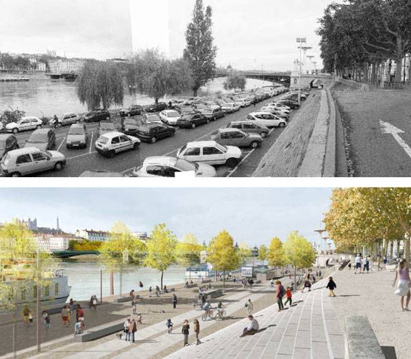
Before and after – The Rhone River Bank. Credit: IN SITU Architectes Paysagistes.
This industrial site represents 50 years of Socialist industrial history and was a witness to China’s Cultural Revolution. Credit: Turenscape

Rio Madrid by West 8. © Municipality Madrid

Rio Madrid by West 8. © Municipality Madrid
- Landscape Architecture Now! by Philip Jodidio
- Landscape Graphics by Grant Reid
Article by Tania Gianone Return to Homepage

Top 10 Most Controversial Monuments of the World
Monuments across the globe.
Monuments have been an important part of our landscapes for millennia. Some of them have been accepted by their communities almost immediately, while others raised controversies, complaints, or even protests. Sometimes it takes time for a monument to grow into the landscape and to become part of it or even an icon or a landmark. Who knows, maybe the ancient Egyptians complained about the Sphynx or the pyramids — who can now imagine Egypt without those majestic constructions? Other structures don’t pass the test of time and are either universally hated, or removed and forgotten. We are presenting the list of the monuments that raised the most controversy in their time. Find out which are still doubted, and which became well loved.
10. Obelisco de Buenos Aires, Buenos Aires, Argentina
The Obelisk, BUENOS AIRES, ARGENTINA; image credit: Anibal Trejo / shutterstock.com
Designed by Alberto Prebisch and erected on Plaza de la República in 1936, the Obelisco is now an icon of Buenos Aires, but it wasn’t always so. The residents of the city strongly objected to its “unimaginative and stark appearance”. Their resentment was enhanced by the fact that the monument took the place of a church, which was demolished to give way to the Obelisco and Av. 9 de Julio. During its history, the monument has witnessed political events and protests and was a part of several art projects.
9. Christ of the Pacific, Lima, Peru
Christ of the Pacific, Lima, Peru; image credit: Christian Vinces / shutterstock.com

Pyramide du Louvre, Paris, France; image credit: William Perugini / shutterstock.com
Built in 1989 as a new, modernist entrance to the Louvre Museum, it has since grown into the Parisian landscape. At the time of the monument’s construction, it raised controversy due to the ultra-modern character of the structure placed right in front of the classical palace.
The monument’s popularity wasn’t helped by the legend that the Pyramide contains 666 glass panes. There were even accusations that the American architect, I.M. Pei, destroyed the very heart of Paris. However, people seem to have grown used to this iconic structure.
7. Valley of the Fallen, Spain
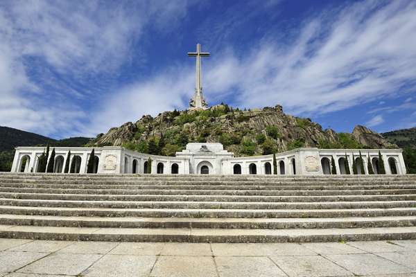
Valley of the Fallen, Spain; image credit: Andrey Lebedev / shutterstock.com
The massive basilica carved in the mountainside by political prisoners was ordered by General Franco to commemorate those who died during the 1930s Spanish Civil War. Years of controversy and protests resulted in an assembly of a commission to establish its future. More than likely, Franco’s body will be removed from the site and the whole monument might be redesigned as a “monument to Democracy”.
6. Jesus statue in Poland
Reaching 36 meters in height (52.5 meters including its mound), this is officially the tallest statue of Jesus in the world. It rises from a large plain near the Berlin-Warsaw motorway, opposite a large Tesco supermarket. Its grandeur and less-than-glamorous location have made it a subject of ridicule and tasteless jokes. There have also been concerns regarding the safety of the monument. The whole project was finished in 2010, at the cost of 6 million PLN, enirely funded by the local community and the Polonia.
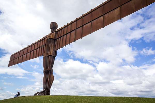
WATCH: (Ametuer) Video footage of Jesus statue 5. The Angel of the North, Gateshead, Tyne and Wear, England The formerly controversial monument, which became a landmark for North-East England, was raised between 1994 and 1998 on a hill on the southern edge of Low Fell. Most people now feel a connection with this iconic structure; however, during its construction, numerous concerns were raised.

GATESHEAD – MAY 30: Angel of the North Statue on May 30 2010 in Gateshead, England. It is a steel sculpture of an angel, 20 metres tall, with wings measuring 54 metres across. Image credit: donsimon / Shutterstock.com
- Giant Rabbit Art Has Tourists Flocking to See it!
- Amazing Kinetic Sculptures That Could Hypnotize You
- The Art and Science of Wind Propelled Sculptures
4. African Renaissance Monument, Senegal
This monument, commissioned by President Abdoulaye Wade and unveiled in 2010, was widely criticized both for its huge cost and for sexism, as well as for the skimpy clothing of the depicted female and the lack of style. The sculpture shows a muscular man, with a baby in his arms, emerging from a volcano, pulling along a half-naked woman.
It is the tallest statue in Africa, designed by a Romanian architect and built at the cost of 27 million American dollars by a North Korean company, which also was a matter of controversy. WATCH: Monument De La Renaissance Africane
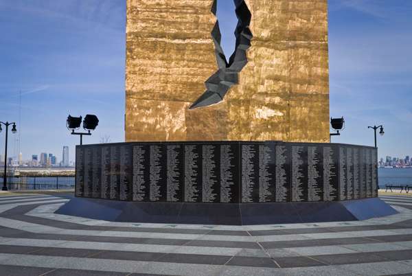
3. To the Struggle Against World Terrorism, Bayonne, New Jersey, USA
This huge statue was given to the United States by Russia in 2006. It was first supposed to be placed in New Jersey City, but the city refused and it ended up in Bayonne. The monument is shaped out of steel and coated in bronze. The 30-meter tower is split in the middle, with a large, stainless steel teardrop hanging in the opening, as a memorial to those who died during terrorist attacks in the U.S.

BAYONNE, NJ : A View of the Teardrop Memorial in Bayonne, NJ on March 9,2012. The Teardrop Memorial is a gift from Russia To the Struggle Against World Terrorism dedicated in 2006. Image credit: Andrew F. Kazmierski / shutterstock.com

The Eiffel Tower, Paris, France; image credit: EUROPHOTOS / shutterstock.com
The Eiffel Tower must be one of the first names that spring to mind when thinking about Paris. Can anyone imagine this city without that towering, iconic structure? However, it wasn’t always like that; the construction of the tower was incredibly controversial and caused a lot of protests among the artists and architects of 19th-century Paris.
They raised concerns regarding the feasibility of the structure and complained about the tower destroying the landscape of the city. Some of the opponents accepted the tower once it was built; others continued to hate it for the rest of their lives. 1. The Arch of Neutrality, Ashgabat, Turkmenistan

The Arch of Neutrality, Ashgabat, Turkmenistan; image credit: velirina / shutterstock.com
This true vanity monument was erected by the Turkmenistan “president for life” Saparmurat Niyazov in celebration of his adoption of neutrality as his official policy. The Arch of Neutrality was a rocket-shaped tower, topped with a gold statue of Niyazov himself. The statue rotated during the day, so that his face was always in the sun.
Built in 1998, at a cost of more than $12 million, the structure was an outrageous monument to the pride and vanity of one person. As ordered by the new president, Berdimuhamedow, the arch was dismantled in 2010 and replaced with a 95-meter-tall “Monument to Neutrality”. The new monument is located in the suburbs. The golden statue is a part of it, but, sadly, it no longer rotates.
What makes a monument controversial? How come some of them become truly a part of a surrounding landscape, while some stick out like a sore thumb?
Recommended Reading:
- 100 Landmarks of the World: A Journey to the Most Fascinating Landmarks Around the Globe by Parragon Books
- Public Art: Theory, Practice and Populism by Cher Krause Knight
Article written by Marta Ratajszczak
Return to Homepage Featured image: Andrew F. Kazmierski / shutterstock.com