


As volatile weather events increasingly become the norm, the importance of designing to support dynamic ecological processes – and proactive planning not just for operations and maintenance, but for the inevitable, ensuing recovery efforts – has never been more critical.
A pioneering project in China’s Hunan Province, the Baxi Island River Forest exemplifies both the importance of designing in harmony with nature as well as the tremendous challenges associated with changing climates and rising water levels. The project was conceived as a catalyst to regional development and eco-tourism within the larger Dawang Mountain Development Zone.
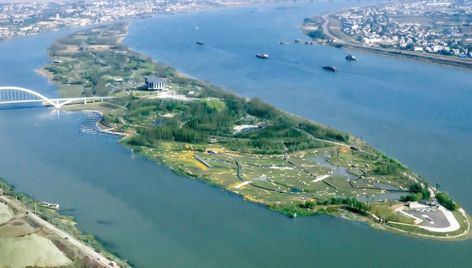
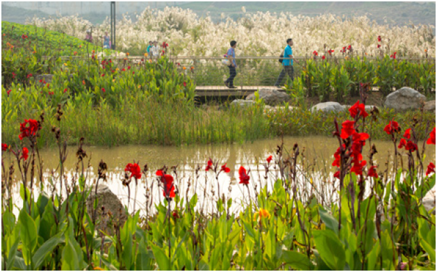
The design of the two-mile-long River Forest Island derives from natural processes and cultural traditions in Changsha, tansforming an island disturbed by flooding, erosion and loss of habitat into a resilient and ecologically diverse park with vibrant gathering places that reconnects the people to the river. Image: swa group
One of 16 islands along the Xiang River in Changsha, the 156-acre Baxi Island had for many years been a private island sandbar covered with poplar trees and various structures, until being adapted into a recreational setting intended to reconnect people with the river and an immersive wetland environment beginning in 2014. It now draws more than 100,000 annual visitors who explore the local flora and fauna of lotus ponds, reed beds, gardens, meadows, and towering Metasequoia forests, as well as manmade elements like a museum, playgrounds and café.
Various strategies of underwater embankments and deep-rooting plants were installed to reduce water velocities and defy erosive forces, offering opportunities for different experiences along walks and outlooks at the river’s edge, with 1/7 the cost of conventional hard edge. Image: swa group
Rather than following a typical engineering approach – building a large levee that separates people from the river and blocks the riverfront habitat – the design team deliberately designed a nature-friendly island edge to embrace nature and bring people to the riverfront, accommodate river fluctuation, and help establish wetland habitats. Notably, this approach cost about 1/7th the price of the conventional approach.
Summer Condition (left); Winter Condition (right) | Image: swa group
The site design features a series of landforms shaped to accept seasonal flooding and allow water to flow through the island, with high ground levels situated to accommodate water levels of approximately 120 feet, which represented a 100-year flood at the time of the project’s design. Designing to these flood parameters, which were considered accurate at the time, meant that major flooding and ensuing recovery efforts would take place from time to time, but certainly not on an annual or biannual basis. However, changing climates have demonstrated the need to reevaluate long-established parameters for what had long been considered generational weather events.
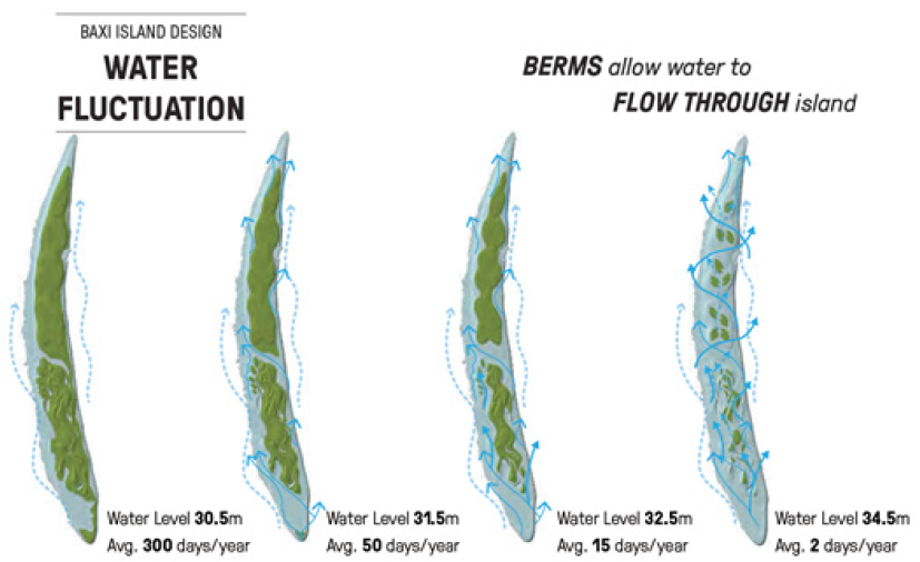
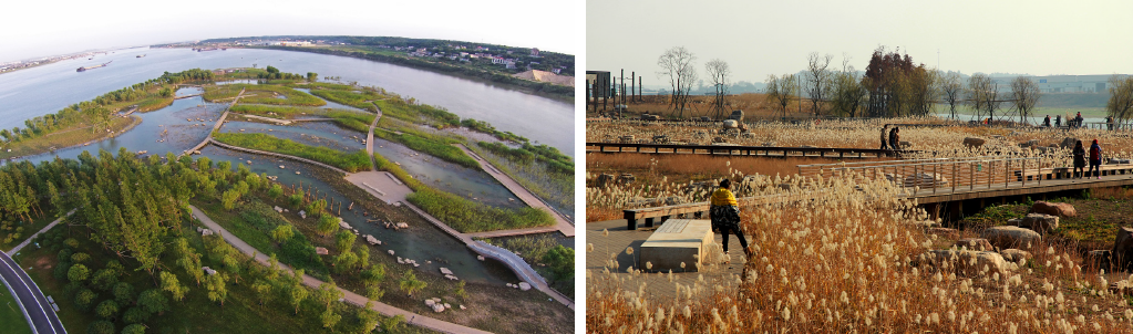
Variable grading turns the threat of the flood into a safe and spectacular display, where different water levels offer opportunities for diverse habitats. Image: swa group
Record Flooding
In 2014, area flooding saw Baxi Island’s water levels reach approximately 107.2 feet, while 2016 floods saw waters exceed 111.5 feet and, in 2017, record flooding saw waters reach as high as 129.5 feet. In July 2019, waters again reached high water marks that rendered this popular visitor attraction unsuitable for recreational use. All of these events, over the course of a five-year period, exceeded the 50-year recurrence interval.
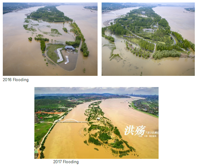
Image: swa group
The result of such flooding is an island inundated with murky river waters, extensive silt deposits on walkways, and flood debris strewn about by the water’s movement. Locally, these conditions have drawn consternation. Many are confounded by the park’s rapid transformation from vibrant wetland ecosystem to a water-logged island with minimal allure – and the extensive efforts required to remove silt from walkways and clean up the site – but the reality is that was exactly the design intent and reflects how natural river processes affect the site. The unexpected variable: experiencing what had been considered 50- and 100-year flood events on an annual or biannual basis.
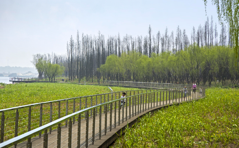
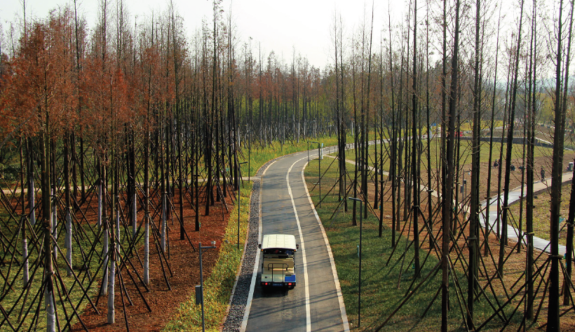
Situated in a dynamic river environment, the project was designed to flood — in fact, riverine wetlands require annual flooding to replenish soils with nutrients and maintain plant biodiversity. The site has performed remarkably well in light of the increasingly disruptive flood events. Buildings and primary gathering areas were sited at high points on the island, and the inclusion of approximately 15,000 native Metasequoia trees — a hearty species from China chosen to withstand flooding — serves an important ecological function, helping to stabilize the island soil, reduce water velocities through the site, and form the backbone of the lowland forest, from which a series of gardens and meadows emerge. The overall sculpting of the park’s landforms has been highly successful, but many important lessons have emerged through the trials and tribulations.
15,000 native Metasequoia trees stabilize island soil and form the backbone of the lowland forest, from which a series of gardens and meadows emerge. Image; swa group
Recovery
One year after the 2016 flooding – in which water levels rose to 111 feet, representing a 50-year flood – Baxi Island saw water levels exceed 129.5 feet in 2017. Plants were underwater for approximately nine days, silt levels reached 18 inches in some areas, and total damages were approximately $7.5 million. Water levels exceeded 108 feet for 12 days after that flood, an event that should only happen once in a hundred years.
Flood recovery efforts included remediation of infrastructure, public facilities, vegetation, attractions and primary gathering areas, and dredging and landform recovery. Plant recovery was based on elevation. Of course, flood debris and wood recruitment provide added layers of habitat structure that benefit natural areas, but this material can alternatively be viewed as litter in managed recreational spaces.
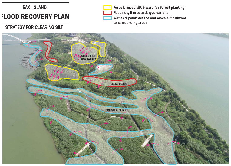
Strategies for clearing silt similarly followed specific plans for distinct areas. Image: swa group
Strategies for clearing silt similarly followed specific plans for distinct areas. In the forests, silt was moved inward for forest planting; on roadsides, silt was cleared up to a five-meter boundary; and wetlands and ponds were dredged and silt was moved outward to surrounding areas. The water pavilion remained in good condition and only required clean up and weed clearing. The lotus pond only required spot repair, including dredging silt and clearing weeds. Waterways were dredged for silt, weeds were cleared, and groundcovers were replanted. Reed beds are now regularly harvested and replanted as part of the recovery plan and trails were cleared of weeds and replanted. A series of sustainable practices was implemented as well. These approaches include controlling and clearing invasive plants for reuse, harvesting and reusing wetland plants, and clearing and reusing dead wood.
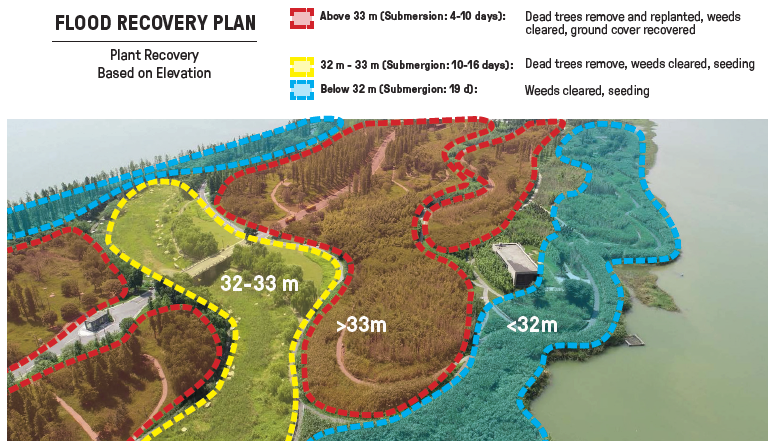
Plant recovery was based on elevation. Of course, flood debris and wood recruitment provide added layers of habitat structure that benefit natural areas, but this material can alternatively be viewed as litter in managed recreational spaces. Image: swa group
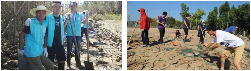
The recovery was a collective effort of public and private entities, including participation from a governmental flood control group, more than 10 nongovernmental organizations, and private companies specializing in electrical, lighting, plumbing, and garden management. Their efforts showcase the community’s investment and sense of ownership in caring for this treasured natural environment.
Recovery efforts have included a wide array of public and private entities. Image: swa group
July 2019 again saw extraordinary flooding, requiring another intensive recovery effort to clear debris, silt and remediate the site. Notably, Baxi Island’s sister island, Tangerine Island, which has a more conventional engineered approach with a large levee, had similar post-flooding recovery problems as Baxi Island.
The Bayou City
Of course, extreme weather events are not limited to China – they’re increasingly ubiquitous and, with changing climates, will only further impact people and communities across the globe. In the U.S., the nation’s fourth-largest city, Houston, Texas, is also acutely aware of how changing climates have resulted in more frequent and impactful weather events.
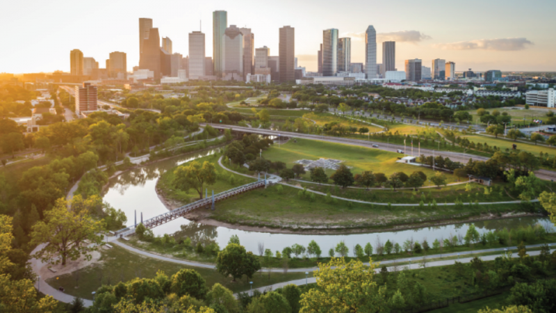
As a low-lying metropolis with a humid subtropical climate, Houston is well accustomed to significant rainfall in short periods of time; the city receives more than 50 inches of rainfall annually and the downtown area is a mere 50 feet above sea level. A series of drainage channels and bayous has long been in place to help manage this tremendous volume of stormwater, but flooding in recent years has challenged even those long-established systems. Most of these bayous were channelized and concretized by the Army Corps of Engineers years ago, but Buffalo Bayou, a 500-square-mile watershed, was largely converted back to a more natural condition in recent years and is one of the region’s most vital green spaces. It includes a 160-acre linear park that has been greatly enhanced in recent years with extensive trails, lawns, meadows and parks, which are well used and cherished by locals.
In June 2001, Tropical Storm Allison dropped more than 30 inches of rain in 24 hours over parts of Houston, and was designated a greater than 500-year event that was “off the charts.” More recently, over Memorial Day in 2015, Houston received approximately 12 inches of rain in a 10-hour period, causing extensive damage. In April 2016, an average of 12 to 16 inches of rain fell in a span of 12 hours, again causing widespread damages. The following year, in August 2017, Hurricane Harvey shattered those marks, dropping more than 45 inches of rain in multiple regional locations over a four-day period; it was the largest recorded rainfall event in American history. During Harvey, floodwaters rose 38.7 feet at Buffalo Bayou’s western end.
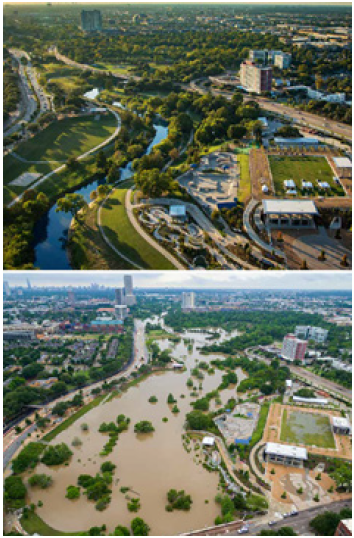
Houston has experienced a series of significant flood events in recent years including major storm events over Memorial Day in 2015, in April 2016, and a record-breaking flood in August 2017 due to Hurrican Harvey. Image: swa group
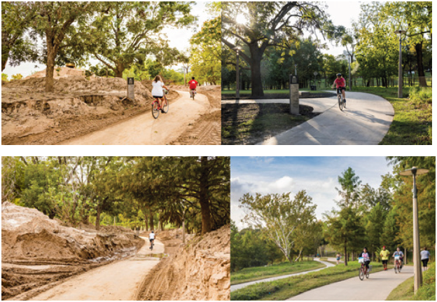
These heavy flows from tropical storms, along with an otherwise natural channel slowly adjusting from a pastoral watershed to a highly urbanized watershed, resulted in upstream bank erosion, which deposited deep and heavy silt deposits along the greenway parkland, where the channel opened up and the water slowed down. Similar to the challenges at Baxi Island, and although silt removal strategies were designed into the park, much silt needed to be removed from trails and other low-lying park facilities. Over time, some of the park features are being adjusted to better accommodate removal of these more frequent, silt-laden storm events.
Buffalo Bayou plays an integral role in Houston’s resilience to increasingly common flooding. Image: swa group
Buffalo Bayou’s design helped the city overcome this extraordinary calamity and rebound through its ecological performance. Its design incorporates channel stabilization techniques that enhance the bayou’s natural meanders and provide increased resiliency against floodwaters. The planting strategy prioritized riparian woodlands and naturalized meadows of native species over mowed turf, providing further landscape stabilization and native habitat. Notably, Buffalo Bayou is maintained by a vast network of local municipal and regional entities, nonprofit organizations, and dedicated volunteers, all of which are integrally important to the project’s success.
Takeaways
Considering how many major cities exist in low-lying areas, heeding lessons learned from both Baxi Island and Buffalo Bayou is vitally important. Longstanding flood levels associated with generational storm events should be reevaluated on a regular basis due to changing climates. These numbers clearly are not static, and are becoming increasingly dynamic with changing climate patterns.
A tremendous ecological and cultural resource, Baxi Island’s more than 50 local plants were allocated according to their water resiliency and functionality in purification and habitat establishment. Authentic values and seasonal changes were also considered to maximize value for both the ecosystem and visitors. Image: swa group
River advocates and government officials both recognize that our understanding of storm intensity curves and recurrence intervals are based on relatively short historical recordings and that, added to that, we are experiencing unprecedented changes to weather systems worldwide. As a result, flood water elevations and storm recurrence intervals are being reevaluated in many locations, and project planners and designers are being encouraged to prepare for and to accommodate higher, deeper and faster flows throughout large and small watersheds.
Planning for operations and maintenance from design inception is critical, including development of flood recovery plans. New techniques should constantly be explored – perhaps a series of modular walkways on stilts, which could be elevated every few years, should become the norm in these recreational wetland environments. Most importantly, we must embrace natural ecological systems and processes – because in the battle between man and Mother Nature, Mother Nature will always win.
*Special thanks to SWA Houston’s Kevin Shanley and Mark Merkelbach, a civil designer and professional wetland scientist with Green Earth Operations, for their tremendous insights that helped inform this article.
This article was written by:
 Sean O’Malley, PLA | The Managing Principal of SWA’s Laguna Beach office, Sean O’Malley has more than 30 years of professional experience encompassing all aspects of landscape architecture, urban design and planning. His multidisciplinary skill set allows him to develop sophisticated design solutions at a variety of scales across the development transect. Sean’s design interests are rooted in environmental infrastructure and the integration of a site’s natural structures with its development potential, blurring the distinction between landscape and architecture. He was worked on projects throughout the United States and across the globe, including many significant projects in China focused on creating more resilient built and natural environments. Sean received his Master of Landscape Architecture in Urban Design from Harvard University’s Graduate School of Design and his Bachelor of Science in Landscape Architecture from California State Polytechnic University in Pomona, California.

Xiao Zheng, LEED AP | A Principal in SWA’s Laguna Beach office, Xiao Zheng has 18 years professional experience, and both her landscape and architecture backgrounds bring a unique perspective to projects. Her design passion is for urban settings with a focus on integrating city with nature, culture and economic aspects in both artistic and sustainable approaches. She also has extensive experience with international projects including large-scale city planning, urban design, retail, park, and residential community projects. Xiao has a comprehensive understanding from planning through construction, inception through realization. She also has a keen eye for detail, knowing what it takes to build a successful project, including an understanding of innovative materials and construction methodologies. Her background includes a Master of Landscape Architecture from the University of Pennsylvania and a Master of Architecture from South China University of Technology.
Published in Blog, Cover Story, Featured


J. Robert (Bob) Wainner
Assuming…that everything written here is “true”……I’m wondering. WHY did Barack & Michelle Obama (both major advocates of the “green energy movement & climate change issues”…..purchase a very expensive, multi-million Residence in the Cape Cod area…on several Acres of land that are right on the Atlantic Ocean? I’ve seen photos of that home and property…the Finish Floor grade of that home can’t be over 5 feet above Sea Level. AND, the Obamas also own the Hawaiian Seaside Home (one used to film the TV Series “Magnum P.I. with Tom Selleck”…..if the Seas are indeed rising, WHY would the OBAMAS own (2) homes sitting right near the Atlantic & Pacific Oceans???
WHY…..don’t the OBAMA’s practice what they preach?
According to NASA……the Seas are actually rising @ a rate of (Point 1 inch) per Year. How do you even measure that amount?
IMO……This is just another “Liberal leaning” Article here on LAND 8. I’d like for someone to explain to me WHY a vast majority of Americans live in homes that are situated so close to Oceans, Lakes and Rivers. Why are there STILL thousands of new resorts, condos, homes, etc. being planned for Beachside locations?
I believe that people (even experts) believe that the Seas are rising all around VENICE, ITALY…….no, I feel sure what’s going on with Venice……is that City is actually “sinking”.
Bob
J. Robert (Bob) Wainner
Seriously…all we seem to get here on LAND 8 with these BLOGS are…..Liberal leaning articles telling us “THE SKY IS FALLING”…..Landscape Architects MUST do something.
The “Planet Earth” is always changing…seas rise and fall…weather is always changing & it always will. Does anyone really truly believe that mankind can “change” the Weather here on Earth? If so, I would like to personally meet that person or organization….because, I know, they do not exist. Plans like “The New Green Deal” are just plans for the Liberals of this World to TAX all the people heavily for a program the can’t truly believe will actually work.
Each nation must take responsibility for their own Air & Water Pollution Issues….and Flooding, as they can. The U.S. just can’t be responsible or fund their problems. America is already the most generous Nation on the Planet….giving Billions of foreign aid to many Nations. The NEW Conservative led movement “The Trillion Tree Plan” is, I believe, a very good plan…to help reduce the CO2 issues on the Planet.
I really believe that the Planet Earth has always had a way of healing itself or adjusting.
Experts who really “understand” the so called Global Warming issue say…..it’s better to have a “Warm Planet” than a cool planet….for the sake of people, animals and the ability to grow food.
I personally, would just like to see LESS of these Liberal leaning LAND 8 Blogs…..With all due respect, they just all tend to read like a University Landscape Architecture Professor wrote them……and I think we all know, about 90% of the University Professors in our Universities are……..Very Liberal.
Bob
Pingback: Flooding by Design - Pro Landscaper Magazine USA