


Author: Jeff Gonot


NYC Landscape Architecture Travel Series #8: National September 11 Memorial
Visiting the eloquently designed National September 11 Memorial was a sobering and emotional experience. The almost overwhelming sense of loss is magnified by the massive reflecting pools marking the voids where the twin towers once stood.

Designed by architect Michael Arad and landscape architect Peter Walker, the 9/11 Memorial is a site of tribute and remembrance to the nearly 3,000 lives that were killed in the September 11 terror attacks. The eight-acre quadrant features twin reflecting pools–each nearly an acre in size–that also hold the largest manmade waterfalls in North America. The names of every person who died in the 2001 attacks and 1993 WTC bombing are engraved along the edges of the Memorial reflecting pools.

A lush and minimalistic landscape design supports the architecture and pools.

Reflection of the Freedom Tower in the Museum window, which is set to open next year.

From the north pool, looking at the Museum. The names circling the pools are a reminder that this is a place of mourning, a memorial to those that lost their lives and to those as part of the first responders.

This concludes my landscape architecture travel series around New York City. Thank you for taking the time to read, and hopefully learn about some of the city’s unique parks and urban designs! Please feel free to share your thoughts in the comments below.
NYC parks I visited:
1. High Line
5. Paley Park
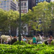
6. Bryant Park
7. Central Park


NYC Landscape Architecture Travel Series #4: Prospect Park
In today’s NYC travel installment, landscape architect Jeff Gonot takes us deeper into Brooklyn to visit Frederick Law Olmsted and Calvert Vaux’s other crown gem in New York City: Prospect Park. A 585-acre green oasis located in the heart of Brooklyn, the expansive park welcomes over 10 million visitors a year.

Since I first read about Prospect Park in Genius of Place, a biography on Frederick Law Olmsted, before visiting, I was able to have a deeper appreciation for the work that Olmsted and Vaux crafted. They designed quintessential forms of American landscape architecture with architectural elements that arose naturally from the landscape.

From the Prospect Park website:
“The successful planning and construction of Central Park solidified Olmsted’s views on the importance of properly designed urban parks. When the city of Brooklyn sought to create its own major park, Olmsted again joined with Vaux as co-designer, and the resulting Prospect Park is considered to be their crowning achievement. Their partnership would be responsible for many of the nation’s finest public spaces and established landscape architecture as a valid new discipline. Each man made distinctive contributions to the park-making process. Olmsted was able to describe in words and in park plans his vision of a varied landscape that would provoke sensations of relaxation. Along with open meadows, splashing waterfalls and wooded walks, his design included other things park visitors might want: refreshments, bridle paths, and places for people-watching. Vaux designed the park’s structures such as bridges, arches, concession areas, and shelters. His signature rustic style ensured that architectural features were situated within, rather than dominant to, the landscape.”


Though I wasn’t able to explore Prospect Park as much as I hoped (the botanical gardens were under construction), studying the park’s history prior to arrival enriched my experience at Prospect Park. I highly recommend taking a bike ride around the park or spending an afternoon with friends in the great lawn area as a way to enjoy a slice of the park-rich New York lifestyle.


NYC Landscape Architecture Travel Series #7: Central Park
No trip to New York could be complete without a visit to Central Park, one of the world’s most popular and best-recognized parks. In preparation for my trip to New York, I read Fredrick Law Olmsted’s biography Genius of Place to give me a better understanding and appreciation for his work. After years of hearing about this park and seeing it in film, television, and my college textbooks, the chance to finally visit Central Park put me in a great state of bliss.

Brief history on Central Park:
“Central Park was the first landscaped public park in the United States. Advocates of creating the park–primarily wealthy Skating in the Park Skating on the Lake in turn of the century Central Park. merchants and landowners–admired the public grounds of London and Paris and urged that New York needed a comparable facility to establish its international reputation. A public park, they argued, would offer their own families an attractive setting for carriage rides and provide working-class New Yorkers with a healthy alternative to the saloon. After three years of debate over the park site and cost, in 1853 the state legislature authorized the City of New York to use the power of eminent domain to acquire more than 700 acres of land in the center of Manhattan.
An irregular terrain of swamps and bluffs, punctuated by rocky outcroppings, made the land between Fifth and Eighth avenues and 59th and 106th streets undesirable for private development. Creating the park, however, required displacing roughly 1,600 poor residents, including Irish pig farmers and German gardeners, who lived in shanties on the site. At Eighth Avenue and 82nd Street, Seneca Village had been one of the city’s most stable African-American settlements, with three churches and a school. The extension of the boundaries to 110th Streetin 1863 brought the park to its current 843 acres.”

Entrance to the Ramblas and fountain. The arches, and to a greater extent, the architecture, was designed by Calvert Vaux. Frederick Law Olmsted teamed with Vaux for the design of Central Park and many of America’s finest 19th Century parks. See City Beautiful Movement and Chicago’s World Fair of 1893 for a better understanding of what these two great men accomplished in developing an American identity through landscape design and architecture.

From under the arches looking to the fountain.

An iconic rustic walkway meandering through the park’s landscape.

Main walkway through the heart of the park.

An indelible masterpiece of Vaux’s architecture.

There are so many areas of the park that I didn’t get to explore. There is always next time.
See where else Jeff’s traveled to in the NYC Landscape Architecture Travel Series.

NYC Landscape Architecture Travel Series #6: Bryant Park
With its great sun-kissed lawn flanked by a collonnade of London Plane trees, Bryant Park ranks high on landscape architect Jeff Gonot’s list of favorite places he’s visited on his trip through New York City. People were everywhere in the park: playing chess, bocce, ping pong; reading from the outdoor library; and relaxing away from the hustle and bustle of the city on a peaceful afternoon in the park.

From the Bryant Park website:
“By 1979, New York seemed to have given up Bryant Park for lost as an urban amenity, as well as an historic site. In 1974, the Landmarks Preservation Commission designated Bryant Park as a Scenic Landmark, calling it “a prime example of a park designed in the French Classical tradition… an urban amenity worthy of our civic pride.” Five years later, however, William H. (“Holly”) Whyte wrote in a report solicited by the Rockefeller Brothers Fund: “If you went out and hired the dope dealers, you couldn’t get a more villainous crew to show the urgency of the [present Bryant Park] situation.”
But by the late 1990s, actual lunchtime head counts on a sunny day would reach the 4,000 range – and the drug traffickers had been gone for a decade. The Rockefeller Brothers created the Bryant Park Restoration Corporation (BPRC), under the founding leadership of Andrew Heiskell, then Chairman of Time Inc. and the New York Public Library, and Daniel A. Biederman, a Harvard Business School graduate and systems consultant with a reputation as an innovator in downtown management. Heiskell and Biederman, in 1980, created a master plan for turning around the park. In the words of an Urban Land Institute case study, “Biederman began experimenting with a series of efforts to bring people back to the park, while also exploring how to generate revenue.”

The park reopened on April 1992 with fanfare. Its success was recognized by the Urban Land Institute, who praised the park’s resurgence, noting that “the success of the park feeds the success of the neighborhood.”

Although the lawn was closed on my visit, it didn’t put a damper on my experience. It was still a flawless afternoon in a perfect urban park.
See where else Jeff’s traveled to in the NYC Landscape Architecture Travel Series.

NYC Landscape Architecture Travel Series #5: Paley Park
For landscape architect Jeff Gonot, Paley Park is the epitome of urban design. After spending an afternoon there sketching and absorbing the many elements of the inspiring pocket park, he writes: Everything about the space is perfect.

Image via Wikimedia
A small pocket park nested in the heart of midtown Manhattan, Paley Park is a celebrated and lush urban oasis surrounded by high-rises. Created after its benefactor, William Paley, the beloved park was immortalized in William H. Whyte’s famous film The Social Life of Small Urban Spaces.
Completed in 1967 and designed by Zion and Breene Associates, Paley Park has been lauded as a successful example of a privately owned public space. A 20-foot tall waterfall creates a dramatic focal point that draws pedestrians in and provides a blanket of white noise to create a sense of privacy. Lush and dense ivy crawl up the walls and 17 honey locust trees create a gorgeous thin canopy with yellow and green dappled shade.

Image via michaeltk
Moveable wire mesh chairs and marble tables give users freedom and control over the space. A tiny cafe sits in the corner selling food; the tiny park is a popular and often crowded luncheon spot. Despite its size–Paley Park is but one-tenth of an acre–the park leaves a lasting impression.

Paley Park helps us to better understand human scale in relationship to the greater whole, the city. What a masterpiece!
All images © Jeff Gonot unless otherwise noted.


NYC Landscape Architecture Travel Series #3: Brooklyn Bridge Park
This week, Land8’s NYC travel series kicks off in Brooklyn, as landscape architect Jeff Gonot takes on Brooklyn Bridge Park. Read on for his travelogue!
Located next to the DUMBO (Down Under Manhattan Bridge) neighborhood, Brooklyn Bridge Park is an award-winning public space that provides beautiful views into Manhattan and a great way to see New York through the eyes of locals. Designed by landscape architect Michael Van Valkenburgh, the 85-acre waterfront park “presents a once-in-a-lifetime opportunity for the neighborhoods of Brooklyn and for the city as a whole.”

Open space with Manhattan Bridge in the foreground.
It was a warm and beautiful sunny day when I visited; the food trucks were out and so were the colorful crowds.
It’s hard to imagine now, but it was only a short while ago that the river and harbor front of Brooklyn, Manhattan, Newark, and Long Island City were considered an industrial eyesore. Thanks to Mayor Bloomberg’s revitalization efforts, however, the city has now become home to some of the greatest parks and urban spaces in the world. We commend you Mr. Bloomberg!

The Lower Eastside beyond provides a marvelous view.

Re-purposed stone creates these steps down to the waterfront.

An eclectic and diverse landscape, with Lady Liberty in the horizon.

A look back at the Lower Eastside with the Freedom Tower rising high above the skyline.
Wondering where else Jeff Gonot’s been in NYC? Check out his posts on the High Line and Four Freedoms Park!
All photographs © Jeff Gonot.


Jeff Gonot’s NYC Travel Series #2: Four Freedoms Park
Join landscape architect and Land8 member Jeff Gonot as he continues on his adventures through New York City as part of Land8’s new Tuesday Travel series. Today, Jeff takes us on a visit to the Louis Kahn-designed Four Freedoms Park, an enduring and uplifting tribute to the life and work of President Franklin D. Roosevelt. Located along one of NYC’s most dramatic waterfronts, the triangular, four-acre space replaces a former landfill with a pristine, meditative park that has been compared to a walk-in sculpture.
Dedicated to FDR and his beliefs in the Four Freedoms, this recently completed park sits at the southern tip of Roosevelt Island, where it provides a vast reflective space. Upon entering the site, white granite rises dramatically above the horizon. Closer still, one can read the words spoken by the 32nd president engraved into the steps. After ascending the stairs, a lush green lawn spills out to the south, lined by trees that frame the focal point of FDR’s oversized bust. The park offers sweeping, panoramic views out towards the city skyline, creating a stunning visual experience.


Park history from the website:
“In the late 1960s, during a period of national urban renewal, New York City Mayor John Lindsay proposed to reinvent Roosevelt Island (then called Welfare Island) into a vibrant, residential community. The New York Times championed renaming the island for President Franklin D. Roosevelt and constructing a memorial to him, remarking: “It has long seemed to us that an ideal place for a memorial to FDR would be on Welfare Island, which…could be easily renamed in his honor… It would face the sea he loved, the Atlantic he bridged, the Europe he helped to save, the United Nations he inspired.”
The man chosen to give shape to this idea was the architect Louis I. Kahn, one of the masters of 20th century architecture. Governor Nelson Rockefeller and Mayor Lindsay announced the project in 1973 and the appointment of Louis Kahn as its architect. In short order, the Governor became Vice President of the United States, Louis Kahn finished his work and died unexpectedly, and the City of New York approached bankruptcy. It required patience, memory and determination – on March 29, 2010, 38 years after its announcement, construction of Franklin D. Roosevelt Four Freedoms Park began.”


All photographs © Jeff Gonot.
NEW Land8 Series: Landscape Architect Jeff Gonot Explores New York Starting With The High Line
There is no place on earth quite like New York City. With its unwavering ability to reel you in, the city is fertile ground for new artistic movements, architecture, and of course–public spaces.
On every Tuesday for the next eight weeks, Land8 is pleased to share with you a brand new travel series on New York City’s parks and places through the eyes of Land8 member and landscape architect Jeff Gonot. Described as part vacation and part mecca, read on to see Jeff’s unique thoughts and original photography throughout his journey.
High Line

In recent history, I believe the High Line has done more for the development of urban design than any other pedestrian-oriented design. Located in the Chelsea neighborhood of Manhattan, this 1.45 mile stretch of elevated-railline-turned-pedestrian-walkway, has transformed the way people experience New York. Not only has this work changed the urban landscape, the linear park has also brought the natural local ecology into an urban context. Humans desire green open spaces, especially in a concrete jungle like New York. The economic success of the High Line sparked an urban design revolution, as cities all over the world clamored to develop their own “high line.”
By my estimation, the High Line is the beginning of the City Beautiful Movement of the 21st Century. The revolutionary park will forever change our perception of space in relationship to the city.

The full High Line experience, sitting and looking at the city beyond.

A colorful take on a famous photo juxtaposed at the High Line.

The High Line is also a cultural experience. While enjoying the walk and the views, there were events going on like impromptu dances, wedding receptions, and an eclectic art gallery opening.

Walking the High Line was truly an unforgettable experience, one I hope you enjoy some day.
Stay tuned for the next in this series of New York City landscape architecture!
All photographs © Jeff Gonot.


Exploring the Landscapes of Colorado
Welcome to Colorado, where natural and urban landscapes are your playground to explore. Denver, and Colorado for that matter, is a unique, naturally beautiful place. A 30 minute drive from downtown puts you in the foothills leading up to the Rockies in towns like Boulder, Golden, and half way to Colorado Springs to the south or Fort Collins to the north. Recreational opportunities abound and in many parts of the city too. One of the best things about the region is that Greater Denver brews the most beer per capita than anywhere else in the United States. So if you like beer while exploring natural and urban landscapes, go to Colorado!

Something to whet your appetite
While venturing through the city, one particular thing stood out, which were the perennial beds potted throughout downtown and in outlying communities. Reminded me of Magnificent Mile in Chicago with its striking flower beds along the pedestrian friendly streets.
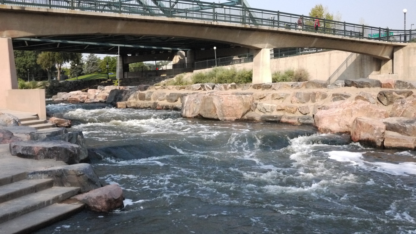
One of the first stops while exploring was Confluence Park, which is located at the northwest part of downtown Denver on the Platte River. Rocks were constructed to direct flow of the water to create rapids. Throughout the day, use of the site increased, ranging from kids, couples, and groups of bike riders. For more information on Denver parks please visit the website here.

After visiting the flagship REI store near by, began the trek to downtown to check another Lawrence Halprin design off the bucket list, and that would be Skyline Park.


This is quintessential Halprin, as expressed through his other west coast projects like Levi’s Plaza and Vaillan Court Fountain in San Francisco, and Keller Fountain Park in Portland, Oregon. Along the walk to the next destination there were more perennial beds.

In order to get to the capital building and its great lawn, one has to walk down the pedestrian-friendly 16th Street Mall. This almost curbless pedestrian-oriented street reminded me greatly of places like Barcelona’s La Rambla and Santa Monica’s 3rd Street Promenade.


Once at the end of the pedestrian mall, the capital building begins to reveal itself. Unfortunately at the time, the building’s dome was under construction.

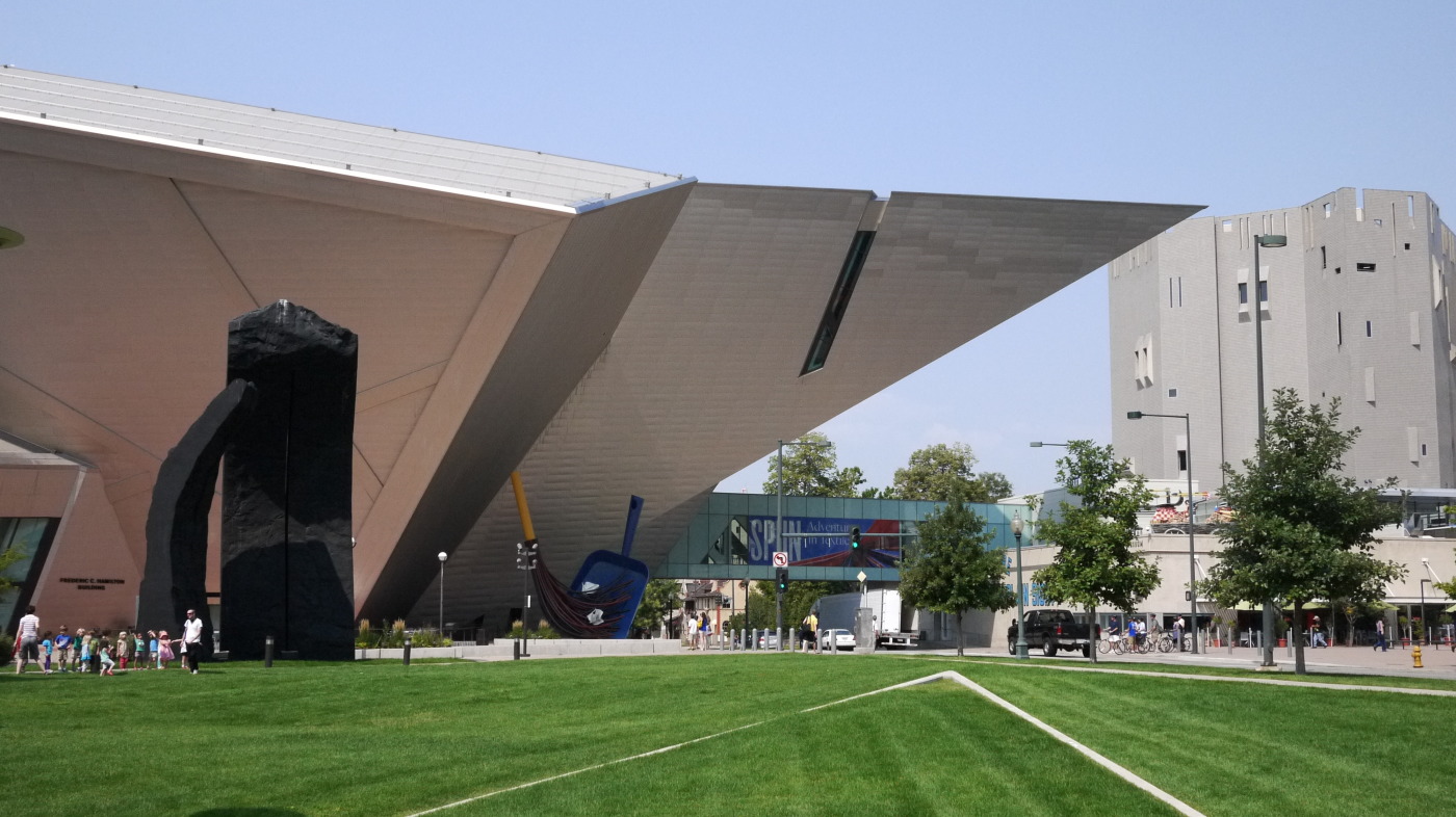
Near the capital is the Denver Art Museum with its space-like addition designed by architect Daniel Libeskind and an art sculpture by Claes Oldenburg & Coosje van Bruggen.

Over the course of the next few days, trips to the outlying towns were made and fun was had. One place high on the list of things to see was Red Rock Amphitheater near Golden. Truly an unbelievable landscape, albeit man-made, but you can’t take that away from the experience of being there for a concert or show. Its sheer scale is captivating.


Took a hike to Royal Arch and spent the day in Boulder. What a view from the top of Royal Arch to the landscape beyond. If you love hiking and the outdoors, its a must.


On the return trip, stumbled upon a makeshift Flinestone living room.

Last, but not least was the spectacular day trip to Garden of the Gods near Colorado Springs with Pikes Peak looming in the background.


Hopefully these images portray Colorado well and that it entices you all to explore its natural wonders. Happy exploring!


Part Three: Big Data to Big Design
Beautiful Golden Gate Park with the De Young Museum Observation Deck in the background
Landscape architecture is a multi-faceted field that requires its professionals to draw knowledge from all over. Those within the profession know that one can not be experienced or knowledgeable in one area alone. From soil science to plant botanical names to site planning and grading, those plying this trade need to know a lot about a lot of things.
In order to gain experience, designers, horticulturalists, and planners alike are now using data and statistical information to make stronger, more environmental, efficient designs. Thanks in large part to advances in technological devices, big data has become a by-product of that. Professionals in landscape architecture have been putting this data to work in many ways. The following are examples and case studies of how and where this is occurring.

The classroom allows students to explore all aspects of the profession, even the application of big data in landscape architecture
There is no place better to understand big data than in the classroom with hands-on experience. In 2012, President Obama passed an initiative that opened large amounts of previously withheld data. Along with that the administration more recently expressed the relevance of big data in our society by releasing it to the public. A benefactor of this is the University of Virginia. “The [Architecture] School manipluates large data sets, especially through visualization processes like GIS and BIM,” says School of Architecture dean Kim Tanzer. “We generate visual representations of data, useful in understanding quantitative information. And we use large data sets to design by prescribing data-driven parameters to inform design choices.” Furthermore, Tanzer continues by highlighting when landscape architects use different parameters illustrating how land areas might change as a result of different sea-level rise scenarios or how a neighborhood would change as a result of population growth or loss.
 Pedestrian crossing at San Bruno Ave in the Bay Area overlays topo lines at a 45 degree perspective
Continuing the trend of open sourced digital data, a recent ASLA interview with Suzanne Blier explains her work with WorldMap, a free GIS-based program that allows people to create their own maps with overlays filled with data for free. All of this would not be possible if it were not for the likes of satellite imagery sources, like USGS and Google Earth.
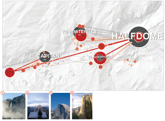
Graphic showing sight lines from photos taken on Flickr to views of Half Dome
GIS continues to show its importance in the profession. For example, in an article in the January 2013 issue of Landscape Architecture Magazine highlights the power of Flickr. Members of the popular photography website can geo-locate their photos, and that data has been analyzed to help better visualize sight lines to Half Dome in Yosemite. This technique could be applied to any data sets of images of a place geo-located on Flickr. Identifying sight lines though Flickr could help to improve land use/planning and the relationship between people, landscape, and the built environment.
 A classic: pen and paper sketches
A pen and paper has always been a designer’s best friend, but in the last 15 years or so, AutoCAD and its affiliated programs have allowed landscape architecture professionals to explore the profession and designs in greater detail. AutoCAD is no longer just about the 2D experience. Seeing designs in 3D is now the norm and we are getting instant feedback on designs with rigorous parameters. Along side that, the program Revit shows the nuts and bolts of how (in both 2D and 3D) architectural elements work with the landscape, like a project site’s topography with swales. From there, designers are using other programs like Maya and 3D Studio Max to bring projects to life through renderings and animations.
Big data sets can be applied to renderings to compare a site’s relationship with the elements of our environment and how it may change over time. And now AutoCAD also provides integration with GIS in its data mapping program Map 3D. With a plethora of software programs available to landscape architecture professionals, CAD’s ability to integrate multiple platforms and programs will always make it a designer’s new best friend.
 Rendering of a landscape design through Autodesk’s many programs
The future of landscape architecture is likely to combine tried-and-true intuition and design-sense with data-driven research. With astronomical amounts of data being generated every second, how might the profession evolve along side big data? This series has shed some light on what big data is and what impact it has on the process of design and landscape architecture. Big data plays a large role in our lives whether we acknowledge it or not. It is all around us.
Sources


Part Two: Big Data to Big Design
In Part One of this series we covered the surface of what big data is and its role in our daily lives. Part Two will start to look more closely at big data and its plethora of applications, most notably in the world of design. The above image is a design being printed on a 3D printer at Autodesk Gallery Design Night. An example of the design process becoming increasingly digital.
What do the cash register at the local grocery store, your friendly ATM machine, and your smart phone have in common, besides being electronic (and nonexistent as little as 20 years ago)? They are collectors of big data–and they usually do it without you even knowing. This data increasingly benefits the process of design.
Design, from product design to landscape architecture, is quickly becoming a digital experience as feedback is more and more often provided instantly. As we continue to rely on technology in the design process, it goes hand-in-hand with big data. Most if not all of the information that is considered big data comes from a digital source. An example would be software programs that use information to help designers better understand their environment in real-time, while another is your cellphone being used as a moving sensor. Known as crowd-sourcing, companies can tap into your mobile sensor, and provide information like traffic times and geographical information. Big data is helping us to design better products, places, and cities that function more efficiently.
This discussion about big data and design wouldn’t be complete without a mention of social networking sites. The ability to disseminate information to people all over the world has become so simple. Spotify, Pandora, Netlix, Facebook, Twitter, Flickr, Instagram, and other sites have become the bread winners in the realm of big data. Within each coded tweet, status update, and image posted, data is being crunched to help better solve human and environmental problems. This is where design can flourish.

Enter geographic information systems (GIS) and geodesign. The latter was a topic of discussion recently here on Land8. Check out 2 Books on Geodesign to read more. Of course the very ideas of Geodesign and GIS have a landscape architectural legacy. Ian McHarg, as early as 1964, envisioned that computers would one day manage his data overlays with great efficiency.

Overlays of information used in GeoDesign (Photo Credit: ESRI)
GIS is not itself “big data,” but it can use all this information being collected by phones and cardswipes and put it to work. Case studies conducted by GIS industry behemoth ESRI show that access to environmental and scientific data is more important than ever. This information allows us to make more critical decisions during the design process. A stable foundation of geographic and scientific information, says ESRI, “extends our analytical capabilities to automate the calculation of hazards, risk, sensitivity, capacity, proximity, accessibility, and other factors to inform design decisions.” Bringing technology, science, and analysis of statistical information into the design process has been a revelation, and all without compromising the art of design. GIS and big data together are helping to build and develop stronger designs.
A city that has implemented big data is Santander, in northern Spain. A program known as SmartSantander has major tech companies salivating. The city has placed some 12,000 hidden sensors across the city that measure everything from air pollution to locations of free parking spaces. Sensors monitor the city like a giant smart-home, and can let Santander personnel know which dumpsters are full, or can automatically dim street lights when no one is around. With information like this available, design of not only a city, but design of products on a human scale can evolve more quickly to better reflect the needs of people.

An aerial of Santander showing points of concern brought about by sensors (Photo Credit: NPR)
Design can’t occur without feedback from the user. So in closing, how can design research improve so the built environment and products of industrial design continue to improve? Its a question that may not have an answer at this time, but will be provided as time passes and new technologies and ideologies are developed. Over time, big data and design research can deepen our understanding of human behavior, interaction and preferences, bettering our designs and our ability to understand and predict their impact.
Next month Part Three will show the relationship of how big data is being implemented in the multi-faceted profession of landscape architecture. As always, let us know what you think. Leave a comment below…
Sources
Photo Credit: Livealoud


Part One: Big Data to Big Design
We live in a technologically driven society filled with bits of information and data. We are the causers, the makers of this data. A definition, provided by IBM:
Every day, we create 2.5 quintillion bytes of data — so much that 90% of the data in the world today has been created in the last two years alone. This data comes from everywhere: sensors used to gather climate information, posts to social media sites, digital pictures and videos, purchase transaction records, and cell phone GPS signals, to name a few. This data is big data.
The colorful image at top depicts word usage on Wikipedia, as users add text. IBM’s Visualization and Behavior Group create these diagrams as a way to visually process the information.
But what does it all mean? Do Facebook posts and Flickr pics actually tell us anything? This three-part series will consider those questions. Part One provides an introduction to big data, while Part Two explores the impact of big data in our society today with an emphasis on design. Finally, Part Three shows the relationship of how big data is or can be implemented in the multi-faceted profession of landscape architecture.
The process of translating large quantities of information and analyzing that data began most notably in 2000. Hal Varian, currently Google’s Chief Economist, started a process to study the amount of information flowing through Google searches. Searches and generated online histories are known as “digital breadcrumbs.” This trail of data that we all produce has proven to be profitable for businesses, politicians and governments, and numerous other market segments. Varian’s study ultimately created Google Trends, which shows the top searched items on Google. More importantly, it shows us the immense store of information (and power) that our digital lives create.
The internet, of course, has been a big reason for the increased growth of big data. When coupled with our ability to go mobile and remain connected to everything through our smart phones, tablets, and laptops, big data grew exponentially. With our lives on display through social media and the constant need to be connected, big data will continue to be a significant part of our lives, for better or worse.
As an example of the sheer amount of information that can be generated, see the infographic below, created by California-based company NetApp, talking about the most recent Summer Olympics in London:

With a general understanding of big data, we can start to see the magnitude of it and the role we play in creating this abundance of information. If you are wondering what this has to do with design and landscape architecture, the next two posts will focus at length on those areas. Check back soon for Part Two, as we delve into the multitude of design applications for big data.
Sources
- 1
- 2