

Beautiful Golden Gate Park with the De Young Museum Observation Deck in the background
Landscape architecture is a multi-faceted field that requires its professionals to draw knowledge from all over. Those within the profession know that one can not be experienced or knowledgeable in one area alone. From soil science to plant botanical names to site planning and grading, those plying this trade need to know a lot about a lot of things.
In order to gain experience, designers, horticulturalists, and planners alike are now using data and statistical information to make stronger, more environmental, efficient designs. Thanks in large part to advances in technological devices, big data has become a by-product of that. Professionals in landscape architecture have been putting this data to work in many ways. The following are examples and case studies of how and where this is occurring.

The classroom allows students to explore all aspects of the profession, even the application of big data in landscape architecture
There is no place better to understand big data than in the classroom with hands-on experience. In 2012, President Obama passed an initiative that opened large amounts of previously withheld data. Along with that the administration more recently expressed the relevance of big data in our society by releasing it to the public. A benefactor of this is the University of Virginia. “The [Architecture] School manipluates large data sets, especially through visualization processes like GIS and BIM,” says School of Architecture dean Kim Tanzer. “We generate visual representations of data, useful in understanding quantitative information. And we use large data sets to design by prescribing data-driven parameters to inform design choices.” Furthermore, Tanzer continues by highlighting when landscape architects use different parameters illustrating how land areas might change as a result of different sea-level rise scenarios or how a neighborhood would change as a result of population growth or loss.
 Pedestrian crossing at San Bruno Ave in the Bay Area overlays topo lines at a 45 degree perspective
Continuing the trend of open sourced digital data, a recent ASLA interview with Suzanne Blier explains her work with WorldMap, a free GIS-based program that allows people to create their own maps with overlays filled with data for free. All of this would not be possible if it were not for the likes of satellite imagery sources, like USGS and Google Earth.
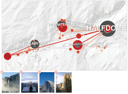
Graphic showing sight lines from photos taken on Flickr to views of Half Dome
GIS continues to show its importance in the profession. For example, in an article in the January 2013 issue of Landscape Architecture Magazine highlights the power of Flickr. Members of the popular photography website can geo-locate their photos, and that data has been analyzed to help better visualize sight lines to Half Dome in Yosemite. This technique could be applied to any data sets of images of a place geo-located on Flickr. Identifying sight lines though Flickr could help to improve land use/planning and the relationship between people, landscape, and the built environment.
 A classic: pen and paper sketches
A pen and paper has always been a designer’s best friend, but in the last 15 years or so, AutoCAD and its affiliated programs have allowed landscape architecture professionals to explore the profession and designs in greater detail. AutoCAD is no longer just about the 2D experience. Seeing designs in 3D is now the norm and we are getting instant feedback on designs with rigorous parameters. Along side that, the program Revit shows the nuts and bolts of how (in both 2D and 3D) architectural elements work with the landscape, like a project site’s topography with swales. From there, designers are using other programs like Maya and 3D Studio Max to bring projects to life through renderings and animations.
Big data sets can be applied to renderings to compare a site’s relationship with the elements of our environment and how it may change over time. And now AutoCAD also provides integration with GIS in its data mapping program Map 3D. With a plethora of software programs available to landscape architecture professionals, CAD’s ability to integrate multiple platforms and programs will always make it a designer’s new best friend.
 Rendering of a landscape design through Autodesk’s many programs
The future of landscape architecture is likely to combine tried-and-true intuition and design-sense with data-driven research. With astronomical amounts of data being generated every second, how might the profession evolve along side big data? This series has shed some light on what big data is and what impact it has on the process of design and landscape architecture. Big data plays a large role in our lives whether we acknowledge it or not. It is all around us.
Sources
Published in Blog