Blog

Geodesign the Solution for a Complex World

GeoDesign the solution

Nadia Amoroso, Director of Nadia Amoroso Studio and adjunct Professor in Practice, at University of Guelph shares with us her insights into Geodesign the solution. Cities around the world are striving to improve the quality of life for their citizens, creating great places to live where people can feel safe, healthy, happy and engaged in the community. Urban and regional planning plays a vital role in this effort as design of spaces, comprehensive planning, zoning regulations, creation and monitoring of special districts, multi-modal transit, enhancement of the public realm, historic preservation, permitting and overall design factors impact a community’s sense of place. These all affect the city’s vibrancy, sustainability and ability to flourish with changes over time. Planning has become complex and multi-layered, resulting in the need for multiple design programs and strategies.

Geodesign the solution

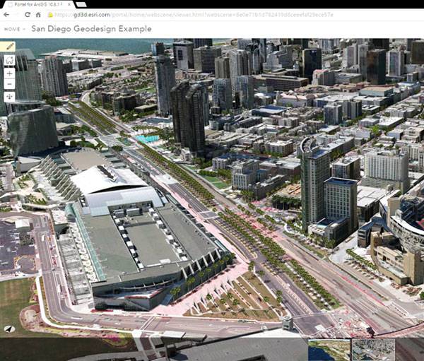
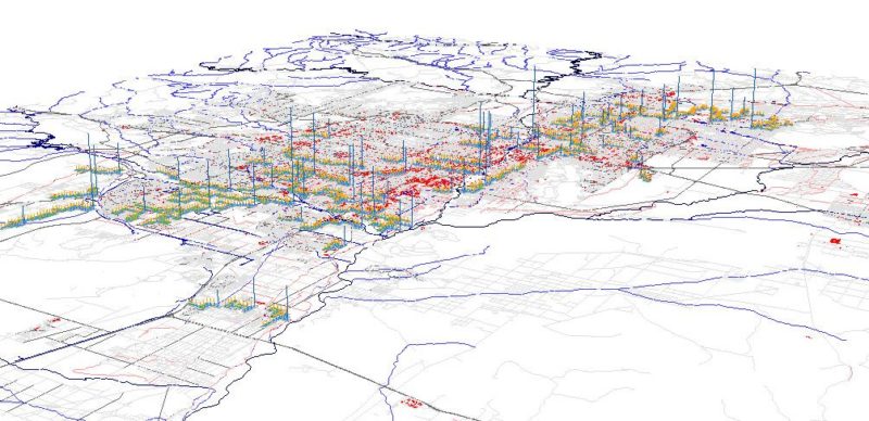
San Diego Geodesign Example – 3D Web Scene. Credit Esri Inc

Geodesign the solution

As designers of the built environment, we are faced with new challenges in the 21st century. Ensuring the safety and the resiliency of our private and public realm now involves complex issues such as managing storm water for cities and flood-prone areas, or designing transportation solutions to alleviate traffic congestion.These are large-scale issues requiring thoughtful analysis and creative solutions by planners, landscape architects, and urban designers. Geodesign is the solution to these complex problems. Geodesign takes geographic data and integrates it with GIS technology to create smarter, evidence-based planning and design. Geodesign helps planners envision the solutions needed to help solve complex environmental problems. It is a new way of thinking about the design process, taking site inventory and analysis to a whole new level by really understanding the location and the site through the integration of geographical data. Patterns are revealed, connections made and design decisions formulated with the help of key performance indicators.

GeoDesign the solution

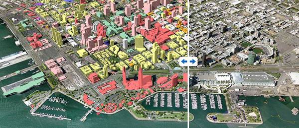
San Diego hypothetical design ideas- Side Swipe with Proposed Plan. Credit: Esri Inc

Geographic Information Systems technology (GIS) offered by Esri includes 2D and 3D design tools that incorporate data into the modeling and design process. Esri’s software solutions in support of the Geodesign framework include GeoPlanner for ArcGIS Online, ArcGIS Pro, and CityEngine. Together these three programs create an integrated platform, connecting with one another to provide specific outcomes and improve workflow efficiencies. The resulting design solutions can be shared with the public in a clear and understandable format.
GeoDesign the solution

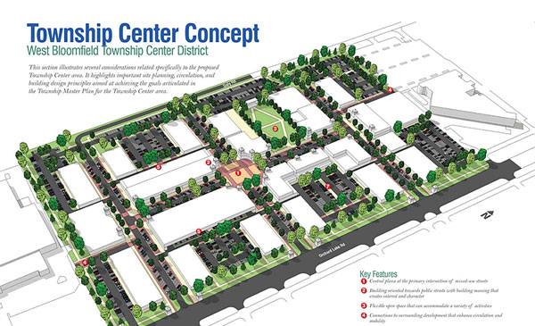
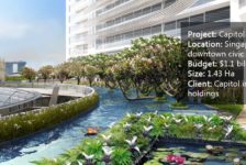
Click Here to see this image in full-size via our Pinterest page. This project by Houseal Lavingne Associate used CityEngine to generate buildings and the reporting in CityEngine was used to provide the gross leasable areas of the buildings. Credit by Houseal Lavinge Associates

An interesting point; Jack Dangermond, the founder and CEO of Esri Inc, is by training a landscape architect, having studied landscape architecture at Harvard’s Graduate School of Design. His dedication to environmental design and GIS has been seen in the successful global technologies he has developed throughout the decades. Now his commitment has been further amplified through the development of Geodesign technology, taking GIS to a whole new level as it is integrated with the design process. Esri Geodesign technology combines the power of site data with smart 3D modeling to help generate meaningful data visualization, test scenario impact simulations and communicate the story of a place. This technology aids landscape architects and designers of the built environment to really dive deep and understand the region or neighborhood in which they are working, enabling them to interpret data and leverage existing conditions to create an intelligent design. The resulting parametric and evidence-based designs give designers great credibility, as their decisions are backed by solid data.
GeoDesign the solution

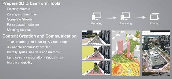
Design and Visualize Scenarios, effectively with Esri’s software solutions in support of the Geodesgin framework. Credit: Esri Inc.

In this way, Esri’s software solution in support of Geodesign is similar to a BIM for urban design and planning. Much of the value of Geodesign technology lies in real – time feedback. When changes are made to a design, there is instant reporting of the data connected to the new solution. The impacts of the designs are assessed against specific indicators. In a recent webinar, entitled “How Geodesign is Busy Envisioning and Engaging with Your Neighborhood”, Brooks Patrick, one of the leaders of the Geodesign team at Esri, spoke about the value and importance of Geodesign in urban design and planning/ landscape architecture. Devin Lavigne, the principal at Houseal Lavigne Associates, a landscape architecture, and urban design firm, contributed his thoughts on the importance of the Geodesign process. The new technologies, particularly CityEngine, have enabled him to work quickly and efficiently, cutting the time needed to model, detail, render and export by almost half. The Geodesign framework allows for collaborative feedback from stakeholders, clients, and other members of the project team, enabling the creation of in-depth designs by allowing inputs and exploration from many points of views. Designs and stories can be exported to a 3D web scene and made available to the public or a select group within an organization. With input from all stakeholders, designers are able to make intelligent and highly informed decisions, resulting in a successful design for the community. Check out the webinar (below) for more information on the value of Geodesign and to find out the many ways Esri technology works with it to improve urban design and landscape planning. Case study examples are provided. WATCH:  Learn How Geodesign is Busy Envisioning and Engaging with Your Neighborhood

Also, check out this Gedesign Story map on the web To learn more about the Geodesign approach and technology- click here and download free trials of GeoPlanner, ArcGIS Online, CItyEngine and ArcGIS Pro. Books by Nadia Amoroso:

Article by Nadia Amoroso, PhD, ASLA Return to Homepage

Published in Blog

Leave a Reply

Lost Password

Register