


Author: BimDjSoftech


The Sensational Hive Project by World Renowned Grant Associates
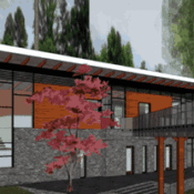
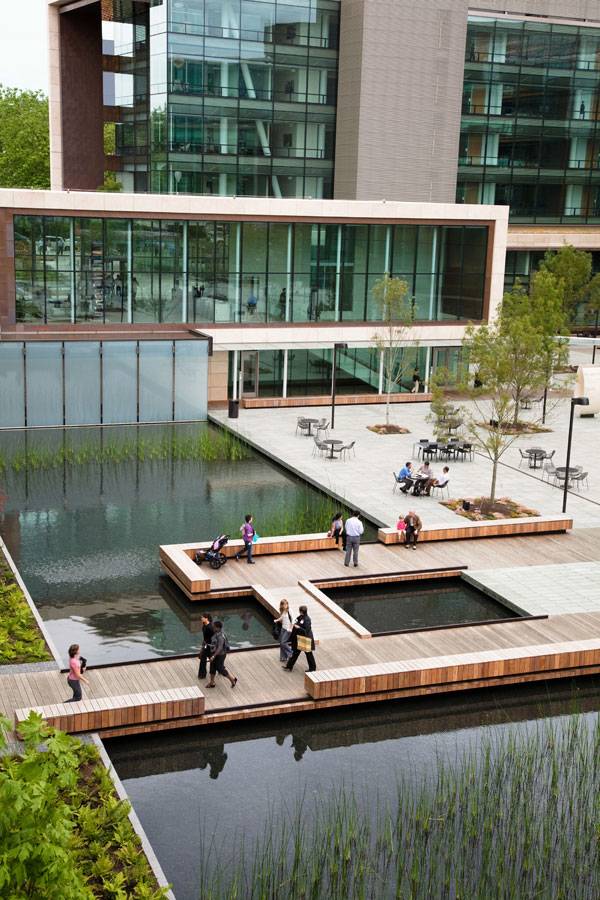
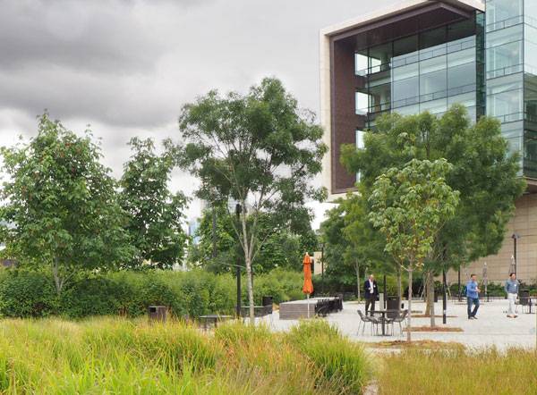
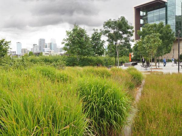
The Hive by Grant Associates, in Worcester, UK. In the world of landscape architecture, sustainability has become a standard that most designers aspire to. It’s a practice that is even more important in today’s growing world than ever before and can be found in almost every press release for every major new project. And what better symbol to use for a sustainable project than that of a beehive, something that sustainable practices will hopefully help to preserve for future generations. Located in Worcester, UK, The Hive, a “BREEAM Outstanding” project, is home to the first joint university and public library – a venture between the City of Worcester and its University. The project was 10 years in the making and the result is a destination that invites learning both inside and out.

Photo credit: The Hive Worcester Library

Photo credit: The Hive Worcester Library
What was the mission for Grant Associates?
The Worcester City Council also hired Grant Associates, a British Landscape Architecture consultancy, to design the outside of the building, with instructions “to create a high quality landscape environment that would become a distinctive and exciting visitor attraction – a place which would capture a sense of history and place whilst reflecting on the contemporary themes of sustainability and technological innovation.”

Photo credit: The Hive, Worcester – Grant Associates

Photo credit: The Hive Worcester Library
- Lotus Lake Park Sets Precedent for Sustainable Urban Design in China
- Contemporary Landscape Architecture in China: Beautiful or Dangerous?
- Awesome Plaza Shows You Why China Are World Leaders in Landscape Architecture

Photo credit: The Hive Worcester Library

Photo credit: The Hive Worcester Library

Photo credit: The Hive Worcester Library

Photo credit: The Hive Worcester Library
- Urban Design by Alex Krieger
- The Urban Design Handbook: Techniques and Working Methods (Second Edition) by Urban Design Associates
Article by Erin Tharp Return to Homepage


Street Design: The Secret to Great Cities and Towns | Book Review
Street Design: The Secret to Great Cities and Towns, by Victor Dover and John Massengale. Published by Wiley, 2014. 401 pages. At the heart of every successful city design is successful street design. And by that, it is not meant that the city is home to a variety of interstates and highways moving people to and fro. It means that the city is home to livable streets that people want to experience, not just drive on. The book Street Design: The Secret to Great Cities and Towns, by Victor Dover and John Massengale, along with a number of guest essayists, seeks to reveal the secrets behind what makes a great street and thus a great city.
Street Design: The Secret to Great Cities and Towns

Front cover. Street Design: The Secret to Great Cities and Towns. Photo credit: Erin Tharp

Inside. Street Design: The Secret to Great Cities and Towns. Photo credit: Erin Tharp

Inside. Street Design: The Secret to Great Cities and Towns. Photo credit: Erin Tharp

Inside. Street Design: The Secret to Great Cities and Towns. Photo credit: Erin Tharp

Inside. Street Design: The Secret to Great Cities and Towns. Photo credit: Erin Tharp
Pick up your copy of Street Design: The Secret to Great Cities and Towns
Review by Erin Tharp Return to Homepage

SketchUp for ipad: The Essential Guide
A deeper look at the possibilities of using SketchUp for ipad. SketchUp is known for being the most user-friendly 3D modeling software on the market. Add that to its compatibility with CAD and other drafting software, and there really is no reason why offices shouldn’t use it. And now, with two new SketchUp Apps for Apple iPad, the accessibility of the program has grown.
SketchUp for ipad
The first app, called “SketchUp Mobile Viewer,” was developed by Trimble Navigation Limited. It allows users to explore and share millions of free 3D models in the 3D Warehouse from their iPads.

SketchUp for iPad, see the features HERE!
- Top 10 Hints & Tips For SketchUp
- 3D Modeling Software for Landscape Architects
- Computer Aided Software for Landscape Architects: The Essential Guide
The Downside The only downside seems to be that in order to view one of your own projects created with actual SketchUp, you must first download it to the 3D Warehouse, which many design professionals might not want to do if it’s a project designed for a particular client. The app will not let you build a model, so while the $9.99 pricetag might seem like a great deal compared to the one for SketchUp Pro, it’s really more of a viewer than a modeling app. Disaster: There’s an app for that! Most users that purchased it weren’t happy, and reviews on Apple’s iTunes store received two stars at most. Some quotes were, “Not very flexible or usable for professionals,” “Should have waited longer until it developed more,” and “Wish there were zero stars.” One user went so far as to question why Apple even allows the app to stay in its store. Bonus Video: Guide To Sketchup Viewer The second app is called “Shortcuts for GoogleSketchUp” and was developed by Nikolay Smorgun and is essentially a digital cheat sheet for SketchUp shortcuts. Users are asked to choose their platform, either Mac or Windows, and from there choose from the “Main Menu,” “Tools,” and “Canvas.” From there, it’s simply a list of commands and the keyboard shortcuts associated with the commands. For example, the Pan command is “Shift+scroll MMB.” Extras or advertisements? In addition to the SketchUp shortcuts, the app also contains links to Google News, the local weather, and the Bloomberg web page.
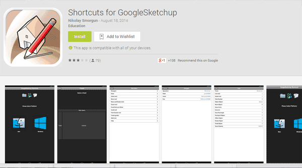
Shortcuts for GoogleSketchup. Learn more HERE!
Is this a five star SketchUp for ipad app. ?
On the iTunes app store, one user wrote, “This app will save you countless hours with learning the shortcut keys alone. I’ve spent 20 minutes (off and on) this app and have already noticed an increase in my design time efficiency. In the words of Colin Chapman, ‘Simplify, and add lightness.’ This app clearly exemplifies that quote. It’s fast because it’s simple. All of the necessary information is close at hand. Thanks!” The user also gave the app the highest rating, five stars. Bonus Video: View Your 3D SketchUp Designs on the iPad in 3 Simple Steps The best thing about this app is its price — it’s free, with no in-app purchases required. It is also compatible with iPhone, iPad, and iPod Touch and is optimized for the iPhone 5. So, in the end, it appears that there really is only one Google SketchUp, and that’s the program for actual computers. The good thing is that Google will let you download a trial program of SketchUp Pro to try for free for 30 days. After that, users can purchase a lifetime license for $590. There are also discounts available for students and educators, and a free version — SketchUp Make — that is not intended for commercial use, but still can be used to create 3D models and gives users access to the 3D Warehouse. Recommended Reading:
- SketchUp 2014 For Dummies (For Dummies (Computer/Tech) by Aidan Chopra
- SketchUp 2014 for Architectural Visualization by Thomas Bleicher
Article by Erin Tharp Return to Homepage

20 Million Euro Investment in Urban Waterfront Regeneration Pays Off at the Ljubljanica Embankment in Slovenia
Pavilion at the Ljubljanica Embankment, BB Arhitekti, Ljubljana, Slovenia For hundreds of years, European cities relied on the rivers they were built around for transportation and for sending and receiving goods. In the modern world, these rivers have become novelties or tourist attractions, and locals have become out of touch with the grand bodies of water that helped form their cities. Such was the case for the Ljubljanica River in Slovenia until the city dreamed up a way to reconnect the people to the river.
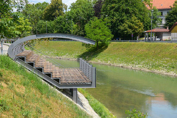
Photo Credit: Pavilion at the Ljubljanica Embankment, by BB Arhitekti by Dunja Wedam
Urban Waterfront Regeneration to Fulfill Jože Plečnik’s Dream
The riverbank had not been touched since the 1930s, when the architect Jože Plečnik defined the river with his monumental buildings, open squares, canals, embankments, and riverside parks. Plečnik envisioned the river as the center of the city and sought to transform Ljubljana into a cultural center. But by the 21st century, his vision had died. The river lacked modern infrastructure, and the car had become the primary means of transportation, tarnishing the allure of his walkable city. Those changes, combined with a decline in businesses due to urban sprawl, left the city in desperate need of help.
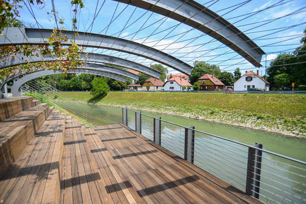
Photo Credit: Pavilion at the Ljubljanica Embankment, by BB Arhitekti by Dunja Wedam
20 Million Euro Investment in Urban Waterfront Regeneration
So city officials stepped in with a plan to rebuild the city. In 2004, Ljubljana City Council decided to invest more than 20 million euros to rebuild the riverbank, with the hope that the city would experience an economic and social revival. One of the interventions included a steel pavilion that was mounted at the Petkovškovo embankment as a temporary public space meant to reconnect the city’s street level — and pedestrians — to the river. The new public space was also meant to serve as a social experiment to test the responses of people to such a space and to the river.
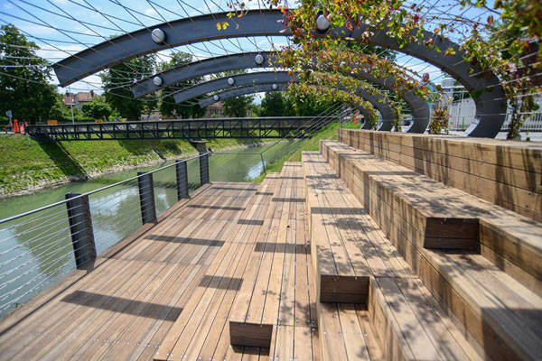
Photo Credit: Pavilion at the Ljubljanica Embankment, by BB Arhitekti by Dunja Wedam
- Top 10 Reused Industrial Landscapes
- Community Turn Abandoned Industrial Site into Public Park
- Industrial Site Transforms into Beautiful Landscape
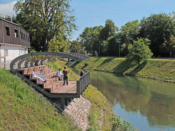
Photo Credit: Pavilion at the Ljubljanica Embankment, by BB Arhitekti by Saša Pančić
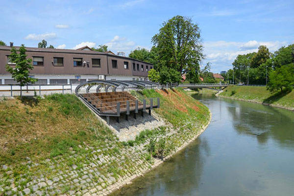
Photo Credit: Pavilion at the Ljubljanica Embankment, by BB Arhitekti by Dunja Wedam
- Urban Design by Alex Krieger
- Digital Drawing for Landscape Architecture by Bradley Cantrell
Article by Erin Tharp Return to Homepage

The Stunning Yanweizhou Park Recaptures Lost Ecology
An Exclusive review of Yanweizhou Park by Turenscape, in Jinhua City, Zhejiang Province, China. In the Chinese culture, water is one of the five elements – the other four being metal, wood, fire, and earth – but water is one that is held especially close. One theory is that due to China’s mountainous topography, Chinese cities were built in the valleys close to the many rivers that flow through the land. For this reason, the Chinese people came to view the rivers as the heart and lifeblood of their culture. So, it comes as no surprise that the latest Turenscape project, Yanweizhou Park, is built around not one, but three rivers.

Yanweizhou Park, before and after pictures. Credit: Turenscape
Location of Yanweizhou Park
Yanweizhou Park is located in Jinhua City where the Yiwu River, Wuyi River and Wujiang River converge. At more than 250,000 square meters and carrying a price tag of more than RMB 300m, this a truly a magnificent addition to both the social and ecological Chinese landscape.

Pavilion at Yanweizhou Park. Credit: Turenscape

Yanweizhou Park, birdseye view. Credit: Turenscape
What Professor Yu Kongjian has to say about Yanweizhou Park
“My mother river, the Baishaxi Stream (a major tributary of the Wujiang River), is not a simple stream but an ecological infrastructure. It provides essential supplies, it carries of lives, culture, aesthetics, and enlightenments for people throughout the watershed. It is a social infrastructure, an experienced network, and a carrier for the endless memoires. All of these have inspired me the solution to rehabilitate her: Rebuilding society, as rebuilding ecology, should start with the rehabilitation and construction of these essential ecological infrastructures,” he wrote for Turenscape shortly after completion of the park.

Terrace at Yanweizhou Park. Credit: Turenscape

Yanweizhou Park. Credit: Turenscape

“40,000 visitors each day”. Credit: Turenscape
- Turenscape Design Outstanding River Park
- Shipyard Site Transforms into Stunning Ecological Park
- Fantastic River Park Unveils the Value of the Natural Landscape

Terrace at Yanweizhou Park. Credit: Turenscape

Seating at Yanweizhou Park. Credit: Turenscape

Seasonal flooding at Yanweizhou Park. Credit: Turenscape
- Urban Design by Alex Krieger
- Digital Drawing for Landscape Architecture by Bradley Cantrell
Article by Erin Tharp Return to Homepage


Digital Drawing for Landscape Architecture, second edition | Book Review
Digital Drawing for Landscape Architecture: Contemporary Techniques and Tools for Digital Representation in Site Design second edition – Bradley Cantrell and Wes Michaels, published by John Wiley & Sons, 2005. Paperback, 317pgs. In today’s technological society computer programs and design seem to go hand in hand, but in a profession that once revered the art of hand drawing, or analog design, new technology can be hard to embrace, much less learn. Authors Bradley Cantrell and Wes Michaels, both working landscape architects, realize this and in Digital Drawing for Landscape Architects attempt to bring readers up to date with some of the latest and greatest computer-aided drafting software.
Digital Drawing for Landscape Architecture

Photo credit: Erin Tharp

Photo credit: Erin Tharp
Digital Drawing for Landscape Architecture Focus
There are five parts to the book and in part one, Concepts, chapter two sets up the premise of the book through an excellent comparison of analog and digital rendering. Chapter three goes on to give a basic overview of digital concepts, which might make it the most informative chapter in the book as it goes through and explains and defines the basic concepts that are associated with almost every digital program, which are helpful to even the most seasoned designer. After discussing workflows in part two, which includes base imagery and scaling in chapter six, the book moves into the more intricate, and sometimes, mundane details of a design, including managing large files and even printing issues.

Photo credit: Erin Tharp

Photo credit: Erin Tharp
- Drawing for Landscape Architecture
- Detail in Contemporary Landscape Architecture
- Visual Communications For Landscape Architecture
At slightly over 300 pages, this is the second edition of this ASLA award-winning book and it includes over 50 new examples with updated graphics to highlight the newest applications. When it was first published in 2012, the book was awarded an ASLA Award of Excellence based on its ability to “provide context for how we use digital media as designers and landscape architects,” so check it out and start the process of becoming an expert in digital rendering.
Pick up your copy of Digital Drawing for Landscape Architecture
Review by Erin Tharp Return to Homepage

Top 10 World Class Landscape Architecture Projects of 2014
10 Outstanding Landscape Architecture Projects of 2014. Every year, the world becomes home to new, innovative projects in landscape architecture. And every year, the designers behind these projects eagerly await recognition for their hard work. Looking at new technology, public attitudes toward the space, and awards received, the following list is a showcase of some of the best of 2014.
Landscape Architecture Projects of 2014
10. Segment 5, Hudson River Park, A Resourceful and Resilient Space for a Park-Starved Neighborhood, New York, NY – Michael Van Valkenburgh Associates Segment 5 is quickly becoming the most popular spot in the former “parkless” New York City neighborhood of Chelsea. This was no mistake: Designers worked closely with neighborhood residents to develop a plan that met their needs, as well as those of the state and the city. The site boasts a three-acre lawn, where pickup sports and outdoor yoga classes are a common occurrence, and participants are sheltered from the West Side Highway by the dramatic landform bowl. WATCH: Hudson River Park: A New York Treasure 9. Sherbourne Common, Toronto, Ontario — Phillips Farevaag Smalleberg As a winner of the 2013 ASLA Honor Award for Design, this space has been around for more than a year. However, it continued to make headlines throughout 2014. Sherbourne Common, a formerly neglected brownfield site on Toronto’s waterfront, combines a storm water treatment facility with landscape, architecture, engineering, and public art to provide an outdoor living room for the new residents of the East Bayfront community. WATCH: Grand Opening of Sherbourne Common North 8. Hunter’s Point South Waterfront Park, Queens, NY – Thomas Balsley Associates and Weiss/Manfredi This site is surrounded by water on three sides and offers a spectacular view of the Manhattan skyline across the East River. Two hundred years ago, the site was a series of wetlands, but eventually was overtaken by industry. Designers were asked to combine these two aspects by using landscape architecture, architecture, and engineering to create a space that would use sustainability to blur the lines between infrastructure and landscape.
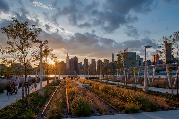
Hunter’s Point South Park. Photo credit: Wade Zimmerman
Laurance S. Rockefeller Preserve. Photo credit: HERSHBERGER DESIGN
- Top 10 World Class Landscape Architecture Projects of 2013
- 30 Landscape Architecture Firms To Keep Your Eye On!
- 10 Great Places to Study Landscape Architecture in Europe
The Park at Lakeshore East, Chicago, IL. Credit: The Office of James Burnett

Vanke Architecture Research Center (VARC) . Photo credit: Hai Zhang

Poppy Plaza. Photo credit: Brian Shier
Liupanshui Minghu Wetland Park, Liupanshui, Guizhou Province, China – Turenscape

Credit Timothy Hursley
Credit: TCL – Canberra Arboretum. Photo credit: John Gollings
- Urban Design by Alex Krieger
- Digital Drawing for Landscape Architecture by Bradley Cantrell
Article by Erin Tharp Return to Homepage
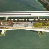

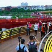
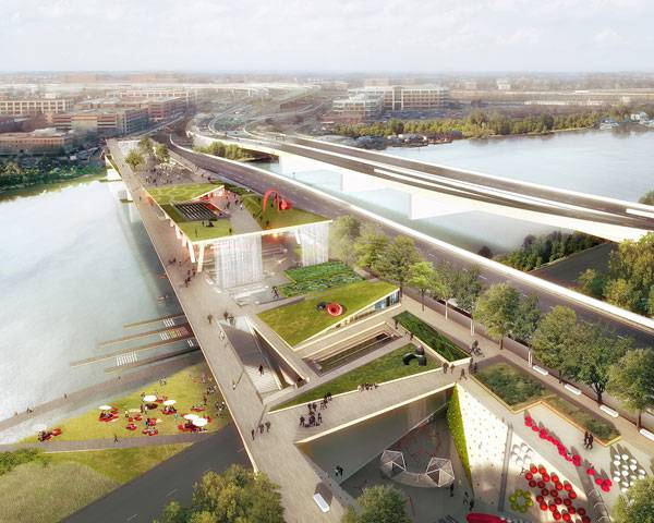
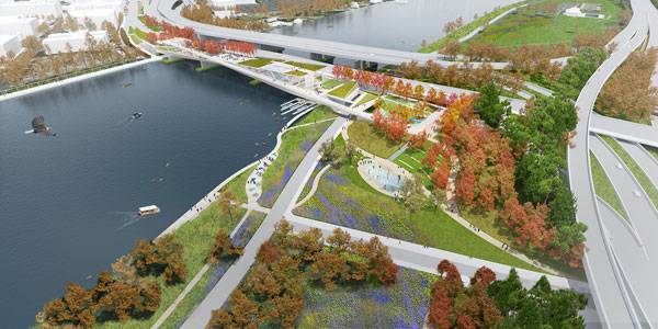
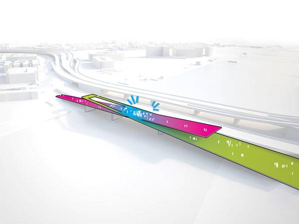
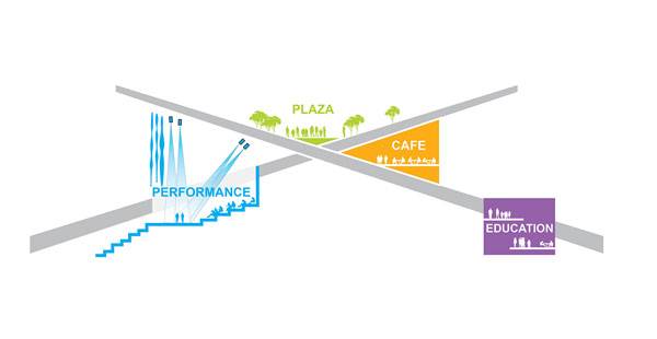
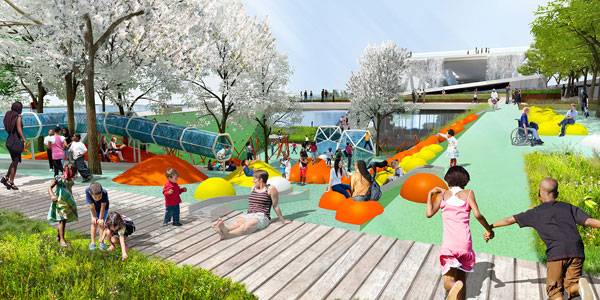
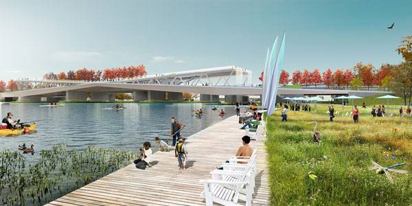
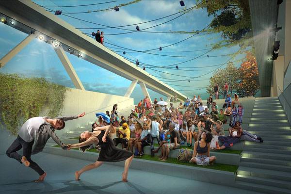
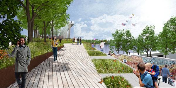
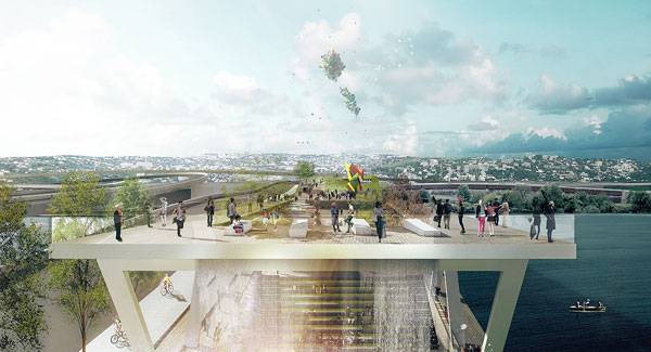
The Street Bridge Park Everyone’s Talking About
11th Street Bridge Park, OMA + OLIN design, Washington, D.C. In metropolitan areas, land comes at a premium and outdated infrastructure can be abundant, so when Washington, D.C., was seeking a plot of land on which to install a new civic space, the city decided to host a competition to transform an aged-out freeway bridge over the Anacostia River. At the end of the seven-month competition, the unanimously winning team for the 11th Street Bridge Park was OMA + OLIN design. “The 11th Street Bridge project is a special precinct in the structure of the city,” said competition juror Harry G. Robinson III, FAIA, professor of urban design and dean emeritus at Howard University. “It is at once both a crossing and a place. In its purest role, it is a hyphen that connects and celebrates the physical and cultural histories of two historic and vibrant Anacostia shoreline communities, while establishing a civic expression of democracy.”
The Street Bridge Park
Credit: © OMA and OL
Credit: © OMA and OLIN
Credit: © OMA and OLIN
© OMA and OLIN
© OMA and OLIN
© OMA and OLIN
© OMA and OLIN
© OMA and OLIN
© OMA and OLIN
- Site Engineering for Landscape Architects by Steven Strom
- The Artful Garden: Creative Inspiration for Landscape Design by James van Sweden
Article by Erin Tharp Return to Homepage

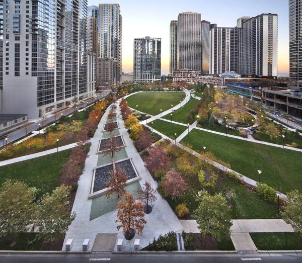
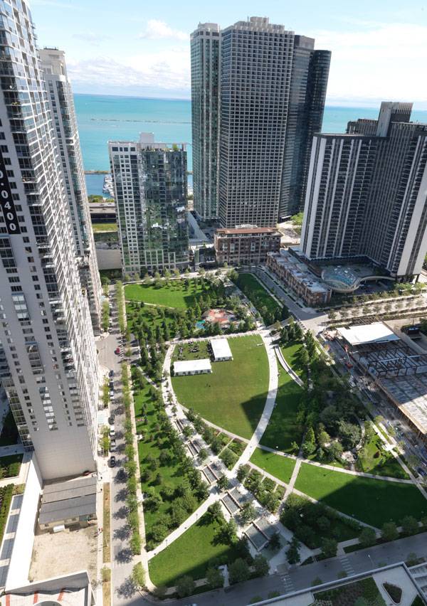
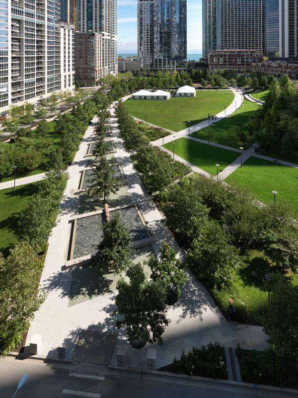
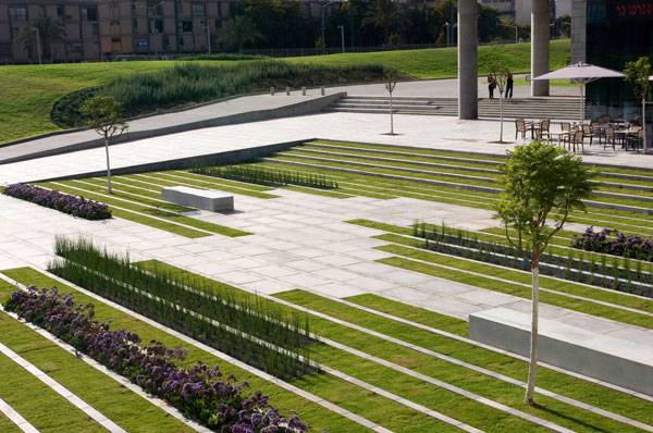
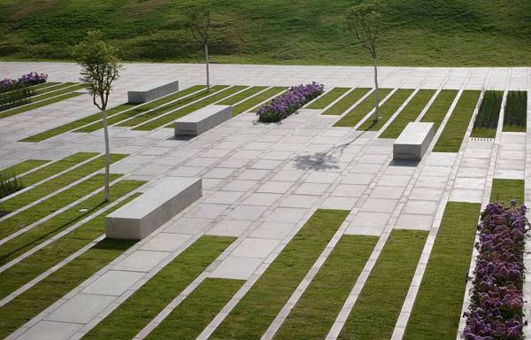
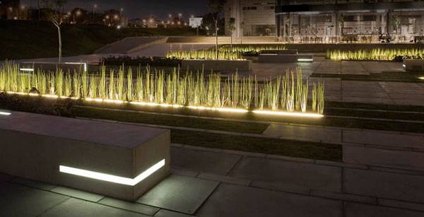
Is This Park Design a Rival for the Famous Millennium Park?
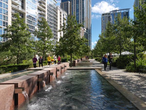
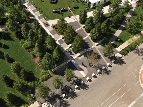
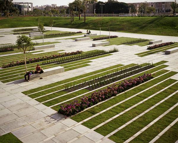
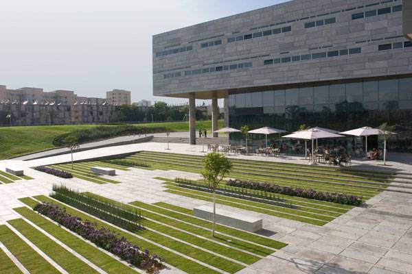
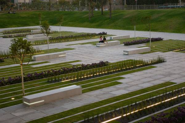
The Park at Lakeshore East, Chicago, IL, by The Office of James Burnett. Chicago’s Park at Lakeshore East is making a name for itself as a rival to the city’s famous Millennium Park. Since being dedicated in 2005, The Park at Lakeshore East is now not only a part of the Chicago Park District, but has also been nicknamed the “village in the heart of the city” by local developers. The 5.3-acre park was designed by The Office of James Burnett of Houston, Texas. The firm, founded in 1989, has amassed a vast profile and says that “Landscape design is their passion – it is who they are, not just what they do – and that passion is reflected in the spaces they create.” The firm was hired early in the project to aid the master plan architects, and also helped to produce the open space guidelines that would later be used in the design and development of the park.
The Park at Lakeshore East, Chicago, IL. Credit: Steinkamp Photography
The Park at Lakeshore East, Chicago, IL. Credit: Steinkamp Photography
Sail Boat Inspired Park Design
At first glance, the central feature would be the two sweeping promenades, designed to mirror the sails of the boats that can be seen in the nearby harbor. These promenades serve as the primary circulation across the site. Fountain basins, seating areas, and ornamental gardens can be found alongside each, promoting leisurely strolls and quiet reflection.
The Park at Lakeshore East, Chicago, IL. Credit: Steinkamp Photography
- Historical Landscape Gets Modern Day Makeover
- 15 Great Examples of Historical Landscape Architecture
- 30 Landscape Architecture Firms To Keep Your Eye On!
The Park at Lakeshore East, Chicago, IL. Credit: Steinkamp Photography
The Park at Lakeshore East, Chicago, IL. Credit: Steinkamp Photography
- Urban Green: Innovative Parks for Resurgent Cities by Peter Harnik
- Urban Parks and Open Space by Alexander Garvin
Article by Erin Tharp Return to Homepage

Elegant Square Sets the Stage for University Students
Ben-Gurion University University Entrance Square & Art Gallery, by Chyutin Architects, Beer-Sheva, Israel. Ben-Gurion University, in the Israeli city of Beer-Sheva, is home to the new meditative Deichmann Square that is bringing hope for the future back to a city that is constantly on the verge of losing it. The 3,500 square-meter space incorporates hardscapes and plantings almost seamlessly, while also shining a light on future development, not only on campus, but also in Israel. Located in the western part of the BGU campus, the square is adjacent to existing buildings and the future Negev Gallery, and is meant to serve as a link between the community and the art and social sciences studied in the buildings. This connection is emphasized by a pedestrian path that leads to a city square and then on to the entrance gate of the university, welcoming those from the outside to come in and find solace.
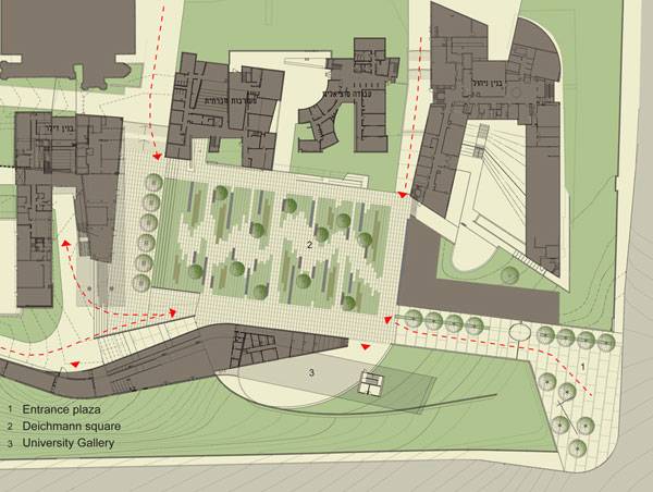
Plan of BGU University Entrance Square & Art Gallery. Image credit: Chyutin Architects Ltd.
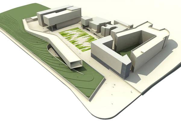
Digital 3D model of BGU University Entrance Square & Art Gallery. Image credit: Chyutin Architects Ltd.
Deichmann Square a Place for University Students
This can be found in the Deichmann square where concrete and vegetation weave together as if in an homage to the Israeli landscape, where large cities lie amongst rolling hills and mountains. They write that their team strives to adhere “to the homeland’s landscapes: to its inanimate matter, to its vegetation, and to its color that is revealed by the blazing sun.”
BGU University Entrance Square & Art Gallery. Photo credit: Sharon Yeari
BGU University Entrance Square & Art Gallery. Photo credit: Sharon Yeari
BGU University Entrance Square & Art Gallery. Photo credit: Sharon Yeari
- 10 Great Places to Study Landscape Architecture in the USA
- 10 Great Places to Study Landscape Architecture in Europe
- X-Section Interview- University Magazine for Landscape Architecture
Students hanging out at BGU University Entrance Square & Art Gallery. Photo credit: Sharon Yeari
BGU University Entrance Square & Art Gallery. Photo credit: Sharon Yeari
BGU University Entrance Square & Art Gallery. Photo credit: Sharon Yeari
- Landscape Architecture: An Introduction by Robert Holden
- Detail in Contemporary Landscape Architecture by Virginia McLeod
Article by Ern Tharp Return to Homepage


How Industrial Landscapes Can Become Beautiful Sites
Haute Deûle River Banks by Atelier de Paysages Bruel-Delmar. The French landscape often provokes images of chateaus, rolling hills of lavender, cities comprised of ornate and delicate buildings and, of course vineyards, but these images are not often of industry. But this may soon change with the revitalization of the Haute Deûle River Banks and the old textile mill that had been left to deteriorate until now. Atelier de Paysages Bruel-Delmar – a team of city planners & landscape architects, were commissioned by SORELI for the cities of Lille and Lomme and the urban community LMCU to design all the public spaces and the lift bridge, and their design takes into account the history of the site while integrating modern day technology and design aesthetics to create a functional and welcoming space.

Masterplan. Credit: Atelier de Paysages Bruel-Delmar
Water garden and wet grassland. Credit: Atelier de Paysages Bruel-Delmar

Connecting business with nature in the water Garden. Photographer: Yves Bercez
The Impact of Water in the Industrial Landscape
The water takes center stage here and the designers describe its presence as “undeniable, as much in the district history as in its present-day configuration, despite a loss of recognition.”
WaterGarden – First year. Credit: Atelier de Paysages Bruel-Delmar

WaterGarden + Euratechnoly. Credit: Atelier de Paysages Bruel-Delmar

Water Garden + Euratechnoly. Credit: Atelier de Paysages Bruel-Delmar
Water garden in bloom. Credit: Atelier de Paysages Bruel-Delmar
- Top 10 Reused Industrial Landscapes
- From Rubble to the Ritz – Revitalizing Abandoned Sites
- Industrial Site Transforms into Beautiful Landscape
Water garden in the summer. Credit: Atelier de Paysages Bruel-Delmar

Water garden + Iron footpath. Credit: Atelier de Paysages Bruel-Delmar
Lift Bridge. Credit: Atelier de Paysages Bruel-Delmar
Planting up roadsides. Credit: Atelier de Paysages Bruel-Delmar
Credit: Atelier de Paysages Bruel-Delmar
Jumping into the canal. Credit: Atelier de Paysages Bruel-Delmar
- Principles of Ecological Landscape Design by Travis Beck
- Design with Nature by Ian L. McHarg
Article written by Erin Tharp Return to Homepage


How to Study for the L.A.R.E. – The Essential Guide
Studying for the L.A.R.E. by LAN writer Erin Tharp who has recently passed the L.A.R.E. For future landscape architects, seeking initial licensure can seem like a daunting task, but by adhering to the following advise, at least the Landscape Architecture Registration Exam (L.A.R.E.) won’t seem so scary. But, before the studying begins, be sure to start a council record with the Council of Landscape Architectural Registration Boards (CLARB) and check with the state administering the exam, most have graduation and work requirements before one is allowed to sit for the L.A.R.E. So, you’ve met all of the requirements and now you’re ready to take the test, or are you? The L.A.R.E. consists of four computerized sections, and according to CLARB’s website is “designed to determine whether applicants for landscape architectural licensure possess sufficient knowledge, skills and abilities to provide landscape architectural services without endangering the health, safety and welfare of the public.”
The Main Sections of the L.A.R.E.
Section one is titled “Project and Construction Management,” two is “Inventory and Analysis,” three is “Design,” and section four is “Grading, Drainage and Construction Documentation.” While all of these may sound like topics covered in your degree program, more than likely they weren’t. And forget the pretty pictures, since the test is computerized you are not being tested on your design aesthetics, you are being tested on health, safety, and welfare. So, how do you study? First off, CLARB sells practice exams for each test, buy these, they will prove integral to your studying. The questions on the practice tests will probably not show up on the actual exams, but they will give you a clue about what to study and will also show you the format of the exams. When taking the practice exams, look for key words, such as watershed, and then learn everything you can about watersheds and what a landscape architect would need to know about a watershed as applied to health, safety, and welfare of the public. The Book List
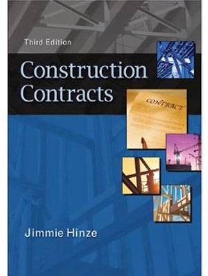
LARE reading list: Construction Contracts by Jimmie Hinze
- Construction Contracts by Jimmie Hinze
- Basic Elements of Landscape Architectural Design by Norman K. Booth
- Landscape Architectural Graphic Standards by Leonard J. Hopper
Article written by Erin Tharp Return to Homepage Featured image: Studying: Public Domain by Gnarlycraig