


Author: Land8: Landscape Architects Network

Reflecting on the Past for a Better Future
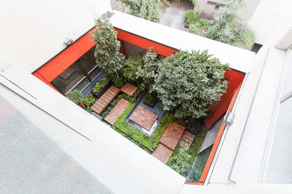
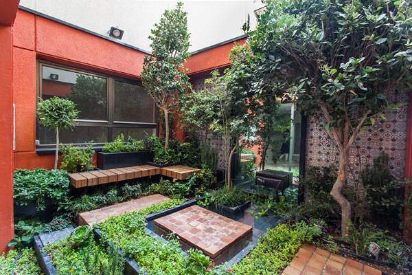
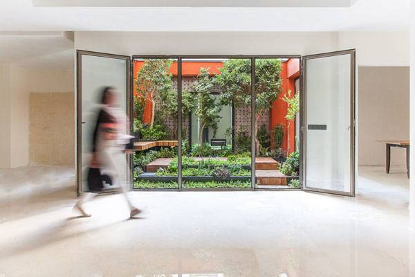
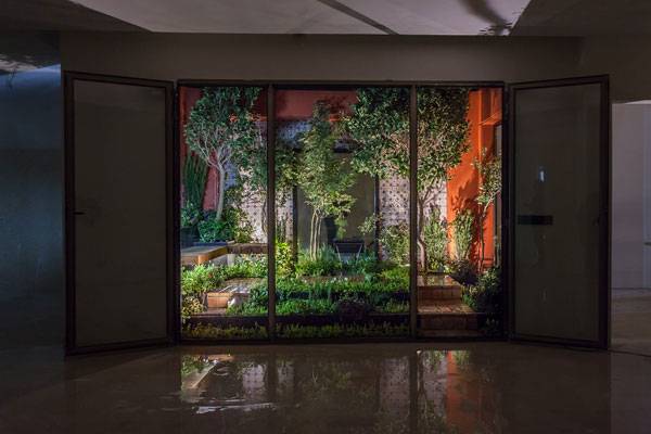
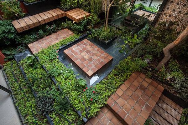
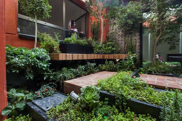
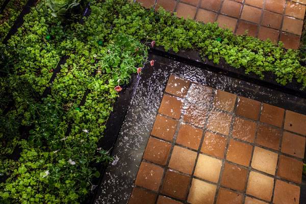
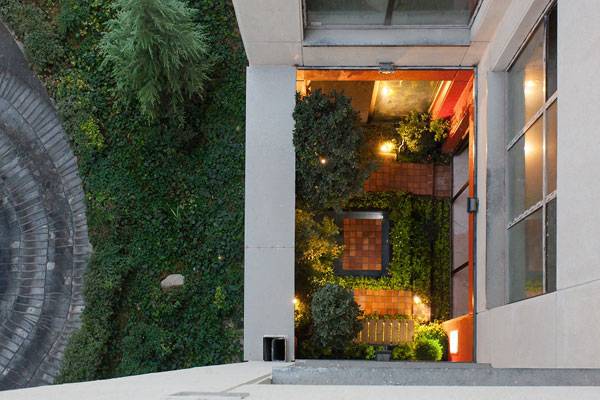
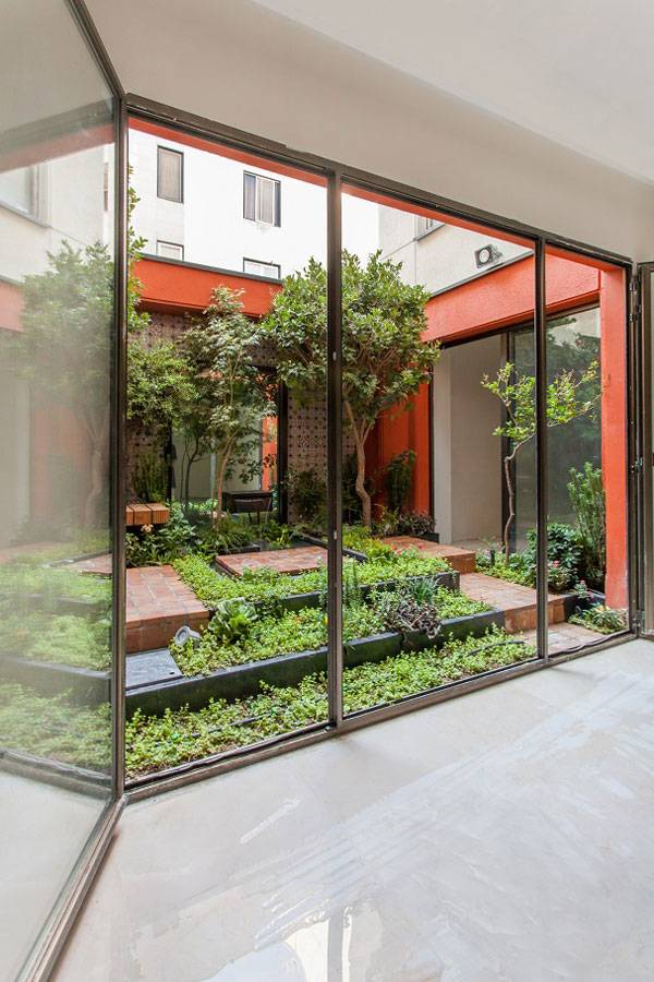
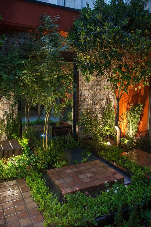
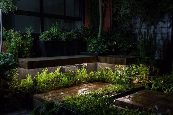
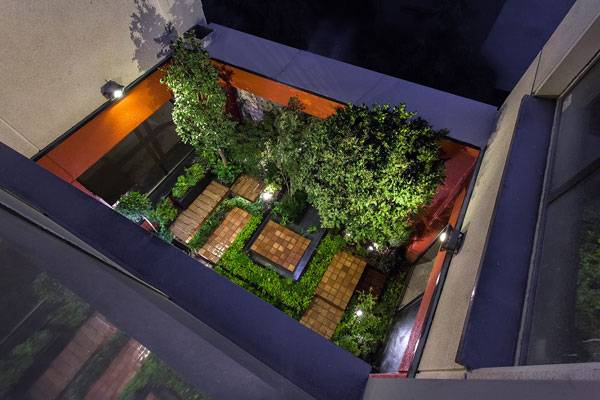
Article by Erisa Nesimi Reflecting Courtyard, By Modaam Architects, in Tehran, Iran. Located in the same area as the settlements of Ancient Persia, Tehran is not the same city it used to be. The tradition of wonderful gardens which once made the Persian Empire famous through the ages has been lost in the attempts at progress towards a modernized world. In this article we are looking at a project which aims to bring back forgotten concepts that used to make these cities great. Modaam Architects frame their project as: “A hopeful attempt to recall these yards which are lost among the municipal codes, parking ramps and the gray mass of buildings” and “In search of lost yard”.
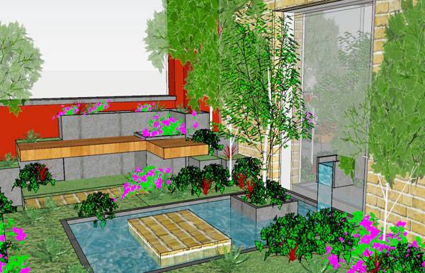
Reflecting Courtyard. Image courtesy of Modaam Architects
Reflecting Courtyard by Modaam Architects
Related also to its name, this is a project of reflection on the past. Their proposal is not only helpful towards the environment, but it’s a recall to the gardens of the past which made their environments enjoyable places in which to live. Lately, not only Tehean, but the world in general, is losing the vitality and spirit of places. But, what makes this project special?
Reflecting Courtyard. Image courtesy of Modaam Architects
Reflecting Courtyard. Image courtesy of Modaam Architects
Reflecting Courtyard. Image courtesy of Modaam Architects
Reflecting Courtyard. Image courtesy of Modaam Architects
Reflecting Courtyard. Image courtesy of Modaam Architects
- Award Winning Small Garden Design
- Why This Courtyard Garden Works When so Many Others Fail?
- Designer Achieves Outstanding Results With Terraced Garden
Reflecting Courtyard. Image courtesy of Modaam Architects
Reflecting Courtyard. Image courtesy of Modaam Architects
Reflecting Courtyard. Image courtesy of Modaam Architects
Reflecting Courtyard. Image courtesy of Modaam Architects
Reflecting Courtyard. Image courtesy of Modaam Architects
Reflecting Courtyard. Image courtesy of Modaam Architects
Reflecting Courtyard. Image courtesy of Modaam Architects
Full Project Credits For the Reflecting Courtyard by Modaam Architects :
Project Name: Reflecting Courtyard Location: Tehran, Iran Client: Mr. Kardanpour Construction: Sazeh Sadr Architects: Modaam Architects Photographer: Alireza Behpour Learn more about Modaam: Website: www.modaam.com Facebook: www.facebook.com/modaam.architects LinkedIN: www.linkedin.com/in/modaam-architects Architizer: www.architizer.com/firms/modaam Blog: www.modaam.com/blog/ Recommended Reading:
- Becoming an Urban Planner: A Guide to Careers in Planning and Urban Design by Michael Bayer
- Sustainable Urbanism: Urban Design With Nature by Douglas Farrs
Article by Erisa Nesimi


An Amazing 5 Star Landscape at the Four Seasons Hotel
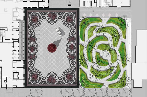
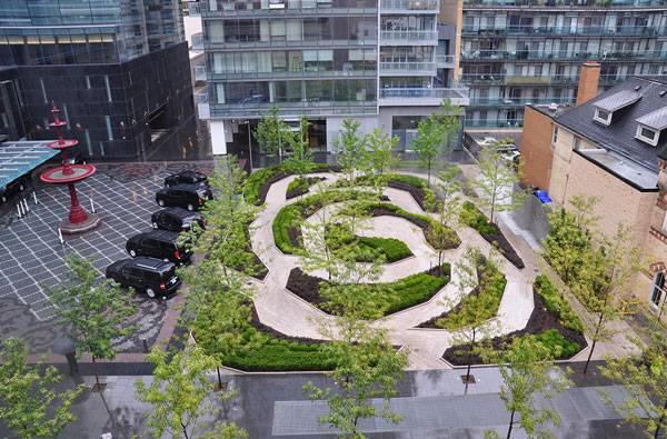
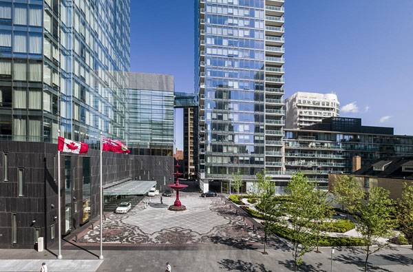
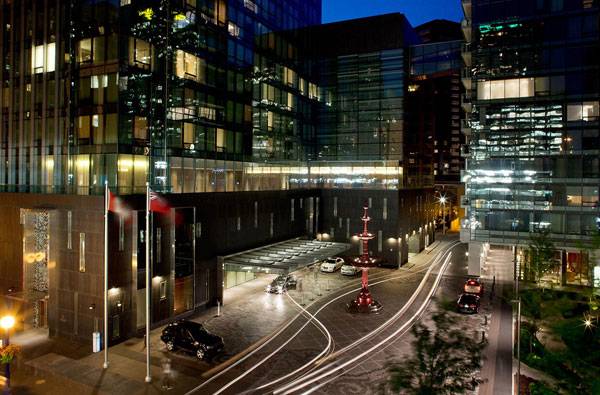
Article by Tahío Avila The Four Seasons Hotel and Residences Landscape Design by Claude Cormier + Associés, in Toronto (Ontario), Canada. Claude Cormier is an internationally acclaimed landscape architect and urban designer based in Montreal, Canada, whose projects can be seen around the world. His work is very multidisciplinary, and some people describe it as graphic and playful (we are about to see that in this article). I would call him an audacious and authentic conceptual designer who stands behind his beliefs.
The Four Seasons Hotel and Residences
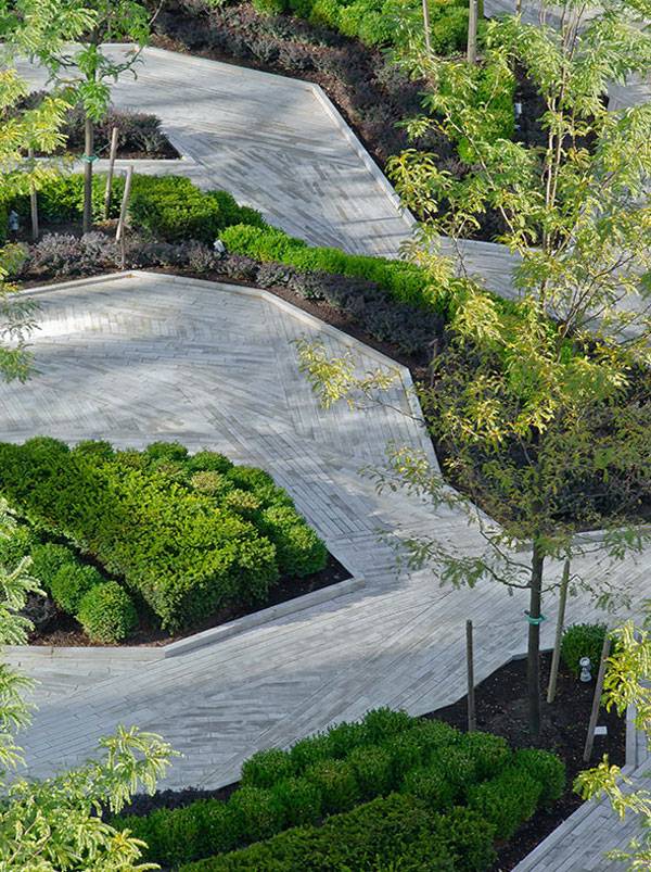
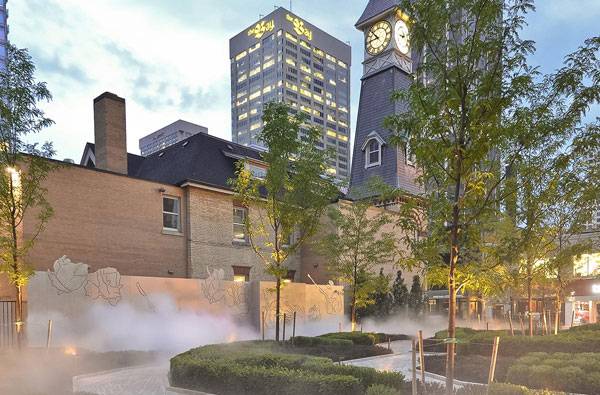
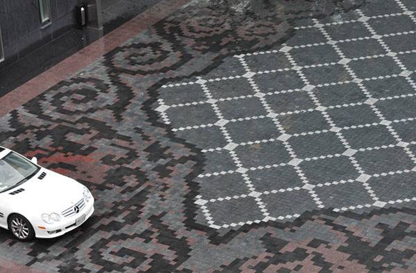
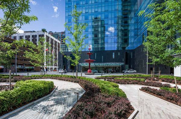
Located on Bay Street in Toronto’s Yorkville neighborhood, the project consists of the hotel, a public library, and a fire hall. The designers created an urban carpet, a rose-shaped garden, and a public park to bring it all together.
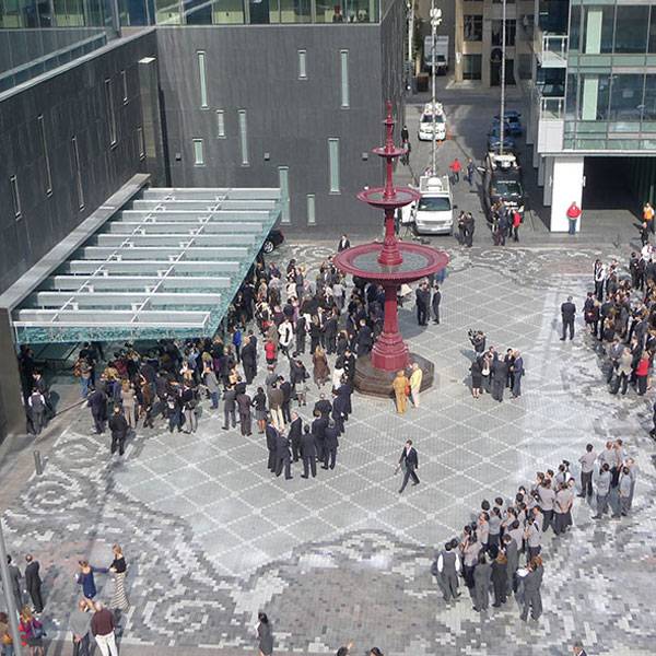
The Four Seasons Hotel and Residences Landscape Design. Photo courtesy of Claude Cormier + Associés
The Four Seasons Hotel and Residences Landscape Design. Photo courtesy of Claude Cormier + Associés
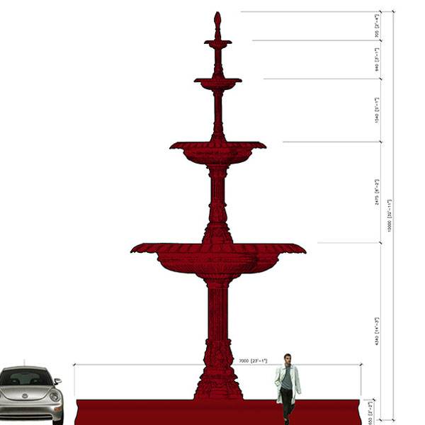
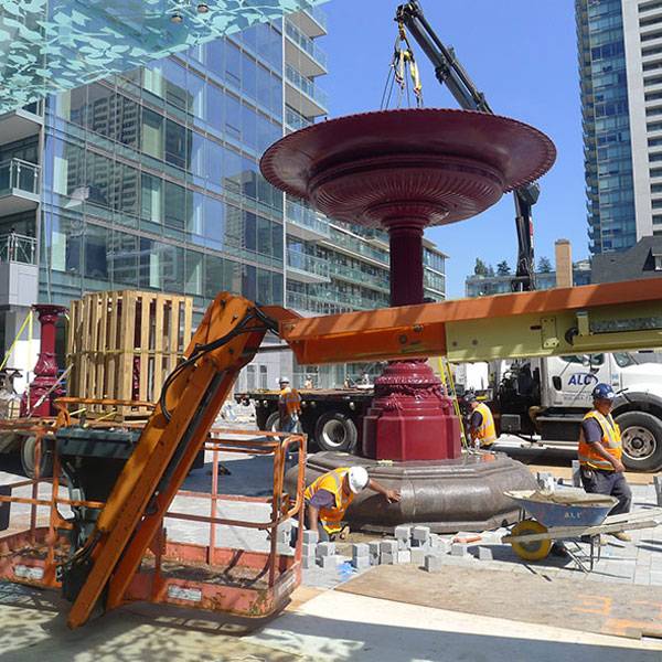
The Four Seasons Hotel and Residences fountain. Image courtesy of Claude Cormier + Associés
The Four Seasons Hotel and Residences Landscape Design. Photo courtesy of Claude Cormier + Associés
The Four Seasons Hotel and Residences Landscape Design. Photo courtesy of Claude Cormier + Associés
The Four Seasons Hotel and Residences Landscape Design. Photo courtesy of Claude Cormier + Associés
The Four Seasons Hotel and Residences Landscape Design. Photo courtesy of Claude Cormier + Associés
The Four Seasons Hotel and Residences Landscape Design. Photo courtesy of Claude Cormier + Associés
The Four Seasons Hotel and Residences Landscape Design. Photo courtesy of Claude Cormier + Associés
The Four Seasons Hotel and Residences Landscape Design. Photo courtesy of Claude Cormier + Associés
The Four Seasons Hotel and Residences Landscape Design. Photo courtesy of Claude Cormier + Associés
The Four Seasons Hotel and Residences Landscape Design. Photo courtesy of Claude Cormier + Associés
The Four Seasons Hotel and Residences fountain. Image courtesy of Claude Cormier + Associés
Full Project Credits For The Four Seasons Hotel and Residences Landscape Design:
Project Name: The Four Seasons Hotel and Residences Landscape Design Landscape Architect: Claude Cormier + Associés Project Duration: 2006-2014 Location: Toronto (Ontario), Canada Client: Menkes Developments, Lifetime Developments Collaboration: Architects Alliance, Page + Steele / IBI Group Architects, NAK Design Area: 4 000 m2 (1 acre) Status: Built Awards: Toronto Urban Design Award Award of Merit – Small Open Spaces Category Azure Best Landscape Architecture Design – Finalist Canadian Society of Landscape Architects – Regional Honor – Design Category Learn more about Claude Cormier + Associés: Website: www.claudecormier.com Recommended Reading:
- Becoming an Urban Planner: A Guide to Careers in Planning and Urban Design by Michael Bayer
- Sustainable Urbanism: Urban Design With Nature by Douglas Farrs
Article by Tahío Avila


Why Listening to the End Users is the Key to Great Design
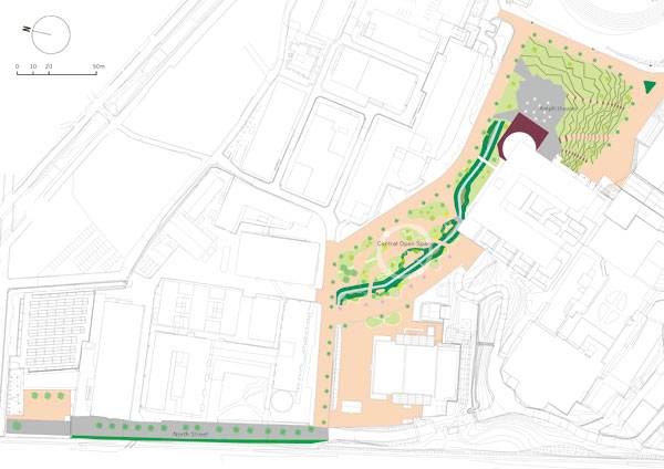
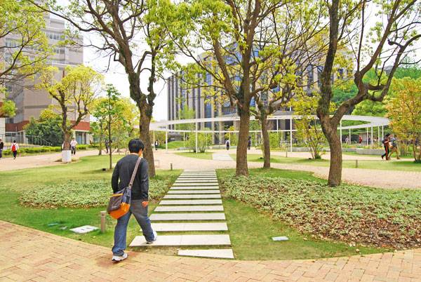
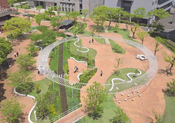
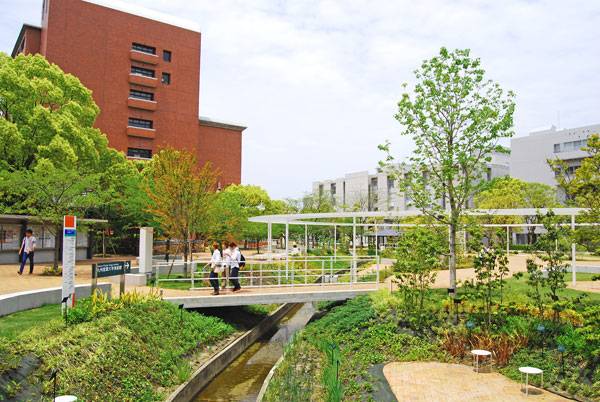
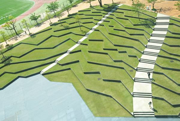
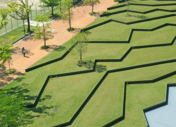
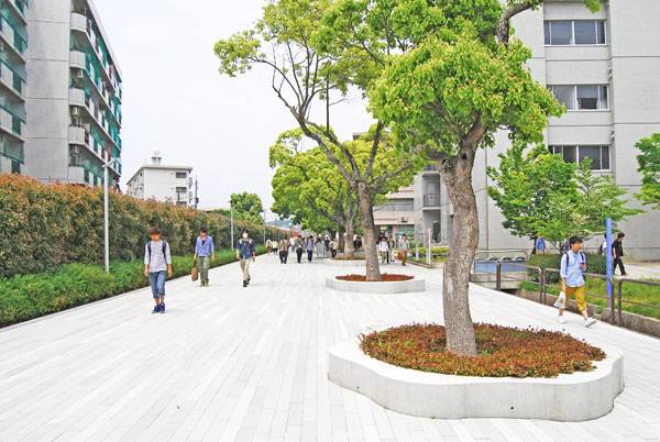
Article by Carlos Cortés Kyushu Sangyo University Landscape Design, by DESIGN NETWORK +ASSOCIATES, Fukuoka, Japan. For Principal Designer Shunsuke Furuie of DESIGN NETWORK +ASSOCIATES, “The word ’landscape‘ suggests the presence or activities of human beings.” He also states that; “landscape architects should create environments that affirm the presence of people.” As student or professor, there is one thing that can make a great difference in how you develop your activities at the university. We are talking about our relation with the place where we spend lots of hours as we study or work. In this article we take a look on how DESIGN NETWORK +ASSOCIATES managed to design a park-like campus that revitalizes and brings cohesion through the flow of people between spots placed over a renovated landscape that consists of three major areas at Kyushu Sangyo University.
Masterplan of Kyushu Sangyo University Landscape Design. Image courtesy of DESIGN NETWORK +ASSOCIATES
Central Plaza at Kyushu Sangyo University. Image courtesy of DESIGN NETWORK +ASSOCIATES
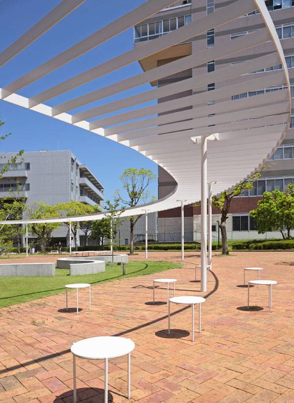
Three Major Areas at Kyushu Sangyo University
Central Plaza: Furniture to Enjoy the Landscape Distinctive for its oval pergola, the Central Plaza connects directly to the other major areas. There you can use one of those cloud-shaped benches or three-legged stools, or admire the curved lines that complete the white colored furniture of the site. On those you can relax and enjoy the beautiful variety of plants including shrubs, flowering perennial herbs, vines and trees that embrace seasonal change.Perhaps you would like to take a walk and read the descriptions of each type of featured plant.
Central Plaza at Kyushu Sangyo University. Image courtesy of DESIGN NETWORK +ASSOCIATES
Central Plaza at Kyushu Sangyo University. Image courtesy of DESIGN NETWORK +ASSOCIATES
Central Plaza at Kyushu Sangyo University. Image courtesy of DESIGN NETWORK +ASSOCIATES
- Reinterpreting Nature in Design: Teikyo Heisei University Nakano Campus
- Tokyo Warehouse Sets The Stage for The La Kagu Event Space
- How A Symbol of Tragedy Can Encourage People to Look into the Future
Amphitheater at Kyushu Sangyo University. Image courtesy of DESIGN NETWORK +ASSOCIATES
Amphitheater at Kyushu Sangyo University. Image courtesy of DESIGN NETWORK +ASSOCIATES
North Street at Kyushu Sangyo University. Image courtesy of DESIGN NETWORK +ASSOCIATES

Central Plaza at Kyushu Sangyo University. Image courtesy of DESIGN NETWORK +ASSOCIATES

Amphitheater at Kyushu Sangyo University. Image courtesy of DESIGN NETWORK +ASSOCIATES
Full Project Credits For DNA:
Project: Kyushu Sangyo University Landscape Design Designers: DNA – DESIGN NETWORK +ASSOCIATES Location: Fukuoka, Japan Date of Construction: 2012 Size: Building Area 4,100㎡ (stage 1) / 6,600㎡ (stage 2) Client: Kyushu Sangyo University Learn more about DNA: Website: www.dna1986.jp Blog: www.dnandn.exblog.jp Facebook: www.facebook.com Instagram: www.instagram.com/dna_1986 Recommended Reading:
- Becoming an Urban Planner: A Guide to Careers in Planning and Urban Design by Michael Bayer
- Sustainable Urbanism: Urban Design With Nature by Douglas Farrs
Article by Carlos Cortés


The Most Eco Friendly Cities in the World and What You Can Learn From Them
Article by Brooklyn Williams We take a look at eco friendly cities around the world that are leading the way with their environmental initiatives. Certainly landscape architecture is important for your home base, but what about city-wide? Isn’t it important that the entire city feature cohesive architecture and landscaping? These efforts don’t have to cost a fortune; nor, do these efforts have to increase a city’s carbon footprint. The following are cities that have the right idea in terms of going green and looking good all the while. Before you read about how the following cities are reducing their carbon footprints, consider that you can be a catalyst for change in your own city. Of course, your the landscape is beautiful and that shouldn’t change, but consider reducing the amount of water you’re using. You could also look into switching to greener electricity providers.
Israels Square by COBE in Copenhagen, Denmark. Photo credit: Rasmus Hjortshoj
Eco Friendly Cities
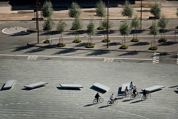
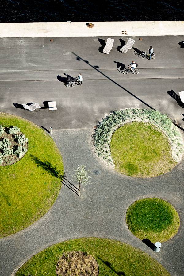
Copenhagen, Denmark Due to its eco-innovation and sustainable employment initiatives, Copenhagen was the recipient of 2014’s European Green Capital. Considering the city intends to be carbon-neutral by 2025, it’s likely the city will receive the reward at least one more time. With its many bike paths and clean, cobbled streets, Copenhagen isn’t just a green city, it’s a beautifully landscaped city too.
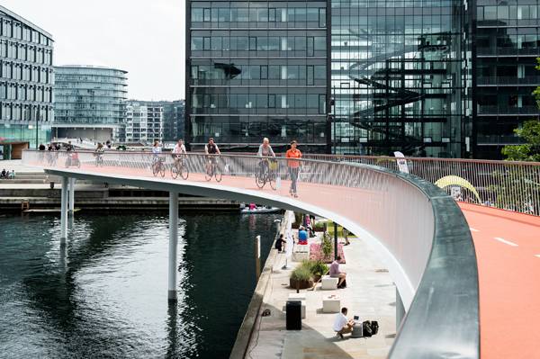
Can Copenhagen be the best cycling city in the world? Credit: DISSING+WEITLING
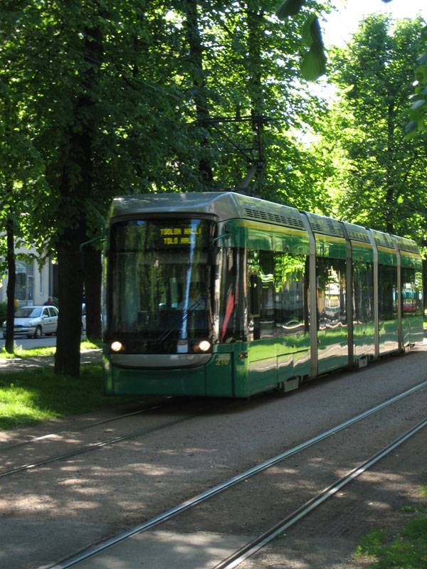
“A Tram in Helsinki Finland” by I, Pöllö. Licensed under CC BY 2.5 via Wikimedia Commons
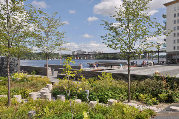
Sjövikstorget Square, by Andersson Thorbjörn with Sweco architects, Stockholm, Sweden
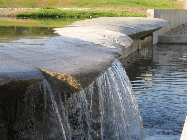
Holalokka in Oslo. Photo credit: Dreiseitl
- Becoming an Urban Planner: A Guide to Careers in Planning and Urban Design by Michael Bayer
- Sustainable Urbanism: Urban Design With Nature by Douglas Farrs
Article by Brooklyn Williams


Is Atlantic Wharf Park a Sustainable Success Story?
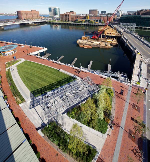
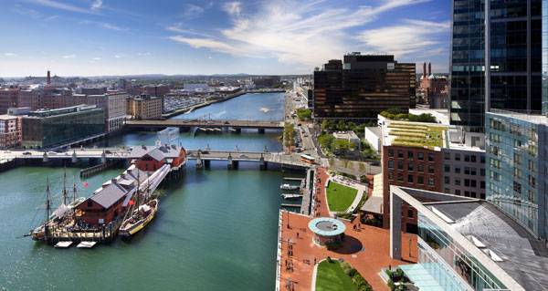
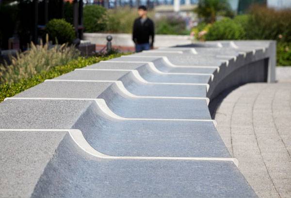
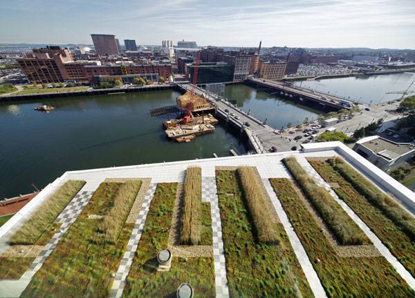
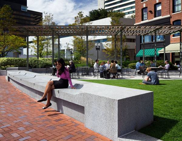
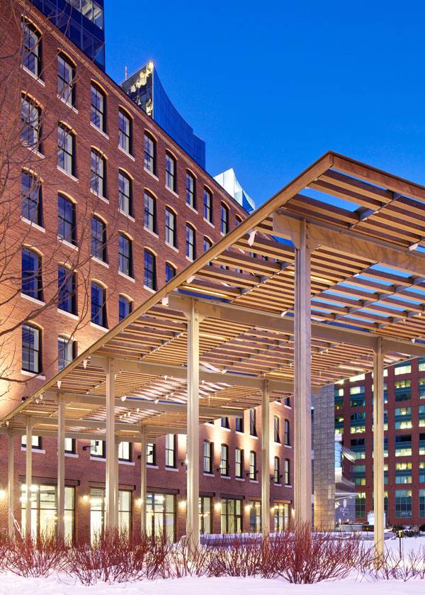
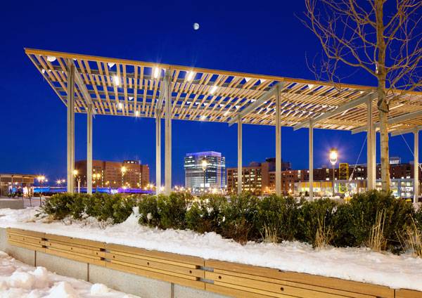
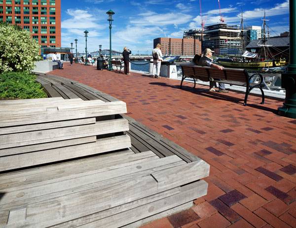
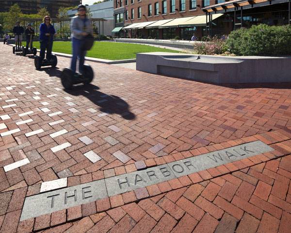
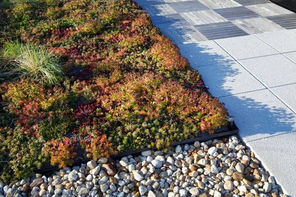
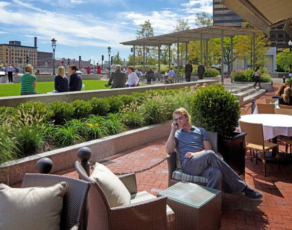
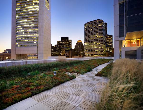
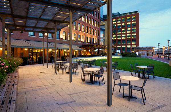
Article by Paula Uzarek. Atlantic Wharf Park, by Halvorson Design Partnership, Boston, Massachusetts. Designing a space in a district with historic roots can give a landscape architect a series of sleepless nights. How does one create a fresh, new space while protecting and preserving the past? Should the designer take the risk and move beyond scheme, or just create a safe project? Can these two ways of thinking be combined? Atlantic Wharf in Boston, designed by Halvorson Design Partnership, takes a fresh look at a historic site and presents a solution that both preserves and improves the space.
Atlantic Wharf Park. Photo credit: Ed Wonsek
Atlantic Wharf Park
Connection is Vital Located in a lively Boston district, Atlantic Wharf faces the Fort Point Channel, named after a fort that dates back to America’s colonial epoch. The channel is surrounded by busy banks full of historical buildings, and sits less than half a mile from South Station, where buses, the subway and trains are only a few of the transportation options. Water taxi is also an option here. The public transportation reduces pollution through less car use, and encourages pedestrians to explore the area. The Harborwalk connects the wharf with other public spaces within the harbor and provides an outstanding walking route.
Atlantic Wharf Park. Photo credit: Ed Wonsek
Atlantic Wharf Park. Photo credit: Ed Wonsek
Atlantic Wharf Park. Photo credit: Ed Wonsek
Atlantic Wharf Park. Photo credit: Ed Wonsek
Atlantic Wharf Park. Photo credit: Ed Wonsek
Atlantic Wharf Park. Photo credit: Ed Wonsek
Atlantic Wharf Park. Photo credit: Ed Wonsek
- Channel Center Park and Iron Street Park Bring Life into Boston
- Levinson Plaza Creates a Green Refuge in the City
- Top 10 Walkable Cities
Atlantic Wharf Park. Photo credit: Ed Wonsek
Atlantic Wharf Park. Photo credit: Ed Wonsek
Atlantic Wharf Park. Photo credit: Ed Wonsek
Atlantic Wharf Park. Photo credit: Ed Wonsek
Atlantic Wharf Park. Photo credit: Ed Wonsek
Full Project Credits For The Rail Corridor:
Project Name: Atlantic Wharf Park Location: Boston, Massachusetts Landscape Architects: Halvorson Design Partnership Architects: CBT Architects Green Roof Budget: $18,000 Construction Budget: $3 million (Harborwalk + Green Roof) Date of Design: 2009-2010 Size: 2.2 acres (including 0.75-acre plaza), 18,000 SF green roof Client: Boston Properties Year of Construction: 2011 Photography Credit: Ed Wonsek Project Team: Landscape Architects: Halvorson Design Partnership, Inc. Architects: CBT Architects Marine Engineer: Childs Engineering Corporation Civil Engineer: VHB, Inc. Traffic Engineer: Howard Stein Hudson Associates Inc. Structural Engineer: McNamara Salvia, Inc. Client: Boston Properties AWARDS: 2011 Preservation Achievement Award, Boston Preservation Alliance; 2013 LEED Platinum Certified, US Green Building Council Learn more about Halvorson Design Partnership: Website: www.halvorsondesign.com Facebook: www.facebook.com/Halvorson-Design-Partnership-Inc LinkedIN: www.linkedin.com/company Recommended Reading:
- Becoming an Urban Planner: A Guide to Careers in Planning and Urban Design by Michael Bayer
- Sustainable Urbanism: Urban Design With Nature by Douglas Farrs
Article by Paula Uzarek.


Can This Winning Design Revive Urban Connections?
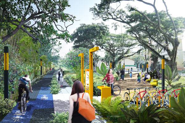
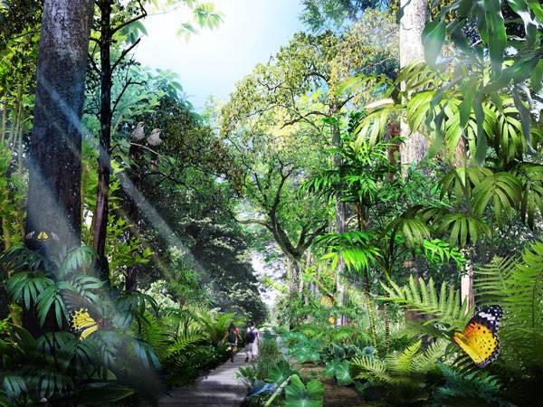
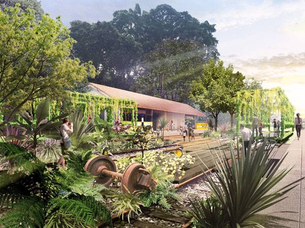
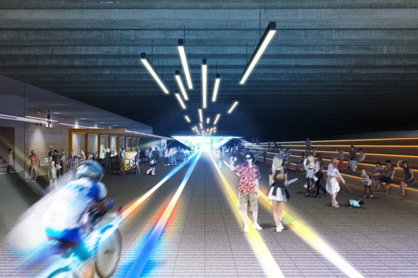
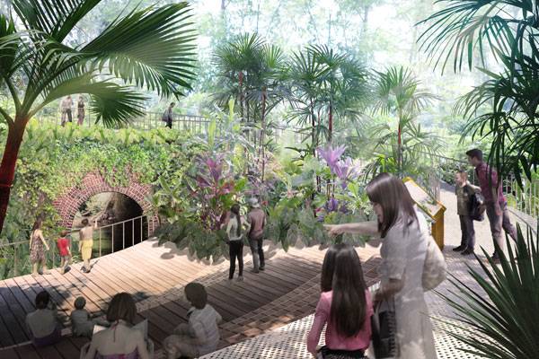
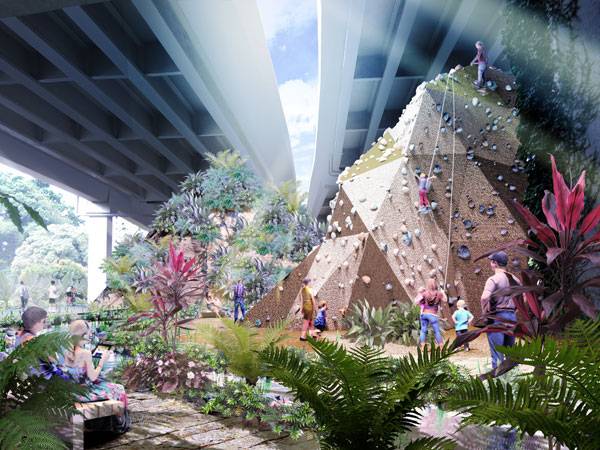
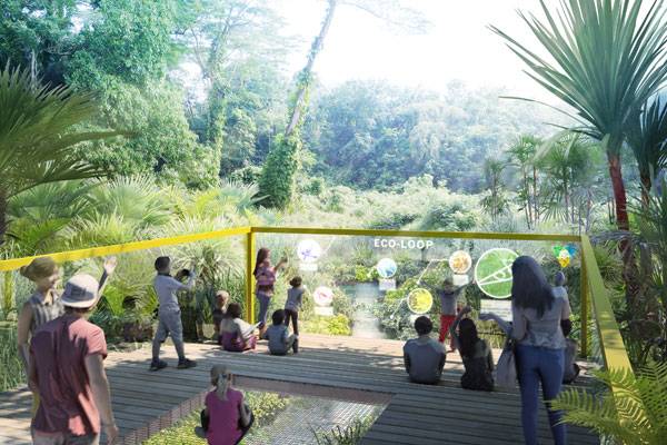
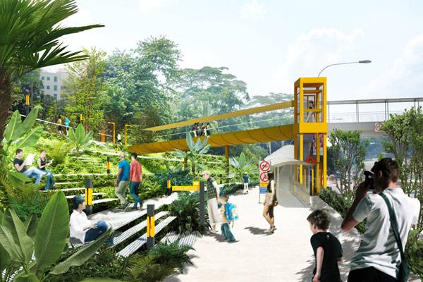
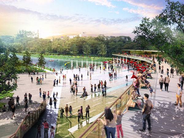
Article by Farah Afza. Rail Corridor, by Tierra Design and Japanese firm Nikken Sekkei, in Singapore. Designers create space to create different moods for the users. It is the users’ experience which ultimately describes a space. The adjectives intriguing, dull, vibrant, serene, etc. are added only to describe a space based on the experiences of its users. A space however, well designed as it may be, will be functional and successful only when it can accommodate different sorts of activities. Therefore, accommodating various activities in a site is one of the toughest challenges faced by designers during design decisions and it should be of major concern when the design is for the urban environment. The introduction of well-thought-out activity nodes can definitely revive the urban connections, uniting the community of the designed area.
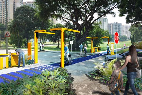
The Rail Corridor. Image courtesy of Tierra Design
Rail Corridor Singapore
One such exemplary project is the Rail Corridor; an award-winning master plan proposal by Japanese firm Nikken Sekkei (Lead Landscape Architect & Lead Architect) with Tierra Design (Local Landscape Architect) in Singapore.
The Rail Corridor. Image courtesy of Tierra Design
The Rail Corridor. Image courtesy of Tierra Design
The Rail Corridor. Image courtesy of Tierra Design
The Rail Corridor. Image courtesy of Tierra Design
The Rail Corridor. Image courtesy of Tierra Design
The Rail Corridor. Image courtesy of Tierra Design
The Rail Corridor. Image courtesy of Tierra Design
The Rail Corridor. Image courtesy of Nikken Sekkei
The Rail Corridor. Image courtesy of Nikken Sekkei
The Rail Corridor. Image courtesy of Nikken Sekkei
The Rail Corridor. Image courtesy of Nikken Sekkei
Full Project Credits For The Rail Corridor:
Project Name: Rail Corridor Location: Singapore Size: 24km Awards: winner of the Urban Redevelopment Authority’s (URA) design competition for the future of the former KTM railway land Client: Urban Redevelopment Authority (URA) Designers: Nikken Sekkei with Tierra Design, in Singapore Learn more about Tierra Design: Website: www.tierradesign.com.sg Facebook: www.facebook.com/Tierra.POD Recommended Reading:
- Becoming an Urban Planner: A Guide to Careers in Planning and Urban Design by Michael Bayer
- Sustainable Urbanism: Urban Design With Nature by Douglas Farrs
Article by Farah Afza. Return to Homepage

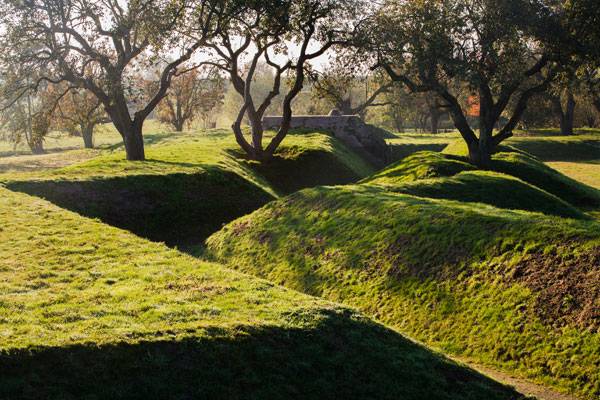
How to Transform an Old Military Area into a Peaceful Park
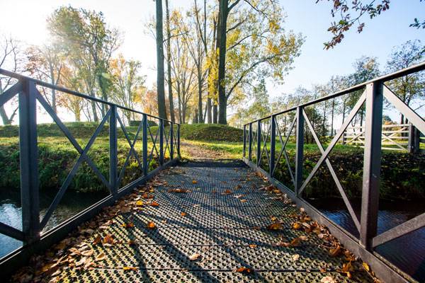
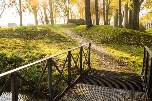
Article by Irmak Bilir. Green Road, a peaceful park by REDscape Landscape & Urbanism, Province of Utrecht, the Netherlands. Nobody would deny that no matter the results of a battle, a military area can be depressing. One of the best ways to transform such a site is to turn it into a park. But not an ordinary park — a park that shares its history with its visitors. Green Road does exactly that, in a project designed by REDscape, led by landscape architect Patrick Mc Cabe.
A Breif History of Green Road
Green Road is a large military area in the Province of Utrecht, the Netherlands, which has housed a former defensive trench and bunker system since 1918. The area was a defender of the River Lek for invasion from the east, and it was built for this purpose. It has forts, works, and a wide of variety of bunkers. In the past, the area had become overgrown and part of trench system was removed, making access to the area difficult. This left the area a sad reminder of World Wars I and II.
Green Road. Photo credit: Andreas Mulder
Green Road. Photo credit: Andreas Mulder
Green Road by REDscape Landscape & Urbanism
Healing a landscape affected by war is not the same as with an ordinary site. It brings up its own feelings and memories, and it’s important to respect that. The design must show and teach the history in some way, while at the same time healing the negative connotations of the area.
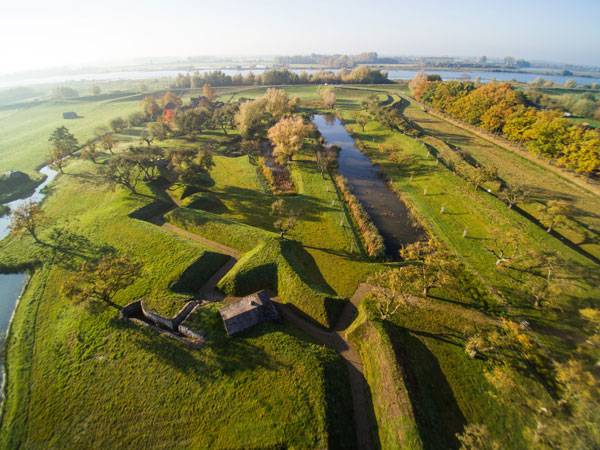
Photo credit: Philip van Roosmalen and Andreas Mulder
Green Road. Photo credit: Andreas Mulder
Allowing Visitors to Experience the Site’s Original Intention
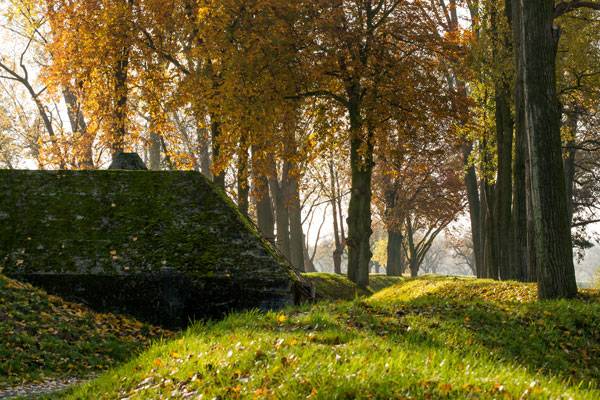
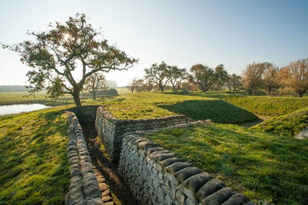
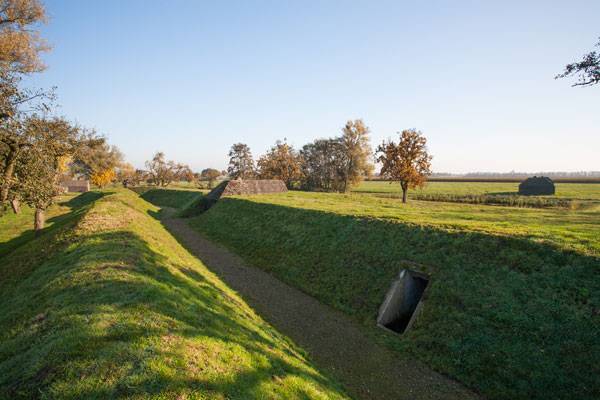
The defensive works were reconstructed, allowing visitors to experience the site’s original intention, and the bunkers tell the story of its wartime past. All of these show us that Green Road respects the history of the military park and protects its significance. By preserving its military history, Green Road’s topography takes a shape different in style from its surroundings. It has a shifting surface, which is a plus point feature in the Netherlands, and the ponds embellish the site with their bridges.
Green Road. Photo credit: Andreas Mulder
Ecology and Nature at the Forefront of the Project
Green Road is also a regenerative place with its fauna and flora. Ecology and nature are in the forefront of the project. For diversity, four new ecological zones were created. Additionally, a local pomological volunteer group had maintained the unique fruit trees of the area, and they are used to camouflage the defensive works. Especially fruitful apple trees are very common in the area. See More Fascinating Projects in the Netherlands:
- Stirring Emotions at the Netherlands Army Museum and Netherlands Air Force Museum
- How Mathildeplein Creates a Green Oasis in the City
- Giant Sized Pergola Creates Ecological Haven
There are also some freshwater habitats for amphibians, tree cover for nesting owls, and open grassland areas for foraging birds. Bats inhabit some of the bunkers and colorful species of butterflies abound. In other words, the military park is remarkably animal-friendly.
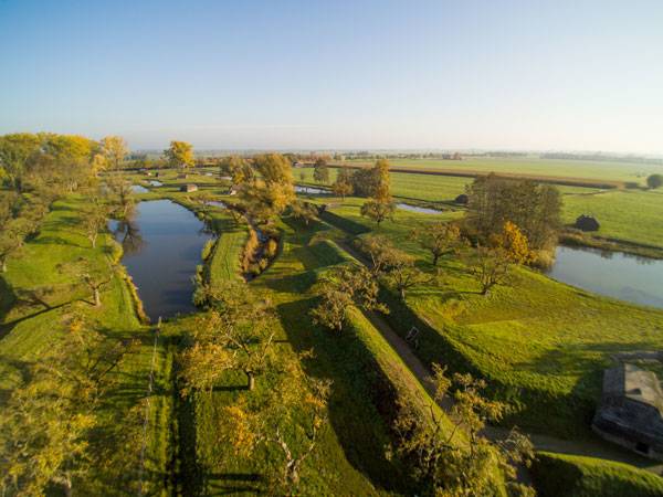
Photo credit: Philip van Roosmalen and Andreas Mulder
Green Road. Photo credit: Andreas Mulder
Green Road. Photo credit: Andreas Mulder
Connecting the Park to Adjacent Forts
A tourist ferry will connect the park with the adjacent forts of Honswijk, Spoel, and Everdingen. One of the bunkers is to be excavated to become freestanding in water, with possible use as a single-bedroom hotel. It’s sure that the Green Road military park will be a new attraction for locals and tourists. The design not only protects the history of the area and showcases this heritage perfectly to visitors, but also has a remarkably nice development on ecology, flora, and fauna, as well as converting a sad memorial and discounted place into a peaceful park. With all these features, it is worth a visit to see history and nature at the same time. Are you planning to visit? What do you think about the design? Let us know in the comments below! Click Here to Comment

Photo credit: Philip van Roosmalen and Andreas Mulder
Full Project Credits For Green Road:
Project Name: Green Road Designers: REDscape Landscape & Urbanism Location: Province of Utrecht, the Netherlands Budget: 350k Date of Design: 2010 Date of Construction: 2015 Lead Landscape Architect: Patrick Mc Cabe Project Area: 10 ha Client: Staatsbosbeheer, Linieland Photographs: Andreas Mulder (REDscape) and Philip van Roosmalen (drone images) Learn more about REDscape Landscape & Urbanism: Website: www.redscape.nl Facebook: www.facebook.com/REDscape-Landscape-Urbanism LinkedIN: www.linkedin.com/in/patrick-mc-cabe Recommended Reading:
- Becoming an Urban Planner: A Guide to Careers in Planning and Urban Design by Michael Bayer
- Sustainable Urbanism: Urban Design With Nature by Douglas Farrs
Article by Irmak Bilir Return to Homepage


How The Stunning UAE Pavilion Takes Inspiration Form The Desert
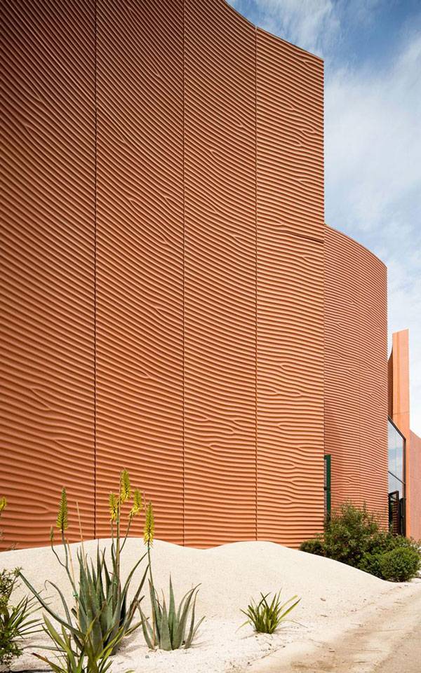
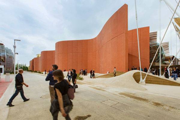
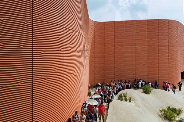
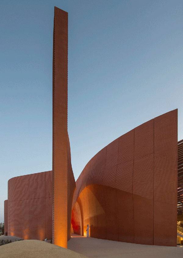
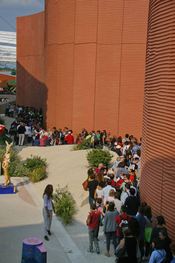
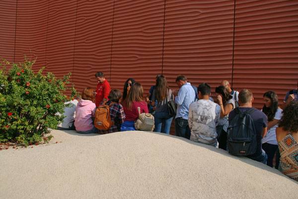
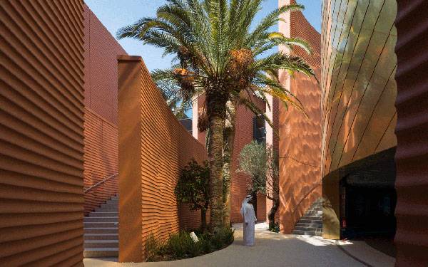
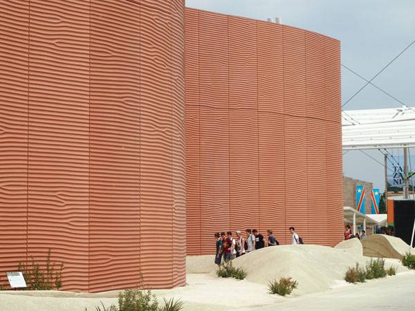
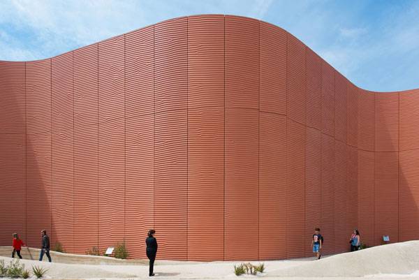
Article by Miriam Judith González Bolívar. UAE Pavilion by Foster+Parters and WATG in the Expo Milan 2015. Have you ever noticed the desert landscape? What do you think you can find there? Usually when we talk about it, what comes first to our minds is austerity, tons of sand, rocks, the horizon, and the infrequent lushness of an oasis? However, the desert still has his beauty. Dunes make the desert appear to be dancing and make it a dynamic landscape. And this is how Foster+Partners take the desert as an inspiration to create the concept and design for the Pavilion of the United Arab Emirates in “Expo Milan Feeding the Planet, Energy for Life 2015”. Transmitting the principles of ancient cities, the pavilion takes one of the principal urbanistic planning from Romans design: Decumanus.
UAE Pavilion. Image courtesy of WATG
UAE Pavilion. Image courtesy of WATG
Sandy Dunes
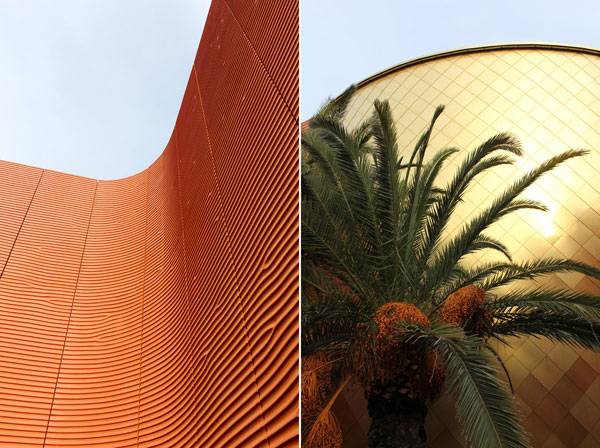
The sandy dunes are the path the visitors have to cross to see the pavilion. With a stretched and shaded corridor that simulates pedestrian streets and at the same time works as a queue, visitors get a clue of how the city looks and how life is experienced in the UAE. After crossing the paths, heading north, the round auditorium takes its place in the scenery. At 15 m high, its lining is made of copper alloy panels joined to each other at a 45° angle, covering the entire façade and continuing to the inside. Something that amazes the viewer is that the reflection of the sunlight makes patterns on the ground, feigning the sand in the desert. This only can be seen from the inside.
UAE Pavilion. Image courtesy of WATG
UAE Pavilion. Image courtesy of WATG
UAE Pavilion. Image courtesy of WATG
Rocky Desert
Located in the rear side of the pavilion, this part evokes the mountain landscape of the EAU. Unfortunately, time and budget didn’t allow representation of the environment in this area. However, the plantation of shrubs and palms suggests the flora of the country successfully. Plants were carefully selected to survive as long as the pavilion was exhibited. More berms were also constructed on this rear side, to enclose the planting zone.
UAE Pavilion. Image courtesy of WATG
Oasis
After passing through these areas, at the end of the tour, finally people get to the Oasis. The oasis was one of the first areas to be created. Located on the northeast of the building, the concept was based in the oasis in Al Ain. It took a special selection of trees and shrubs of different sizes to evoke a similar impression and to represent the sizes of palms there.
UAE Pavilion. Image courtesy of WATG
How Sustainability Plays an Important Role in the Design of the Pavilion
The pavilion was built under LEED principles using active and passive techniques as much as possible. Since the building satisfies green building necessities, it stands a good chance to garner platinum certification for its environmental performance. The building can be (and will be) dismantled from Milan and assembled in Masdar (a sustainable city in UAE) where it will be exhibited; all this can be possible thanks to materials used like the GRC (Glassfibre Reinforced Concrete) that makes an easy join between the panels, so they are reusable; zero-emission or electrical transportation from UAE to Milan and vice versa.
UAE Pavilion. Image courtesy of WATG
UAE Pavilion. Image courtesy of WATG
UAE Pavilion. Image courtesy of WATG
Full Project Credits For The UAE Pavilion
Project: UAE Pavilion Architect: Foster+Parters Landscape Architect: WATG Location: Expo Milan 2015 Area: 4,386 m² Date of construction: 2013-2015 Client: National Media Council Local Architect: Marco Visconti Visitor Experience Design: Land Design Studio Engineering, procurement & construction management: Rimond Rammed Earth Specialist: Rammed Earth Consulting, Rowland Keable Quantity Survey: Fraser Randall Management: A&A Company Plant supplier + installer: Tor San Lorenzo + Iperverde Ground contractor: Rimogreen Learn more about WATG: Website: www.watg.com Facebook: www.facebook.com/WATGdesign Twitter: www.twitter.com/WATG Google plus: www.plus.google.com Flickr: www.flickr.com/photos/watg LinkedIN: www.linkedin.com/company/watg YouTube: www.youtube.com/user/WATGChannel Pinterest: www.pinterest.com/watg/ Recommended Reading:
- Becoming an Urban Planner: A Guide to Careers in Planning and Urban Design by Michael Bayer
- Sustainable Urbanism: Urban Design With Nature by Douglas Farrs
Article by Miriam Judith González Bolívar Return to Homepage

Can Innovative Urban Games Improve Space and The Mind?
Article by Alexandra Wilmet PXATHENS by Buerger Katsota Architects, in Athens, Greece. In the education of a child, the discovery and exploration of nature and the environment are key elements to developing creative capacity and imagination. It is essential that our children can enjoy diverse play areas where they can draw inspiration, develop their team spirit, and socialize with the outside world. Unfortunately, playgrounds are often similar to each other. They rarely fit into their environment and are sometimes dilapidated. It is with the aim to remedy this lack of character that the project PXATHENS is taking place in the Greek capital; to offer young and old creative playgrounds, safe and accessible to all.

PXATHENS. Photo credit: Yiorgis Yerolymbos
One Project, Seven Principles
The idea to re-integrate the game into the streets of the city comes from an initiative of the organization “Paradeigmatos Harin” that has developed, in collaboration with the municipality of Athens, the PXATHENS project. This project involves six degraded and abandoned spaces in downtown areas. The office in charge of the restoration of these spaces defines a development strategy based on seven principles:
- Projection of references
- Places for all ages
- Catering to multi-dimensional play
- Identification of character holding the ground
- Negotiation of borders
- Folding the ground
- Negotiation of borders
- The Creation of a network

PXATHENS. Photo credit: Yiorgis Yerolymbos

PXATHENS. Photo credit: Yiorgis Yerolymbos

PXATHENS. Photo credit: Yiorgis Yerolymbos
Getting Fit in Urban Space
On the one hand, parkour is a physical activity that involves moving freely in space and especially where there is no set path. Urban objects are transformed into obstacles that must be overcome smoothly. Parkour participants develop a large capacity for running, jumping, climbing and balance. On the other hand, the street workout is using street furniture to build muscles. And although in some places the infrastructure is dedicated to the sport, it can also be done anywhere with the usual furniture such as benches, lampposts, etc.
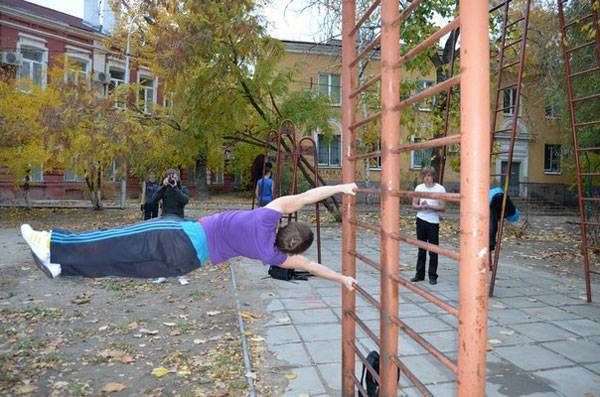
Building muscle, urban style. Image: “5 human flag” by Extrem7 – Own work. Licensed under CC BY-SA 3.0 via Wikimedia Commons
Six Identities in the City
But back on topic; the PXATHENS project is defined at six sites and there was never a question of drawing the same playgrounds in each place. Indeed, one of the seven principles is to give a distinct identity to each of the reallocated areas. The team in charge of the project identified a specific characteristic to each area which would become the predominant criterion for its unique identity and to serve as a reference. The presence of six properties; a church on the hill, a parcel at the corner of an urban block, an intersection, an inner courtyard whose entrance is hidden, an area of dense vegetation, and a location which refers to an ancient grove permitted these spaces to be named, respectively; Six Thresholds, Hill’s Plateaus, A Lot, Three Corners, Secret Garden and Forest Square.

PXATHENS. Photo credit: Yiorgis Yerolymbos

PXATHENS. Photo credit: Yiorgis Yerolymbos
Freedom of Expression
When we discover the place, we first notice the intriguing furniture. Indeed, the elements constructed for the project come in various colors and shapes; sometimes strange. The benches are circular shapes in concrete. They allow users to rest in the shade of the trees that encircle the space, but also represent an opportunity for sharing and creating social ties.

PXATHENS. Photo credit: Yiorgis Yerolymbos

PXATHENS. Photo credit: Yiorgis Yerolymbos

PXATHENS. Photo credit: Yiorgis Yerolymbos
Full Project Credits For PXATHENS
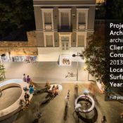
Project Name: PXATHENS Architects: Buerger Katsota Architects Design Team: Stephan Buerger, Demetra Katsota, Stephanos Conidaris, Flavian Lekkas, Francisco Serodio, Mladen Stamenic Client: City of Athens Project Initiator: Paradeigmatos Harin First phase donor: Stavros Niarchos Foundation Design Date: 2011-2012 Construction Date: Spring 2013 [1st phase] Photos: © Yiorgis Yerolymbos Location: Athens, Greece Surface Area: 840 sqm Year: 2013 Learn more about Buerger Katsota Architects: Website: www.buerger-katsota.com Recommended Reading:
- Becoming an Urban Planner: A Guide to Careers in Planning and Urban Design by Michael Bayer
- Sustainable Urbanism: Urban Design With Nature by Douglas Farrs
Article by Alexandra Wilmet Return to Homepage

10 of The Best Tourist Spots for Landscape Architecture in Europe
Article by Sophie Thiel We take a closer look at landscape architecture in Europe that also makes for great tourist destinations. We all know Hyde Park in London or Place de la République in Paris, but there are so many other landscape architecture projects worth visiting in Europe. The aim of this article was not to create a compilation of the 10 best-known tourist destinations in Europe, but to surprise you with relatively unknown landscape architecture projects to visit during your next trip. This list expands upon a previous article by Michelle Biggs: 4 incredible Tourism Projects of Landscape Architecture. Our new list features 10 must-see landscape architecture projects in Europe. Future articles will share projects from every other continent. So please enjoy reading and start planning where you would like to go first:
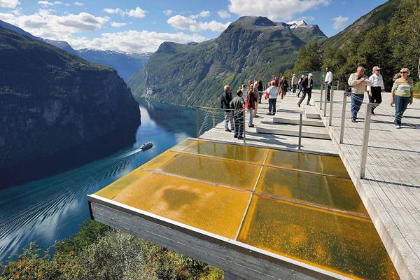
4 Incredible, Must-See Tourism Projects in Landscape Architecture. Viewpoint Ørnesvingen. Credit: 3RW Architects
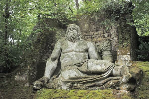
Monsters Park. Photo by Maura Caturano
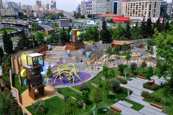
Zorlu Center. Photo credit: Oguz Meric
- How Landscape Design Became the Most Important Feature of Zorlu Center
- Zorlu Center, The Playground Where Imagination Comes to Play
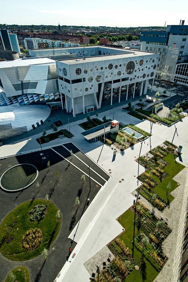
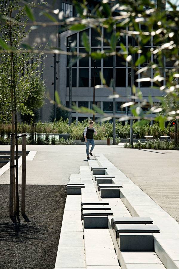
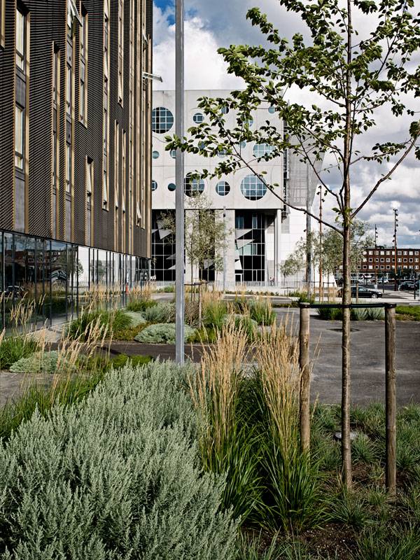
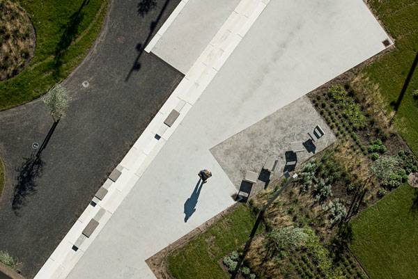
8. Dania Park — Malmö, Sweden, by Thorbjörn Andersson and Sweco Architects Dania Park is one of two seaside parks at the Western Harbour (Västra Hamnen), and therefore a part of the modern neighborhood of Malmö. Given this park’s poetic play with the sea, the wind, and the sky, it’s no surprise that this vast landscape is a favorite destination for residents and tourists throughout the year. At the various viewing points of Dania Park, people take a break from everyday life, unwind, and enjoy the spectacular sunsets in summer or the rough sea and troubled sky in winter.
Dania Park. Photo courtesy of Thorbjörn Andersson
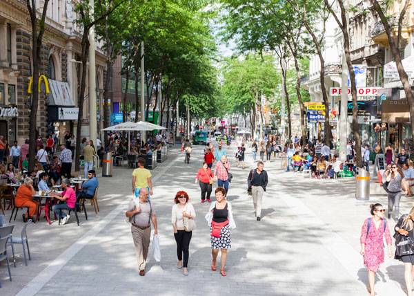
Mariahilfer Strasse. Photo credit: Ricky Rijkenberg
A buzzing cultural hub. Photo credit: Pieter Kers.
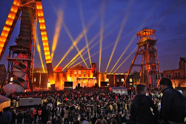
- Transforming a Coal Mining Site into a Cultural Hub
- Top 10 Ex-Industrial Sites Turned Into Stunning Landscapes
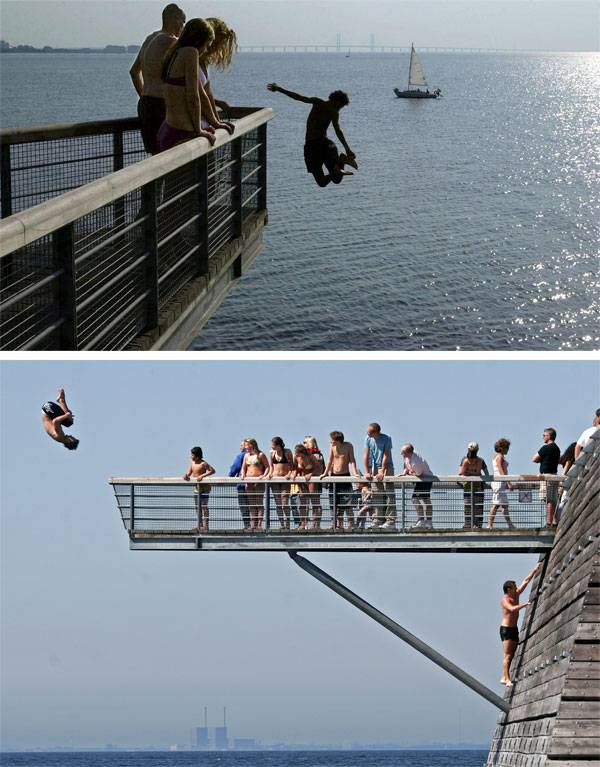
5. Vinterbad Brygge – Copenhagen, Denmark, by BIG Share the special bathing tradition with the Scandinavians at Vinterbad Brygge in Copenhagen. The harbor baths are a landmark for both residents and the city’s visitors. Enjoy the breathtaking view of the Copenhagen skyline while swimming, or appreciate the ceramic mosaics with humorous motifs while sweating in the sauna. Thermal bathing is an essential part of northern cultures and shouldn’t be missed when visiting Scandinavia, especially not at Vinterbad Brygge.
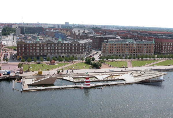
Vinterbad Brygge. Photo credit: BIG – Bjarke Ingels Group
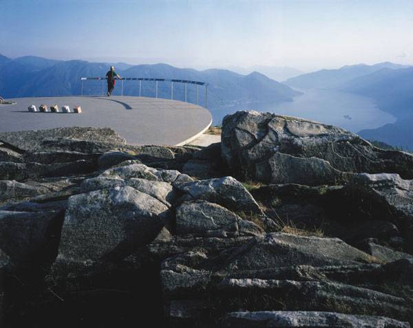
Cardada. Photo credit: Landecy
Velenje City Center Pedestrian Zone Promenada. Photo credit: Miran Kambič
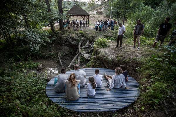
Ika Meditation Spot. Photo credit: Bence Pásztor
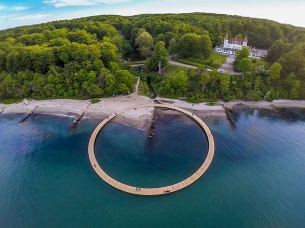
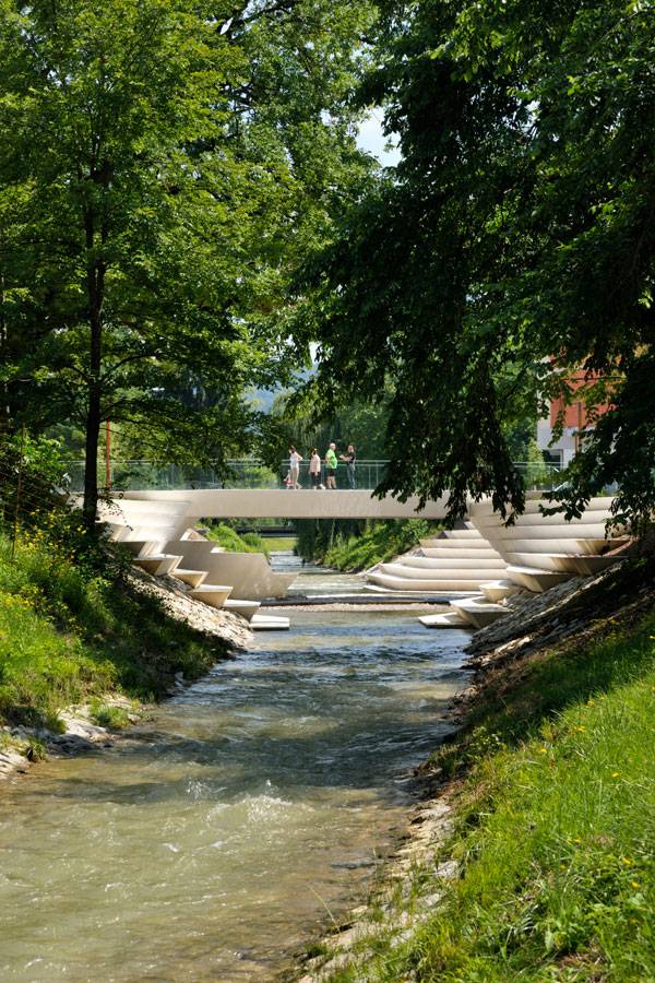
The Infinite Bridge. Photo credit: Aarhus I Billeder
Recommended Reading
- Natural Swimming Pools: Inspiration For Harmony With Nature by Michael Littlewood
- You Can Draw in 30 Days: The Fun, Easy Way to Learn to Draw in One Month or Less by Mark Kistler

Waterfront in Denmark Becomes a Major Centerpiece
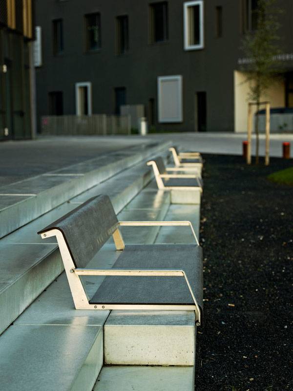
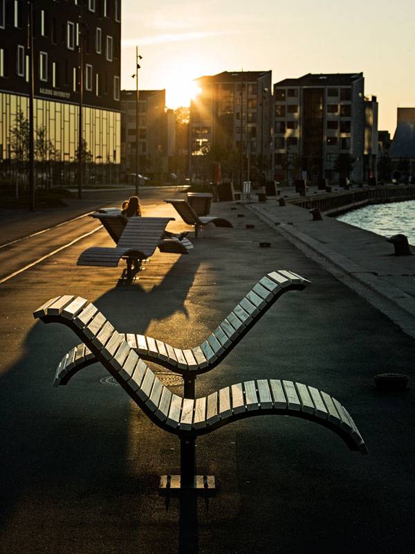
Article by Tahío Avila Aalborg Waterfront Phase II by C.F. Møller in Aalborg, Denmark. Aalborg is one of the most highly populated cities in Denmark. And despite the university city’s industrial heritage, Aalborg is concentrating on building a “cozy cosmopolitan atmosphere” along its waterfront, which recently has been transformed into a cultural quarter, with new university buildings, student housing, and a striking concrete music hall.
Aalborg Waterfront Phase II
The first phase of the project, begun in 2004 and completed in 2013, is a one-kilometer stretch of tree-lined, detailed boulevard for cyclists and pedestrians. It includes promenades with steps, recessed terraces, and urban gardens that facilitate activities such as markets, ball games, and sunbathing, while at the same time allowing people to get close to the water in a new harbor bath. The main idea was to create attractive spaces to benefit many different users and to let the Aalborg Castle become the harbor’s centerpiece, with a big green area and details to frame the historic embankments.
Aalborg Waterfront Phase II. Photo credit: Joergen True
The Second Phase
The second phase follows the same basic approach, with the promenade as a unifying element; in two years of construction (from 2013 to 2015), the designers have managed to link the city’s medieval center with the fjord and turn it into an attractive front for all types of users.
Aalborg Waterfront Phase II. Photo credit: Joergen True
Aalborg Waterfront Phase II. Photo credit: Joergen True
The Concept
The central idea of the second phase is the continuation of the waterfront promenade as a “marsh” or fusing component, in combination with a light, curving platform or plinth, upon which the buildings are located, as in a raised dune landscape.
Aalborg Waterfront Phase II. Photo credit: Joergen True
Aalborg Waterfront Phase II. Photo credit: Joergen True
Aalborg Waterfront Phase II. Photo credit: Joergen True
Aalborg Waterfront Phase II. Photo credit: Joergen True
The Master Plan
The master plan for Aalborg Waterfront links the city’s medieval town center with the adjacent fjord, which was previously difficult for citizens to access due to the industrial harbor and the associated heavy traffic. By tying in with the openings in the urban fabric, a new relationship between city and fjord is created, and what was formerly a back-side is turned into a new, highly attractive front.
Aalborg Waterfront Phase II. Photo credit: Joergen True
Materials
In contrast with the high-quality materials used in the plinth around the House of Music, the other surfaces used in the area are raw and simple: asphalt, steel, in situ-cast concrete, and wood were the materials used, just as in the first stage of Aalborg Waterfront.
Aalborg Waterfront Phase II. Photo credit: Joergen True
Aalborg Waterfront Phase II. Photo credit: Joergen True
Aalborg Waterfront Phase II. Photo credit: Joergen True
Full Project Credits For Aalborg Waterfront Phase II
Project Name: Aalborg Waterfront Phase II Architects: C.F. Møller Location: Aalborg, Denmark Client: Aalborg Municipality Landscape Design: C.F. Møller Engineer: COWI Lighting Design: ÅF Hansen & Henneberg Area: 170,000 sqm Year of Competition: 2012 Construction Period: 2013-2015 Prizes: 1st prize in architectural competition, 2012 Photographs: Joergen True Get Social with C.F. Moller: Website: www.cfmoller.com YouTube: www.youtube.com/user/cfmoller/videos Recommended Reading:
- Becoming an Urban Planner: A Guide to Careers in Planning and Urban Design by Michael Bayer
- Sustainable Urbanism: Urban Design With Nature by Douglas Farrs
Article by Tahío Avila Return to Homepage

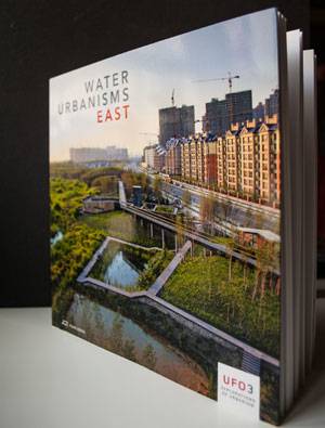
Water Urbanisms East | Book Review
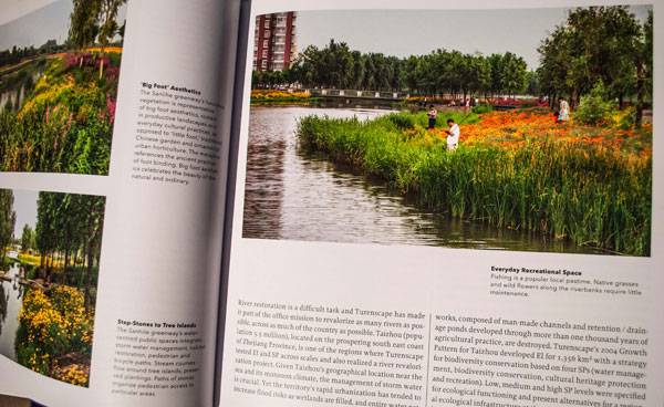
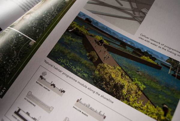
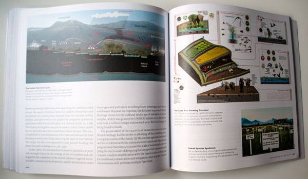
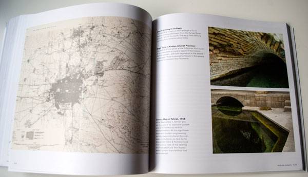
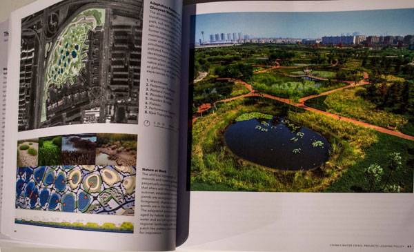
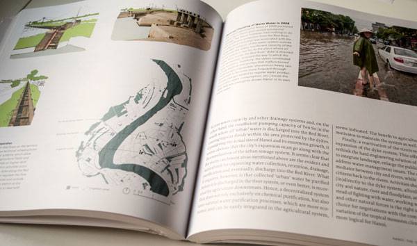
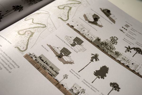
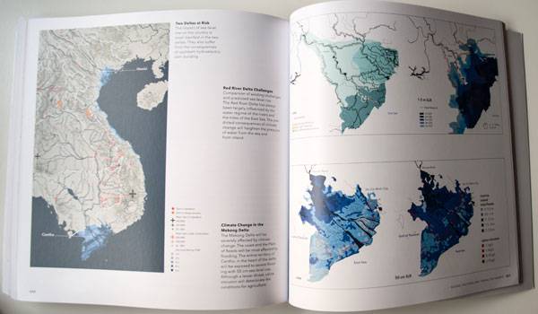
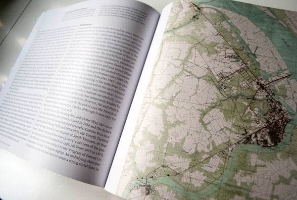
Book review by Yuliya Georgieva A book review of Water Urbanisms East by Kelly Shannon and Bruno de Meulder. In this era of the internet and instant sharing of information, reading books might sometimes seem old-fashioned. Some think that by the time books are written, edited, published, and distributed to the readership, they are already old. Yes, books get old, but they represent compilations of carefully selected, and in the case of landscape architecture, specialized information brought to us by experts that would take us ages to compile alone. Such is the case with Water Urbanisms East. This book represents a terrific compilation of diverse scale case studies on water-based practices in Asia, studying cities and landscapes from the past to today.
Front cover of Water Urbanisms East. Photo credit: Yuliya Georgieva
Whom is Water Urbanisms East For?
Whether you are a very experienced professional or just starting out in the field, this book will bring a completely new perspective on the interplay of landscapes, water, and cities. Water Urbanisms East is for anyone looking to re-discover, from a critical point of view, landscape and urbanism experiences through the spectrum of water as a structuring element, as well as for those just looking for ideas and inspiration from a foreign context.
Inside Water Urbanisms East. Photo credit: Yuliya Georgieva
Inside Water Urbanisms East. Photo credit: Yuliya Georgieva
Inside Water Urbanisms East. Photo credit: Yuliya Georgieva
Inside Water Urbanisms East. Photo credit: Yuliya Georgieva
Inside Water Urbanisms East. Photo credit: Yuliya Georgieva
Inside Water Urbanisms East. Photo credit: Yuliya Georgieva
Inside Water Urbanisms East. Photo credit: Yuliya Georgieva
Inside Water Urbanisms East. Photo credit: Yuliya Georgieva
Inside Water Urbanisms East. Photo credit: Yuliya Georgieva
- Landscape and Urban Design for Health and Well-Being
- Digital Drawing for Landscape Architecture
- 10 Books to Read in Your Fourth Year of Landscape Architecture
Pick up your copy of Water Urbanisms East today!
Book review by Yuliya Georgieva Return to Homepage